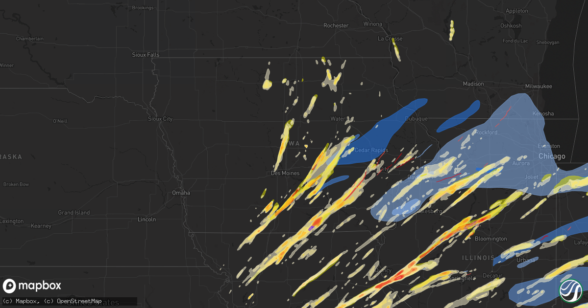
Hail Map in Iowa on March 31, 2023
Get this storm
March 31 map
$229
one time, instant access
Download today. No call, no setup
Keep the $229
Bought the map and want the full workflow? Apply the entire $229 to a subscription within 7 days. None of it is wasted.
Every map, not just this one
This buys you this map. Subscription and you get every map we run, in the markets you choose from a few cities to whole states to nationwide. Plus real-time alerts the moment a storm fires.
Contact data
Name, contact info, occupancy, even credit band for addresses in the footprint. You go from where it hit to who to call.
Become the source they trust
Unlimited branding weather history reports on demand. You already have the documented answer ready for the property owner, and you are the one who showed up with it.
Property data and RoofTrace estimates
Pull up any address you have got, its value and the exact code rules for that jurisdiction, straight from One Click Code. Then RoofTrace estimates the squares, pitch, and roof value, priced the way you price.
Storm reports in Iowa
Iowa
| Date | Description |
|---|---|
| 03/31/20236:48 PM CDT | 80mph winds 13th and main in davenport branches down... Power pole bent at 30 degree angle... Storm window knocked in to bedroom. |
| 03/31/20236:30 PM CDT | Large tree blown down. |
| 03/31/20236:30 PM CDT | Asos. |
| 03/31/20236:18 PM CDT | Wind data captured from observation equipment. Downed tree at location was 6in diameter. Other large branches down. |
| 03/31/20236:16 PM CDT | *** 3 inj *** ef2 tornado... 5.5 mile path length and 100 yard width. |
| 03/31/20236:15 PM CDT | A local report indicates 1.00 inch wind near 2 W BETTENDORF |
| 03/31/20236:13 PM CDT | 4015 wakonda drive. |
| 03/31/20236:11 PM CDT | Power lines and trees down at intersection of 32nd st and peru road. |
| 03/31/20236:10 PM CDT | Poss tornado multiple buildings down... Commercial buildings some apts missing roofs. |
| 03/31/20236:01 PM CDT | Estimated winds of 60 to 70 mph. |
| 03/31/20236:01 PM CDT | Trees damaged. |
| 03/31/20235:54 PM CDT | Reports of damage to homes. |
| 03/31/20235:50 PM CDT | *** 1 inj *** ef2 tornado... 17.5 mile path length and 350 yard width. |
| 03/31/20235:45 PM CDT | Also pea sized hail. |
| 03/31/20235:45 PM CDT | A local report indicates 1.50 inch wind near LOWDEN |
| 03/31/20235:42 PM CDT | Asos. |
| 03/31/20235:41 PM CDT | 5 houses missing roofs; trampoline in a tree with considerable other damage. Time estimated from radar. |
| 03/31/20235:39 PM CDT | Buildings down in coralville from the strip to boston way... Near the mall. |
| 03/31/20235:38 PM CDT | Semi blown off the road on highway 61. |
| 03/31/20235:37 PM CDT | A local report indicates 70 MPH wind near SHELLSBURG |
| 03/31/20235:36 PM CDT | Asos. |
| 03/31/20235:35 PM CDT | Awos. |
| 03/31/20235:34 PM CDT | A local report indicates 61 MPH wind near YARMOUTH |
| 03/31/20235:32 PM CDT | Delayed report. |
| 03/31/20235:29 PM CDT | A local report indicates 1.00 inch wind near VINTON |
| 03/31/20235:28 PM CDT | Buildings down on burrington rd and south 5th. Also power poles down. |
| 03/31/20235:28 PM CDT | Sc556 storm chaser. |
| 03/31/20235:20 PM CDT | Trees down at this location. 6 inch diameter trees. |
| 03/31/20235:20 PM CDT | One tree snapped and a stop sign snapped off. Also a few branches in service power lines. |
| 03/31/20235:18 PM CDT | *** 2 inj *** ef2 tornado... 19.6 mile path length and 200 yard width. |
| 03/31/20235:15 PM CDT | A local report indicates 1.75 inch wind near 2 E NORTH LIBERTY |
| 03/31/20235:05 PM CDT | At least 70; could be 70 plus wind gust. |
| 03/31/20235:00 PM CDT | A local report indicates 1.00 inch wind near VAN HORNE |
| 03/31/20234:59 PM CDT | Hail increasing and sheet metal and insulation falling from the sky. |
| 03/31/20234:46 PM CDT | A local report indicates 1.00 inch wind near 2 NE GARRISON |
| 03/31/20234:45 PM CDT | Estimated near 70 mph winds. Large barn was damaged... Trailer damaged... Tree branches down... And an outbuilding with damage. Possible tornado. |
| 03/31/20234:45 PM CDT | Barns down near vinton after initial line went through... Possible tornado. |
| 03/31/20234:44 PM CDT | Fire department reported 70 mph with damage to homes. Report relayed by the emergency manager. |
| 03/31/20234:40 PM CDT | A local report indicates 1.00 inch wind near VAN HORNE |
| 03/31/20234:36 PM CDT | Report from mping: half dollar |
| 03/31/20234:36 PM CDT | Deputy watching... Reported in chat room. |
| 03/31/20234:33 PM CDT | Confirmed tornado on the ground being followed by spotters. |
| 03/31/20234:30 PM CDT | A local report indicates 60 MPH wind near GARRISON |
| 03/31/20234:30 PM CDT | A local report indicates 1.00 inch wind near GARRISON |
| 03/31/20234:29 PM CDT | A local report indicates 1.00 inch wind near KEOTA |
| 03/31/20234:25 PM CDT | Estimated 60-70 mph wind gusts. Pea-sized hail. Lost power/internet. |
| 03/31/20234:25 PM CDT | Large tree branch down on home. |
| 03/31/20234:21 PM CDT | Corrects previous non-tstm wnd gst report from attica. Hail came in three waves with largest in last wave |
| 03/31/20234:21 PM CDT | Michael hartley heading towards kalona spotter report. |
| 03/31/20234:21 PM CDT | A local report indicates 1.00 inch wind near 2 E ATTICA |
| 03/31/20234:17 PM CDT | A local report indicates 1.00 inch wind near GARNER |
| 03/31/20234:10 PM CDT | A local report indicates a tornado near 4 W TALLEYRAND |
| 03/31/20234:10 PM CDT | Delayed report. Wind damage to outbuilding. |
| 03/31/20234:05 PM CDT | Nickel to quarter size hail. |
| 03/31/20234:05 PM CDT | Public report of tornado on ground and debris along i-80 at mile marker 194. |
| 03/31/20234:02 PM CDT | Via social media. |
| 03/31/20234:02 PM CDT | A local report indicates 1.00 inch wind near 1 SE OTTUMWA |
| 03/31/20234:01 PM CDT | A local report indicates 1.00 inch wind near 6 NNW MALCOM |
| 03/31/20233:58 PM CDT | A local report indicates a tornado near 2 SSW MALCOM |
| 03/31/20233:58 PM CDT | A local report indicates 1.25 inch wind near COLWELL |
| 03/31/20233:57 PM CDT | Large tornado on the ground. |
| 03/31/20233:57 PM CDT | Spotter said hail was a little bigger than quarters. |
| 03/31/20233:55 PM CDT | Delayed report. Image submitted via social media. |
| 03/31/20233:55 PM CDT | A local report indicates 1.25 inch wind near WESLEY |
| 03/31/20233:49 PM CDT | A local report indicates 1.00 inch wind near MASON CITY |
| 03/31/20233:45 PM CDT | A local report indicates a tornado near 8 SE FREMONT |
| 03/31/20233:44 PM CDT | A local report indicates 1.00 inch wind near 2 S MASON CITY |
| 03/31/20233:40 PM CDT | A local report indicates a tornado near 7 N AGENCY |
| 03/31/20233:39 PM CDT | A local report indicates 60 MPH wind near 2 SSW OTTUMWA |
| 03/31/20233:23 PM CDT | Via knia/krls. |
| 03/31/20233:22 PM CDT | Via social media. Time estimated from radar. |
| 03/31/20233:22 PM CDT | Image submitted via social media. |
| 03/31/20233:19 PM CDT | Report from mping: ping pong ball |
| 03/31/20233:09 PM CDT | Report from mping: quarter |
| 03/31/20233:08 PM CDT | Via phone. |
| 03/31/20233:08 PM CDT | A local report indicates 1.25 inch wind near KNOXVILLE |
| 03/31/20233:05 PM CDT | A local report indicates 2.50 inch wind near CENTERVILLE |
| 03/31/20233:02 PM CDT | A local report indicates 1.00 inch wind near 3 SW MORAVIA |
| 03/31/20233:01 PM CDT | A local report indicates 1.00 inch wind near 1 S STORY CITY |
| 03/31/20233:00 PM CDT | A local report indicates 1.00 inch wind near GILBERT |
| 03/31/20232:56 PM CDT | Some siding damage. |
| 03/31/20232:56 PM CDT | A local report indicates 2.75 inch wind near CENTERVILLE |
| 03/31/20232:55 PM CDT | Report from mping: quarter |
| 03/31/20232:55 PM CDT | A local report indicates 2.50 inch wind near CENTERVILLE |
| 03/31/20232:55 PM CDT | A local report indicates 1.00 inch wind near 2 W MYSTIC |
| 03/31/20232:54 PM CDT | A local report indicates 2.25 inch wind near 1 ENE CENTERVILLE |
| 03/31/20232:53 PM CDT | Very strong winds. |
| 03/31/20232:53 PM CDT | Report from mping: quarter |
| 03/31/20232:52 PM CDT | A local report indicates 1.25 inch wind near 1 WSW AMES |
| 03/31/20232:52 PM CDT | Report from mping: quarter |
| 03/31/20232:50 PM CDT | Golf ball sized hail covering the ground. |
| 03/31/20232:50 PM CDT | A local report indicates 1.00 inch wind near 3 NW AMES |
| 03/31/20232:50 PM CDT | Hail started about 2:50pm and lasted until 2:54pm. Largest hailstones were almost 1 inch in diameter. Accumulated in drifts due to strong winds from the south. Also acc |
| 03/31/20232:47 PM CDT | Estimated 50 mph gusts. |
| 03/31/20232:47 PM CDT | Via email. Time estimated from radar. |
| 03/31/20232:43 PM CDT | A local report indicates 1.00 inch wind near LACONA |
| 03/31/20232:35 PM CDT | A local report indicates 1.75 inch wind near MELBOURNE |
| 03/31/20232:29 PM CDT | Clarke county ema from conservation on highway 34 on the lucas/clarke county line. Time estimated from radar. |
| 03/31/20232:08 PM CDT | A local report indicates 1.00 inch wind near 1 WSW NEW LONDON |
| 03/31/20231:59 PM CDT | Report from mping: golf ball |
| 03/31/20231:59 PM CDT | Delayed report. One-inch tree limbs broken. Shingles blown off. |
| 03/31/20231:53 PM CDT | A local report indicates 1.75 inch wind near 2 W MURRAY |
| 03/31/20231:50 PM CDT | Relayed by knia/krls radio. |
| 03/31/202312:49 PM CDT | A local report indicates 1.00 inch wind near 1 ESE OSCEOLA |
| 03/31/202312:40 PM CDT | Relayed by who-tv13 in des moines. |
| 03/30/20237:24 PM CDT | 8inch diameter branches down. |
| 03/30/20237:22 PM CDT | Lost part of metal barn roof cattle shed destroyed. |
| 03/30/20237:19 PM CDT | Asbury and jfk large tree branch blocking an entire lane. |
| 03/30/20237:14 PM CDT | 1inch diameter steel flag pole... Bent 30 degree angle at the base tree debris blown form a distance onto the property. |
All States Impacted by Hail Map on March 31, 2023
Cities Impacted by Hail Map on March 31, 2023
- Iola, KS
- Colony, KS
- Welda, KS
- Concordia, MO
- Corder, MO
- Alma, MO
- Blackburn, MO
- Malta Bend, MO
- Miami, MO
- Marshall, MO
- Slater, MO
- Dalton, MO
- Brunswick, MO
- Salisbury, MO
- Clifton Hill, MO
- Mountain Home, AR
- Clarkridge, AR
- Gainesville, MO
- Udall, MO
- Tecumseh, MO
- Bakersfield, MO
- Caulfield, MO
- Worth, MO
- Grant City, MO
- Mount Ayr, IA
- Redding, IA
- Keytesville, MO
- Glasgow, MO
- Huntsville, MO
- Elk Creek, MO
- Yukon, MO
- Houston, MO
- Eunice, MO
- Summersville, MO
- Hartshorn, MO
- Raymondville, MO
- Salem, MO
- Butler, MO
- Jadwin, MO
- Kellerton, IA
- Lamoni, IA
- Grand River, IA
- Perry, MO
- Center, MO
- Monroe City, MO
- Hannibal, MO
- New London, MO
- Osceola, IA
- New Virginia, IA
- Hull, IL
- Plainville, IL
- Payson, IL
- Liberty, IL
- Cosby, MO
- Helena, MO
- Union Star, MO
- Clarksdale, MO
- Amity, MO
- Clayton, IL
- Camp Point, IL
- Pottersville, MO
- West Plains, MO
- Maysville, MO
- Pattonsburg, MO
- Weatherby, MO
- Kincaid, KS
- Everton, AR
- Hatfield, MO
- Parker, KS
- Centerville, KS
- Fontana, KS
- Kirby, AR
- Langley, AR
- Fayette, MO
- Windsor, MO
- Oregon, MO
- Holden, MO
- Centerview, MO
- Odessa, MO
- Stoutsville, MO
- Higbee, MO
- Fillmore, MO
- Excello, MO
- Jacksonville, MO
- Ravenwood, MO
- Sheridan, MO
- Conception Junction, MO
- Stanberry, MO
- Clyde, MO
- Caddo Gap, AR
- Glenwood, AR
- Midway, AR
- Stewartsville, MO
- Coffey, MO
- Moberly, MO
- Garnett, KS
- Piqua, KS
- Neosho Falls, KS
- Lakeview, AR
- Gilliam, MO
- Higginsville, MO
- Yellville, AR
- Flippin, AR
- Bull Shoals, AR
- Perryville, AR
- Blairstown, MO
- Clinton, MO
- Chilhowee, MO
- Leeton, MO
- Timewell, IL
- Pearcy, AR
- Hot Springs National Park, AR
- Royal, AR
- Osborn, MO
- Cameron, MO
- Winston, MO
- Altamont, MO
- Gallatin, MO
- Jameson, MO
- Woodburn, IA
- Knob Noster, MO
- Warrensburg, MO
- La Monte, MO
- Whiteman Air Force Base, MO
- Williamstown, MO
- Saint Patrick, MO
- Kahoka, MO
- Monticello, MO
- Montrose, MO
- Osceola, MO
- Alexandria, MO
- Deepwater, MO
- Rushville, IL
- Astoria, IL
- Vermont, IL
- Hughesville, MO
- Sedalia, MO
- Lorimor, IA
- Macksburg, IA
- Winterset, IA
- Afton, IA
- Thayer, IA
- Lonsdale, AR
- Murray, IA
- Benton, AR
- Lucas, IA
- Lacona, IA
- Milo, IA
- Pleasantville, IA
- Sumner, TX
- Paris, TX
- Houstonia, MO
- Powderly, TX
- Blossom, TX
- Truro, IA
- Ipava, IL
- Lewistown, IL
- Nelson, MO
- Van Wert, IA
- Cuba, IL
- Canton, IL
- Bryant, IL
- Blackwater, MO
- Weldon, IA
- Greenbrier, AR
- Quitman, AR
- Bosworth, MO
- Bogard, MO
- Hale, MO
- Saint David, IL
- Calhoun, MO
- Jamesport, MO
- Gilman City, MO
- Alexander, AR
- Lincoln, MO
- Little Rock, AR
- Spickard, MO
- Trenton, MO
- Princeton, MO
- Lucerne, MO
- Powersville, MO
- Kemp, TX
- Ennis, TX
- Monroe, IA
- Chatfield, TX
- Mabank, TX
- Detroit, TX
- North Little Rock, AR
- Franklin, MO
- New Franklin, MO
- Knoxville, IA
- Tremont, IL
- Swan, IA
- Otley, IA
- Reasnor, IA
- Newton, IA
- Sherwood, AR
- Chariton, IA
- Eustace, TX
- Granger, IA
- Polk City, IA
- Slater, IA
- Sheldahl, IA
- Madrid, IA
- Kelley, IA
- Ames, IA
- Sumner, MO
- Jacksonville, AR
- Trivoli, IL
- Hanna City, IL
- Glasford, IL
- Brookfield, MO
- Mapleton, IL
- Laclede, MO
- Kellogg, IA
- Peoria, IL
- Manito, IL
- Chillicothe, MO
- Kingston Mines, IL
- Unionville, MO
- Seymour, IA
- Centerville, IA
- Mystic, IA
- Morton, IL
- Mackinaw, IL
- Deer Creek, IL
- Broken Bow, OK
- Otterville, MO
- Bunceton, MO
- Bethel, OK
- Mercer, MO
- Corydon, IA
- Gilbert, IA
- Boone, IA
- Cole Camp, MO
- Story City, IA
- Stover, MO
- Florence, MO
- Gilman, IA
- Versailles, MO
- Fortuna, MO
- Syracuse, MO
- Tipton, MO
- Melcher Dallas, IA
- Harrisburg, MO
- Clark, MO
- East Peoria, IL
- Creve Coeur, IL
- Cabot, AR
- Washington, IL
- Peoria Heights, IL
- Edwards, IL
- Austin, AR
- Ward, AR
- Chillicothe, IL
- Mossville, IL
- Cincinnati, IA
- Metamora, IL
- Bucklin, MO
- Moravia, IA
- Roland, IA
- Ethel, MO
- Jewell, IA
- Randall, IA
- Boonville, MO
- Blakesburg, IA
- Unionville, IA
- Wooldridge, MO
- Rocheport, MO
- Albia, IA
- Centralia, MO
- Madison, MO
- Eureka, IL
- Roanoke, IL
- Paris, MO
- La Plata, MO
- Elmer, MO
- Kirksville, MO
- Benson, IL
- Columbia, MO
- Ellsworth, IA
- Radcliffe, IA
- Jamestown, MO
- Prairie Home, MO
- Alden, IA
- Williams, IA
- Ottumwa, IA
- Montour, IA
- Marshalltown, IA
- California, MO
- Toledo, IA
- Tama, IA
- Garwin, IA
- Pella, IA
- Sully, IA
- Lynnville, IA
- Mora, MO
- Minonk, IL
- Gibbs, MO
- Brashear, MO
- Mount Vernon, TX
- Mount Pleasant, TX
- Talco, TX
- Cookville, TX
- Udell, IA
- Mineral Springs, AR
- Saratoga, AR
- Columbus, AR
- Ozan, AR
- Nashville, AR
- Hedrick, IA
- Streator, IL
- Flanagan, IL
- Long Point, IL
- Dana, IL
- Kerens, TX
- Malakoff, TX
- Pontiac, IL
- Graymont, IL
- Cornell, IL
- Wortham, TX
- Richland, TX
- Streetman, TX
- Grinnell, IA
- Searsboro, IA
- Trinidad, TX
- Athens, TX
- Montezuma, IA
- Larue, TX
- Carlisle, AR
- Rio, IL
- Galesburg, IL
- Des Arc, AR
- Kamrar, IA
- Holliday, MO
- Hazen, AR
- Oneida, IL
- Lu Verne, IA
- Algona, IA
- Corwith, IA
- Wesley, IA
- Wyoming, IL
- Speer, IL
- Toulon, IL
- Bradford, IL
- Buda, IL
- Tiskilwa, IL
- Hallsville, MO
- Ollie, IA
- Sigourney, IA
- Auxvasse, MO
- Martinsburg, IA
- Princeton, IL
- Thompson, MO
- Mexico, MO
- McCaskill, AR
- Britt, IA
- Malcom, IA
- Frankston, TX
- Palmyra, MO
- Brooklyn, IA
- Wellsville, MO
- Montgomery City, MO
- Middletown, MO
- Coolidge, TX
- Vandalia, MO
- Mexia, TX
- Bowling Green, MO
- Curryville, MO
- Fairfield, TX
- Harper, IA
- Rush Hill, MO
- Ionia, IA
- New Hampton, IA
- Alta Vista, IA
- Laddonia, MO
- Elma, IA
- Teague, TX
- Benton City, MO
- Martinsburg, MO
- Blackstone, IL
- Charles City, IA
- Colwell, IA
- Wenona, IL
- Rutland, IL
- Orchard, IA
- Osage, IA
- Ancona, IL
- Ransom, IL
- Kinsman, IL
- Dwight, IL
- Garner, IA
- Verona, IL
- Gardner, IL
- Mazon, IL
- Braceville, IL
- Coal City, IL
- Odell, IL
- Louisiana, MO
- Frankford, MO
- Farber, MO
- Barry, IL
- Kinderhook, IL
- Malden, IL
- Milan, MO
- Altona, IL
- Woodhull, IL
- Cambridge, IL
- Bishop Hill, IL
- Galva, IL
- Kewanee, IL
- Annawan, IL
- Sheffield, IL
- Mineral, IL
- Chelsea, IA
- Neponset, IL
- Wyanet, IL
- Manlius, IL
- Walnut, IL
- Keota, IA
- Wellman, IA
- Parnell, IA
- Erie, IL
- Lyndon, IL
- Morrison, IL
- Fenton, IL
- Sterling, IL
- Tinley Park, IL
- Matteson, IL
- Frankfort, IL
- Richton Park, IL
- Bullard, TX
- Flint, TX
- Beecher, IL
- Cedar Lake, IN
- Wynne, AR
- Grant Park, IL
- Lowell, IN
- Crown Point, IN
- Merrillville, IN
- Dyer, IN
- Saint John, IN
- Crete, IL
- Colt, AR
- Arkadelphia, AR
- Kalona, IA
- Oxford, IA
- Donaldson, AR
- Malvern, AR
- Leola, AR
- Spring Valley, IL
- Arlington, IL
- La Moille, IL
- Harvey, IA
- Tracy, IA
- Bussey, IA
- Leighton, IA
- Mendota, IL
- Earlville, IL
- Triumph, IL
- New Sharon, IA
- Leland, IL
- Baylis, IL
- South English, IA
- North English, IA
- Versailles, IL
- Mount Sterling, IL
- Solo, MO
- Tennessee Colony, TX
- Rolla, MO
- Parkin, AR
- Saint James, MO
- Iowa City, IA
- Cuba, MO
- Licking, MO
- Coralville, IA
- Solon, IA
- North Liberty, IA
- Beardstown, IL
- Blairstown, IA
- Luzerne, IA
- Keystone, IA
- Van Horne, IA
- Hebron, IN
- Earle, AR
- Schererville, IN
- Valparaiso, IN
- Hobart, IN
- Wanatah, IN
- Union Mills, IN
- Hanna, IN
- Garrison, IA
- Dysart, IA
- Vinton, IA
- Boone Grove, IN
- Kouts, IN
- West Branch, IA
- Hamlet, IN
- Westville, IN
- Kingsford Heights, IN
- La Porte, IN
- Portage, IN
- Walkerton, IN
- Sheridan, AR
- Prattsville, AR
- Park Forest, IL
- Olympia Fields, IL
- Country Club Hills, IL
- Chicago Heights, IL
- Flossmoor, IL
- Hazel Crest, IL
- Glenwood, IL
- Homewood, IL
- Ohio, IL
- Sublette, IL
- Van Orin, IL
- West Brooklyn, IL
- Compton, IL
- Sullivan, MO
- Frederick, IL
- Virginia, IL
- Arenzville, IL
- Pittsfield, IL
- Griggsville, IL
- Winchester, IL
- Bluffs, IL
- Jacksonville, IL
- Chapin, IL
- Tipton, IA
- Genoa, WI
- Bennett, IA
- Viroqua, WI
- Chaseburg, WI
- Stoddard, WI
- Eureka, MO
- Nebo, IL
- House Springs, MO
- Chesterfield, MO
- Osceola, AR
- Augusta, IL
- La Prairie, IL
- Lomax, IL
- Fisk, MO
- High Ridge, MO
- Muscatine, IA
- Foley, MO
- Saint Charles, MO
- Letts, IA
- Wapello, IA
- Saint Peters, MO
- Hillsboro, MO
- Hamburg, IL
- Sperry, IA
- La Harpe, IL
- Dudley, MO
- Mediapolis, IA
- Marquand, MO
- Wappapello, MO
- West Liberty, IA
- Greenville, MO
- Blytheville, AR
- Valles Mines, MO
- Ballwin, MO
- Plymouth, IL
- Columbus Junction, IA
- Batchtown, IL
- Gladstone, IL
- McGee, MO
- De Soto, MO
- Drummonds, TN
- Kennett, MO
- Lowndes, MO
- New Salem, IL
- Barnhart, MO
- Campbell, MO
- Brussels, IL
- Bonne Terre, MO
- O'Fallon, MO
- Puxico, MO
- Farmington, MO
- Fredericktown, MO
- Piggott, AR
- Hornersville, MO
- Festus, MO
- Broseley, MO
- Golden, IL
- Carthage, IL
- Nichols, IA
- Golden Eagle, IL
- Dallas City, IL
- Burlington, IA
- Carman, IL
- White Hall, AR
- Jefferson, AR
- Sherrill, AR
- Lakeville, IN
- North Liberty, IN
- Plymouth, IN
- Bremen, IN
- South Bend, IN
- Potosi, MO
- Steelville, MO
- Wheatland, IA
- Bourbon, MO
- Clarence, IA
- Lowden, IA
- Wakarusa, IN
- Mishawaka, IN
- Richwoods, MO
- Elkhart, IN
- Texarkana, TX
- Texarkana, AR
- Elberon, IA
- San Pierre, IN
- North Judson, IN
- Calamus, IA
- Knox, IN
- Garland City, AR
- Grovertown, IN
- Munford, TN
- Brighton, TN
- Paw Paw, IL
- Steward, IL
- Ladora, IA
- Hartwick, IA
- Victor, IA
- Belle Plaine, IA
- Marengo, IA
- Covington, TN
- Goshen, IN
- Middle Amana, IA
- Walford, IA
- Norway, IA
- Amana, IA
- Swisher, IA
- Ely, IA
- Fairfax, IA
- Cedar Rapids, IA
- South Amana, IA
- Watkins, IA
- Mount Vernon, IA
- Atkins, IA
- Lisbon, IA
- Newhall, IA
- Marion, IA
- Monticello, IA
- Anamosa, IA
- Toddville, IA
- Hiawatha, IA
- Langworthy, IA
- Shellsburg, IA
- Springville, IA
- Central City, IA
- Palo, IA
- Robins, IA
- Alburnett, IA
- Martelle, IA
- Humphrey, AR
- Wabbaseka, AR
- De Witt, IA
- Delmar, IA
- Charlotte, IA
- Manchester, IA
- Winthrop, IA
- Vining, IA
- Urbana, IA
- Delhi, IA
- Ryan, IA
- Center Point, IA
- Masonville, IA
- Prairieburg, IA
- Hopkinton, IA
- Walker, IA
- Coggon, IA
- La Crosse, WI
- Coon Valley, WI
- Pleasant Plains, IL
- Stuttgart, AR
- Brownsville, TN
- Ripley, TN
- Preston, IA
- Bryant, IA
- Davenport, IA
- Bettendorf, IA
- Pleasant Valley, IA
- Mount Pleasant, IA
- Salem, IA
- West Point, IA
- West Burlington, IA
- Wever, IA
- Danville, IA
- New London, IA
- Middletown, IA
- Turrell, AR
- Stronghurst, IL
- Yarmouth, IA
- Biggsville, IL
- Oquawka, IL
- Gerlaw, IL
- Morning Sun, IA
- Monmouth, IL
- Keithsburg, IL
- Little York, IL
- Mount Union, IA
- Seaton, IL
- New Windsor, IL
- North Henderson, IL
- Aledo, IL
- Oakville, IA
- Alexis, IL
- Nappanee, IN
- New Boston, IL
- Joy, IL
- Lynn Center, IL
- Viola, IL
- Andover, IL
- Alpha, IL
- Ophiem, IL
- Moline, IL
- Winfield, IA
- Geneseo, IL
- Osco, IL
- Taylor Ridge, IL
- Matherville, IL
- Reynolds, IL
- East Moline, IL
- Sherrard, IL
- Colona, IL
- Silvis, IL
- Orion, IL
- Carbon Cliff, IL
- Milan, IL
- Coal Valley, IL
- Illinois City, IL
- Rock Island, IL
- Andalusia, IL
- Blue Grass, IA
- Fruitland, IA
- Buffalo, IA
- Grandview, IA
- Sherman, IL
- Casscoe, AR
- Roe, AR
- Clarendon, AR
- Holly Grove, AR
- Williamsville, IL
- Delaware, IA
- Worthington, IA
- Farley, IA
- Cascade, IA
- Earlville, IA
- Dubuque, IA
- Dyersville, IA
- Durango, IA
- Epworth, IA
- New Vienna, IA
- Sherrill, IA
- Holy Cross, IA
- Cassville, WI
- North Buena Vista, IA
- Luxemburg, IA
- Guttenberg, IA
- Potosi, WI
- Mauston, WI
- Wisconsin Dells, WI
- Adams, WI
- Friendship, WI
- Riverton, IL
- Arkdale, WI
- Saint Anthony, IA
- Clemons, IA
- New Providence, IA
- Union, IA
- Geneva, IA
- Thornton, IA
- Clear Lake, IA
- Meservey, IA
- State Center, IA
- Hamilton, IL
- Gilson, IL
- Columbia, IA
- Ackley, IA
- Iowa Falls, IA
- Nashua, IA
- Dows, IA
- Buckingham, IA
- Traer, IA
- Manhattan, IL
- Collins, IA
- Eddyville, IA
- Grimes, IA
- Dallas Center, IA
- King City, MO
- Albany, MO
- Darlington, MO
- La Belle, MO
- Lewistown, MO
- Clarence, MO
- Mark, IL
- Hennepin, IL
- Granville, IL
- Wells, MN
- New Richland, MN
- Tampico, IL
- Prophetstown, IL
- Wilmington, IL
- Woden, IA
- Titonka, IA
- Buffalo Center, IA
- Sheffield, IA
- Latimer, IA
- Alexander, IA
- Clubb, MO
- Marble Hill, MO
- Glenallen, MO
- Millersville, MO
- Greene, IA
- Indianola, IA
- Warsaw, MO
- Murfreesboro, AR
- Delight, AR
- Lockesburg, AR
- Hampton, IL
- Port Byron, IL
- Le Claire, IA
- Rapids City, IL
- Hillsdale, IL
- Naples, TX
- Rhodes, IA
- Hermann, MO
- Anabel, MO
- Eolia, MO
- Silex, MO
- Novinger, MO
- New Boston, MO
- Green Castle, MO
- Green City, MO
- Humphreys, MO
- Knox City, MO
- Newark, MO
- Steamboat Rock, IA
- Liberty, MO
- Lowpoint, IL
- Holt, MO
- Plattsburg, MO
- Lathrop, MO
- Cainsville, MO
- Lancaster, MO
- Bloomfield, IA
- Atlanta, MO
- Peotone, IL
- Monee, IL
- University Park, IL
- Janesville, IA
- Waverly, IA
- Garland, TX
- Rowlett, TX
- Melrose, IA
- Lovilia, IA
- Vallonia, IN
- Campbellsburg, IN
- Salem, IN
- Scottsburg, IN
- Washburn, IL
- Toluca, IL
- Baxter, IA
- Carrollton, MO
- Quincy, IL
- Royse City, TX
- Rockwall, TX
- Reddick, IL
- Essex, IL
- Gower, MO
- Bremond, TX
- Reagan, TX
- Kosse, TX
- Marlin, TX
- Pekin, IL
- Laredo, MO
- Shannon City, IA
- Harwood, MO
- Nevada, MO
- El Dorado Springs, MO
- Walker, MO
- Rich Hill, MO
- Tyler, TX
- Arp, TX
- Philadelphia, MO
- Emden, MO
- Eddy, TX
- Media, IL
- Kirkwood, IL
- Tatum, TX
- Henderson, TX
- Beckville, TX
- Hamilton, IA
- Gassville, AR
- Atkinson, IL
- Wataga, IL
- Beaufort, MO
- Saint Clair, MO
- Momence, IL
- Faucett, MO
- Dearborn, MO
- Steedman, MO
- Williamsburg, MO
- Portland, MO
- Fulton, MO
- Ackworth, IA
- Galt, MO
- Moulton, IA
- Plano, IA
- Bland, MO
- Belle, MO
- Edina, MO
- Easton, MO
- Appleton City, MO
- Rockville, MO
- Green Ridge, MO
- Johnsonville, IL
- Xenia, IL
- Johnston, IA
- Urbandale, IA
- Clive, IA
- Waukee, IA
- Smithville, OK
- Rattan, OK
- Hatfield, AR
- Watson, OK
- Cove, AR
- Chatsworth, IL
- Cullom, IL
- Novelty, MO
- Marshall, TX
- Murchison, TX
- Flora, IL
- Rinard, IL
- Iuka, IL
- Pickton, TX
- Derby, IA
- Troy, TX
- Moody, TX
- Knoxville, IL
- Exline, IA
- Bethel, MO
- Shelbyville, MO
- Leonard, MO
- Jessieville, AR
- Fouke, AR
- Queen City, TX
- New Blaine, AR
- Chebanse, IL
- Herscher, IL
- Dawson, TX
- Montalba, TX
- Purdon, TX
- Dahinda, IL
- Laura, IL
- Cherry, IL
- Williamsfield, IL
- Troy Grove, IL
- Corsicana, TX
- Powell, TX
- Pollock, MO
- De Kalb, TX
- Lonoke, AR
- Willow Springs, MO
- Cabool, MO
- Blevins, AR
- Prescott, AR
- Rockport, IL
- Durham, MO
- Canton, MO
- Taylor, MO
- Maywood, MO
- Ewing, MO
- La Grange, MO
- Mountain View, MO
- Pomona, MO
- Sweet Springs, MO
- Bellflower, MO
- Tyronza, AR
- Gilmore, AR
- McCrory, AR
- Augusta, AR
- Cherry Valley, AR
- Frenchmans Bayou, AR
- Burlison, TN
- Bassett, AR
- Joiner, AR
- Bonnerdale, AR
- Brookston, TX
- Hurdland, MO
- Baring, MO
- Troup, TX
- Reklaw, TX
- Jacksonville, TX
- Laneville, TX
- Tingley, IA
- Union, MO
- Eminence, MO
- Birch Tree, MO
- Ashdown, AR
- Bethany, MO
- Italy, TX
- Milford, TX
- Maxwell, IA
- Little Rock Air Force Base, AR
- Kankakee, IL
- Wilton, AR
- Okolona, AR
- Antoine, AR
- Friendship, AR
- Amity, AR
- Kingdom City, MO
- Pleasant Hill, IL
- Clarksburg, MO
- New Canton, IL
- Carthage, AR
- Davisville, MO
- Viburnum, MO
- Batavia, IA
- Packwood, IA
- Brashear, TX
- Emory, TX
- Point, TX
- El Paso, IL
- Clifton, IL
- Piper City, IL
- Kempton, IL
- Schell City, MO
- Hayesville, IA
- Richland, IA
- Ridgeway, MO
- Newtown, MO
- Harris, MO
- Promise City, IA
- Kearney, MO
- Louisville, IL
- Clutier, IA
- Leon, IA
- Decatur, IA
- Denver, MO
- Killduff, IA
- Ellston, IA
- Barry, TX
- Frost, TX
- Blooming Grove, TX
- Palestine, TX
- Diagonal, IA
- Saint Joseph, MO
- Tularosa, NM
- Morris, IL
- Sulphur Springs, TX
- Como, TX
- Braidwood, IL
- Smithfield, IL
- Camden, IL
- Urich, MO
- Littleton, IL
- Secor, IL
- Melbourne, IA
- Kilgore, TX
- Chandler, TX
- Brownsboro, TX
- Overton, TX
- Groveland, IL
- Pilot Grove, MO
- Sturgeon, MO
- Smithshire, IL
- Grapevine, AR
- Alamogordo, NM
- Dierks, AR
- Simms, TX
- Saltillo, TX
- New Boston, TX
- Omaha, TX
- Putnam, IL
- Chandlerville, IL
- Concord, IL
- Ashland, IL
- Middlebury, IN
- Bristol, IN
- Almyra, AR
- Marvell, AR
- Valmeyer, IL
- Marianna, AR
- Poplar Grove, AR
- Aubrey, AR
- Waterloo, IL
- Shipshewana, IN
- Howe, IN
- Columbia, IL
- Sturgis, MI
- Lexa, AR
- Belleville, IL
- Millstadt, IL
- O'Fallon, IL
- Fairview Heights, IL
- East Saint Louis, IL
- Gary, TX
- Tenaha, TX
- Joaquin, TX
- Burr Oak, MI
- Bronson, MI
- Hooppole, IL
- Deer Grove, IL
- Harmon, IL
- New Bedford, IL
- Amboy, IL
- Rock Falls, IL
- Milledgeville, IL
- Dixon, IL
- Woosung, IL
- Eldena, IL
- Mount Morris, IL
- Oregon, IL
- Polo, IL
- Watervliet, MI
- Benton Harbor, MI
- Hartford, MI
- Decatur, MI
- Lawrence, MI
- Paw Paw, MI
- Bangor, MI
- Gobles, MI
- Shannon, IL
- Baileyville, IL
- Angola, IN
- Fremont, IN
- Montgomery, MI
- Coldwater, MI
- Reading, MI
- Camden, MI
- Hillsdale, MI
- Pittsford, MI
- Hudson, MI
- Osseo, MI
- Tunica, MS
- Dundee, MS
- Montpelier, IA
- Cordova, IL
- Albany, IL
- Fulton, IL
- Timpson, TX
- Riverside, IA
- Hills, IA
- Bells, TN
- Franklin Grove, IL
- Ashton, IL
- Rochelle, IL
- Chana, IL
- Brickeys, AR
- Platteville, WI
- Lancaster, WI
- Rewey, WI
- Crockett, TX
- Clinton, IL
- Maroa, IL
- Weldon, IL
- Lane, IL
- Dewitt, IL
- Farmer City, IL
- De Land, IL
- Lee, IL
- Mansfield, IL
- Mahomet, IL
- Quincy, MI
- Bellflower, IL
- Fisher, IL
- Litchfield, MI
- Allen, MI
- Kennard, TX
- Dewey, IL
- Thomasboro, IL
- Champaign, IL
- Rantoul, IL
- Mattawan, MI
- Apple Springs, TX
- Robinsonville, MS
- Foosland, IL
- Paxton, IL
- Ludlow, IL
- Rockford, IL
- Byron, IL
- Davis Junction, IL
- Stillman Valley, IL
- Miles, IA
- Saint Louis, MO
- Venice, IL
- Granite City, IL
- Lovejoy, IL
- Madison, IL
- East Carondelet, IL
- Dupo, IL
- Caseyville, IL
- Glen Carbon, IL
- Maryville, IL
- Collinsville, IL
- Holcomb, IL
- Lindenwood, IL
- Cherry Valley, IL
- Roscoe, IL
- Machesney Park, IL
- Monroe Center, IL
- Loves Park, IL
- Caledonia, IL
- Morrisonville, IL
- Palmer, IL
- Taylorville, IL
- Durand, IL
- Leaf River, IL
- German Valley, IL
- Freeport, IL
- Pecatonica, IL
- Forreston, IL
- Winnebago, IL
- Rockton, IL
- Ridott, IL
- Lanark, IL
- Mount Carroll, IL
- Chadwick, IL
- Thomson, IL
- Assumption, IL
- Stonington, IL
- Moweaqua, IL
- Savanna, IL
- Princeton, IA
- Camanche, IA
- Clinton, IA
- Blue Mound, IL
- Macon, IL
- Walcott, IA
- Long Grove, IA
- Eldridge, IA
- Esmond, IL
- Moro, IL
- Bethalto, IL
- Cottage Hills, IL
- East Alton, IL
- Wood River, IL
- Shabbona, IL
- Malta, IL
- Ottawa, IL
- Sheridan, IL
- Waterman, IL
- Serena, IL
- Clare, IL
- Kirkland, IL
- Belvidere, IL
- Dekalb, IL
- Clayton, MI
- Edwardsville, IL
- Hanover, MI
- Jonesville, MI
- Alhambra, IL
- Worden, IL
- Troy, IL
- Hamel, IL
- Dorsey, IL
- New Douglas, IL
- Staunton, IL
- Horton, MI
- Jackson, MI
- Marine, IL
- Lebanon, IL
- Saint Jacob, IL
- Sharon, WI
- Capron, IL
- South Beloit, IL
- Harvard, IL
- Genoa, IL
- Sycamore, IL
- Somonauk, IL
- Garden Prairie, IL
- Poplar Grove, IL
- Kingston, IL
- Hinckley, IL
- Hampshire, IL
- Maple Park, IL
- Marengo, IL
- Sandwich, IL
- Cortland, IL
- Dalton City, IL
- Elburn, IL
- Big Rock, IL
- Sugar Grove, IL
- Plano, IL
- Elgin, IL
- Burlington, IL
- Saint Charles, IL
- Clinton, WI
- Union, IL
- Lake In The Hills, IL
- Woodstock, IL
- Huntley, IL
- Crystal Lake, IL
- Gilberts, IL
- Hernando, MS
- Hillsboro, IL
- Sorento, IL
- Pocahontas, IL
- Panama, IL
- Donnellson, IL
- Highland, IL
- Greenville, IL
- Lake Cormorant, MS
- Freeburg, IL
- Mascoutah, IL
- Scott Air Force Base, IL
- Nesbit, MS
- Horn Lake, MS
- Dundee, IL
- Wonder Lake, IL
- Walworth, WI
- Hebron, IL
- Fontana, WI
- Lake Geneva, WI
- Rankin, IL
- Gifford, IL
- Penfield, IL
- Stockton, IL
- Warren, IL
- Elizabeth, IL
- Cissna Park, IL
- Hoopeston, IL
- Lena, IL
- Nora, IL
- Monroe, WI
- Juda, WI
- McConnell, IL
- Orangeville, IL
- Dakota, IL
- Winslow, IL
- South Wayne, WI
- Browntown, WI
- Brodhead, WI
- Orfordville, WI
- Evansville, WI
- Janesville, WI
- Albany, WI
- Trenton, IL
- Summerfield, IL
- Fillmore, IL
- Coffeen, IL
- Mulberry Grove, IL
- Wellington, IL
- Smithboro, IL
- Kalamazoo, MI
- Delavan, WI
- Elkhorn, WI
- Olive Branch, MS
- Byhalia, MS
- Millington, IL
- Seneca, IL
- Newark, IL
- Yorkville, IL
- Millbrook, IL
- Peru, IL
- Seatonville, IL
- Dalzell, IL
- Ladd, IL
- Utica, IL
- Dover, IL
- La Salle, IL
- Collierville, TN
- Marseilles, IL
- Wedron, IL
- Rossville, TN
- Darien, WI
- Beloit, WI
- Channahon, IL
- Minooka, IL
- Montgomery, IL
- Joliet, IL
- Oswego, IL
- Crest Hill, IL
- Elwood, IL
- Shorewood, IL
- Plainfield, IL
- Lockport, IL
- New Lenox, IL
- Bristol, IL
- Aurora, IL
- Keyesport, IL
- Ramsey, IL
- Breese, IL
- Lemont, IL
- Bolingbrook, IL
- Woodridge, IL
- Naperville, IL
- North Aurora, IL
- Romeoville, IL
- Orland Park, IL
- Mokena, IL
- Batavia, IL
- Palos Park, IL
- Homer Glen, IL
- Hickory Hills, IL
- Cary, IL
- Des Plaines, IL
- Wasco, IL
- Algonquin, IL
- Willowbrook, IL
- Bensenville, IL
- Carpentersville, IL
- La Grange, IL
- Clarendon Hills, IL
- Whitewater, WI
- Mooseheart, IL
- Lyons, IL
- Broadview, IL
- Justice, IL
- Riverside, IL
- Hoffman Estates, IL
- Addison, IL
- La Grange Park, IL
- Warrenville, IL
- Wood Dale, IL
- Maywood, IL
- Wheaton, IL
- Western Springs, IL
- Hanover Park, IL
- Rolling Meadows, IL
- Glendale Heights, IL
- Darien, IL
- Lisle, IL
- Fox River Grove, IL
- Berkeley, IL
- Hillside, IL
- Geneva, IL
- Carol Stream, IL
- Mount Prospect, IL
- Oak Brook, IL
- Melrose Park, IL
- Palos Hills, IL
- River Grove, IL
- Downers Grove, IL
- Park Ridge, IL
- Bellwood, IL
- Avalon, WI
- Forest Park, IL
- Schiller Park, IL
- Medinah, IL
- Stone Park, IL
- Arlington Heights, IL
- Schaumburg, IL
- River Forest, IL
- Itasca, IL
- Elk Grove Village, IL
- Winfield, IL
- Prospect Heights, IL
- Hinsdale, IL
- Villa Park, IL
- Palatine, IL
- Bloomingdale, IL
- West Chicago, IL
- Roselle, IL
- Glenview, IL
- Williams Bay, WI
- Wayne, IL
- Summit Argo, IL
- Lombard, IL
- Westmont, IL
- Brookfield, IL
- Chicago, IL
- Hines, IL
- Bartlett, IL
- South Elgin, IL
- Willow Springs, IL
- Franklin Park, IL
- Glen Ellyn, IL
- Streamwood, IL
- Barrington, IL
- Elmhurst, IL
- Westchester, IL
- Wauconda, IL
- Vernon Hills, IL
- Wheeling, IL
- Lincolnshire, IL
- Grayslake, IL
- Round Lake, IL
- Buffalo Grove, IL
- Ringwood, IL
- Libertyville, IL
- Lake Forest, IL
- Island Lake, IL
- Mundelein, IL
- Lake Zurich, IL
- Fox Lake, IL
- Ingleside, IL
- Mchenry, IL
- Northbrook, IL
- Deerfield, IL
- Twin Lakes, WI
- Gurnee, IL
- Antioch, IL
- Genoa City, WI
- East Troy, WI
- Richmond, IL
- Zion, IL
- Waukegan, IL
- Palmyra, WI
- Bristol, WI
- Trevor, WI
- Spring Grove, IL
- Lake Villa, IL
- Eagle, WI
- Wadsworth, IL
- Springfield, WI
- Rochester, WI
- Salem, WI
- Big Bend, WI
- Burlington, WI
- Muskego, WI
- Silver Lake, WI
- Waukesha, WI
- Franksville, WI
- Mukwonago, WI
- Kansasville, WI
- Pleasant Prairie, WI
- Union Grove, WI
- Waterford, WI
- Wilmot, WI
- Kenosha, WI
- Aviston, IL
- Carlyle, IL
- Milford, IL
- Shobonier, IL
- Vandalia, IL
- Brownstown, IL
- Battle Creek, MI
- Bellevue, MI
- Red Banks, MS
- Bridgeview, IL
- Lake Bluff, IL
- Elmwood Park, IL
- Harwood Heights, IL
- Niles, IL
- North Chicago, IL
- Holly Springs, MS
- Lamar, MS
- Moscow, TN
- Great Lakes, IL
- Highland Park, IL
- Skokie, IL
- Golf, IL
- Winnetka, IL
- Wilmette, IL
- Morton Grove, IL
- Highwood, IL
- Glencoe, IL
- Calumet City, IL
- Hometown, IL
- Chicago Ridge, IL
- South Holland, IL
- Hammond, IN
- Whiting, IN
- Evanston, IL
- Berwyn, IL
- Alsip, IL
- Worth, IL
- Harvey, IL
- Midlothian, IL
- Dolton, IL
- Markham, IL
- Burbank, IL
- Blue Island, IL
- Robbins, IL
- Posen, IL
- Cicero, IL
- Oak Forest, IL
- Evergreen Park, IL
- Oak Lawn, IL
- Palos Heights, IL
- Riverdale, IL
- Kenilworth, IL
- Lincolnwood, IL
- Oak Park, IL
- Crestwood, IL
- Ambia, IN
- Earl Park, IN
- Fowler, IN
- Dieterich, IL
- Saint Elmo, IL
- Eldorado, IL
- Norris City, IL
- Broughton, IL
- Omaha, IL
- Boswell, IN
- Remington, IN
- Goodland, IN
- Oxford, IN
- Brookston, IN
- Carmi, IL
- Otterbein, IN
- Tolono, IL
- Ivesdale, IL
- Savoy, IL
- Philo, IL
- Sadorus, IL
- Urbana, IL
- Mt Zion, IL
- Decatur, IL
- Saint Joseph, IL
- Ogden, IL
- Michigan City, MS
- Winthrop Harbor, IL
- Sturtevant, WI
- Ingraham, IL
- Wheeler, IL
- Newton, IL
- Thornton, IL
- Steger, IL
- East Chicago, IN
- Lansing, IL
- Watson, IL
- Farina, IL
- Mason, IL
- Edgewood, IL
- Altamont, IL
- Saint Peter, IL
- Williamsburg, IA
- Cedar, IA
- Fremont, IA
- Oskaloosa, IA
- Willow Hill, IL
- Gary, IN
- Highland, IN
- Munster, IN
- Griffith, IN
- Lake Station, IN
- Wolcott, IN
- West Liberty, IL
- Oblong, IL
- Chesterton, IN
- Saulsbury, TN
- Chrisman, IL
- Ridge Farm, IL
- Dana, IN
- Cayuga, IN
- Middleton, TN
- Kingman, IN
- Perrysville, IN
- Bolivar, TN
- Southaven, MS
- Robinson, IL
- Stoy, IL
- Hutsonville, IL
- Sullivan, IN
- Palestine, IL
- Merom, IN
- Gates, TN
- Halls, TN
- Alamo, TN
- Friendship, TN
- Shelburn, IN
- Covington, IN
- Crawfordsville, IN
- Veedersburg, IN
- Waynetown, IN
- Hillsboro, IN
- Humboldt, TN
- Manteno, IL
- Bourbonnais, IL
- Michigan City, IN
- New Buffalo, MI
- La Crosse, IN
- Beverly Shores, IN
- Farmersburg, IN
- Lewis, IN
- Hymera, IN
- Jasonville, IN
- Coalmont, IN
- Culver, IN
- New Carlisle, IN
- Rolling Prairie, IN
- Three Oaks, MI
- Mill Creek, IN
- Chalmers, IN
- Reynolds, IN
- Monticello, IN
- Idaville, IN
- Burnettsville, IN
- Delphi, IN
- West Lafayette, IN
- Yeoman, IN
- Logansport, IN
- Walton, IN
- Royal Center, IN
- Monon, IN
- Camden, IN
- New Waverly, IN
- Peru, IN
- Wabash, IN
- Onward, IN
- Mexico, IN
- Twelve Mile, IN
- Corydon, KY
- Clay City, IN
- New Richmond, IN
- Clarks Hill, IN
- Colfax, IN
- Linden, IN
- Darlington, IN
- Lucerne, IN
- Denver, IN
- Perry, OH
- Madison, OH
- Geneva, OH
- Lagro, IN
- Urbana, IN
- Andrews, IN
- Frankfort, IN
- Poland, IN
- Spencer, IN
- Argos, IN
- Bourbon, IN
- Morganfield, KY
- Sturgis, KY
- Evansville, IN
- Henderson, KY
- Robards, KY
- Murray, KY
- Newburgh, IN
- Spottsville, KY
- Reed, KY
- Boonville, IN
- Richland, IN
- Rockport, IN
- Owensboro, KY
- Maceo, KY
- Lewisport, KY
- Grandview, IN
- Gosport, IN
- Ellettsville, IN
- Freedom, IN
- Coal City, IN
- Bowling Green, IN
- Patricksburg, IN
- Huntington, IN
- Paragon, IN
- Stinesville, IN
- Martinsville, IN
- Bloomington, IN
- Paris, TN
- New Paris, IN
- Etna Green, IN
- Milford, IN
- Tippecanoe, IN
- South Whitley, IN
- Warsaw, IN
- Columbia City, IN
- Larwill, IN
- Atwood, IN
- Avilla, IN
- Syracuse, IN
- Kimmell, IN
- Ligonier, IN
- Cromwell, IN
- Winona Lake, IN
- Claypool, IN
- Churubusco, IN
- Mentone, IN
- Kendallville, IN
- Laotto, IN
- North Webster, IN
- Pierceton, IN
- Leesburg, IN
- Wawaka, IN
- Millersburg, IN
- Albion, IN
- Arcola, IN
- Roanoke, IN
- Huntertown, IN
- Fort Wayne, IN
- Auburn, IN
- Garrett, IN
- Leo, IN
- Hawesville, KY
- Tell City, IN
- Cannelton, IN
- Somerville, TN
- Woodburn, IN
- Monroeville, IN
- Hoagland, IN
- New Haven, IN
- Payne, OH
- Spencerville, IN
- Grabill, IN
- Yoder, IN
- Michigantown, IN
- Forest, IN
- Williston, TN
- Thorntown, IN
- Russiaville, IN
- Kokomo, IN
- Sharpsville, IN
- Kempton, IN
- Greentown, IN
- Windfall, IN
- Swayzee, IN
- Converse, IN
- Fairmount, IN
- Jonesboro, IN
- Marion, IN
- Logansport, LA
- Hickory Valley, TN
- Sweetser, IN
- Gas City, IN
- Harlan, IN
- Bruceton, TN
- Camden, TN
- Cecil, OH
- Hicksville, OH
- Sherwood, OH
- Mark Center, OH
- Antwerp, OH
- Defiance, OH
- Paulding, OH
- Hornsby, TN
- New Johnsonville, TN
- Eva, TN
- Waverly, TN
- Philpot, KY
- Rome, IN
- Derby, IN
- Morgantown, IN
- Trafalgar, IN
- Bargersville, IN
- Franklin, IN
- Shelbyville, IN
- Greencastle, IN
- North Salem, IN
- Bainbridge, IN
- Coatesville, IN
- Fillmore, IN
- Ladoga, IN
- Danville, IN
- Roachdale, IN
- Lizton, IN
- Bienville, LA
- Quitman, LA
- Indianapolis, IN
- Pittsboro, IN
- Brownsburg, IN
- Zionsville, IN
- Avon, IN
- Plainfield, IN
- Clayton, IN
- Camby, IN
- Mooresville, IN
- Amo, IN
- West Newton, IN
- Beech Grove, IN
- Greenwood, IN
- Simsboro, LA
- Ruston, LA
- Corunna, IN
- Rome City, IN
- Markle, IN
- Zanesville, IN
- Latty, OH
- Ossian, IN
- McEwen, TN
- Liberty Center, IN
- Van Buren, IN
- Warren, IN
- Bluffton, IN
- Montpelier, IN
- Poneto, IN
- Keystone, IN
- Hartford City, IN
- Decatur, IN
- Craigville, IN
- Castor, LA
- Jamestown, LA
- Chatham, LA
- Choudrant, LA
- Oakwood, OH
- Berne, IN
- Geneva, IN
- Monroe, IN
- Muncie, IN
- Yorktown, IN
- Daleville, IN
- Albany, IN
- Dunkirk, IN
- Eaton, IN
- Bethel Springs, TN
- Henderson, TN
- Ridgeville, IN
- Redkey, IN
- Parker City, IN
- Selma, IN
- Farmland, IN
- Portland, IN
- Winchester, IN
- Needham, IN
- Boggstown, IN
- Eros, LA
- Fairland, IN
- Fountaintown, IN
- Morristown, IN
- Manilla, IN
- Calhoun, LA
- West Monroe, LA
- Erin, TN
- Continental, OH
- Convoy, OH
- Ohio City, OH
- Van Wert, OH
- Selmer, TN
- Wren, OH
- Willshire, OH
- Dickson, TN
- Vanleer, TN
- Salamonia, IN
- Union City, IN
- Fort Recovery, OH
- Adamsville, TN
- Morris Chapel, TN
- Charlotte, TN
- Cumberland Furnace, TN
- Goodell, IA
- Liscomb, IA
- Harmony, MN
- Saint Ansgar, IA
- Niles, MI
- Lime Springs, IA
- Cresco, IA
- Hickory Corners, MI
- Dowling, MI
- Delton, MI
- Topeka, IN
- Fort Atkinson, IA
- West Union, IA
- Springfield, IL
- Cantrall, IL
- Tripoli, IA
- Richland, MI
- Waldorf, MN
- Grand Mound, IA
- Floyd, IA
- Fairfield, IA
- Wayland, IA
- Lockridge, IA
- Saint Olaf, IA
- Elkader, IA
- Maquoketa, IA
- La Porte City, IA
- Albion, IA
- Owaneco, IL
- Pana, IL
- McIntire, IA
- Riceville, IA
- Jesup, IA
- Nashville, MI
- Ferryville, WI
- De Soto, WI
- Walls, MS
- Waterloo, IA
- Dunkerton, IA
- Gilbertville, IA
- Evansdale, IA
- Forest City, IL
- Havana, IL
- Topeka, IL
- Dixon, IA
- Washington, IA
- Saint Joseph, MI
- Revere, MO
- Farmington, IA
- Donnellson, IA
- Argyle, IA
- Rutledge, MO
- Montrose, IA
- Fort Madison, IA
- Wyaconda, MO
- Wayland, MO
- Gorin, MO
- White Pigeon, MI
- Constantine, MI
- Frierson, LA
- Shreveport, LA
- Elm Grove, LA
- Ringgold, LA
- Fairview, IL
- Whitehouse, TX
- Dundas, IL
- Pevely, MO
- Aredale, IA
- Hampton, IA
- Bristow, IA
- Dumont, IA
- Lerna, IL
- Mount Pulaski, IL
- Rosamond, IL
- Stacyville, IA
- Little Cedar, IA
- Cumberland City, TN
- Lagrange, IN
- Arnold, MO
- Carlinville, IL
- Litchfield, IL
- Troy, MO
- Huntingdon, TN
- Hollow Rock, TN
- McKenzie, TN
- Worthington, IN
- Groveton, TX
- Dittmer, MO
- Belknap, IL
- Grand Chain, IL
- Villa Ridge, IL
- Karnak, IL
- Golconda, IL
- Metropolis, IL
- La Center, KY
- Grantsburg, IL
- Olmsted, IL
- Kevil, KY
- Imperial, MO
- Lewisville, AR
- Bethany, IL
- Shelbyville, IL
- Sainte Marie, IL
- Sumner, IL
- Cotter, AR
- Madisonville, TX
- Normangee, TX
- Altheimer, AR
- West Helena, AR
- Chambersburg, IL
- Lone Tree, IA
- Franklin, IL
- Alexander, IL
- New Berlin, IL
- Lonedell, MO
- Fenton, MO
- Cadet, MO
- Lakota, IA
- Oxford Junction, IA
- Ashmore, IL
- Kansas, IL
- Gadsden, TN
- Orland, IN
- Hudson, IN
- Heflin, LA
- Gillespie, IL
- Leona, TX
- Mansfield, TN
- Bureau, IL
- Cherryville, MO
- England, AR
- Lentner, MO
- Charleston, IL
- Stephens, AR
- Camden, AR
- Lost Nation, IA
- Rosebud, TX
- Marquez, TX
- Franklin, TX
- Calvert, TX
- Burlington, TX
- Annapolis, IL
- West York, IL
- Cave In Rock, IL
- Elizabethtown, IL
- Waverly, KY
- Puryear, TN
- Almo, KY
- Hazel, KY
- Rossville, IL
- Potomac, IL
- Pine Village, IN
- Armstrong, IL
- Atalissa, IA
- Dubberly, LA
- Gibsland, LA
- Palmyra, IL
- Girard, IL
- Iola, TX
- Bedias, TX
- Center, TX
- Tiffin, IA
- Wilson, AR
- Henning, TN
- Cotton Plant, AR
- Jackson, TN
- Trenton, TN
- Henderson, IL
- Jewett, TX
- Centerville, TX
- Mount Olive, IL
- Benld, IL
- Elsberry, MO
- Winfield, MO
- Star City, AR
- Rison, AR
- Crystal City, MO
- Milan, TN
- Neoga, IL
- Trilla, IL
- Casey, IL
- Westfield, IL
- Toledo, IL
- Tallula, IL
- Blackwell, MO
- Cedar Hill, MO
- Mineral Point, MO
- Herculaneum, MO
- Buffalo, TX
- Hearne, TX
- Carthage, TX
- Long Branch, TX
- Brighton, IA
- West Chester, IA
- Delavan, IL
- Green Valley, IL
- Newman, IL
- Georgetown, IL
- Hindsboro, IL
- Metcalf, IL
- Bloomingdale, IN
- Hume, IL
- Oakland, IL
- Brocton, IL
- Lenox, MO
- Donahue, IA
- Douds, IA
- Floris, IA
- Mount Enterprise, TX
- Lufkin, TX
- Atwood, TN
- Trezevant, TN
- Big Sandy, TN
- Chidester, AR
- Selma, IA
- Birmingham, IA
- Bonfield, IL
- Kingsland, AR
- New Edinburg, AR
- Rusk, TX
- Fredericksburg, IA
- Sumner, IA
- Gould, AR
- Paris, IL
- Forsyth, IL
- Raymond, IL
- Waggoner, IL
- Pawnee, IL
- La Place, IL
- Harvel, IL
- Nilwood, IL
- Lovington, IL
- Hammond, IL
- Chesterfield, IL
- Farmersville, IL
- Mansfield, LA
- Keosauqua, IA
- Gibson City, IL
- Humboldt, IL
- Arcola, IL
- Mattoon, IL
- Trinity, TX
- Corrigan, TX
- Cushing, TX
- Garrison, TX
- Grand Junction, TN
- La Grange, TN
- Memphis, TN
- Mount Auburn, IA
- Farmington, IL
- Buffalo, IL
- Milton, IL
- Pearl, IL
- Petersburg, IL
- Luebbering, MO
- Grubville, MO
- Oakland, TN
- Seymour, IL
- Clarksville, MO
- Mokane, MO
- Athens, IL
- Bath, IL
- Maumelle, AR
- Preston, MN
- Warrenton, MO
- Kinmundy, IL
- Madison, IN
- Versailles, IN
- Holton, IN
- Dillsboro, IN
- Milan, IN
- Cross Plains, IN
- Canaan, IN
- Moores Hill, IN
- Saltillo, TN
- Bath Springs, TN
- Scotts Hill, TN
- Sardis, TN
- Savannah, TN
- Clifton, TN
- Enid, MS
- Charleston, MS
- Lambert, MS
- Tutwiler, MS
- Waynesboro, TN
- Ashland City, TN
- Chapmansboro, TN
- Joelton, TN
- Whites Creek, TN
- Goodlettsville, TN
- Pleasant Hill, OH
- Covington, OH
- Troy, OH
- Hohenwald, TN
- Nashville, TN
- Bethpage, TN
- Hartsville, TN
- Castalian Springs, TN
- Gallatin, TN
- Hampshire, TN
- Madison, TN
- Hendersonville, TN
- Lafayette, TN
- Dixon Springs, TN
- Smithton, IL
- Pleasant Shade, TN
- Guntown, MS
- Blue Springs, MS
- Baldwyn, MS
- Summertown, TN
- Mount Pleasant, TN
- Ottawa, OH
- Leipsic, OH
- Findlay, OH
- McComb, OH
- Mount Cory, OH
- Pontotoc, MS
- Uniopolis, OH
- Lima, OH
- Waynesfield, OH
- Wapakoneta, OH
- Harrod, OH
- Randolph, MS
- Houlka, MS
- Tupelo, MS
- Augusta, KY
- Brooksville, KY
- Germantown, KY
- Dover, KY
- Maysville, KY
- Spring Hill, TN
- Columbia, TN
- Chapel Hill, TN
- Stony Ridge, OH
- Fremont, OH
- Gibsonburg, OH
- Pemberville, OH
- Genoa, OH
- Woodville, OH
- Millbury, OH
- Oak Harbor, OH
- Walbridge, OH
- Luckey, OH
- Martin, OH
- Clay Center, OH
- Burgoon, OH
- Graytown, OH
- Bowling Green, OH
- Lindsey, OH
- Perrysburg, OH
- Elmore, OH
- Bradner, OH
- Rocky Ridge, OH
- Curtice, OH
- Helena, OH
- Port Clinton, OH
- Lacarne, OH
- Clyde, OH
- Bellevue, OH
- Castalia, OH
- Sandusky, OH
- Vickery, OH
- Huron, OH
- Green Springs, OH
- Lakeside Marblehead, OH
- Monroeville, OH
- Milan, OH
- Vermilion, OH
- Berlin Heights, OH
- Collins, OH
- Norwalk, OH
- Wakeman, OH
- College Grove, TN
- Eagleville, TN
- Rockvale, TN
- Plantersville, MS
- Christiana, TN
- Lorain, OH
- Elyria, OH
- Amherst, OH
- Oberlin, OH
- Fulton, MS
- Belmont, MS
- Golden, MS
- North Ridgeville, OH
- Brookpark, OH
- Avon, OH
- Sheffield Lake, OH
- Olmsted Falls, OH
- Berea, OH
- Cleveland, OH
- North Olmsted, OH
- Grafton, OH
- Westlake, OH
- Rocky River, OH
- Bay Village, OH
- Avon Lake, OH
- Beachwood, OH
- Lakewood, OH
- Independence, OH
- Euclid, OH
- Gates Mills, OH
- Willoughby, OH
- Eastlake, OH
- Wickliffe, OH
- Mentor, OH
- Grand River, OH
- Painesville, OH
- Murfreesboro, TN
- Readyville, TN
- Stearns, KY
- Monticello, KY
- Morrison, TN
- Mcminnville, TN
- Altamont, TN
- Rock Island, TN
- Woodbury, TN
- Liberty, TN
- Smithville, TN
- Dowelltown, TN
- Beersheba Springs, TN
- Spencer, TN
- Dunlap, TN
- Pikeville, TN
- Sparta, TN
- Hackleburg, AL
- Bear Creek, AL
- Haleyville, AL
- Hazel Green, AL
- Fayetteville, TN
- Flintville, TN
- Elora, TN
- Mason City, IA
- Huntsville, AL
- Madison, AL
- Brownsboro, AL
- Gurley, AL
- Owens Cross Roads, AL
- Trenton, AL
- Paint Rock, AL
- Hollytree, AL
- Woodville, AL
- New Hope, AL
- Scottsboro, AL
- Adams, MN
- Clinton, IN
- Hillsdale, IN
- Rockville, IN
- Montezuma, IN
- Marshall, IN
- Ashtabula, OH
- Dermott, AR
- Osceola, IN
- Mechanicsburg, IL
- Lawrenceburg, TN
- Ethridge, TN
- Minter City, MS
- Macon, MO
- Morgantown, KY
- Bowling Green, KY
- Arkansas City, AR
- Rohwer, AR
- McGehee, AR
- Unionville, TN
- Tallulah, LA
- Rayville, LA
- Monroe, LA
- Baskin, LA
- Winnsboro, LA
- Mangham, LA
- Delhi, LA
- Oak Ridge, LA
- Roundhill, KY
- Brownsville, KY
- Marietta, MS
- Lewisburg, TN
- Westmoreland, TN
- Drew, MS
- Lewisburg, KY
- Sardis, MS
- Crenshaw, MS
- Como, MS
- Sledge, MS
- Doddsville, MS
- Shaw, MS
- Bell Buckle, TN
- Shelbyville, TN
- Lobelville, TN
- Linden, TN
- Stewart, TN
- Tennessee Ridge, TN
- Belden, MS
- Columbia, LA
- Clarksdale, MS
- Schlater, MS
- Greenwood, MS
- Philipp, MS
- Marks, MS
- Lyon, MS
- Cedar Grove, TN
- Cross Plains, TN
- Lebanon, TN
- Mount Juliet, TN
- Lavinia, TN
- Buena Vista, TN
- White Bluff, TN
- White House, TN
- Pleasant View, TN
- Cunningham, TN
- Southside, TN
- Old Hickory, TN
- Springfield, TN
- Greenbrier, TN
- Portland, TN
- Cottontown, TN
- Olivehill, TN
- Nokomis, IL
- Smithfield, KY
- Shelbyville, KY
- Eminence, KY
- Wartrace, TN
- Beechgrove, TN
- Batesville, MS
- Courtland, MS
- Oxford, MS
- University, MS
- Taylor, MS
- Crump, TN
- Finger, TN
- Milledgeville, TN
- Dover, TN
- Indian Mound, TN
- Woodlawn, TN
- Martinsville, IL
- New Albany, MS
- Whiteville, TN
- Germantown, TN
- Toone, TN
- Pocahontas, TN
- Stantonville, TN
- Ruleville, MS
- Boyle, MS
- Battletown, KY
- Elizabeth, IN
- Central, IN
- Union Star, KY
- Payneville, KY
- Laconia, IN
- New Middletown, IN
- Corydon, IN
- Mauckport, IN
- Rhodelia, KY
- Myrtle, MS
- Sebree, KY
- Kincaid, IL
- What Cheer, IA
- Keswick, IA
- Barnes City, IA
- Gibson, IA
- Deep River, IA
- Webster, IA
- Stevenson, AL
- Bridgeport, AL
- Flat Rock, AL
- Trenton, GA
- Bryant, AL
- Harrison, TN
- Soddy Daisy, TN
- Hixson, TN
- Ooltewah, TN
- McDonald, TN
- Cleveland, TN
- Georgetown, TN
- Charleston, TN
- Boaz, AL
- Huntland, TN
- Thaxton, MS
- Etta, MS
- Culleoka, TN
- Elkmont, AL
- Toney, AL
- Vicksburg, MS
- Moulton, AL
- Danville, AL
- Hartselle, AL
- Houston, MS
- Vardaman, MS
- Shelbina, MO
- Bentonia, MS
- Saltillo, MS
- Westport, TN
- Manchester, TN
- Bremen, AL
- Pelahatchie, MS
- Brandon, MS
- Houston, AL
- Addison, AL
- Double Springs, AL
- Arley, AL
- Santa Fe, MO
- Caledonia, MS
- Hamilton, MS
- Mound Bayou, MS
- Casstown, OH
- Whiteland, IN
- Agency, IA
- Chillicothe, IA
- Drakesville, IA
- Woodstock, GA
- Mansfield, OH
- Hayesville, OH
- Ashland, OH
- Perrysville, OH
- Jeromesville, OH
- Jamestown, IN
- New Ross, IN
- Waveland, IN
- New Market, IN
- Russellville, IN
- Stilesville, IN
- Reelsville, IN
- Terre Haute, IN
- Mecca, IN
- Bridgeton, IN
- Carbon, IN
- Brazil, IN
- Rosedale, IN
- Lebanon, IN
- Gays, IL
- Windsor, IL
- Sullivan, IL
- Camargo, IL
- Arthur, IL
- Tuscola, IL
- Redmon, IL
- Greenup, IL
- Marshall, IL
- Vermilion, IL
- West Terre Haute, IN
- New Goshen, IN
- Dennison, IL
- Universal, IN
- Bradley, IL
- Fowler, IL
- Mendon, IL


