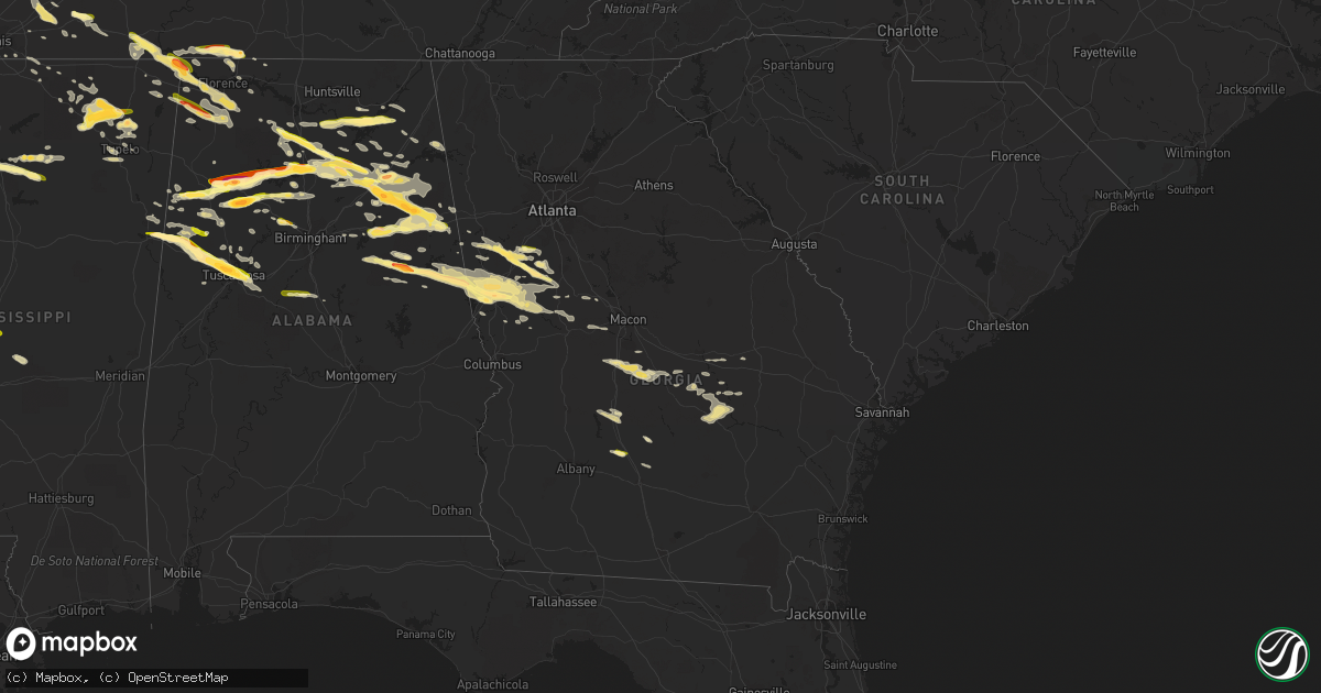
Hail Map in Georgia on March 31, 2015
Get this storm
March 31 map
$229
one time, instant access
Download today. No call, no setup
Keep the $229
Bought the map and want the full workflow? Apply the entire $229 to a subscription within 7 days. None of it is wasted.
Every map, not just this one
This buys you this map. Subscription and you get every map we run, in the markets you choose from a few cities to whole states to nationwide. Plus real-time alerts the moment a storm fires.
Contact data
Name, contact info, occupancy, even credit band for addresses in the footprint. You go from where it hit to who to call.
Become the source they trust
Unlimited branding weather history reports on demand. You already have the documented answer ready for the property owner, and you are the one who showed up with it.
Property data and RoofTrace estimates
Pull up any address you have got, its value and the exact code rules for that jurisdiction, straight from One Click Code. Then RoofTrace estimates the squares, pitch, and roof value, priced the way you price.
Storm reports in Georgia
Georgia
| Date | Description |
|---|---|
| 03/31/20156:52 PM CDT | Several trees were blown down in pike county. |
| 03/31/20156:39 PM CDT | Pea to quarter sized hail just north of higdon. |
| 03/31/20156:05 PM CDT | Public report of golf ball sized hail on ridley avenue. |
| 03/31/20155:52 PM CDT | Quarter sized hail fell. |
| 03/31/20155:45 PM CDT | Quarter to half dollar sized hail in senoia. Relayed to nws ffc from nws gsp. |
| 03/31/20155:37 PM CDT | Pea to quarter size hail in north peachtree city between 634 and 637pm. |
| 03/31/20155:37 PM CDT | Quarter size hail. |
| 03/31/20155:32 PM CDT | Hail of all sizes fell. Largest was ping pong ball sized. |
| 03/31/20155:30 PM CDT | Nickel to quarter size hail along hwy 16 between newnan and turin. |
| 03/31/20155:22 PM CDT | Quarter size hail reported in newnan. Report from social media. |
| 03/31/20154:19 PM CDT | Nickel to quarter size hail reported across northwestern ben hill county. |
| 03/31/20154:10 PM CDT | Hail mostly covers the ground. |
| 03/31/20153:15 PM CDT | Quarter size hail. Report came from social media. |
| 03/31/20152:56 PM CDT | A local report indicates 1.00 inch wind near 2 SW LAGRANGE |
| 03/30/201511:49 PM CDT | Numerous trees down in and around vidalia |
| 03/30/201510:39 PM CDT | Three trees blown down across tibet road near king road. Time estimated based on radar. |
| 03/30/201510:32 PM CDT | Tree down at bobtown road and tibet road. Time estimated based on radar. |
| 03/30/20159:55 PM CDT | Tree blown down on a car and numerous trees snapped near highway 121 at pineview baptist church. Trees blocking thomas lane. Time estimated based on radar. |
| 03/30/20159:54 PM CDT | Metal roof blown off of large chicken coop at the end of george mcleod rd. Time estimated from radar |
| 03/30/20159:45 PM CDT | Multiple trees down and damage to property near the corner of pinegrove ch rd and highway 23. Time estimed from radar |
| 03/30/20159:35 PM CDT | A couple of trees reported down near joe hester road. Time estimated from radar. |
| 03/30/20159:30 PM CDT | Several trees were blown down in toombs county. |
| 03/30/20159:15 PM CDT | Several trees and powerlines were blown down across wheeler county. |
| 03/30/20158:45 PM CDT | A tree was blown down onto abbeville highway. Power outages also reported in eastman. |
| 03/30/20158:25 PM CDT | A tree was blown down in plainfield. |
| 03/30/20157:06 PM CDT | Large tree blown down on pea ridge road near i-475 |
| 03/30/20157:03 PM CDT | Trees down on triune mill road near edna circle. Crews working an accident with 2 possible injuries. |
All States Impacted by Hail Map on March 31, 2015
Cities Impacted by Hail Map on March 31, 2015
- Senoia, GA
- Sharpsburg, GA
- Florence, AL
- Killen, AL
- Wynnewood, OK
- Pauls Valley, OK
- Davis, OK
- Sulphur, OK
- Stratford, OK
- Roff, OK
- Oakman, AL
- Northport, AL
- Wadley, AL
- Daviston, AL
- Checotah, OK
- Eufaula, OK
- Iron City, TN
- Cypress Inn, TN
- Isola, MS
- Belzoni, MS
- Rochelle, GA
- Jefferson, AR
- Sherrill, AR
- White Hall, AR
- Butler, OK
- Clinton, OK
- Bellevue, TX
- Greenville, GA
- Lagrange, GA
- Marmaduke, AR
- Rector, AR
- Canadian, TX
- Russellville, AL
- Cherokee, AL
- Weatherford, TX
- Saint Joseph, TN
- Blue Springs, MS
- Ripley, MS
- Booneville, MS
- Baldwyn, MS
- Guntown, MS
- Dumas, MS
- New Albany, MS
- Blue Mountain, MS
- Greenbrier, AR
- Quitman, AR
- Damascus, AR
- Attalla, AL
- Holly Grove, AR
- Elaine, AR
- Clarksdale, MS
- Alligator, MS
- Duncan, MS
- Mellwood, AR
- Perry, OK
- Boley, OK
- Castle, OK
- Okemah, OK
- Anadarko, OK
- Gracemont, OK
- Porum, OK
- Nauvoo, AL
- Guntersville, AL
- Langston, AL
- Groveoak, AL
- Scottsboro, AL
- Section, AL
- Grant, AL
- New Hope, AL
- Bolivar, TN
- Whiteville, TN
- Selmer, TN
- Bernie, MO
- Hawkinsville, GA
- Kathleen, GA
- Cochran, GA
- Perry, GA
- Fort Valley, GA
- Erick, OK
- Jacksonville, AR
- Vilonia, AR
- Little Rock Air Force Base, AR
- Cabot, AR
- Moreland, GA
- Brooks, GA
- Gay, GA
- Carrollton, GA
- Newnan, GA
- Williamson, GA
- Earlsboro, OK
- Sasakwa, OK
- Tecumseh, OK
- Maud, OK
- Holdenville, OK
- Wewoka, OK
- Bowlegs, OK
- Seminole, OK
- Ashburn, GA
- Hogansville, GA
- Okarche, OK
- Kingfisher, OK
- Wabbaseka, AR
- Altheimer, AR
- Eads, TN
- Saltillo, MS
- Atoka, OK
- Blountsville, AL
- Hayden, AL
- Walters, OK
- Eldorado, OK
- Gould, OK
- Shiloh, TN
- Michie, TN
- Alamo, GA
- Glenwood, GA
- Gaylesville, AL
- Watson, AR
- Bethany, OK
- Oklahoma City, OK
- Centre, AL
- Gordo, AL
- England, AR
- Hensley, AR
- Redfield, AR
- Bee Branch, AR
- Banner, MS
- Winfield, AL
- Double Springs, AL
- Eldridge, AL
- Carbon Hill, AL
- Arley, AL
- Jasper, AL
- Lynn, AL
- Crane Hill, AL
- Townley, AL
- Millport, AL
- Ethelsville, AL
- Reform, AL
- Steens, MS
- Columbus, MS
- Woodbury, GA
- Meeker, OK
- Shawnee, OK
- Altoona, AL
- Oneonta, AL
- Union Grove, AL
- Fyffe, AL
- Somerville, AL
- Huntsville, AL
- Laceys Spring, AL
- Gillett, AR
- Tichnor, AR
- Stuttgart, AR
- Gould, AR
- Fayette, AL
- Fort Sill, OK
- Lawton, OK
- Elgin, OK
- Trumann, AR
- Harrisburg, AR
- Oakland, MS
- Warrior, AL
- Leedey, OK
- Hammon, OK
- Berry, AL
- Edmond, OK
- Alicia, AR
- Cache, OK
- Woodville, AL
- Childress, TX
- Mabelvale, AR
- Alexander, AR
- Bryant, AR
- Benton, AR
- Watonga, OK
- Yazoo City, MS
- Vaughan, MS
- Benton, MS
- Soperton, GA
- Hector, AR
- Witts Springs, AR
- Marshall, AR
- Tilly, AR
- Cullman, AL
- Hanceville, AL
- Fisk, MO
- Poplar Bluff, MO
- Broseley, MO
- Collinsville, AL
- Crossville, AL
- Boaz, AL
- Vinemont, AL
- Danville, AL
- Ryan, OK
- Caney, OK
- Lane, OK
- Guin, AL
- Beaverton, AL
- Sulligent, AL
- Ashland, AL
- Ridgely, TN
- Sweetwater, TX
- Cordova, AL
- Parrish, AL
- Newport, AR
- Amagon, AR
- Morton, MS
- Lena, MS
- Greenville, MS
- Indianola, MS
- Hollandale, MS
- Leland, MS
- Shannon, MS
- Tupelo, MS
- Holly Pond, AL
- Horton, AL
- Cleveland, AL
- Clinton, AR
- Loyal, OK
- Paden, OK
- Hayti, MO
- Geronimo, OK
- Echola, AL
- Buhl, AL
- Coker, AL
- Tuscaloosa, AL
- Cottondale, AL
- Elrod, AL
- Crumrod, AR
- Quanah, TX
- Heflin, AL
- Anniston, AL
- Oxford, AL
- Water Valley, MS
- Shidler, OK
- Mcloud, OK
- Forsyth, GA
- Benoit, MS
- Shaw, MS
- Rohwer, AR
- Mustang, OK
- Yukon, OK
- Wheatland, OK
- Halls, TN
- Earle, AR
- Crawfordsville, AR
- Hinton, OK
- Ashville, AL
- Rainbow City, AL
- Ohatchee, AL
- Gadsden, AL
- Calumet, OK
- Lineville, AL
- Montevallo, AL
- Brierfield, AL
- Piggott, AR
- Crescent, OK
- Marshall, OK
- Foss, OK
- Arapaho, OK
- Corn, OK
- Weatherford, OK
- Hydro, OK
- Lookeba, OK
- Custer City, OK
- Parma, MO
- Dexter, MO
- Bankston, AL
- Prague, OK
- Kaw City, OK
- Ponca City, OK
- McRae Helena, GA
- Weaver, AL
- Lincoln, AL
- Piedmont, AL
- Wellington, AL
- Steele, AL
- Talladega, AL
- Falkville, AL
- Alexandria, AL
- Jacksonville, AL
- Munford, AL
- Gallant, AL
- Brilliant, AL
- Pell City, AL
- Logan, AL
- Eastaboga, AL
- Hartselle, AL
- Bremen, AL
- Hennessey, OK
- Catron, MO
- Luthersville, GA
- Grantville, GA
- Copan, OK
- Scotland, AR
- Center Ridge, AR
- Weiner, AR
- Cash, AR
- Binger, OK
- El Reno, OK
- Minco, OK
- Union City, OK
- Stigler, OK
- Ailey, GA
- Mount Vernon, GA
- Enola, AR
- Tuscumbia, AL
- Luther, OK
- Ada, OK
- Peachtree City, GA
- Iowa Park, TX
- Albertville, AL
- Council Hill, OK
- Fort Cobb, OK
- Roanoke, AL
- Stanton, TN
- Somerville, TN
- Mason, TN
- Conway, AR
- Beulah, MS
- Humphrey, AR
- Dumas, AR
- Tchula, MS
- Moorhead, MS
- Silver City, MS
- Inverness, MS
- Itta Bena, MS
- De Witt, AR
- Tillar, AR
- Cleveland, MS
- Canton, MS
- Vienna, GA
- Empire, AL
- Sayre, OK
- Carter, OK
- Tutwiler, MS
- Clarendon, AR
- Lamar, MS
- Quinton, AL
- Dora, AL
- Franklin, GA
- Wedowee, AL
- Cragford, AL
- Stantonville, TN
- Lexington, OK
- Macomb, OK
- Wanette, OK
- Noble, OK
- Indiahoma, OK
- Graysville, AL
- Adamsville, AL
- Guys, TN
- Ramer, TN
- Hollister, OK
- Frederick, OK
- Bartlesville, OK
- Asher, OK
- Belden, MS
- Harrah, OK
- Rose Bud, AR
- Mount Vernon, AR
- Brookwood, AL
- Lindsay, OK
- Counce, TN
- Leighton, AL
- Iuka, MS
- Corinth, MS
- Sheffield, AL
- Savannah, TN
- Waterloo, AL
- Town Creek, AL
- Cordele, GA
- Crowell, TX
- Coffeeville, MS
- Chillicothe, TX
- Chandler, OK
- Hitchcock, OK
- Okeene, OK
- Lutts, TN
- Westpoint, TN
- Loretto, TN
- Tishomingo, MS
- Burnsville, MS
- Vernon, TX
- Thomaston, GA
- Yatesville, GA
- Lexington, AL
- Potts Camp, MS
- Hickory Flat, MS
- Hollis, OK
- Calera, AL
- Osceola, AR
- Henning, TN
- Ripley, TN
- Covington, TN
- Higgins, TX
- Musella, GA
- Knoxville, GA
- Lizella, GA
- Enid, MS
- Gepp, AR
- Five Points, AL
- Calico Rock, AR
- Choctaw, OK
- Jones, OK
- Allen, OK
- Red Bay, AL
- Vina, AL
- Tucker, AR
- Little Rock, AR
- Saint Charles, AR
- Meridian, OK
- Guthrie, OK
- Warm Springs, GA
- Manchester, GA
- Shiloh, GA
- Arab, AL
- Finley, TN
- Morris, OK
- Boynton, OK
- Barnesville, GA
- Dutton, AL
- Rainsville, AL
- Cherry Valley, AR
- Horseshoe Bend, AR
- Evening Shade, AR
- Sidney, AR
- Newalla, OK
- Norman, OK
- Parkin, AR
- Fisher, AR
- Apache, OK
- Adrian, GA
- Rockledge, GA
- East Dublin, GA
- Konawa, OK
- Alpine, AL
- Molena, GA
- Byhalia, MS
- Holly Springs, MS
- Rossville, TN
- Collierville, TN
- Haleyville, AL
- Bear Creek, AL
- Leesburg, AL
- Myrtle, MS
- Tupelo, OK
- Fort Payne, AL
- Sage, AR
- Melbourne, AR
- Franklin, AR
- Coalgate, OK
- Arcadia, OK
- Poughkeepsie, AR
- Swifton, AR
- Bowdon, GA
- Dexter, GA
- Chester, GA
- Oakland, TN
- Concord, GA
- Roopville, GA
- Whitesburg, GA
- Leslie, AR
- Cleveland, AR
- Red Banks, MS
- Paron, AR
- Dublin, GA
- Cadwell, GA
- Rentz, GA
- Ragland, AL
- Vernon, AL
- Ranburne, AL
- Eva, AL
- Moulton, AL
- Houston, AL
- Baileyton, AL
- Paducah, TX
- Almyra, AR
- Mooreville, MS
- Lexington, MS
- Wann, OK
- Coffeyville, KS
- Dawson, AL
- Elk City, OK
- Duncan, OK
- Goodwater, AL
- Millerville, AL
- Oxford, MS
- Orlando, OK
- West Point, GA
- Delta, AL
- Marston, MO
- Pickens, MS
- Caddo, OK
- Jemison, AL
- Marland, OK
- Salem, AR
- Cheyenne, OK
- Caledonia, MS
- Hamilton, MS
- Fitzhugh, OK
- Lafe, AR
- Davidson, OK
- Woodland, GA
- Kennedy, AL
- Zebulon, GA
- Fayetteville, GA
- Riverside, AL
- Stonewall, OK
- Paris, MS
- Holcomb, MO
- Kennett, MO
- Pine Mountain, GA
- Rush Springs, OK
- Griffin, GA
- Eutaw, AL
- Phil Campbell, AL
- Wellston, OK
- Dry Branch, GA
- Loveland, OK
- Swainsboro, GA
- Spencer, OK
- Memphis, TN
- Pope, MS
- Courtland, MS
- Anderson, AL
- Marlow, OK
- Cedar Bluff, AL
- Mantachie, MS
- Falkner, MS
- Ashland, MS
- Greenway, AR
- Bruce, MS
- Carnegie, OK
- Smithville, AR
- Centrahoma, OK
- Chickasha, OK
- Pocasset, OK
- Verden, OK
- Chula, GA
- Red Oak, OK
- Marion, AR
- Millington, TN
- Marked Tree, AR
- Muscadine, AL
- Tallapoosa, GA
- Duke, OK
- Canute, OK
- Henryetta, OK
- Fletcher, OK
- Talihina, OK
- Lumber City, GA
- Uvalda, GA
- Toone, TN
- Hornsby, TN
- Faxon, OK
- Coleman, OK
- Eastman, GA
- Quinton, OK
- Fruithurst, AL
- Hickory Valley, TN
- Doniphan, MO
- Woodland, AL
- Meansville, GA
- Cropwell, AL
- Glen, MS
- Tyrone, GA
- Sparks, OK
- Rosedale, MS
- Camden, MS
- Guy, AR
- Drew, MS
- Bethel Springs, TN


