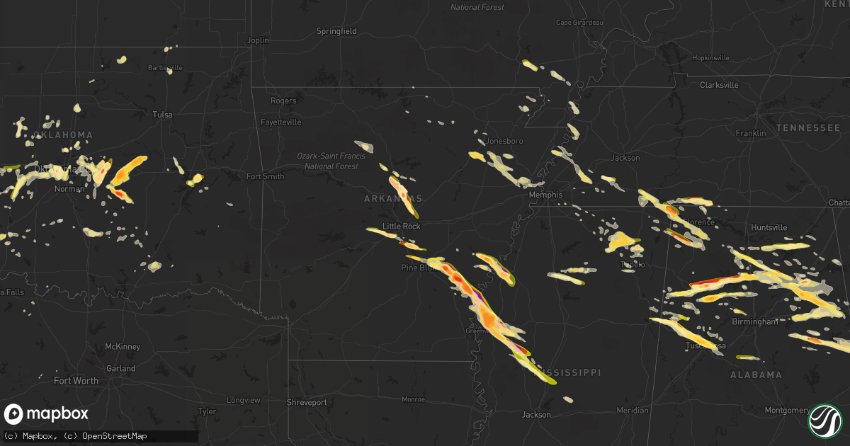
Hail Map in Arkansas on March 31, 2015
Get this storm
March 31 map
$229
one time, instant access
Download today. No call, no setup
Keep the $229
Bought the map and want the full workflow? Apply the entire $229 to a subscription within 7 days. None of it is wasted.
Every map, not just this one
This buys you this map. Subscription and you get every map we run, in the markets you choose from a few cities to whole states to nationwide. Plus real-time alerts the moment a storm fires.
Contact data
Name, contact info, occupancy, even credit band for addresses in the footprint. You go from where it hit to who to call.
Become the source they trust
Unlimited branding weather history reports on demand. You already have the documented answer ready for the property owner, and you are the one who showed up with it.
Property data and RoofTrace estimates
Pull up any address you have got, its value and the exact code rules for that jurisdiction, straight from One Click Code. Then RoofTrace estimates the squares, pitch, and roof value, priced the way you price.
Storm reports in Arkansas
Arkansas
| Date | Description |
|---|---|
| 03/31/20156:50 PM CDT | A local report indicates 1.00 inch wind near GUY |
| 03/31/20155:45 PM CDT | Dime to quarter size hail near rector. |
| 03/31/20153:28 PM CDT | Golf ball size hail in lambrook... Ar. |
| 03/31/20153:15 PM CDT | A local report indicates a tornado near WATSON |
| 03/31/20153:15 PM CDT | A local report indicates 70 MPH wind near PENDLETON |
| 03/31/20153:00 PM CDT | A local report indicates a tornado near 11 NE DUMAS |
| 03/31/20152:57 PM CDT | Shingles were blown of roofs. |
| 03/31/20152:57 PM CDT | A local report indicates 1.75 inch wind near ARKANSAS POST |
| 03/31/20152:55 PM CDT | A local report indicates 1.00 inch wind near 1 N ARKANSAS POST |
| 03/31/20152:55 PM CDT | A shed was blown across a field along with pieces of tin. |
| 03/31/20152:50 PM CDT | A local report indicates a tornado near 6 S GILLETT |
| 03/31/20152:50 PM CDT | One side of mobile home was off. |
| 03/31/20152:48 PM CDT | A local report indicates 2.75 inch wind near 3 S GILLETT |
| 03/31/20152:40 PM CDT | A local report indicates a tornado near 7 SW GILLETT |
| 03/31/20152:34 PM CDT | A local report indicates 2.75 inch wind near YANCOPIN |
| 03/31/20152:20 PM CDT | A local report indicates 2.50 inch wind near 4 NNW REYDELL |
| 03/31/20151:55 PM CDT | A local report indicates 1.00 inch wind near PINE BLUFF ARSENAL |
| 03/31/20151:35 PM CDT | A local report indicates 1.00 inch wind near ALTHEIMER |
| 03/31/20151:10 PM CDT | A local report indicates 2.00 inch wind near 4 NE REDFIELD |
| 03/31/20151:01 PM CDT | A local report indicates 1.75 inch wind near WOODSON |
| 03/31/201512:35 PM CDT | A local report indicates 1.50 inch wind near SHANNON HILLS |
| 03/31/201512:32 PM CDT | Hail covering roadway. |
| 03/31/201512:25 PM CDT | A local report indicates 1.75 inch wind near ALEXANDER |
| 03/31/201512:23 PM CDT | Near exit 123 of interstate 30. |
| 03/31/201512:10 PM CDT | A local report indicates 1.50 inch wind near AVILLA |
| 03/31/201511:50 AM CDT | A local report indicates 1.00 inch wind near BLAND |
| 03/31/201512:40 AM CDT | Nickel to quarter size hail near highways 64 and 149. |
| 03/30/201510:15 PM CDT | Ping pong size hail near whitehall |
| 03/30/201510:14 PM CDT | Quarter size hail near weiner. |
| 03/30/20159:50 PM CDT | A local report indicates 1.75 inch wind near 2 W GRUBBS |
| 03/30/20159:39 PM CDT | A local report indicates 1.25 inch wind near 2 NE MACON |
| 03/30/20159:36 PM CDT | Hail fell near the back gate of the base along hwy 107. |
| 03/30/20159:16 PM CDT | A local report indicates 1.00 inch wind near VILONIA |
| 03/30/20158:55 PM CDT | Hail was estimated to be between 2 to 2.25 inches. |
| 03/30/20158:35 PM CDT | A local report indicates 3.00 inch wind near 3 N GREENBRIER |
| 03/30/20158:15 PM CDT | A local report indicates 2.00 inch wind near 2 N TWIN GROVES |
| 03/30/20158:12 PM CDT | A local report indicates 1.25 inch wind near 3 NW TWIN GROVES |
All States Impacted by Hail Map on March 31, 2015
Cities Impacted by Hail Map on March 31, 2015
- Senoia, GA
- Sharpsburg, GA
- Florence, AL
- Killen, AL
- Wynnewood, OK
- Pauls Valley, OK
- Davis, OK
- Sulphur, OK
- Stratford, OK
- Roff, OK
- Oakman, AL
- Northport, AL
- Wadley, AL
- Daviston, AL
- Checotah, OK
- Eufaula, OK
- Iron City, TN
- Cypress Inn, TN
- Isola, MS
- Belzoni, MS
- Rochelle, GA
- Jefferson, AR
- Sherrill, AR
- White Hall, AR
- Butler, OK
- Clinton, OK
- Bellevue, TX
- Greenville, GA
- Lagrange, GA
- Marmaduke, AR
- Rector, AR
- Canadian, TX
- Russellville, AL
- Cherokee, AL
- Weatherford, TX
- Saint Joseph, TN
- Blue Springs, MS
- Ripley, MS
- Booneville, MS
- Baldwyn, MS
- Guntown, MS
- Dumas, MS
- New Albany, MS
- Blue Mountain, MS
- Greenbrier, AR
- Quitman, AR
- Damascus, AR
- Attalla, AL
- Holly Grove, AR
- Elaine, AR
- Clarksdale, MS
- Alligator, MS
- Duncan, MS
- Mellwood, AR
- Perry, OK
- Boley, OK
- Castle, OK
- Okemah, OK
- Anadarko, OK
- Gracemont, OK
- Porum, OK
- Nauvoo, AL
- Guntersville, AL
- Langston, AL
- Groveoak, AL
- Scottsboro, AL
- Section, AL
- Grant, AL
- New Hope, AL
- Bolivar, TN
- Whiteville, TN
- Selmer, TN
- Bernie, MO
- Hawkinsville, GA
- Kathleen, GA
- Cochran, GA
- Perry, GA
- Fort Valley, GA
- Erick, OK
- Jacksonville, AR
- Vilonia, AR
- Little Rock Air Force Base, AR
- Cabot, AR
- Moreland, GA
- Brooks, GA
- Gay, GA
- Carrollton, GA
- Newnan, GA
- Williamson, GA
- Earlsboro, OK
- Sasakwa, OK
- Tecumseh, OK
- Maud, OK
- Holdenville, OK
- Wewoka, OK
- Bowlegs, OK
- Seminole, OK
- Ashburn, GA
- Hogansville, GA
- Okarche, OK
- Kingfisher, OK
- Wabbaseka, AR
- Altheimer, AR
- Eads, TN
- Saltillo, MS
- Atoka, OK
- Blountsville, AL
- Hayden, AL
- Walters, OK
- Eldorado, OK
- Gould, OK
- Shiloh, TN
- Michie, TN
- Alamo, GA
- Glenwood, GA
- Gaylesville, AL
- Watson, AR
- Bethany, OK
- Oklahoma City, OK
- Centre, AL
- Gordo, AL
- England, AR
- Hensley, AR
- Redfield, AR
- Bee Branch, AR
- Banner, MS
- Winfield, AL
- Double Springs, AL
- Eldridge, AL
- Carbon Hill, AL
- Arley, AL
- Jasper, AL
- Lynn, AL
- Crane Hill, AL
- Townley, AL
- Millport, AL
- Ethelsville, AL
- Reform, AL
- Steens, MS
- Columbus, MS
- Woodbury, GA
- Meeker, OK
- Shawnee, OK
- Altoona, AL
- Oneonta, AL
- Union Grove, AL
- Fyffe, AL
- Somerville, AL
- Huntsville, AL
- Laceys Spring, AL
- Gillett, AR
- Tichnor, AR
- Stuttgart, AR
- Gould, AR
- Fayette, AL
- Fort Sill, OK
- Lawton, OK
- Elgin, OK
- Trumann, AR
- Harrisburg, AR
- Oakland, MS
- Warrior, AL
- Leedey, OK
- Hammon, OK
- Berry, AL
- Edmond, OK
- Alicia, AR
- Cache, OK
- Woodville, AL
- Childress, TX
- Mabelvale, AR
- Alexander, AR
- Bryant, AR
- Benton, AR
- Watonga, OK
- Yazoo City, MS
- Vaughan, MS
- Benton, MS
- Soperton, GA
- Hector, AR
- Witts Springs, AR
- Marshall, AR
- Tilly, AR
- Cullman, AL
- Hanceville, AL
- Fisk, MO
- Poplar Bluff, MO
- Broseley, MO
- Collinsville, AL
- Crossville, AL
- Boaz, AL
- Vinemont, AL
- Danville, AL
- Ryan, OK
- Caney, OK
- Lane, OK
- Guin, AL
- Beaverton, AL
- Sulligent, AL
- Ashland, AL
- Ridgely, TN
- Sweetwater, TX
- Cordova, AL
- Parrish, AL
- Newport, AR
- Amagon, AR
- Morton, MS
- Lena, MS
- Greenville, MS
- Indianola, MS
- Hollandale, MS
- Leland, MS
- Shannon, MS
- Tupelo, MS
- Holly Pond, AL
- Horton, AL
- Cleveland, AL
- Clinton, AR
- Loyal, OK
- Paden, OK
- Hayti, MO
- Geronimo, OK
- Echola, AL
- Buhl, AL
- Coker, AL
- Tuscaloosa, AL
- Cottondale, AL
- Elrod, AL
- Crumrod, AR
- Quanah, TX
- Heflin, AL
- Anniston, AL
- Oxford, AL
- Water Valley, MS
- Shidler, OK
- Mcloud, OK
- Forsyth, GA
- Benoit, MS
- Shaw, MS
- Rohwer, AR
- Mustang, OK
- Yukon, OK
- Wheatland, OK
- Halls, TN
- Earle, AR
- Crawfordsville, AR
- Hinton, OK
- Ashville, AL
- Rainbow City, AL
- Ohatchee, AL
- Gadsden, AL
- Calumet, OK
- Lineville, AL
- Montevallo, AL
- Brierfield, AL
- Piggott, AR
- Crescent, OK
- Marshall, OK
- Foss, OK
- Arapaho, OK
- Corn, OK
- Weatherford, OK
- Hydro, OK
- Lookeba, OK
- Custer City, OK
- Parma, MO
- Dexter, MO
- Bankston, AL
- Prague, OK
- Kaw City, OK
- Ponca City, OK
- McRae Helena, GA
- Weaver, AL
- Lincoln, AL
- Piedmont, AL
- Wellington, AL
- Steele, AL
- Talladega, AL
- Falkville, AL
- Alexandria, AL
- Jacksonville, AL
- Munford, AL
- Gallant, AL
- Brilliant, AL
- Pell City, AL
- Logan, AL
- Eastaboga, AL
- Hartselle, AL
- Bremen, AL
- Hennessey, OK
- Catron, MO
- Luthersville, GA
- Grantville, GA
- Copan, OK
- Scotland, AR
- Center Ridge, AR
- Weiner, AR
- Cash, AR
- Binger, OK
- El Reno, OK
- Minco, OK
- Union City, OK
- Stigler, OK
- Ailey, GA
- Mount Vernon, GA
- Enola, AR
- Tuscumbia, AL
- Luther, OK
- Ada, OK
- Peachtree City, GA
- Iowa Park, TX
- Albertville, AL
- Council Hill, OK
- Fort Cobb, OK
- Roanoke, AL
- Stanton, TN
- Somerville, TN
- Mason, TN
- Conway, AR
- Beulah, MS
- Humphrey, AR
- Dumas, AR
- Tchula, MS
- Moorhead, MS
- Silver City, MS
- Inverness, MS
- Itta Bena, MS
- De Witt, AR
- Tillar, AR
- Cleveland, MS
- Canton, MS
- Vienna, GA
- Empire, AL
- Sayre, OK
- Carter, OK
- Tutwiler, MS
- Clarendon, AR
- Lamar, MS
- Quinton, AL
- Dora, AL
- Franklin, GA
- Wedowee, AL
- Cragford, AL
- Stantonville, TN
- Lexington, OK
- Macomb, OK
- Wanette, OK
- Noble, OK
- Indiahoma, OK
- Graysville, AL
- Adamsville, AL
- Guys, TN
- Ramer, TN
- Hollister, OK
- Frederick, OK
- Bartlesville, OK
- Asher, OK
- Belden, MS
- Harrah, OK
- Rose Bud, AR
- Mount Vernon, AR
- Brookwood, AL
- Lindsay, OK
- Counce, TN
- Leighton, AL
- Iuka, MS
- Corinth, MS
- Sheffield, AL
- Savannah, TN
- Waterloo, AL
- Town Creek, AL
- Cordele, GA
- Crowell, TX
- Coffeeville, MS
- Chillicothe, TX
- Chandler, OK
- Hitchcock, OK
- Okeene, OK
- Lutts, TN
- Westpoint, TN
- Loretto, TN
- Tishomingo, MS
- Burnsville, MS
- Vernon, TX
- Thomaston, GA
- Yatesville, GA
- Lexington, AL
- Potts Camp, MS
- Hickory Flat, MS
- Hollis, OK
- Calera, AL
- Osceola, AR
- Henning, TN
- Ripley, TN
- Covington, TN
- Higgins, TX
- Musella, GA
- Knoxville, GA
- Lizella, GA
- Enid, MS
- Gepp, AR
- Five Points, AL
- Calico Rock, AR
- Choctaw, OK
- Jones, OK
- Allen, OK
- Red Bay, AL
- Vina, AL
- Tucker, AR
- Little Rock, AR
- Saint Charles, AR
- Meridian, OK
- Guthrie, OK
- Warm Springs, GA
- Manchester, GA
- Shiloh, GA
- Arab, AL
- Finley, TN
- Morris, OK
- Boynton, OK
- Barnesville, GA
- Dutton, AL
- Rainsville, AL
- Cherry Valley, AR
- Horseshoe Bend, AR
- Evening Shade, AR
- Sidney, AR
- Newalla, OK
- Norman, OK
- Parkin, AR
- Fisher, AR
- Apache, OK
- Adrian, GA
- Rockledge, GA
- East Dublin, GA
- Konawa, OK
- Alpine, AL
- Molena, GA
- Byhalia, MS
- Holly Springs, MS
- Rossville, TN
- Collierville, TN
- Haleyville, AL
- Bear Creek, AL
- Leesburg, AL
- Myrtle, MS
- Tupelo, OK
- Fort Payne, AL
- Sage, AR
- Melbourne, AR
- Franklin, AR
- Coalgate, OK
- Arcadia, OK
- Poughkeepsie, AR
- Swifton, AR
- Bowdon, GA
- Dexter, GA
- Chester, GA
- Oakland, TN
- Concord, GA
- Roopville, GA
- Whitesburg, GA
- Leslie, AR
- Cleveland, AR
- Red Banks, MS
- Paron, AR
- Dublin, GA
- Cadwell, GA
- Rentz, GA
- Ragland, AL
- Vernon, AL
- Ranburne, AL
- Eva, AL
- Moulton, AL
- Houston, AL
- Baileyton, AL
- Paducah, TX
- Almyra, AR
- Mooreville, MS
- Lexington, MS
- Wann, OK
- Coffeyville, KS
- Dawson, AL
- Elk City, OK
- Duncan, OK
- Goodwater, AL
- Millerville, AL
- Oxford, MS
- Orlando, OK
- West Point, GA
- Delta, AL
- Marston, MO
- Pickens, MS
- Caddo, OK
- Jemison, AL
- Marland, OK
- Salem, AR
- Cheyenne, OK
- Caledonia, MS
- Hamilton, MS
- Fitzhugh, OK
- Lafe, AR
- Davidson, OK
- Woodland, GA
- Kennedy, AL
- Zebulon, GA
- Fayetteville, GA
- Riverside, AL
- Stonewall, OK
- Paris, MS
- Holcomb, MO
- Kennett, MO
- Pine Mountain, GA
- Rush Springs, OK
- Griffin, GA
- Eutaw, AL
- Phil Campbell, AL
- Wellston, OK
- Dry Branch, GA
- Loveland, OK
- Swainsboro, GA
- Spencer, OK
- Memphis, TN
- Pope, MS
- Courtland, MS
- Anderson, AL
- Marlow, OK
- Cedar Bluff, AL
- Mantachie, MS
- Falkner, MS
- Ashland, MS
- Greenway, AR
- Bruce, MS
- Carnegie, OK
- Smithville, AR
- Centrahoma, OK
- Chickasha, OK
- Pocasset, OK
- Verden, OK
- Chula, GA
- Red Oak, OK
- Marion, AR
- Millington, TN
- Marked Tree, AR
- Muscadine, AL
- Tallapoosa, GA
- Duke, OK
- Canute, OK
- Henryetta, OK
- Fletcher, OK
- Talihina, OK
- Lumber City, GA
- Uvalda, GA
- Toone, TN
- Hornsby, TN
- Faxon, OK
- Coleman, OK
- Eastman, GA
- Quinton, OK
- Fruithurst, AL
- Hickory Valley, TN
- Doniphan, MO
- Woodland, AL
- Meansville, GA
- Cropwell, AL
- Glen, MS
- Tyrone, GA
- Sparks, OK
- Rosedale, MS
- Camden, MS
- Guy, AR
- Drew, MS
- Bethel Springs, TN


