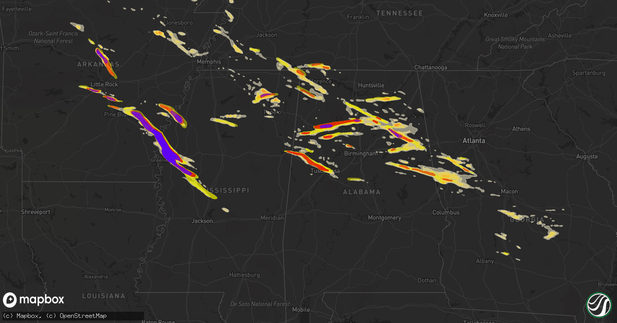
Hail Map on March 31, 2015
Get this storm
March 31 map
$229
one time, instant access
Download today. No call, no setup
Keep the $229
Bought the map and want the full workflow? Apply the entire $229 to a subscription within 7 days. None of it is wasted.
Every map, not just this one
This buys you this map. Subscription and you get every map we run, in the markets you choose from a few cities to whole states to nationwide. Plus real-time alerts the moment a storm fires.
Contact data
Name, contact info, occupancy, even credit band for addresses in the footprint. You go from where it hit to who to call.
Become the source they trust
Unlimited branding weather history reports on demand. You already have the documented answer ready for the property owner, and you are the one who showed up with it.
Property data and RoofTrace estimates
Pull up any address you have got, its value and the exact code rules for that jurisdiction, straight from One Click Code. Then RoofTrace estimates the squares, pitch, and roof value, priced the way you price.
States Impacted by Hail Map on March 31, 2015
Storm reports
Tennessee
| Date | Description |
|---|---|
| 03/31/20156:25 PM CDT | Quarter to golf ball hail. Highway 43 at st. Joseph is covered in hail. |
| 03/31/20156:18 PM CDT | Half dollar size hail in selmer |
| 03/30/20157:32 PM CDT | Twitter picture of hail larger than a quarter. Time and location approximated by radar. |
| 03/30/20157:28 PM CDT | A local report indicates 1.00 inch wind near ST. JOSEPH |
Missouri
| Date | Description |
|---|---|
| 03/31/20154:12 PM CDT | A local report indicates 1.25 inch wind near 2 E POPLAR BLUFF |
| 03/30/20159:27 PM CDT | Large tree limbs down in hollywood. |
Oklahoma
| Date | Description |
|---|---|
| 03/31/20156:25 PM CDT | A local report indicates 1.00 inch wind near 9 NNE HOLLIS |
| 03/31/20156:25 PM CDT | A local report indicates 1.25 inch wind near 6 N MCKNIGHT |
| 03/31/20156:02 PM CDT | A local report indicates 1.00 inch wind near 8 NE RED OAK |
| 03/31/20152:45 PM CDT | 12 inch diameter tree snapped in half. |
| 03/31/201511:55 AM CDT | A local report indicates 67 MPH wind near 6 N OKLAHOMA CITY |
| 03/31/20153:40 AM CDT | A local report indicates 1.25 inch wind near 8 ESE BARTLESVILLE |
| 03/31/20151:50 AM CDT | Trees snapped or uprooted. |
| 03/31/20151:05 AM CDT | A local report indicates 60 MPH wind near PRAGUE |
| 03/31/201512:31 AM CDT | Trees and powerlines down at nw 8th and western. |
| 03/31/201512:30 AM CDT | Trees snapped or uprooted |
| 03/31/201512:28 AM CDT | Large tree down on road blocking both lanes of traffic. |
| 03/31/201512:20 AM CDT | A local report indicates 60 MPH wind near PAULS VALLEY |
| 03/31/201512:02 AM CDT | A local report indicates 1.75 inch wind near 4 NE MUSTANG |
| 03/31/201512:02 AM CDT | A local report indicates 1.75 inch wind near 6 NE MUSTANG |
| 03/30/201511:50 PM CDT | A local report indicates 60 MPH wind near OKLAHOMA CITY |
| 03/30/201511:49 PM CDT | A local report indicates 68 MPH wind near OKLAHOMA CITY |
| 03/30/201511:36 PM CDT | A local report indicates 84 MPH wind near MUSTANG |
| 03/30/201511:35 PM CDT | Roof damage. |
| 03/30/201511:35 PM CDT | A local report indicates 63 MPH wind near YUKON |
| 03/30/201511:33 PM CDT | A local report indicates 82 MPH wind near MUSTANG |
| 03/30/201511:28 PM CDT | A local report indicates 72 MPH wind near MUSTANG |
| 03/30/201511:19 PM CDT | Trees down. |
| 03/30/201511:15 PM CDT | A local report indicates 1.00 inch wind near 4 S SEWARD |
| 03/30/201511:12 PM CDT | Winds estimated to 55 mph. |
| 03/30/201511:03 PM CDT | A local report indicates 2.75 inch wind near MEEKER |
| 03/30/201510:54 PM CDT | A local report indicates 1.00 inch wind near NW MIDWEST CITY |
| 03/30/201510:50 PM CDT | A local report indicates 1.50 inch wind near 8 S GUTHRIE |
| 03/30/201510:47 PM CDT | A local report indicates 1.50 inch wind near NE GRACEMONT |
| 03/30/201510:45 PM CDT | 12 inch diameter tree snapped in half. |
| 03/30/201510:45 PM CDT | A local report indicates 2.50 inch wind near 1 SE MEEKER |
| 03/30/201510:45 PM CDT | A local report indicates 1.25 inch wind near LAWTON |
| 03/30/201510:44 PM CDT | Measured at 29th and s. Independence |
| 03/30/201510:40 PM CDT | Small limbs and branches blown off trees. |
| 03/30/201510:40 PM CDT | Hail fell just east of pierce. Time estimated via radar. Relayed via broadcast media social media account. |
| 03/30/201510:40 PM CDT | A local report indicates 1.00 inch wind near HINTON |
| 03/30/201510:35 PM CDT | Trees snapped or uprooted. Estimated to 75 mph. |
| 03/30/201510:32 PM CDT | A local report indicates 1.25 inch wind near 18 WNW UNION CITY |
| 03/30/201510:30 PM CDT | A local report indicates 1.00 inch wind near 2 SSE VALLEY BROOK |
| 03/30/201510:30 PM CDT | A local report indicates 1.75 inch wind near SHAWNEE |
| 03/30/201510:30 PM CDT | Power poles down. |
| 03/30/201510:28 PM CDT | A local report indicates 60 MPH wind near LAWTON |
| 03/30/201510:25 PM CDT | A local report indicates 2.75 inch wind near SHAWNEE |
| 03/30/201510:24 PM CDT | A local report indicates 1.00 inch wind near MOORE |
| 03/30/201510:18 PM CDT | A local report indicates 1.25 inch wind near 5 SE SEMINOLE |
| 03/30/20159:48 PM CDT | A local report indicates 1.00 inch wind near CHATTANOOGA |
| 03/30/20159:30 PM CDT | A local report indicates 1.75 inch wind near 6 SW WARNER |
| 03/30/20159:26 PM CDT | A local report indicates 1.75 inch wind near 10 E EUFAULA |
| 03/30/20159:26 PM CDT | A local report indicates 2.50 inch wind near WELTY |
| 03/30/20159:25 PM CDT | Time is radar estimated |
| 03/30/20159:10 PM CDT | A local report indicates 1.75 inch wind near 2 S SEMINOLE |
| 03/30/20159:04 PM CDT | A local report indicates 1.75 inch wind near 3 S SEMINOLE |
| 03/30/20158:58 PM CDT | A local report indicates 2.75 inch wind near BOWLEGS |
| 03/30/20158:55 PM CDT | A local report indicates 1.00 inch wind near EUFAULA |
| 03/30/20158:53 PM CDT | A local report indicates 1.50 inch wind near 1 N BOWLEGS |
| 03/30/20158:46 PM CDT | Time is radar estimated |
| 03/30/20158:46 PM CDT | A local report indicates 1.75 inch wind near 2 N BOWLEGS |
| 03/30/20158:37 PM CDT | A local report indicates 1.75 inch wind near 1 W BUTLER |
| 03/30/20158:35 PM CDT | A local report indicates 1.00 inch wind near ELDORADO |
| 03/30/20158:31 PM CDT | A local report indicates 1.00 inch wind near 1 N ELDORADO |
| 03/30/20158:30 PM CDT | A local report indicates 2.75 inch wind near 2 N BOWLEGS |
| 03/30/20158:20 PM CDT | A local report indicates 1.00 inch wind near ELDORADO |
| 03/30/20158:17 PM CDT | A local report indicates 2.50 inch wind near 10 N SEMINOLE |
| 03/30/20158:10 PM CDT | A local report indicates 1.75 inch wind near 2 N LITTLE |
| 03/30/20158:04 PM CDT | A local report indicates 1.75 inch wind near 2 E ANGORA |
| 03/30/20157:51 PM CDT | A local report indicates 1.75 inch wind near 6 S ERICK |
| 03/30/20157:40 PM CDT | A local report indicates 1.00 inch wind near 1 S EARLSBORO |
Georgia
| Date | Description |
|---|---|
| 03/31/20156:52 PM CDT | Several trees were blown down in pike county. |
| 03/31/20156:39 PM CDT | Pea to quarter sized hail just north of higdon. |
| 03/31/20156:05 PM CDT | Public report of golf ball sized hail on ridley avenue. |
| 03/31/20155:52 PM CDT | Quarter sized hail fell. |
| 03/31/20155:45 PM CDT | Quarter to half dollar sized hail in senoia. Relayed to nws ffc from nws gsp. |
| 03/31/20155:37 PM CDT | Pea to quarter size hail in north peachtree city between 634 and 637pm. |
| 03/31/20155:37 PM CDT | Quarter size hail. |
| 03/31/20155:32 PM CDT | Hail of all sizes fell. Largest was ping pong ball sized. |
| 03/31/20155:30 PM CDT | Nickel to quarter size hail along hwy 16 between newnan and turin. |
| 03/31/20155:22 PM CDT | Quarter size hail reported in newnan. Report from social media. |
| 03/31/20154:19 PM CDT | Nickel to quarter size hail reported across northwestern ben hill county. |
| 03/31/20154:10 PM CDT | Hail mostly covers the ground. |
| 03/31/20153:15 PM CDT | Quarter size hail. Report came from social media. |
| 03/31/20152:56 PM CDT | A local report indicates 1.00 inch wind near 2 SW LAGRANGE |
| 03/30/201511:49 PM CDT | Numerous trees down in and around vidalia |
| 03/30/201510:39 PM CDT | Three trees blown down across tibet road near king road. Time estimated based on radar. |
| 03/30/201510:32 PM CDT | Tree down at bobtown road and tibet road. Time estimated based on radar. |
| 03/30/20159:55 PM CDT | Tree blown down on a car and numerous trees snapped near highway 121 at pineview baptist church. Trees blocking thomas lane. Time estimated based on radar. |
| 03/30/20159:54 PM CDT | Metal roof blown off of large chicken coop at the end of george mcleod rd. Time estimated from radar |
| 03/30/20159:45 PM CDT | Multiple trees down and damage to property near the corner of pinegrove ch rd and highway 23. Time estimed from radar |
| 03/30/20159:35 PM CDT | A couple of trees reported down near joe hester road. Time estimated from radar. |
| 03/30/20159:30 PM CDT | Several trees were blown down in toombs county. |
| 03/30/20159:15 PM CDT | Several trees and powerlines were blown down across wheeler county. |
| 03/30/20158:45 PM CDT | A tree was blown down onto abbeville highway. Power outages also reported in eastman. |
| 03/30/20158:25 PM CDT | A tree was blown down in plainfield. |
| 03/30/20157:06 PM CDT | Large tree blown down on pea ridge road near i-475 |
| 03/30/20157:03 PM CDT | Trees down on triune mill road near edna circle. Crews working an accident with 2 possible injuries. |
Mississippi
| Date | Description |
|---|---|
| 03/31/20156:46 PM CDT | Penny to quarter size along hwy 432 |
| 03/31/20156:10 PM CDT | Golf ball size hail near dry creek road. |
| 03/31/20156:05 PM CDT | Hen egg size hail northeast of new albany |
| 03/31/20155:53 PM CDT | Dime to quarter size hail on the west side of belzoni. |
| 03/31/20155:50 PM CDT | Partial canopy collapse over the gas pumps at the double quick in isola. Reported by emergency management |
| 03/31/20155:30 PM CDT | Dime to quarter size hail in new albany. |
| 03/31/20155:18 PM CDT | Tore a screen off the window of a home and paint off of a home. |
| 03/31/20155:14 PM CDT | Power poles down and a tree split and fell on a house in and around tribbett. |
| 03/31/20155:12 PM CDT | A local report indicates 1.75 inch wind near 4 E LELAND |
| 03/31/20155:12 PM CDT | A local report indicates 1.75 inch wind near 4 W LELAND |
| 03/31/20155:10 PM CDT | Golf ball sized hail in stoneville. Reported by public |
| 03/31/20155:04 PM CDT | Golf ball sized hail in stoneville. Reported by public |
| 03/31/20154:40 PM CDT | Golfball sized hail on highway 61 north near washington/bolivar county line. Relayed report from trained sportter |
| 03/31/20154:38 PM CDT | Quarter to half dollar hail relayed via social media. |
| 03/31/20154:35 PM CDT | Baseball sized hail caused significant damage to a vehicle near napanee along the washington/bolivar county line. Other vehicles were damaged from dents to broken windo |
| 03/31/20154:31 PM CDT | Golf ball size hail near water valley. |
| 03/31/20154:25 PM CDT | Half dollar to ping pong sized hail in benoit. Reported via social media |
| 03/31/20154:05 PM CDT | Along rena lara rd |
| 03/31/20154:00 PM CDT | Baseball size hail near clarksdale. |
| 03/31/20154:00 PM CDT | Golf ball sized hail reported just north of benoit. Reported by emergency management |
| 03/31/20154:00 PM CDT | Half dollar sized hail in benoit. Reported by public |
| 03/31/20153:50 PM CDT | Quarter size hail in bruce. |
| 03/31/20153:10 PM CDT | Quarter size hail in water valley. |
| 03/30/201510:49 PM CDT | Ping pong ball to golf ball size hail near highway 30. |
| 03/30/201510:45 PM CDT | Quarter size hail in west tupelo. |
Alabama
| Date | Description |
|---|---|
| 03/31/20156:52 PM CDT | Social media with photo |
| 03/31/20156:51 PM CDT | Via social media with photo |
| 03/31/20156:35 PM CDT | Dime to quarter size hail reported along highway 5 near jasper city limit |
| 03/31/20156:30 PM CDT | Quarter sized hail at mobbs school road and highway 431. |
| 03/31/20156:27 PM CDT | A local report indicates 1.00 inch wind near 8 SE WEST BLOCTON |
| 03/31/20156:26 PM CDT | Quarter sized hail reported in union grove. |
| 03/31/20156:18 PM CDT | Report via mping |
| 03/31/20156:13 PM CDT | Numerous reports of quarter to golfball size hail in tuscaloosa |
| 03/31/20156:13 PM CDT | Numerous reports of quarter to golf ball size hail in northport |
| 03/31/20156:05 PM CDT | A local report indicates 1.75 inch wind near COKER |
| 03/31/20156:05 PM CDT | A local report indicates 1.00 inch wind near 4 W HOLT |
| 03/31/20156:03 PM CDT | A local report indicates 1.00 inch wind near 1 W LAKE LURLEEN STATE |
| 03/31/20155:54 PM CDT | Quarter sized hail in brooklyn. |
| 03/31/20155:51 PM CDT | Via social media with photo. |
| 03/31/20155:50 PM CDT | Quarter sized hail in joppa. |
| 03/31/20155:41 PM CDT | Reported just to the east of reform via social media. |
| 03/31/20155:40 PM CDT | Along county 665 between al 22 and county 16 |
| 03/31/20155:36 PM CDT | Quarter sized hail on highway 75 near the blount county line. |
| 03/31/20155:36 PM CDT | Quarter sized hail on highway 75 near the blount county line. |
| 03/31/20155:30 PM CDT | Along highway 75 three miles south of marshall county line |
| 03/31/20155:23 PM CDT | Quarter sized hail possibly bigger covering the ground north of wadley |
| 03/31/20155:21 PM CDT | A local report indicates 1.75 inch wind near ALEXANDRIA |
| 03/31/20155:15 PM CDT | A local report indicates 1.75 inch wind near WEAVER |
| 03/31/20155:00 PM CDT | Golf ball sized hail in good hope. |
| 03/31/20155:00 PM CDT | A local report indicates 1.00 inch wind near 5 NNE ASHCRAFT CORNER |
| 03/31/20154:57 PM CDT | At least 2 inch hail via photo on social media. |
| 03/31/20154:55 PM CDT | Near the intersection of hwy 77 and hwy 9 in ashland |
| 03/31/20154:55 PM CDT | Reported via social media |
| 03/31/20154:55 PM CDT | Via photo on social media. |
| 03/31/20154:54 PM CDT | Via social media with photo. |
| 03/31/20154:46 PM CDT | Relayed twitter photo. Time estimated by radar. |
| 03/31/20154:45 PM CDT | Time corrected based on radar |
| 03/31/20154:42 PM CDT | A local report indicates 1.00 inch wind near OXFORD |
| 03/31/20154:41 PM CDT | A local report indicates 1.00 inch wind near WELLINGTON |
| 03/31/20154:41 PM CDT | Quarter to half dollar size hail reported north of ethelsville |
| 03/31/20154:39 PM CDT | At the intersection of doughboy rd and lister ferry rd via social media with photo. |
| 03/31/20154:37 PM CDT | Time corrected based on radar |
| 03/31/20154:36 PM CDT | Reported near coldwater |
| 03/31/20154:23 PM CDT | A local report indicates 1.00 inch wind near ARLEY |
| 03/31/20154:23 PM CDT | Also tree blown down on car |
| 03/31/20154:23 PM CDT | A local report indicates 1.00 inch wind near JACKSONVILLE |
| 03/31/20154:20 PM CDT | 1.5 to 2 inch hail measured at the hwy 411 crossing of canoe creek. |
| 03/31/20154:20 PM CDT | Approximately one mile south of the intersection of st clair cr24 and cr33. |
| 03/31/20154:15 PM CDT | Golf ball sized hail reported in trimble. |
| 03/31/20154:15 PM CDT | Reported via social media along highway 411 |
| 03/31/20154:10 PM CDT | Reported along mclain ave near blue eye trail. Time estimated from radar. |
| 03/31/20154:09 PM CDT | Along kent road one mile east of highway 75 near fridays crossing |
| 03/31/20154:05 PM CDT | A local report indicates 1.25 inch wind near 4 S LINCOLN |
| 03/31/20153:53 PM CDT | Via social media with photo. |
| 03/31/20153:51 PM CDT | A local report indicates 1.75 inch wind near 4 SSE LYNN |
| 03/31/20153:44 PM CDT | Relayed twitter photo. Time estimated by radar. |
| 03/31/20153:42 PM CDT | A local report indicates 1.00 inch wind near 3 N ELDRIDGE |
| 03/31/20153:42 PM CDT | Relayed twitter photo. Time estimated by radar. |
| 03/31/20153:33 PM CDT | Near exit 34 on i-22 |
| 03/31/20153:30 PM CDT | Golf ball size hail was reported. |
| 03/31/20153:30 PM CDT | Quarter sized hail was reported. |
| 03/31/20153:10 PM CDT | Reported via social media |
| 03/31/20153:00 PM CDT | A local report indicates 1.25 inch wind near 4 S BEAVERTON |
| 03/31/20153:00 PM CDT | A local report indicates 1.00 inch wind near 3 E SNEAD |
| 03/31/20152:52 PM CDT | Nickel to quarter size hail |
| 03/31/20152:28 PM CDT | Quarter to half dollar size hail...relayed by media. |
| 03/31/20152:13 PM CDT | Quarter sized hail covering the ground. |
| 03/31/20151:52 PM CDT | Time and location estimated by radar. Relayed twitter photos. |
| 03/31/20157:12 AM CDT | Quarter sized hail on nw side of waterloo. |
| 03/30/20159:03 PM CDT | Quarter size hail reported on interstate 59 between collinsville and fort payne about 3 miles south of fort payne |
| 03/30/20158:41 PM CDT | Quarter sized hail covering the ground in riverton. |
| 03/30/20158:08 PM CDT | A local report indicates 1.00 inch wind near GRAYSVILLE |
| 03/30/20158:08 PM CDT | Golf ball sized hail reported in waterloo. Relayed through twitter via broadcast media. |
| 03/30/20157:55 PM CDT | A local report indicates 1.00 inch wind near WEST JEFFERSON |
| 03/30/20157:23 PM CDT | Golf ball sized hail on main street. |
| 03/30/20157:12 PM CDT | Quarter sized hail on nw side of waterloo. |
Arkansas
| Date | Description |
|---|---|
| 03/31/20156:50 PM CDT | A local report indicates 1.00 inch wind near GUY |
| 03/31/20155:45 PM CDT | Dime to quarter size hail near rector. |
| 03/31/20153:28 PM CDT | Golf ball size hail in lambrook... Ar. |
| 03/31/20153:15 PM CDT | A local report indicates a tornado near WATSON |
| 03/31/20153:15 PM CDT | A local report indicates 70 MPH wind near PENDLETON |
| 03/31/20153:00 PM CDT | A local report indicates a tornado near 11 NE DUMAS |
| 03/31/20152:57 PM CDT | Shingles were blown of roofs. |
| 03/31/20152:57 PM CDT | A local report indicates 1.75 inch wind near ARKANSAS POST |
| 03/31/20152:55 PM CDT | A shed was blown across a field along with pieces of tin. |
| 03/31/20152:55 PM CDT | A local report indicates 1.00 inch wind near 1 N ARKANSAS POST |
| 03/31/20152:50 PM CDT | One side of mobile home was off. |
| 03/31/20152:50 PM CDT | A local report indicates a tornado near 6 S GILLETT |
| 03/31/20152:48 PM CDT | A local report indicates 2.75 inch wind near 3 S GILLETT |
| 03/31/20152:40 PM CDT | A local report indicates a tornado near 7 SW GILLETT |
| 03/31/20152:34 PM CDT | A local report indicates 2.75 inch wind near YANCOPIN |
| 03/31/20152:20 PM CDT | A local report indicates 2.50 inch wind near 4 NNW REYDELL |
| 03/31/20151:55 PM CDT | A local report indicates 1.00 inch wind near PINE BLUFF ARSENAL |
| 03/31/20151:35 PM CDT | A local report indicates 1.00 inch wind near ALTHEIMER |
| 03/31/20151:10 PM CDT | A local report indicates 2.00 inch wind near 4 NE REDFIELD |
| 03/31/20151:01 PM CDT | A local report indicates 1.75 inch wind near WOODSON |
| 03/31/201512:35 PM CDT | A local report indicates 1.50 inch wind near SHANNON HILLS |
| 03/31/201512:32 PM CDT | Hail covering roadway. |
| 03/31/201512:25 PM CDT | A local report indicates 1.75 inch wind near ALEXANDER |
| 03/31/201512:23 PM CDT | Near exit 123 of interstate 30. |
| 03/31/201512:10 PM CDT | A local report indicates 1.50 inch wind near AVILLA |
| 03/31/201511:50 AM CDT | A local report indicates 1.00 inch wind near BLAND |
| 03/31/201512:40 AM CDT | Nickel to quarter size hail near highways 64 and 149. |
| 03/30/201510:15 PM CDT | Ping pong size hail near whitehall |
| 03/30/201510:14 PM CDT | Quarter size hail near weiner. |
| 03/30/20159:50 PM CDT | A local report indicates 1.75 inch wind near 2 W GRUBBS |
| 03/30/20159:39 PM CDT | A local report indicates 1.25 inch wind near 2 NE MACON |
| 03/30/20159:36 PM CDT | Hail fell near the back gate of the base along hwy 107. |
| 03/30/20159:16 PM CDT | A local report indicates 1.00 inch wind near VILONIA |
| 03/30/20158:55 PM CDT | Hail was estimated to be between 2 to 2.25 inches. |
| 03/30/20158:35 PM CDT | A local report indicates 3.00 inch wind near 3 N GREENBRIER |
| 03/30/20158:15 PM CDT | A local report indicates 2.00 inch wind near 2 N TWIN GROVES |
| 03/30/20158:12 PM CDT | A local report indicates 1.25 inch wind near 3 NW TWIN GROVES |
Texas
| Date | Description |
|---|---|
| 03/31/20156:47 PM CDT | Quarter size reported at the lake sweetwater golf course. |
| 03/31/20156:28 PM CDT | A local report indicates 1.00 inch wind near 7 NW HIGGINS |
| 03/31/20155:55 PM CDT | A local report indicates 1.00 inch wind near 8 ESE LEFORS |
| 03/31/20155:10 PM CDT | A local report indicates 1.00 inch wind near 10 SW LEFORS |
| 03/30/201510:14 PM CDT | A local report indicates 58 MPH wind near 1 W BURKBURNETT |
| 03/30/20159:41 PM CDT | Tree blown down. |
| 03/30/20157:00 PM CDT | A local report indicates 1.00 inch wind near 5 WSW TRENT |
Cities Impacted by Hail Map on March 31, 2015
- Senoia, GA
- Sharpsburg, GA
- Florence, AL
- Killen, AL
- Wynnewood, OK
- Pauls Valley, OK
- Davis, OK
- Sulphur, OK
- Stratford, OK
- Roff, OK
- Oakman, AL
- Northport, AL
- Wadley, AL
- Daviston, AL
- Checotah, OK
- Eufaula, OK
- Iron City, TN
- Cypress Inn, TN
- Isola, MS
- Belzoni, MS
- Rochelle, GA
- Jefferson, AR
- Sherrill, AR
- White Hall, AR
- Butler, OK
- Clinton, OK
- Bellevue, TX
- Greenville, GA
- Lagrange, GA
- Marmaduke, AR
- Rector, AR
- Canadian, TX
- Russellville, AL
- Cherokee, AL
- Weatherford, TX
- Saint Joseph, TN
- Blue Springs, MS
- Ripley, MS
- Booneville, MS
- Baldwyn, MS
- Guntown, MS
- Dumas, MS
- New Albany, MS
- Blue Mountain, MS
- Greenbrier, AR
- Quitman, AR
- Damascus, AR
- Attalla, AL
- Holly Grove, AR
- Elaine, AR
- Clarksdale, MS
- Alligator, MS
- Duncan, MS
- Mellwood, AR
- Perry, OK
- Boley, OK
- Castle, OK
- Okemah, OK
- Anadarko, OK
- Gracemont, OK
- Porum, OK
- Nauvoo, AL
- Guntersville, AL
- Langston, AL
- Groveoak, AL
- Scottsboro, AL
- Section, AL
- Grant, AL
- New Hope, AL
- Bolivar, TN
- Whiteville, TN
- Selmer, TN
- Bernie, MO
- Hawkinsville, GA
- Kathleen, GA
- Cochran, GA
- Perry, GA
- Fort Valley, GA
- Erick, OK
- Jacksonville, AR
- Vilonia, AR
- Little Rock Air Force Base, AR
- Cabot, AR
- Moreland, GA
- Brooks, GA
- Gay, GA
- Carrollton, GA
- Newnan, GA
- Williamson, GA
- Earlsboro, OK
- Sasakwa, OK
- Tecumseh, OK
- Maud, OK
- Holdenville, OK
- Wewoka, OK
- Bowlegs, OK
- Seminole, OK
- Ashburn, GA
- Hogansville, GA
- Okarche, OK
- Kingfisher, OK
- Wabbaseka, AR
- Altheimer, AR
- Eads, TN
- Saltillo, MS
- Atoka, OK
- Blountsville, AL
- Hayden, AL
- Walters, OK
- Eldorado, OK
- Gould, OK
- Shiloh, TN
- Michie, TN
- Alamo, GA
- Glenwood, GA
- Gaylesville, AL
- Watson, AR
- Bethany, OK
- Oklahoma City, OK
- Centre, AL
- Gordo, AL
- England, AR
- Hensley, AR
- Redfield, AR
- Bee Branch, AR
- Banner, MS
- Winfield, AL
- Double Springs, AL
- Eldridge, AL
- Carbon Hill, AL
- Arley, AL
- Jasper, AL
- Lynn, AL
- Crane Hill, AL
- Townley, AL
- Millport, AL
- Ethelsville, AL
- Reform, AL
- Steens, MS
- Columbus, MS
- Woodbury, GA
- Meeker, OK
- Shawnee, OK
- Altoona, AL
- Oneonta, AL
- Union Grove, AL
- Fyffe, AL
- Somerville, AL
- Huntsville, AL
- Laceys Spring, AL
- Gillett, AR
- Tichnor, AR
- Stuttgart, AR
- Gould, AR
- Fayette, AL
- Fort Sill, OK
- Lawton, OK
- Elgin, OK
- Trumann, AR
- Harrisburg, AR
- Oakland, MS
- Warrior, AL
- Leedey, OK
- Hammon, OK
- Berry, AL
- Edmond, OK
- Alicia, AR
- Cache, OK
- Woodville, AL
- Childress, TX
- Mabelvale, AR
- Alexander, AR
- Bryant, AR
- Benton, AR
- Watonga, OK
- Yazoo City, MS
- Vaughan, MS
- Benton, MS
- Soperton, GA
- Hector, AR
- Witts Springs, AR
- Marshall, AR
- Tilly, AR
- Cullman, AL
- Hanceville, AL
- Fisk, MO
- Poplar Bluff, MO
- Broseley, MO
- Collinsville, AL
- Crossville, AL
- Boaz, AL
- Vinemont, AL
- Danville, AL
- Ryan, OK
- Caney, OK
- Lane, OK
- Guin, AL
- Beaverton, AL
- Sulligent, AL
- Ashland, AL
- Ridgely, TN
- Sweetwater, TX
- Cordova, AL
- Parrish, AL
- Newport, AR
- Amagon, AR
- Morton, MS
- Lena, MS
- Greenville, MS
- Indianola, MS
- Hollandale, MS
- Leland, MS
- Shannon, MS
- Tupelo, MS
- Holly Pond, AL
- Horton, AL
- Cleveland, AL
- Clinton, AR
- Loyal, OK
- Paden, OK
- Hayti, MO
- Geronimo, OK
- Echola, AL
- Buhl, AL
- Coker, AL
- Tuscaloosa, AL
- Cottondale, AL
- Elrod, AL
- Crumrod, AR
- Quanah, TX
- Heflin, AL
- Anniston, AL
- Oxford, AL
- Water Valley, MS
- Shidler, OK
- Mcloud, OK
- Forsyth, GA
- Benoit, MS
- Shaw, MS
- Rohwer, AR
- Mustang, OK
- Yukon, OK
- Wheatland, OK
- Halls, TN
- Earle, AR
- Crawfordsville, AR
- Hinton, OK
- Ashville, AL
- Rainbow City, AL
- Ohatchee, AL
- Gadsden, AL
- Calumet, OK
- Lineville, AL
- Montevallo, AL
- Brierfield, AL
- Piggott, AR
- Crescent, OK
- Marshall, OK
- Foss, OK
- Arapaho, OK
- Corn, OK
- Weatherford, OK
- Hydro, OK
- Lookeba, OK
- Custer City, OK
- Parma, MO
- Dexter, MO
- Bankston, AL
- Prague, OK
- Kaw City, OK
- Ponca City, OK
- McRae Helena, GA
- Weaver, AL
- Lincoln, AL
- Piedmont, AL
- Wellington, AL
- Steele, AL
- Talladega, AL
- Falkville, AL
- Alexandria, AL
- Jacksonville, AL
- Munford, AL
- Gallant, AL
- Brilliant, AL
- Pell City, AL
- Logan, AL
- Eastaboga, AL
- Hartselle, AL
- Bremen, AL
- Hennessey, OK
- Catron, MO
- Luthersville, GA
- Grantville, GA
- Copan, OK
- Scotland, AR
- Center Ridge, AR
- Weiner, AR
- Cash, AR
- Binger, OK
- El Reno, OK
- Minco, OK
- Union City, OK
- Stigler, OK
- Ailey, GA
- Mount Vernon, GA
- Enola, AR
- Tuscumbia, AL
- Luther, OK
- Ada, OK
- Peachtree City, GA
- Iowa Park, TX
- Albertville, AL
- Council Hill, OK
- Fort Cobb, OK
- Roanoke, AL
- Stanton, TN
- Somerville, TN
- Mason, TN
- Conway, AR
- Beulah, MS
- Humphrey, AR
- Dumas, AR
- Tchula, MS
- Moorhead, MS
- Silver City, MS
- Inverness, MS
- Itta Bena, MS
- De Witt, AR
- Tillar, AR
- Cleveland, MS
- Canton, MS
- Vienna, GA
- Empire, AL
- Sayre, OK
- Carter, OK
- Tutwiler, MS
- Clarendon, AR
- Lamar, MS
- Quinton, AL
- Dora, AL
- Franklin, GA
- Wedowee, AL
- Cragford, AL
- Stantonville, TN
- Lexington, OK
- Macomb, OK
- Wanette, OK
- Noble, OK
- Indiahoma, OK
- Graysville, AL
- Adamsville, AL
- Guys, TN
- Ramer, TN
- Hollister, OK
- Frederick, OK
- Bartlesville, OK
- Asher, OK
- Belden, MS
- Harrah, OK
- Rose Bud, AR
- Mount Vernon, AR
- Brookwood, AL
- Lindsay, OK
- Counce, TN
- Leighton, AL
- Iuka, MS
- Corinth, MS
- Sheffield, AL
- Savannah, TN
- Waterloo, AL
- Town Creek, AL
- Cordele, GA
- Crowell, TX
- Coffeeville, MS
- Chillicothe, TX
- Chandler, OK
- Hitchcock, OK
- Okeene, OK
- Lutts, TN
- Westpoint, TN
- Loretto, TN
- Tishomingo, MS
- Burnsville, MS
- Vernon, TX
- Thomaston, GA
- Yatesville, GA
- Lexington, AL
- Potts Camp, MS
- Hickory Flat, MS
- Hollis, OK
- Calera, AL
- Osceola, AR
- Henning, TN
- Ripley, TN
- Covington, TN
- Higgins, TX
- Musella, GA
- Knoxville, GA
- Lizella, GA
- Enid, MS
- Gepp, AR
- Five Points, AL
- Calico Rock, AR
- Choctaw, OK
- Jones, OK
- Allen, OK
- Red Bay, AL
- Vina, AL
- Tucker, AR
- Little Rock, AR
- Saint Charles, AR
- Meridian, OK
- Guthrie, OK
- Warm Springs, GA
- Manchester, GA
- Shiloh, GA
- Arab, AL
- Finley, TN
- Morris, OK
- Boynton, OK
- Barnesville, GA
- Dutton, AL
- Rainsville, AL
- Cherry Valley, AR
- Horseshoe Bend, AR
- Evening Shade, AR
- Sidney, AR
- Newalla, OK
- Norman, OK
- Parkin, AR
- Fisher, AR
- Apache, OK
- Adrian, GA
- Rockledge, GA
- East Dublin, GA
- Konawa, OK
- Alpine, AL
- Molena, GA
- Byhalia, MS
- Holly Springs, MS
- Rossville, TN
- Collierville, TN
- Haleyville, AL
- Bear Creek, AL
- Leesburg, AL
- Myrtle, MS
- Tupelo, OK
- Fort Payne, AL
- Sage, AR
- Melbourne, AR
- Franklin, AR
- Coalgate, OK
- Arcadia, OK
- Poughkeepsie, AR
- Swifton, AR
- Bowdon, GA
- Dexter, GA
- Chester, GA
- Oakland, TN
- Concord, GA
- Roopville, GA
- Whitesburg, GA
- Leslie, AR
- Cleveland, AR
- Red Banks, MS
- Paron, AR
- Dublin, GA
- Cadwell, GA
- Rentz, GA
- Ragland, AL
- Vernon, AL
- Ranburne, AL
- Eva, AL
- Moulton, AL
- Houston, AL
- Baileyton, AL
- Paducah, TX
- Almyra, AR
- Mooreville, MS
- Lexington, MS
- Wann, OK
- Coffeyville, KS
- Dawson, AL
- Elk City, OK
- Duncan, OK
- Goodwater, AL
- Millerville, AL
- Oxford, MS
- Orlando, OK
- West Point, GA
- Delta, AL
- Marston, MO
- Pickens, MS
- Caddo, OK
- Jemison, AL
- Marland, OK
- Salem, AR
- Cheyenne, OK
- Caledonia, MS
- Hamilton, MS
- Fitzhugh, OK
- Lafe, AR
- Davidson, OK
- Woodland, GA
- Kennedy, AL
- Zebulon, GA
- Fayetteville, GA
- Riverside, AL
- Stonewall, OK
- Paris, MS
- Holcomb, MO
- Kennett, MO
- Pine Mountain, GA
- Rush Springs, OK
- Griffin, GA
- Eutaw, AL
- Phil Campbell, AL
- Wellston, OK
- Dry Branch, GA
- Loveland, OK
- Swainsboro, GA
- Spencer, OK
- Memphis, TN
- Pope, MS
- Courtland, MS
- Anderson, AL
- Marlow, OK
- Cedar Bluff, AL
- Mantachie, MS
- Falkner, MS
- Ashland, MS
- Greenway, AR
- Bruce, MS
- Carnegie, OK
- Smithville, AR
- Centrahoma, OK
- Chickasha, OK
- Pocasset, OK
- Verden, OK
- Chula, GA
- Red Oak, OK
- Marion, AR
- Millington, TN
- Marked Tree, AR
- Muscadine, AL
- Tallapoosa, GA
- Duke, OK
- Canute, OK
- Henryetta, OK
- Fletcher, OK
- Talihina, OK
- Lumber City, GA
- Uvalda, GA
- Toone, TN
- Hornsby, TN
- Faxon, OK
- Coleman, OK
- Eastman, GA
- Quinton, OK
- Fruithurst, AL
- Hickory Valley, TN
- Doniphan, MO
- Woodland, AL
- Meansville, GA
- Cropwell, AL
- Glen, MS
- Tyrone, GA
- Sparks, OK
- Rosedale, MS
- Camden, MS
- Guy, AR
- Drew, MS
- Bethel Springs, TN