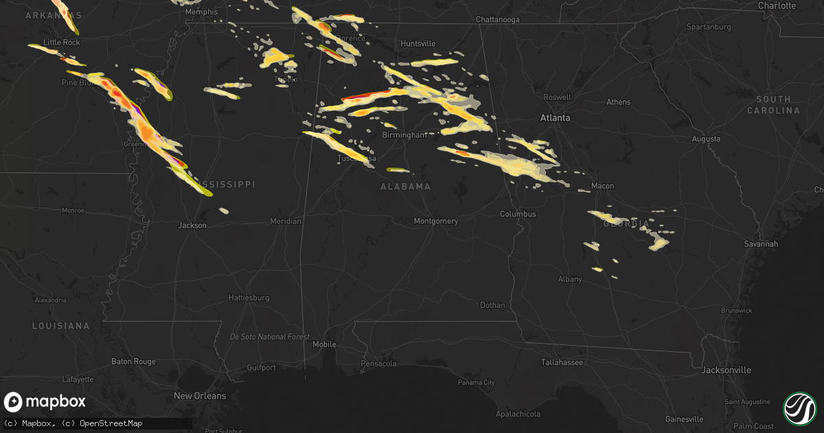
Hail Map in Alabama on March 31, 2015
Get this storm
March 31 map
$229
one time, instant access
Download today. No call, no setup
Keep the $229
Bought the map and want the full workflow? Apply the entire $229 to a subscription within 7 days. None of it is wasted.
Every map, not just this one
This buys you this map. Subscription and you get every map we run, in the markets you choose from a few cities to whole states to nationwide. Plus real-time alerts the moment a storm fires.
Contact data
Name, contact info, occupancy, even credit band for addresses in the footprint. You go from where it hit to who to call.
Become the source they trust
Unlimited branding weather history reports on demand. You already have the documented answer ready for the property owner, and you are the one who showed up with it.
Property data and RoofTrace estimates
Pull up any address you have got, its value and the exact code rules for that jurisdiction, straight from One Click Code. Then RoofTrace estimates the squares, pitch, and roof value, priced the way you price.
Storm reports in Alabama
Alabama
| Date | Description |
|---|---|
| 03/31/20156:52 PM CDT | Social media with photo |
| 03/31/20156:51 PM CDT | Via social media with photo |
| 03/31/20156:35 PM CDT | Dime to quarter size hail reported along highway 5 near jasper city limit |
| 03/31/20156:30 PM CDT | Quarter sized hail at mobbs school road and highway 431. |
| 03/31/20156:27 PM CDT | A local report indicates 1.00 inch wind near 8 SE WEST BLOCTON |
| 03/31/20156:26 PM CDT | Quarter sized hail reported in union grove. |
| 03/31/20156:18 PM CDT | Report via mping |
| 03/31/20156:13 PM CDT | Numerous reports of quarter to golf ball size hail in northport |
| 03/31/20156:13 PM CDT | Numerous reports of quarter to golfball size hail in tuscaloosa |
| 03/31/20156:05 PM CDT | A local report indicates 1.75 inch wind near COKER |
| 03/31/20156:05 PM CDT | A local report indicates 1.00 inch wind near 4 W HOLT |
| 03/31/20156:03 PM CDT | A local report indicates 1.00 inch wind near 1 W LAKE LURLEEN STATE |
| 03/31/20155:54 PM CDT | Quarter sized hail in brooklyn. |
| 03/31/20155:51 PM CDT | Via social media with photo. |
| 03/31/20155:50 PM CDT | Quarter sized hail in joppa. |
| 03/31/20155:41 PM CDT | Reported just to the east of reform via social media. |
| 03/31/20155:40 PM CDT | Along county 665 between al 22 and county 16 |
| 03/31/20155:36 PM CDT | Quarter sized hail on highway 75 near the blount county line. |
| 03/31/20155:36 PM CDT | Quarter sized hail on highway 75 near the blount county line. |
| 03/31/20155:30 PM CDT | Along highway 75 three miles south of marshall county line |
| 03/31/20155:23 PM CDT | Quarter sized hail possibly bigger covering the ground north of wadley |
| 03/31/20155:21 PM CDT | A local report indicates 1.75 inch wind near ALEXANDRIA |
| 03/31/20155:15 PM CDT | A local report indicates 1.75 inch wind near WEAVER |
| 03/31/20155:00 PM CDT | Golf ball sized hail in good hope. |
| 03/31/20155:00 PM CDT | A local report indicates 1.00 inch wind near 5 NNE ASHCRAFT CORNER |
| 03/31/20154:57 PM CDT | At least 2 inch hail via photo on social media. |
| 03/31/20154:55 PM CDT | Via photo on social media. |
| 03/31/20154:55 PM CDT | Near the intersection of hwy 77 and hwy 9 in ashland |
| 03/31/20154:55 PM CDT | Reported via social media |
| 03/31/20154:54 PM CDT | Via social media with photo. |
| 03/31/20154:46 PM CDT | Relayed twitter photo. Time estimated by radar. |
| 03/31/20154:45 PM CDT | Time corrected based on radar |
| 03/31/20154:42 PM CDT | A local report indicates 1.00 inch wind near OXFORD |
| 03/31/20154:41 PM CDT | A local report indicates 1.00 inch wind near WELLINGTON |
| 03/31/20154:41 PM CDT | Quarter to half dollar size hail reported north of ethelsville |
| 03/31/20154:39 PM CDT | At the intersection of doughboy rd and lister ferry rd via social media with photo. |
| 03/31/20154:37 PM CDT | Time corrected based on radar |
| 03/31/20154:36 PM CDT | Reported near coldwater |
| 03/31/20154:23 PM CDT | Also tree blown down on car |
| 03/31/20154:23 PM CDT | A local report indicates 1.00 inch wind near ARLEY |
| 03/31/20154:23 PM CDT | A local report indicates 1.00 inch wind near JACKSONVILLE |
| 03/31/20154:20 PM CDT | 1.5 to 2 inch hail measured at the hwy 411 crossing of canoe creek. |
| 03/31/20154:20 PM CDT | Approximately one mile south of the intersection of st clair cr24 and cr33. |
| 03/31/20154:15 PM CDT | Reported via social media along highway 411 |
| 03/31/20154:15 PM CDT | Golf ball sized hail reported in trimble. |
| 03/31/20154:10 PM CDT | Reported along mclain ave near blue eye trail. Time estimated from radar. |
| 03/31/20154:09 PM CDT | Along kent road one mile east of highway 75 near fridays crossing |
| 03/31/20154:05 PM CDT | A local report indicates 1.25 inch wind near 4 S LINCOLN |
| 03/31/20153:53 PM CDT | Via social media with photo. |
| 03/31/20153:51 PM CDT | A local report indicates 1.75 inch wind near 4 SSE LYNN |
| 03/31/20153:44 PM CDT | Relayed twitter photo. Time estimated by radar. |
| 03/31/20153:42 PM CDT | Relayed twitter photo. Time estimated by radar. |
| 03/31/20153:42 PM CDT | A local report indicates 1.00 inch wind near 3 N ELDRIDGE |
| 03/31/20153:33 PM CDT | Near exit 34 on i-22 |
| 03/31/20153:30 PM CDT | Quarter sized hail was reported. |
| 03/31/20153:30 PM CDT | Golf ball size hail was reported. |
| 03/31/20153:10 PM CDT | Reported via social media |
| 03/31/20153:00 PM CDT | A local report indicates 1.25 inch wind near 4 S BEAVERTON |
| 03/31/20153:00 PM CDT | A local report indicates 1.00 inch wind near 3 E SNEAD |
| 03/31/20152:52 PM CDT | Nickel to quarter size hail |
| 03/31/20152:28 PM CDT | Quarter to half dollar size hail...relayed by media. |
| 03/31/20152:13 PM CDT | Quarter sized hail covering the ground. |
| 03/31/20151:52 PM CDT | Time and location estimated by radar. Relayed twitter photos. |
| 03/31/20157:12 AM CDT | Quarter sized hail on nw side of waterloo. |
| 03/30/20159:03 PM CDT | Quarter size hail reported on interstate 59 between collinsville and fort payne about 3 miles south of fort payne |
| 03/30/20158:41 PM CDT | Quarter sized hail covering the ground in riverton. |
| 03/30/20158:08 PM CDT | Golf ball sized hail reported in waterloo. Relayed through twitter via broadcast media. |
| 03/30/20158:08 PM CDT | A local report indicates 1.00 inch wind near GRAYSVILLE |
| 03/30/20157:55 PM CDT | A local report indicates 1.00 inch wind near WEST JEFFERSON |
| 03/30/20157:23 PM CDT | Golf ball sized hail on main street. |
| 03/30/20157:12 PM CDT | Quarter sized hail on nw side of waterloo. |
All States Impacted by Hail Map on March 31, 2015
Cities Impacted by Hail Map on March 31, 2015
- Senoia, GA
- Sharpsburg, GA
- Florence, AL
- Killen, AL
- Wynnewood, OK
- Pauls Valley, OK
- Davis, OK
- Sulphur, OK
- Stratford, OK
- Roff, OK
- Oakman, AL
- Northport, AL
- Wadley, AL
- Daviston, AL
- Checotah, OK
- Eufaula, OK
- Iron City, TN
- Cypress Inn, TN
- Isola, MS
- Belzoni, MS
- Rochelle, GA
- Jefferson, AR
- Sherrill, AR
- White Hall, AR
- Butler, OK
- Clinton, OK
- Bellevue, TX
- Greenville, GA
- Lagrange, GA
- Marmaduke, AR
- Rector, AR
- Canadian, TX
- Russellville, AL
- Cherokee, AL
- Weatherford, TX
- Saint Joseph, TN
- Blue Springs, MS
- Ripley, MS
- Booneville, MS
- Baldwyn, MS
- Guntown, MS
- Dumas, MS
- New Albany, MS
- Blue Mountain, MS
- Greenbrier, AR
- Quitman, AR
- Damascus, AR
- Attalla, AL
- Holly Grove, AR
- Elaine, AR
- Clarksdale, MS
- Alligator, MS
- Duncan, MS
- Mellwood, AR
- Perry, OK
- Boley, OK
- Castle, OK
- Okemah, OK
- Anadarko, OK
- Gracemont, OK
- Porum, OK
- Nauvoo, AL
- Guntersville, AL
- Langston, AL
- Groveoak, AL
- Scottsboro, AL
- Section, AL
- Grant, AL
- New Hope, AL
- Bolivar, TN
- Whiteville, TN
- Selmer, TN
- Bernie, MO
- Hawkinsville, GA
- Kathleen, GA
- Cochran, GA
- Perry, GA
- Fort Valley, GA
- Erick, OK
- Jacksonville, AR
- Vilonia, AR
- Little Rock Air Force Base, AR
- Cabot, AR
- Moreland, GA
- Brooks, GA
- Gay, GA
- Carrollton, GA
- Newnan, GA
- Williamson, GA
- Earlsboro, OK
- Sasakwa, OK
- Tecumseh, OK
- Maud, OK
- Holdenville, OK
- Wewoka, OK
- Bowlegs, OK
- Seminole, OK
- Ashburn, GA
- Hogansville, GA
- Okarche, OK
- Kingfisher, OK
- Wabbaseka, AR
- Altheimer, AR
- Eads, TN
- Saltillo, MS
- Atoka, OK
- Blountsville, AL
- Hayden, AL
- Walters, OK
- Eldorado, OK
- Gould, OK
- Shiloh, TN
- Michie, TN
- Alamo, GA
- Glenwood, GA
- Gaylesville, AL
- Watson, AR
- Bethany, OK
- Oklahoma City, OK
- Centre, AL
- Gordo, AL
- England, AR
- Hensley, AR
- Redfield, AR
- Bee Branch, AR
- Banner, MS
- Winfield, AL
- Double Springs, AL
- Eldridge, AL
- Carbon Hill, AL
- Arley, AL
- Jasper, AL
- Lynn, AL
- Crane Hill, AL
- Townley, AL
- Millport, AL
- Ethelsville, AL
- Reform, AL
- Steens, MS
- Columbus, MS
- Woodbury, GA
- Meeker, OK
- Shawnee, OK
- Altoona, AL
- Oneonta, AL
- Union Grove, AL
- Fyffe, AL
- Somerville, AL
- Huntsville, AL
- Laceys Spring, AL
- Gillett, AR
- Tichnor, AR
- Stuttgart, AR
- Gould, AR
- Fayette, AL
- Fort Sill, OK
- Lawton, OK
- Elgin, OK
- Trumann, AR
- Harrisburg, AR
- Oakland, MS
- Warrior, AL
- Leedey, OK
- Hammon, OK
- Berry, AL
- Edmond, OK
- Alicia, AR
- Cache, OK
- Woodville, AL
- Childress, TX
- Mabelvale, AR
- Alexander, AR
- Bryant, AR
- Benton, AR
- Watonga, OK
- Yazoo City, MS
- Vaughan, MS
- Benton, MS
- Soperton, GA
- Hector, AR
- Witts Springs, AR
- Marshall, AR
- Tilly, AR
- Cullman, AL
- Hanceville, AL
- Fisk, MO
- Poplar Bluff, MO
- Broseley, MO
- Collinsville, AL
- Crossville, AL
- Boaz, AL
- Vinemont, AL
- Danville, AL
- Ryan, OK
- Caney, OK
- Lane, OK
- Guin, AL
- Beaverton, AL
- Sulligent, AL
- Ashland, AL
- Ridgely, TN
- Sweetwater, TX
- Cordova, AL
- Parrish, AL
- Newport, AR
- Amagon, AR
- Morton, MS
- Lena, MS
- Greenville, MS
- Indianola, MS
- Hollandale, MS
- Leland, MS
- Shannon, MS
- Tupelo, MS
- Holly Pond, AL
- Horton, AL
- Cleveland, AL
- Clinton, AR
- Loyal, OK
- Paden, OK
- Hayti, MO
- Geronimo, OK
- Echola, AL
- Buhl, AL
- Coker, AL
- Tuscaloosa, AL
- Cottondale, AL
- Elrod, AL
- Crumrod, AR
- Quanah, TX
- Heflin, AL
- Anniston, AL
- Oxford, AL
- Water Valley, MS
- Shidler, OK
- Mcloud, OK
- Forsyth, GA
- Benoit, MS
- Shaw, MS
- Rohwer, AR
- Mustang, OK
- Yukon, OK
- Wheatland, OK
- Halls, TN
- Earle, AR
- Crawfordsville, AR
- Hinton, OK
- Ashville, AL
- Rainbow City, AL
- Ohatchee, AL
- Gadsden, AL
- Calumet, OK
- Lineville, AL
- Montevallo, AL
- Brierfield, AL
- Piggott, AR
- Crescent, OK
- Marshall, OK
- Foss, OK
- Arapaho, OK
- Corn, OK
- Weatherford, OK
- Hydro, OK
- Lookeba, OK
- Custer City, OK
- Parma, MO
- Dexter, MO
- Bankston, AL
- Prague, OK
- Kaw City, OK
- Ponca City, OK
- McRae Helena, GA
- Weaver, AL
- Lincoln, AL
- Piedmont, AL
- Wellington, AL
- Steele, AL
- Talladega, AL
- Falkville, AL
- Alexandria, AL
- Jacksonville, AL
- Munford, AL
- Gallant, AL
- Brilliant, AL
- Pell City, AL
- Logan, AL
- Eastaboga, AL
- Hartselle, AL
- Bremen, AL
- Hennessey, OK
- Catron, MO
- Luthersville, GA
- Grantville, GA
- Copan, OK
- Scotland, AR
- Center Ridge, AR
- Weiner, AR
- Cash, AR
- Binger, OK
- El Reno, OK
- Minco, OK
- Union City, OK
- Stigler, OK
- Ailey, GA
- Mount Vernon, GA
- Enola, AR
- Tuscumbia, AL
- Luther, OK
- Ada, OK
- Peachtree City, GA
- Iowa Park, TX
- Albertville, AL
- Council Hill, OK
- Fort Cobb, OK
- Roanoke, AL
- Stanton, TN
- Somerville, TN
- Mason, TN
- Conway, AR
- Beulah, MS
- Humphrey, AR
- Dumas, AR
- Tchula, MS
- Moorhead, MS
- Silver City, MS
- Inverness, MS
- Itta Bena, MS
- De Witt, AR
- Tillar, AR
- Cleveland, MS
- Canton, MS
- Vienna, GA
- Empire, AL
- Sayre, OK
- Carter, OK
- Tutwiler, MS
- Clarendon, AR
- Lamar, MS
- Quinton, AL
- Dora, AL
- Franklin, GA
- Wedowee, AL
- Cragford, AL
- Stantonville, TN
- Lexington, OK
- Macomb, OK
- Wanette, OK
- Noble, OK
- Indiahoma, OK
- Graysville, AL
- Adamsville, AL
- Guys, TN
- Ramer, TN
- Hollister, OK
- Frederick, OK
- Bartlesville, OK
- Asher, OK
- Belden, MS
- Harrah, OK
- Rose Bud, AR
- Mount Vernon, AR
- Brookwood, AL
- Lindsay, OK
- Counce, TN
- Leighton, AL
- Iuka, MS
- Corinth, MS
- Sheffield, AL
- Savannah, TN
- Waterloo, AL
- Town Creek, AL
- Cordele, GA
- Crowell, TX
- Coffeeville, MS
- Chillicothe, TX
- Chandler, OK
- Hitchcock, OK
- Okeene, OK
- Lutts, TN
- Westpoint, TN
- Loretto, TN
- Tishomingo, MS
- Burnsville, MS
- Vernon, TX
- Thomaston, GA
- Yatesville, GA
- Lexington, AL
- Potts Camp, MS
- Hickory Flat, MS
- Hollis, OK
- Calera, AL
- Osceola, AR
- Henning, TN
- Ripley, TN
- Covington, TN
- Higgins, TX
- Musella, GA
- Knoxville, GA
- Lizella, GA
- Enid, MS
- Gepp, AR
- Five Points, AL
- Calico Rock, AR
- Choctaw, OK
- Jones, OK
- Allen, OK
- Red Bay, AL
- Vina, AL
- Tucker, AR
- Little Rock, AR
- Saint Charles, AR
- Meridian, OK
- Guthrie, OK
- Warm Springs, GA
- Manchester, GA
- Shiloh, GA
- Arab, AL
- Finley, TN
- Morris, OK
- Boynton, OK
- Barnesville, GA
- Dutton, AL
- Rainsville, AL
- Cherry Valley, AR
- Horseshoe Bend, AR
- Evening Shade, AR
- Sidney, AR
- Newalla, OK
- Norman, OK
- Parkin, AR
- Fisher, AR
- Apache, OK
- Adrian, GA
- Rockledge, GA
- East Dublin, GA
- Konawa, OK
- Alpine, AL
- Molena, GA
- Byhalia, MS
- Holly Springs, MS
- Rossville, TN
- Collierville, TN
- Haleyville, AL
- Bear Creek, AL
- Leesburg, AL
- Myrtle, MS
- Tupelo, OK
- Fort Payne, AL
- Sage, AR
- Melbourne, AR
- Franklin, AR
- Coalgate, OK
- Arcadia, OK
- Poughkeepsie, AR
- Swifton, AR
- Bowdon, GA
- Dexter, GA
- Chester, GA
- Oakland, TN
- Concord, GA
- Roopville, GA
- Whitesburg, GA
- Leslie, AR
- Cleveland, AR
- Red Banks, MS
- Paron, AR
- Dublin, GA
- Cadwell, GA
- Rentz, GA
- Ragland, AL
- Vernon, AL
- Ranburne, AL
- Eva, AL
- Moulton, AL
- Houston, AL
- Baileyton, AL
- Paducah, TX
- Almyra, AR
- Mooreville, MS
- Lexington, MS
- Wann, OK
- Coffeyville, KS
- Dawson, AL
- Elk City, OK
- Duncan, OK
- Goodwater, AL
- Millerville, AL
- Oxford, MS
- Orlando, OK
- West Point, GA
- Delta, AL
- Marston, MO
- Pickens, MS
- Caddo, OK
- Jemison, AL
- Marland, OK
- Salem, AR
- Cheyenne, OK
- Caledonia, MS
- Hamilton, MS
- Fitzhugh, OK
- Lafe, AR
- Davidson, OK
- Woodland, GA
- Kennedy, AL
- Zebulon, GA
- Fayetteville, GA
- Riverside, AL
- Stonewall, OK
- Paris, MS
- Holcomb, MO
- Kennett, MO
- Pine Mountain, GA
- Rush Springs, OK
- Griffin, GA
- Eutaw, AL
- Phil Campbell, AL
- Wellston, OK
- Dry Branch, GA
- Loveland, OK
- Swainsboro, GA
- Spencer, OK
- Memphis, TN
- Pope, MS
- Courtland, MS
- Anderson, AL
- Marlow, OK
- Cedar Bluff, AL
- Mantachie, MS
- Falkner, MS
- Ashland, MS
- Greenway, AR
- Bruce, MS
- Carnegie, OK
- Smithville, AR
- Centrahoma, OK
- Chickasha, OK
- Pocasset, OK
- Verden, OK
- Chula, GA
- Red Oak, OK
- Marion, AR
- Millington, TN
- Marked Tree, AR
- Muscadine, AL
- Tallapoosa, GA
- Duke, OK
- Canute, OK
- Henryetta, OK
- Fletcher, OK
- Talihina, OK
- Lumber City, GA
- Uvalda, GA
- Toone, TN
- Hornsby, TN
- Faxon, OK
- Coleman, OK
- Eastman, GA
- Quinton, OK
- Fruithurst, AL
- Hickory Valley, TN
- Doniphan, MO
- Woodland, AL
- Meansville, GA
- Cropwell, AL
- Glen, MS
- Tyrone, GA
- Sparks, OK
- Rosedale, MS
- Camden, MS
- Guy, AR
- Drew, MS
- Bethel Springs, TN


