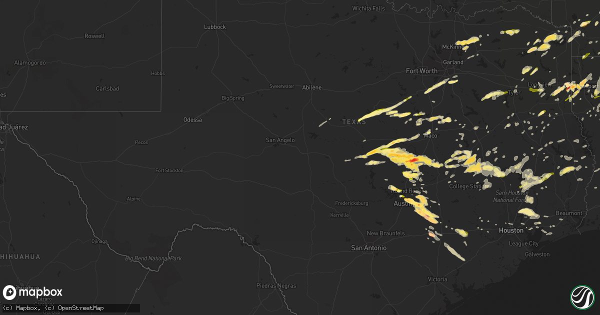
Hail Map in Texas on March 28, 2014
Get this storm
March 28 map
$229
one time, instant access
Download today. No call, no setup
Keep the $229
Bought the map and want the full workflow? Apply the entire $229 to a subscription within 7 days. None of it is wasted.
Every map, not just this one
This buys you this map. Subscription and you get every map we run, in the markets you choose from a few cities to whole states to nationwide. Plus real-time alerts the moment a storm fires.
Contact data
Name, contact info, occupancy, even credit band for addresses in the footprint. You go from where it hit to who to call.
Become the source they trust
Unlimited branding weather history reports on demand. You already have the documented answer ready for the property owner, and you are the one who showed up with it.
Property data and RoofTrace estimates
Pull up any address you have got, its value and the exact code rules for that jurisdiction, straight from One Click Code. Then RoofTrace estimates the squares, pitch, and roof value, priced the way you price.
Storm reports in Texas
Texas
| Date | Description |
|---|---|
| 03/28/20146:57 PM CDT | A local report indicates 1.00 inch wind near LIVINGSTON |
| 03/28/20146:50 PM CDT | A local report indicates 1.00 inch wind near 4 SE FLATONIA |
| 03/28/20146:50 PM CDT | Numerous trees and power lines down across the county. |
| 03/28/20146:47 PM CDT | A local report indicates 1.00 inch wind near LONGVIEW |
| 03/28/20146:45 PM CDT | Numerous trees down |
| 03/28/20146:40 PM CDT | Numerous trees down...power lines down county wide |
| 03/28/20146:40 PM CDT | A local report indicates 1.00 inch wind near FLATONIA |
| 03/28/20146:25 PM CDT | Numerous trees and power lines down across the county |
| 03/28/20146:18 PM CDT | A local report indicates 1.00 inch wind near RUSK |
| 03/28/20146:15 PM CDT | A local report indicates 1.00 inch wind near MOUNT PLEASANT |
| 03/28/20146:15 PM CDT | Numerous trees down...power lines down |
| 03/28/20146:09 PM CDT | Most hailstones ranged from one half to three quarters of an inch |
| 03/28/20146:09 PM CDT | A local report indicates 1.25 inch wind near 4 SE SMITHVILLE |
| 03/28/20146:00 PM CDT | Baseballl size hail was reported in waskom tx. |
| 03/28/20146:00 PM CDT | A local report indicates 1.00 inch wind near 5 NE MOUNT PLEASANT |
| 03/28/20146:00 PM CDT | Most hailstones ranged from one half to three quarters of an inch. It hailed for 15 minutes. |
| 03/28/20145:57 PM CDT | Tree snapped and fence blown over |
| 03/28/20145:55 PM CDT | A local report indicates 1.00 inch wind near 4 ENE MADISONVILLE |
| 03/28/20145:51 PM CDT | Trees down |
| 03/28/20145:50 PM CDT | 1 inch hail and several trees down in wamba |
| 03/28/20145:50 PM CDT | 1 inch hail ans several trees down in wamba |
| 03/28/20145:49 PM CDT | Near intersection of fm31 and fm2625 |
| 03/28/20145:49 PM CDT | A local report indicates 1.00 inch wind near 4 ENE MADISONVILLE |
| 03/28/20145:45 PM CDT | A local report indicates 1.25 inch wind near MARSHALL |
| 03/28/20145:35 PM CDT | Power lines downed and possible roof damage |
| 03/28/20145:35 PM CDT | Large pine trees downed/damaged |
| 03/28/20145:35 PM CDT | A local report indicates 65 MPH wind near CENTERVILLE |
| 03/28/20145:35 PM CDT | A local report indicates 1.75 inch wind near 4 W BASTROP |
| 03/28/20145:33 PM CDT | A local report indicates 1.75 inch wind near 4 W BASTROP |
| 03/28/20145:30 PM CDT | A local report indicates 1.00 inch wind near BOGATA |
| 03/28/20145:30 PM CDT | One side of a building damaged in centerville due to strong winds. |
| 03/28/20145:30 PM CDT | A local report indicates 1.00 inch wind near 2 W BASTROP |
| 03/28/20145:28 PM CDT | A local report indicates 1.00 inch wind near 1 S DEPORT |
| 03/28/20145:27 PM CDT | Hilltop lakes |
| 03/28/20145:25 PM CDT | A local report indicates 1.00 inch wind near 3 NNW BASTROP |
| 03/28/20145:25 PM CDT | A local report indicates 1.75 inch wind near 12 W MADISONVILLE |
| 03/28/20145:24 PM CDT | A local report indicates 1.00 inch wind near 4 SW DEPORT |
| 03/28/20145:15 PM CDT | A local report indicates 1.75 inch wind near 7 SSW ELGIN |
| 03/28/20145:15 PM CDT | A local report indicates 1.00 inch wind near MARQUEZ |
| 03/28/20145:14 PM CDT | Hilltop lakes |
| 03/28/20145:06 PM CDT | A local report indicates 1.00 inch wind near EASTERLY |
| 03/28/20145:03 PM CDT | Elgin high school |
| 03/28/20145:01 PM CDT | A local report indicates 1.00 inch wind near CALVERT |
| 03/28/20144:52 PM CDT | A local report indicates 1.00 inch wind near 5 ENE AUSTIN |
| 03/28/20144:52 PM CDT | A local report indicates 1.00 inch wind near AUSTIN BERGSTROM INT AP |
| 03/28/20144:48 PM CDT | 2 trees down accross highway |
| 03/28/20144:48 PM CDT | Trees down |
| 03/28/20144:45 PM CDT | A local report indicates 1.00 inch wind near DAINGERFIELD |
| 03/28/20144:45 PM CDT | A local report indicates 1.75 inch wind near 2 W MANOR |
| 03/28/20144:45 PM CDT | A local report indicates 1.00 inch wind near 3 N ATHENS |
| 03/28/20144:45 PM CDT | A local report indicates 1.00 inch wind near 5 ENE AUSTIN |
| 03/28/20144:45 PM CDT | A local report indicates 1.00 inch wind near 7 NE AUSTIN |
| 03/28/20144:44 PM CDT | A local report indicates 1.75 inch wind near 5 NE AUSTIN |
| 03/28/20144:42 PM CDT | A local report indicates 1.75 inch wind near 4 NE AUSTIN |
| 03/28/20144:39 PM CDT | A local report indicates 1.25 inch wind near FERRIS |
| 03/28/20144:38 PM CDT | Nickel to quarter size hail |
| 03/28/20144:35 PM CDT | A local report indicates 1.00 inch wind near FERRIS |
| 03/28/20144:35 PM CDT | Hail stones ranging from pea size to one inch occurring on and off for more than five minutes |
| 03/28/20144:35 PM CDT | 1 inch hail at spicewood springs and mopac |
| 03/28/20144:34 PM CDT | Hail damaged vehicles from golfball size hail |
| 03/28/20144:33 PM CDT | A local report indicates 1.00 inch wind near 6 N AUSTIN |
| 03/28/20144:30 PM CDT | A local report indicates 1.00 inch wind near 4 N AUSTIN |
| 03/28/20144:30 PM CDT | A local report indicates 1.75 inch wind near JOLLYVILLE |
| 03/28/20144:30 PM CDT | A local report indicates 1.00 inch wind near 4 SSW WELLS BRANCH |
| 03/28/20144:22 PM CDT | A local report indicates 1.50 inch wind near CEDAR PARK |
| 03/28/20144:21 PM CDT | A local report indicates 1.75 inch wind near 1 NE CEDAR PARK |
| 03/28/20144:20 PM CDT | Hail covering the ground |
| 03/28/20144:18 PM CDT | Storm spotter reported 1 inch hail near fm569 and fm990 near simms tx. |
| 03/28/20144:15 PM CDT | A local report indicates 1.00 inch wind near BEN ARNOLD |
| 03/28/20144:15 PM CDT | Windows blown out of one side of a house |
| 03/28/20144:15 PM CDT | A local report indicates 1.25 inch wind near 5 SW ANDERSON MILL |
| 03/28/20144:10 PM CDT | A local report indicates 1.00 inch wind near RED OAK |
| 03/28/20144:05 PM CDT | A local report indicates 1.00 inch wind near WEIR |
| 03/28/20143:52 PM CDT | A local report indicates 1.00 inch wind near BAILEY |
| 03/28/20143:52 PM CDT | A local report indicates 1.00 inch wind near MIDLOTHIAN |
| 03/28/20143:50 PM CDT | A local report indicates 1.00 inch wind near CELESTE |
| 03/28/20143:49 PM CDT | A local report indicates 1.75 inch wind near 1 E JARRELL |
| 03/28/20143:45 PM CDT | *delayed report* hail damage to vehicles was reported along highway 190 in town. |
| 03/28/20143:44 PM CDT | Multiple houses in the dawson ranch subdivision had windows broken due to wind driven hail |
| 03/28/20143:42 PM CDT | At scott white hospital |
| 03/28/20143:42 PM CDT | At scott white hospital |
| 03/28/20143:41 PM CDT | A local report indicates 1.50 inch wind near BLUE RIDGE |
| 03/28/20143:35 PM CDT | A local report indicates 1.25 inch wind near 4 W JARRELL |
| 03/28/20143:35 PM CDT | A local report indicates 1.50 inch wind near SALADO |
| 03/28/20143:33 PM CDT | A local report indicates 1.00 inch wind near BLUE RIDGE |
| 03/28/20143:28 PM CDT | A local report indicates 1.75 inch wind near TEMPLE |
| 03/28/20143:26 PM CDT | Hwy 190 and 1570 |
| 03/28/20143:20 PM CDT | Intersection of hwys 36 and 360 |
| 03/28/20143:07 PM CDT | Khlr reported 58 knots |
| 03/28/20143:06 PM CDT | A local report indicates 1.50 inch wind near FORT HOOD |
| 03/28/20143:02 PM CDT | N side of 190 near fort hood |
| 03/28/20143:02 PM CDT | A local report indicates 1.50 inch wind near 1 SSE MERIDIAN |
| 03/28/20142:58 PM CDT | A local report indicates 1.50 inch wind near MERIDIAN |
| 03/28/20142:42 PM CDT | A local report indicates 1.75 inch wind near COPPERAS COVE |
| 03/28/20142:40 PM CDT | A local report indicates 1.50 inch wind near COPPERAS COVE |
| 03/28/20142:35 PM CDT | A local report indicates 1.00 inch wind near 17 NE TOW |
| 03/28/20142:34 PM CDT | A local report indicates 1.00 inch wind near LAMPASAS |
| 03/28/20142:23 PM CDT | A local report indicates 1.50 inch wind near 7 W GATESVILLE |
| 03/28/20141:58 PM CDT | A local report indicates 1.00 inch wind near 2 S HICO |
| 03/28/20141:21 PM CDT | Golf ball sized hail in lometa |
| 03/27/20148:27 PM CDT | Public estimates wind gust of 60-70 mph and small hail |
| 03/27/20148:26 PM CDT | Public reports hail varying in size between a quarter and half dollar size at the sonic in downtown jasper |
| 03/27/20148:23 PM CDT | Newton county sheriff reports trees down in burkeville and a car blown off the road. Time estimated by radar |
| 03/27/20148:20 PM CDT | Jasper county sheriff reports trees down along fm 1004 in kirbyville. |
| 03/27/20148:20 PM CDT | Jasper county sheriff reports trees down along fm 1013 in magnolia springs. |
| 03/27/20148:02 PM CDT | Public reports hail varying in size between a quarter and half dollar size at the sonic in downtown jasper |
| 03/27/20148:00 PM CDT | Widespread trees and powerlines down throughout the county |
| 03/27/20147:49 PM CDT | Two trees down at rv park. Wind estimated at 60 mph. |
| 03/27/20147:45 PM CDT | Widespread trees and powerlines down...mainly across the southern half of the county |
| 03/27/20147:45 PM CDT | Widespread trees down throughout the county |
| 03/27/20147:45 PM CDT | Tyler county sheriff reports numerous trees and powerlines down in woodville |
| 03/27/20147:42 PM CDT | A local report indicates 1.00 inch wind near 9 NE SPEAKS |
| 03/27/20147:36 PM CDT | Numerous trees down including one that fell on a vehicle along spring valley rd. Power has also been knocked out to the area hospital. |
| 03/27/20147:00 PM CDT | Widespread trees down throughout the county. Several trees on automobiles. |
| 03/27/20147:00 PM CDT | Widespread trees down throughout the county |
| 03/27/20147:00 PM CDT | Trees down on various roads throughout walker county... Especially the northern part of the county. |
All States Impacted by Hail Map on March 28, 2014
Cities Impacted by Hail Map on March 28, 2014
- Hollandale, MS
- Paron, AR
- Leland, MS
- Eudora, AR
- Greenville, MS
- Lake Village, AR
- Shreveport, LA
- Texarkana, AR
- Leesville, LA
- Blue Ridge, TX
- Leonard, TX
- Celeste, TX
- Farmersville, TX
- Wolfe City, TX
- Silver City, MS
- Tchula, MS
- Meridian, TX
- Anderson, TX
- Jarrell, TX
- Bartlett, TX
- Georgetown, TX
- Mansfield, LA
- Pelican, LA
- Bearden, AR
- Hampton, AR
- Thornton, AR
- Farmerville, LA
- Marion, LA
- Emerson, AR
- Bastrop, TX
- Cedar Creek, TX
- Big Sandy, TX
- Austin, TX
- Sterlington, LA
- Burlington, TX
- Rosebud, TX
- Cameron, TX
- Gatesville, TX
- Lampasas, TX
- Livingston, TX
- Waskom, TX
- Gilmer, TX
- Ferris, TX
- Lancaster, TX
- Red Oak, TX
- Bossier City, LA
- Midway, TX
- Huntsville, TX
- Temple, TX
- Little River Academy, TX
- Gibsland, LA
- Mount Pleasant, TX
- Omaha, TX
- Copperas Cove, TX
- Cleveland, TX
- Dayton, TX
- Camden, AR
- Valley Mills, TX
- Whitney, TX
- Clifton, TX
- Aquilla, TX
- Warren, AR
- Oktaha, OK
- Satsuma, AL
- Eight Mile, AL
- Saraland, AL
- Hope, AR
- Fulton, AR
- Rayville, LA
- Thrall, TX
- Dundee, MS
- Helena, AR
- Iredell, TX
- Richards, TX
- Bedias, TX
- Union Church, MS
- Trinity, TX
- Talco, TX
- McDade, TX
- Elgin, TX
- Naples, TX
- Marietta, TX
- Emmet, AR
- Sparkman, AR
- Kingsland, AR
- Fordyce, AR
- Ivan, AR
- Crossett, AR
- Hermitage, AR
- Marshall, TX
- Dublin, TX
- Arkadelphia, AR
- Gurdon, AR
- Magnolia, AR
- Kempner, TX
- Sealy, TX
- Maud, TX
- Canton, MS
- Madison, MS
- Huffman, TX
- New Caney, TX
- Porter, TX
- Portland, AR
- Montrose, AR
- Hamburg, AR
- Gilbert, LA
- Sicily Island, LA
- Texarkana, TX
- Jefferson, TX
- Jasper, TX
- Newton, TX
- Wiergate, TX
- Louise, MS
- Yazoo City, MS
- Simms, TX
- De Kalb, TX
- New Boston, TX
- Normangee, TX
- Penelope, TX
- Mount Calm, TX
- Douglass, TX
- Nacogdoches, TX
- Monticello, AR
- Oakwood, TX
- Bethany, LA
- Jewett, TX
- Rolling Fork, MS
- Valley Park, MS
- Mayersville, MS
- Jamestown, LA
- Castor, LA
- Huttig, AR
- Pineville, LA
- Deville, LA
- Coupland, TX
- Flatonia, TX
- Schulenburg, TX
- San Saba, TX
- Nevada, TX
- Killeen, TX
- Bogata, TX
- Deport, TX
- Pattonville, TX
- Paris, TX
- Greenwood, LA
- Dubberly, LA
- Caldwell, TX
- Louise, TX
- Strong, AR
- El Dorado, AR
- Durant, MS
- Salado, TX
- Lometa, TX
- Harker Heights, TX
- Florence, TX
- Crawford, TX
- Belton, TX
- Oglesby, TX
- Granger, TX
- Nolanville, TX
- Evant, TX
- Holland, TX
- Bend, TX
- Lott, TX
- Troy, TX
- Rogers, TX
- Fort Hood, TX
- McGregor, TX
- Hearne, TX
- Gause, TX
- Carlton, TX
- Gustine, TX
- Glen Rose, TX
- Hico, TX
- Blanket, TX
- Nemo, TX
- Walnut Springs, TX
- Comanche, TX
- Oak Grove, LA
- Muldoon, TX
- Sallis, MS
- Faunsdale, AL
- Uniontown, AL
- Marquez, TX
- Franklin, TX
- Mexia, TX
- Wortham, TX
- Smithville, TX
- Coolidge, TX
- Hubbard, TX
- Dawson, TX
- Lufkin, TX
- Midlothian, TX
- Waxahachie, TX
- North Zulch, TX
- Bryan, TX
- Madisonville, TX
- Princeton, TX
- Burkeville, TX
- Deridder, LA
- Mount Enterprise, TX
- Long Branch, TX
- Coushatta, LA
- Lexa, AR
- Vidalia, LA
- Marksville, LA
- Cleburne, TX
- Anguilla, MS
- Vicksburg, MS
- Sondheimer, LA
- Ringgold, LA
- Pickens, MS
- Benton, MS
- Lexington, MS
- Kosciusko, MS
- Carthage, MS
- Centerville, TX
- Leona, TX
- Palestine, TX
- Hooks, TX
- Abbott, TX
- Baytown, TX
- Belzoni, MS
- Isola, MS
- Annona, TX
- Avery, TX
- Georgetown, LA
- Barksdale Afb, LA
- Jena, LA
- Vian, OK
- Winnfield, LA
- Atlanta, LA
- Dry Prong, LA
- Wallisville, TX
- Liberty, TX
- Manor, TX
- La Grange, TX
- Giddings, TX
- Wilmar, AR
- Banks, AR
- Minden, LA
- Sibley, LA
- Doyline, LA
- West Point, TX
- Eufaula, OK
- Colmesneil, TX
- Washington, AR
- Ozan, AR
- Prescott, AR
- Leander, TX
- Council Hill, OK
- Columbia, LA
- West Helena, AR
- Sledge, MS
- Woodville, TX
- Lincoln, TX
- Paige, TX
- Lexington, TX
- Lafayette, LA
- Moscow, TX
- Athens, TX
- Eustace, TX
- Henryetta, OK
- Okmulgee, OK
- Daingerfield, TX
- Hughes Springs, TX
- Spearsville, LA
- Lovelady, TX
- Cookville, TX
- Huntington, TX
- Garrison, TX
- Timpson, TX
- Jones, LA
- Venus, TX
- Alvarado, TX
- Grandview, TX
- Desoto, TX
- Transylvania, LA
- Lake Providence, LA
- Carthage, TX
- Malvern, AR
- Traskwood, AR
- Winnie, TX
- Glen Allan, MS
- Mooringsport, LA
- Singer, LA
- Carthage, AR
- Rison, AR
- Pittsburg, TX
- Coldspring, TX
- Brewton, AL
- West, TX
- Crockett, TX
- Wilmot, AR
- Plain Dealing, LA
- Morganza, LA
- Gonzales, LA
- Prairieville, LA
- Chireno, TX
- Plaquemine, LA
- Saint Gabriel, LA
- White Castle, LA
- Carville, LA
- Murchison, TX
- Tallulah, LA
- Frisco City, AL
- Cedar Park, TX
- Keithville, LA
- Anahuac, TX
- Sheridan, AR
- Benton, AR
- Mangham, LA
- Oak Ridge, LA
- Brownsboro, TX
- Ben Wheeler, TX
- Hemphill, TX
- Charleston, MS
- Goodrich, TX
- Bastrop, LA
- Dermott, AR
- Jersey, AR
- Parkdale, AR
- Chatham, MS
- Fountain Hill, AR
- Bonita, LA
- Mer Rouge, LA
- Pioneer, LA
- Indianola, MS
- McCool, MS
- Rusk, TX
- Camden, MS
- Rohwer, AR
- Newellton, LA
- Crenshaw, MS
- Sardis, MS
- Coahoma, MS
- Ore City, TX
- Groveton, TX
- Eagle Lake, TX
- Calvert, TX
- Bremond, TX
- Cat Spring, TX
- Alleyton, TX
- Columbus, TX
- Alto, TX
- Seminole, OK
- Marks, MS
- Poplar Grove, AR
- Linden, TX
- Karnack, TX
- Fairfield, TX
- Stonewall, LA
- Gloster, LA
- Hallettsville, TX
- De Berry, TX
- Keatchie, LA
- Morgan, TX
- Taylor, TX
- Hutto, TX
- Clarendon, AR
- Casscoe, AR
- Longview, TX
- Cranfills Gap, TX
- Breaux Bridge, LA
- Mount Holly, AR
- Converse, LA
- Holly Grove, AR
- Marvell, AR
- Simmesport, LA
- Moreauville, LA
- Valera, TX
- Coleman, TX
- Sublime, TX
- El Campo, TX
- Garwood, TX
- Saline, LA
- Mckinney, TX
- Anna, TX
- Melissa, TX
- Stephens, AR
- Lewisville, AR
- Theodore, AL
- Mobile, AL
- Kilgore, TX
- Monterey, LA
- Jonesville, LA
- Aubrey, AR
- Apple Springs, TX
- Pollock, LA
- Natchez, MS
- Jacksonville, TX
- Houston, TX
- Dubach, LA
- Lettsworth, LA
- Plaucheville, LA
- Groesbeck, TX
- Kelly, LA
- Grayson, LA
- Olla, LA
- Moulton, TX
- Daphne, AL
- Bay Minette, AL
- Itasca, TX
- Milford, TX
- Hineston, LA
- Fort Polk, LA
- Pitkin, LA
- Batesville, MS
- Greenville, TX
- Commerce, TX
- Saint Landry, LA
- Beaumont, TX
- Danville, AR
- Ashdown, AR
- Creola, AL
- Semmes, AL
- Laneville, TX
- Kosse, TX
- Malone, TX
- Milam, TX
- San Augustine, TX
- Bronson, TX
- Devers, TX
- Bertram, TX
- Heflin, LA
- Winnsboro, LA
- Seagoville, TX
- Campti, LA
- Hot Springs National Park, AR
- Kirbyville, TX
- Weleetka, OK
- Lake Creek, TX
- Cooper, TX
- Brookshire, TX
- Waller, TX
- Beckville, TX
- Tatum, TX
- Pleasant Hill, LA
- Marthaville, LA
- Robeline, LA
- Bienville, LA
- Merigold, MS
- Franklin, LA
- Tyler, TX
- Harrell, AR
- Summerfield, LA
- Haynesville, LA
- Bernice, LA
- Hockley, TX
- Katy, TX
- Center Point, LA
- Milton, FL
- Jay, FL
- Royse City, TX
- Caddo Mills, TX
- Brookeland, TX
- Broaddus, TX
- Lillie, LA
- Junction City, AR
- Sikes, LA
- Dodson, LA
- Stockton, AL
- Hallsville, TX
- Vaughan, MS
- Chatham, LA
- Corrigan, TX
- Chunchula, AL
- Rosedale, MS
- Waco, TX
- Hot Springs Village, AR
- New Edinburg, AR
- Zavalla, TX
- Goldthwaite, TX
- Weimar, TX
- Elm Grove, LA
- Hempstead, TX
- Wilmer, TX
- Princeton, LA
- Haughton, LA
- Harrisonburg, LA
- Roe, AR
- Highlands, TX
- Crosby, TX
- Denham Springs, LA
- Baton Rouge, LA
- Henderson, TX
- Enterprise, LA
- Taylor, AR
- Shepherd, TX
- Thornton, TX
- Chandler, TX
- Frankston, TX
- Rosepine, LA
- Kingwood, TX
- Tullos, LA
- Buffalo, TX
- Ruleville, MS
- Homer, LA
- Cottonport, LA
- Mansura, LA
- West Monroe, LA
- Merryville, LA
- Evans, LA
- Wisner, LA
- Effie, LA
- Watson, AR
- Gunnison, MS
- Jonesboro, LA
- Iola, TX
- Axtell, TX
- Cushing, TX
- Liberty, MS
- Muskogee, OK
- Mamou, LA
- Eunice, LA
- Pecan Gap, TX
- Ladonia, TX
- Springhill, LA
- Marble Falls, TX
- Onalaska, TX
- Atmore, AL
- Jeanerette, LA
- Dequincy, LA
- Buckner, AR
- Stamps, AR
- Warren, TX
- Waelder, TX
- Malakoff, TX
- Colfax, LA
- Alexandria, LA
- Boyce, LA
- Oakdale, LA
- Fayetteville, AR
- Acme, LA
- Patterson, LA
- Baskin, LA
- Dauphin Island, AL
- Church Point, LA
- Monroeville, AL
- Walker, LA
- Benton, LA
- Woodway, TX
- Monroe, LA
- Delhi, LA
- Lorman, MS
- Pattison, MS
- Slidell, LA
- Fulshear, TX
- Bradley, AR
- Morris, OK
- Boynton, OK
- Purmela, TX


