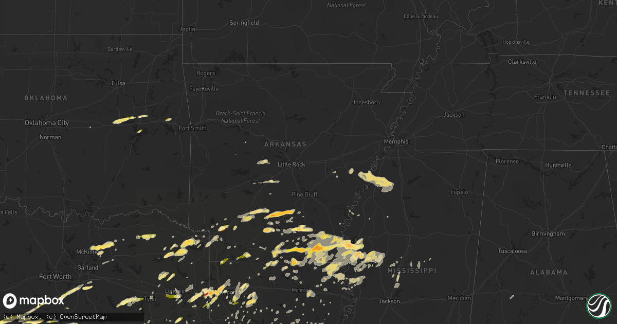
Hail Map in Arkansas on March 28, 2014
Get this storm
March 28 map
$229
one time, instant access
Download today. No call, no setup
Keep the $229
Bought the map and want the full workflow? Apply the entire $229 to a subscription within 7 days. None of it is wasted.
Every map, not just this one
This buys you this map. Subscription and you get every map we run, in the markets you choose from a few cities to whole states to nationwide. Plus real-time alerts the moment a storm fires.
Contact data
Name, contact info, occupancy, even credit band for addresses in the footprint. You go from where it hit to who to call.
Become the source they trust
Unlimited branding weather history reports on demand. You already have the documented answer ready for the property owner, and you are the one who showed up with it.
Property data and RoofTrace estimates
Pull up any address you have got, its value and the exact code rules for that jurisdiction, straight from One Click Code. Then RoofTrace estimates the squares, pitch, and roof value, priced the way you price.
Storm reports in Arkansas
Arkansas
| Date | Description |
|---|---|
| 03/28/20146:48 PM CDT | A tree fell into a house. |
| 03/28/20146:40 PM CDT | A local report indicates 1.75 inch wind near CAMDEN |
| 03/28/20146:39 PM CDT | A local report indicates 1.00 inch wind near 1 S MONTROSE |
| 03/28/20146:32 PM CDT | Occurred on macon lake rd |
| 03/28/20146:30 PM CDT | Numerous trees down |
| 03/28/20146:30 PM CDT | Trees down on highway 79 |
| 03/28/20146:30 PM CDT | About 10 power poles snapped at the base. Report via social media. Possible tornado |
| 03/28/20146:27 PM CDT | Quarter sized hail reported. |
| 03/28/20146:15 PM CDT | Report from social media |
| 03/28/20146:05 PM CDT | A local report indicates 1.75 inch wind near 1 N HAMBURG |
| 03/28/20146:02 PM CDT | A local report indicates 1.75 inch wind near HAMBURG |
| 03/28/20145:45 PM CDT | A local report indicates 1.00 inch wind near HOPE |
| 03/28/20145:40 PM CDT | Penny to quarter size hail was increasing in volume between collins and cominto along arkansas 35. |
| 03/28/20145:07 PM CDT | Quarter to golf ball sized hail covered the ground along ashley road 298. |
| 03/28/20144:59 PM CDT | Trees down...power lines down |
| 03/28/20144:41 PM CDT | Quarter size hail fell at green hill...which is 4 to 5 miles southwest of monticello... |
| 03/28/20144:17 PM CDT | Hail from quarter to half dollar size was beginning to cover the parking lot at the state police troop headquarters on the south side of warren. |
| 03/28/20144:13 PM CDT | A local report indicates 1.75 inch wind near WARREN |
| 03/28/20144:00 PM CDT | A local report indicates 1.00 inch wind near 7 W WARREN |
| 03/28/20143:50 PM CDT | Hail up to golf ball size hail fell...breaking windows in cars. |
| 03/28/20143:50 PM CDT | A local report indicates 1.00 inch wind near RISON |
| 03/28/20143:33 PM CDT | Hail from marble to golf ball size fell on u.s. 167 north of fordyce...near ivan. |
| 03/28/20143:33 PM CDT | Hail measured 2 1/4 inches in diameter between fordyce and ivan. Windshields were broken. |
| 03/28/20143:04 PM CDT | A local report indicates 1.75 inch wind near HOLLY SPRINGS |
| 03/28/20142:40 PM CDT | A local report indicates 1.00 inch wind near SPARKMAN |
| 03/27/20149:17 PM CDT | Straight line wind damage began near highway 65 just south of eudora where five power poles were snapped. Also damage was along grand lake loop where a large tree was s |
| 03/27/20149:17 PM CDT | Straight line wind damage began near highway 65 just south of eudora where five power poles were snapped. Also damage was along grand lake loop where a large tree was s |
| 03/27/20149:00 PM CDT | Dime to quarter size hail. Reported via social media. |
| 03/27/20148:59 PM CDT | Swath of straight line wind damage began near highway 165 between portland and parkdale. Eight wooden power poles were snapped off to the east along highway 165 south o |
| 03/27/20148:15 PM CDT | Reports of nickel to quarter size hail on king circle. Also a few tree limbs were blown down. |
| 03/27/20147:55 PM CDT | Several trees and power lines down |
| 03/27/20147:38 PM CDT | Trees were blown down on bradley county roads 5...32...and 41. |
| 03/27/20147:25 PM CDT | Storm chaser reported 60-70 mph inflow winds with a rain-wrapped funnel cloud to the east |
| 03/27/20147:10 PM CDT | A local report indicates 1.00 inch wind near LAKE VILLAGE |
| 03/27/20147:10 PM CDT | Power lines downed at us 82 and us 65 |
| 03/27/20147:10 PM CDT | Half dollar size hail fell on south jackson ave near highway 167 south of el dorado. |
| 03/27/20147:00 PM CDT | A local report indicates 1.00 inch wind near 8 NE EL DORADO |
All States Impacted by Hail Map on March 28, 2014
Cities Impacted by Hail Map on March 28, 2014
- Hollandale, MS
- Paron, AR
- Leland, MS
- Eudora, AR
- Greenville, MS
- Lake Village, AR
- Shreveport, LA
- Texarkana, AR
- Leesville, LA
- Blue Ridge, TX
- Leonard, TX
- Celeste, TX
- Farmersville, TX
- Wolfe City, TX
- Silver City, MS
- Tchula, MS
- Meridian, TX
- Anderson, TX
- Jarrell, TX
- Bartlett, TX
- Georgetown, TX
- Mansfield, LA
- Pelican, LA
- Bearden, AR
- Hampton, AR
- Thornton, AR
- Farmerville, LA
- Marion, LA
- Emerson, AR
- Bastrop, TX
- Cedar Creek, TX
- Big Sandy, TX
- Austin, TX
- Sterlington, LA
- Burlington, TX
- Rosebud, TX
- Cameron, TX
- Gatesville, TX
- Lampasas, TX
- Livingston, TX
- Waskom, TX
- Gilmer, TX
- Ferris, TX
- Lancaster, TX
- Red Oak, TX
- Bossier City, LA
- Midway, TX
- Huntsville, TX
- Temple, TX
- Little River Academy, TX
- Gibsland, LA
- Mount Pleasant, TX
- Omaha, TX
- Copperas Cove, TX
- Cleveland, TX
- Dayton, TX
- Camden, AR
- Valley Mills, TX
- Whitney, TX
- Clifton, TX
- Aquilla, TX
- Warren, AR
- Oktaha, OK
- Satsuma, AL
- Eight Mile, AL
- Saraland, AL
- Hope, AR
- Fulton, AR
- Rayville, LA
- Thrall, TX
- Dundee, MS
- Helena, AR
- Iredell, TX
- Richards, TX
- Bedias, TX
- Union Church, MS
- Trinity, TX
- Talco, TX
- McDade, TX
- Elgin, TX
- Naples, TX
- Marietta, TX
- Emmet, AR
- Sparkman, AR
- Kingsland, AR
- Fordyce, AR
- Ivan, AR
- Crossett, AR
- Hermitage, AR
- Marshall, TX
- Dublin, TX
- Arkadelphia, AR
- Gurdon, AR
- Magnolia, AR
- Kempner, TX
- Sealy, TX
- Maud, TX
- Canton, MS
- Madison, MS
- Huffman, TX
- New Caney, TX
- Porter, TX
- Portland, AR
- Montrose, AR
- Hamburg, AR
- Gilbert, LA
- Sicily Island, LA
- Texarkana, TX
- Jefferson, TX
- Jasper, TX
- Newton, TX
- Wiergate, TX
- Louise, MS
- Yazoo City, MS
- Simms, TX
- De Kalb, TX
- New Boston, TX
- Normangee, TX
- Penelope, TX
- Mount Calm, TX
- Douglass, TX
- Nacogdoches, TX
- Monticello, AR
- Oakwood, TX
- Bethany, LA
- Jewett, TX
- Rolling Fork, MS
- Valley Park, MS
- Mayersville, MS
- Jamestown, LA
- Castor, LA
- Huttig, AR
- Pineville, LA
- Deville, LA
- Coupland, TX
- Flatonia, TX
- Schulenburg, TX
- San Saba, TX
- Nevada, TX
- Killeen, TX
- Bogata, TX
- Deport, TX
- Pattonville, TX
- Paris, TX
- Greenwood, LA
- Dubberly, LA
- Caldwell, TX
- Louise, TX
- Strong, AR
- El Dorado, AR
- Durant, MS
- Salado, TX
- Lometa, TX
- Harker Heights, TX
- Florence, TX
- Crawford, TX
- Belton, TX
- Oglesby, TX
- Granger, TX
- Nolanville, TX
- Evant, TX
- Holland, TX
- Bend, TX
- Lott, TX
- Troy, TX
- Rogers, TX
- Fort Hood, TX
- McGregor, TX
- Hearne, TX
- Gause, TX
- Carlton, TX
- Gustine, TX
- Glen Rose, TX
- Hico, TX
- Blanket, TX
- Nemo, TX
- Walnut Springs, TX
- Comanche, TX
- Oak Grove, LA
- Muldoon, TX
- Sallis, MS
- Faunsdale, AL
- Uniontown, AL
- Marquez, TX
- Franklin, TX
- Mexia, TX
- Wortham, TX
- Smithville, TX
- Coolidge, TX
- Hubbard, TX
- Dawson, TX
- Lufkin, TX
- Midlothian, TX
- Waxahachie, TX
- North Zulch, TX
- Bryan, TX
- Madisonville, TX
- Princeton, TX
- Burkeville, TX
- Deridder, LA
- Mount Enterprise, TX
- Long Branch, TX
- Coushatta, LA
- Lexa, AR
- Vidalia, LA
- Marksville, LA
- Cleburne, TX
- Anguilla, MS
- Vicksburg, MS
- Sondheimer, LA
- Ringgold, LA
- Pickens, MS
- Benton, MS
- Lexington, MS
- Kosciusko, MS
- Carthage, MS
- Centerville, TX
- Leona, TX
- Palestine, TX
- Hooks, TX
- Abbott, TX
- Baytown, TX
- Belzoni, MS
- Isola, MS
- Annona, TX
- Avery, TX
- Georgetown, LA
- Barksdale Afb, LA
- Jena, LA
- Vian, OK
- Winnfield, LA
- Atlanta, LA
- Dry Prong, LA
- Wallisville, TX
- Liberty, TX
- Manor, TX
- La Grange, TX
- Giddings, TX
- Wilmar, AR
- Banks, AR
- Minden, LA
- Sibley, LA
- Doyline, LA
- West Point, TX
- Eufaula, OK
- Colmesneil, TX
- Washington, AR
- Ozan, AR
- Prescott, AR
- Leander, TX
- Council Hill, OK
- Columbia, LA
- West Helena, AR
- Sledge, MS
- Woodville, TX
- Lincoln, TX
- Paige, TX
- Lexington, TX
- Lafayette, LA
- Moscow, TX
- Athens, TX
- Eustace, TX
- Henryetta, OK
- Okmulgee, OK
- Daingerfield, TX
- Hughes Springs, TX
- Spearsville, LA
- Lovelady, TX
- Cookville, TX
- Huntington, TX
- Garrison, TX
- Timpson, TX
- Jones, LA
- Venus, TX
- Alvarado, TX
- Grandview, TX
- Desoto, TX
- Transylvania, LA
- Lake Providence, LA
- Carthage, TX
- Malvern, AR
- Traskwood, AR
- Winnie, TX
- Glen Allan, MS
- Mooringsport, LA
- Singer, LA
- Carthage, AR
- Rison, AR
- Pittsburg, TX
- Coldspring, TX
- Brewton, AL
- West, TX
- Crockett, TX
- Wilmot, AR
- Plain Dealing, LA
- Morganza, LA
- Gonzales, LA
- Prairieville, LA
- Chireno, TX
- Plaquemine, LA
- Saint Gabriel, LA
- White Castle, LA
- Carville, LA
- Murchison, TX
- Tallulah, LA
- Frisco City, AL
- Cedar Park, TX
- Keithville, LA
- Anahuac, TX
- Sheridan, AR
- Benton, AR
- Mangham, LA
- Oak Ridge, LA
- Brownsboro, TX
- Ben Wheeler, TX
- Hemphill, TX
- Charleston, MS
- Goodrich, TX
- Bastrop, LA
- Dermott, AR
- Jersey, AR
- Parkdale, AR
- Chatham, MS
- Fountain Hill, AR
- Bonita, LA
- Mer Rouge, LA
- Pioneer, LA
- Indianola, MS
- McCool, MS
- Rusk, TX
- Camden, MS
- Rohwer, AR
- Newellton, LA
- Crenshaw, MS
- Sardis, MS
- Coahoma, MS
- Ore City, TX
- Groveton, TX
- Eagle Lake, TX
- Calvert, TX
- Bremond, TX
- Cat Spring, TX
- Alleyton, TX
- Columbus, TX
- Alto, TX
- Seminole, OK
- Marks, MS
- Poplar Grove, AR
- Linden, TX
- Karnack, TX
- Fairfield, TX
- Stonewall, LA
- Gloster, LA
- Hallettsville, TX
- De Berry, TX
- Keatchie, LA
- Morgan, TX
- Taylor, TX
- Hutto, TX
- Clarendon, AR
- Casscoe, AR
- Longview, TX
- Cranfills Gap, TX
- Breaux Bridge, LA
- Mount Holly, AR
- Converse, LA
- Holly Grove, AR
- Marvell, AR
- Simmesport, LA
- Moreauville, LA
- Valera, TX
- Coleman, TX
- Sublime, TX
- El Campo, TX
- Garwood, TX
- Saline, LA
- Mckinney, TX
- Anna, TX
- Melissa, TX
- Stephens, AR
- Lewisville, AR
- Theodore, AL
- Mobile, AL
- Kilgore, TX
- Monterey, LA
- Jonesville, LA
- Aubrey, AR
- Apple Springs, TX
- Pollock, LA
- Natchez, MS
- Jacksonville, TX
- Houston, TX
- Dubach, LA
- Lettsworth, LA
- Plaucheville, LA
- Groesbeck, TX
- Kelly, LA
- Grayson, LA
- Olla, LA
- Moulton, TX
- Daphne, AL
- Bay Minette, AL
- Itasca, TX
- Milford, TX
- Hineston, LA
- Fort Polk, LA
- Pitkin, LA
- Batesville, MS
- Greenville, TX
- Commerce, TX
- Saint Landry, LA
- Beaumont, TX
- Danville, AR
- Ashdown, AR
- Creola, AL
- Semmes, AL
- Laneville, TX
- Kosse, TX
- Malone, TX
- Milam, TX
- San Augustine, TX
- Bronson, TX
- Devers, TX
- Bertram, TX
- Heflin, LA
- Winnsboro, LA
- Seagoville, TX
- Campti, LA
- Hot Springs National Park, AR
- Kirbyville, TX
- Weleetka, OK
- Lake Creek, TX
- Cooper, TX
- Brookshire, TX
- Waller, TX
- Beckville, TX
- Tatum, TX
- Pleasant Hill, LA
- Marthaville, LA
- Robeline, LA
- Bienville, LA
- Merigold, MS
- Franklin, LA
- Tyler, TX
- Harrell, AR
- Summerfield, LA
- Haynesville, LA
- Bernice, LA
- Hockley, TX
- Katy, TX
- Center Point, LA
- Milton, FL
- Jay, FL
- Royse City, TX
- Caddo Mills, TX
- Brookeland, TX
- Broaddus, TX
- Lillie, LA
- Junction City, AR
- Sikes, LA
- Dodson, LA
- Stockton, AL
- Hallsville, TX
- Vaughan, MS
- Chatham, LA
- Corrigan, TX
- Chunchula, AL
- Rosedale, MS
- Waco, TX
- Hot Springs Village, AR
- New Edinburg, AR
- Zavalla, TX
- Goldthwaite, TX
- Weimar, TX
- Elm Grove, LA
- Hempstead, TX
- Wilmer, TX
- Princeton, LA
- Haughton, LA
- Harrisonburg, LA
- Roe, AR
- Highlands, TX
- Crosby, TX
- Denham Springs, LA
- Baton Rouge, LA
- Henderson, TX
- Enterprise, LA
- Taylor, AR
- Shepherd, TX
- Thornton, TX
- Chandler, TX
- Frankston, TX
- Rosepine, LA
- Kingwood, TX
- Tullos, LA
- Buffalo, TX
- Ruleville, MS
- Homer, LA
- Cottonport, LA
- Mansura, LA
- West Monroe, LA
- Merryville, LA
- Evans, LA
- Wisner, LA
- Effie, LA
- Watson, AR
- Gunnison, MS
- Jonesboro, LA
- Iola, TX
- Axtell, TX
- Cushing, TX
- Liberty, MS
- Muskogee, OK
- Mamou, LA
- Eunice, LA
- Pecan Gap, TX
- Ladonia, TX
- Springhill, LA
- Marble Falls, TX
- Onalaska, TX
- Atmore, AL
- Jeanerette, LA
- Dequincy, LA
- Buckner, AR
- Stamps, AR
- Warren, TX
- Waelder, TX
- Malakoff, TX
- Colfax, LA
- Alexandria, LA
- Boyce, LA
- Oakdale, LA
- Fayetteville, AR
- Acme, LA
- Patterson, LA
- Baskin, LA
- Dauphin Island, AL
- Church Point, LA
- Monroeville, AL
- Walker, LA
- Benton, LA
- Woodway, TX
- Monroe, LA
- Delhi, LA
- Lorman, MS
- Pattison, MS
- Slidell, LA
- Fulshear, TX
- Bradley, AR
- Morris, OK
- Boynton, OK
- Purmela, TX


