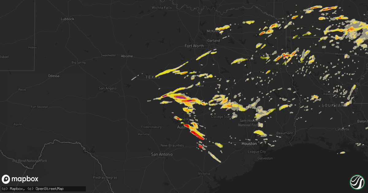
Hail Map on March 28, 2014
Get this storm
March 28 map
$229
one time, instant access
Download today. No call, no setup
Keep the $229
Bought the map and want the full workflow? Apply the entire $229 to a subscription within 7 days. None of it is wasted.
Every map, not just this one
This buys you this map. Subscription and you get every map we run, in the markets you choose from a few cities to whole states to nationwide. Plus real-time alerts the moment a storm fires.
Contact data
Name, contact info, occupancy, even credit band for addresses in the footprint. You go from where it hit to who to call.
Become the source they trust
Unlimited branding weather history reports on demand. You already have the documented answer ready for the property owner, and you are the one who showed up with it.
Property data and RoofTrace estimates
Pull up any address you have got, its value and the exact code rules for that jurisdiction, straight from One Click Code. Then RoofTrace estimates the squares, pitch, and roof value, priced the way you price.
States Impacted by Hail Map on March 28, 2014
Storm reports
Arkansas
| Date | Description |
|---|---|
| 03/28/20146:48 PM CDT | A tree fell into a house. |
| 03/28/20146:40 PM CDT | A local report indicates 1.75 inch wind near CAMDEN |
| 03/28/20146:39 PM CDT | A local report indicates 1.00 inch wind near 1 S MONTROSE |
| 03/28/20146:32 PM CDT | Occurred on macon lake rd |
| 03/28/20146:30 PM CDT | Trees down on highway 79 |
| 03/28/20146:30 PM CDT | About 10 power poles snapped at the base. Report via social media. Possible tornado |
| 03/28/20146:30 PM CDT | Numerous trees down |
| 03/28/20146:27 PM CDT | Quarter sized hail reported. |
| 03/28/20146:15 PM CDT | Report from social media |
| 03/28/20146:05 PM CDT | A local report indicates 1.75 inch wind near 1 N HAMBURG |
| 03/28/20146:02 PM CDT | A local report indicates 1.75 inch wind near HAMBURG |
| 03/28/20145:45 PM CDT | A local report indicates 1.00 inch wind near HOPE |
| 03/28/20145:40 PM CDT | Penny to quarter size hail was increasing in volume between collins and cominto along arkansas 35. |
| 03/28/20145:07 PM CDT | Quarter to golf ball sized hail covered the ground along ashley road 298. |
| 03/28/20144:59 PM CDT | Trees down...power lines down |
| 03/28/20144:41 PM CDT | Quarter size hail fell at green hill...which is 4 to 5 miles southwest of monticello... |
| 03/28/20144:17 PM CDT | Hail from quarter to half dollar size was beginning to cover the parking lot at the state police troop headquarters on the south side of warren. |
| 03/28/20144:13 PM CDT | A local report indicates 1.75 inch wind near WARREN |
| 03/28/20144:00 PM CDT | A local report indicates 1.00 inch wind near 7 W WARREN |
| 03/28/20143:50 PM CDT | Hail up to golf ball size hail fell...breaking windows in cars. |
| 03/28/20143:50 PM CDT | A local report indicates 1.00 inch wind near RISON |
| 03/28/20143:33 PM CDT | Hail from marble to golf ball size fell on u.s. 167 north of fordyce...near ivan. |
| 03/28/20143:33 PM CDT | Hail measured 2 1/4 inches in diameter between fordyce and ivan. Windshields were broken. |
| 03/28/20143:04 PM CDT | A local report indicates 1.75 inch wind near HOLLY SPRINGS |
| 03/28/20142:40 PM CDT | A local report indicates 1.00 inch wind near SPARKMAN |
| 03/27/20149:17 PM CDT | Straight line wind damage began near highway 65 just south of eudora where five power poles were snapped. Also damage was along grand lake loop where a large tree was s |
| 03/27/20149:17 PM CDT | Straight line wind damage began near highway 65 just south of eudora where five power poles were snapped. Also damage was along grand lake loop where a large tree was s |
| 03/27/20149:00 PM CDT | Dime to quarter size hail. Reported via social media. |
| 03/27/20148:59 PM CDT | Swath of straight line wind damage began near highway 165 between portland and parkdale. Eight wooden power poles were snapped off to the east along highway 165 south o |
| 03/27/20148:15 PM CDT | Reports of nickel to quarter size hail on king circle. Also a few tree limbs were blown down. |
| 03/27/20147:55 PM CDT | Several trees and power lines down |
| 03/27/20147:38 PM CDT | Trees were blown down on bradley county roads 5...32...and 41. |
| 03/27/20147:25 PM CDT | Storm chaser reported 60-70 mph inflow winds with a rain-wrapped funnel cloud to the east |
| 03/27/20147:10 PM CDT | Power lines downed at us 82 and us 65 |
| 03/27/20147:10 PM CDT | Half dollar size hail fell on south jackson ave near highway 167 south of el dorado. |
| 03/27/20147:10 PM CDT | A local report indicates 1.00 inch wind near LAKE VILLAGE |
| 03/27/20147:00 PM CDT | A local report indicates 1.00 inch wind near 8 NE EL DORADO |
Louisiana
| Date | Description |
|---|---|
| 03/28/20146:55 PM CDT | Trees down near jewela and penick |
| 03/28/20146:37 PM CDT | A local report indicates 1.75 inch wind near SHREVEPORT |
| 03/28/20146:32 PM CDT | Golfball size hail fell at the national weather service in shreveport. |
| 03/28/20146:30 PM CDT | Hail slightly larger than golfballs fell in west shreveport |
| 03/28/20146:30 PM CDT | Severe damage to mobile home and vehicle windows cracked on fawn lane |
| 03/28/20146:29 PM CDT | A local report indicates 60 MPH wind near 2 SW SHREVEPORT |
| 03/28/20146:26 PM CDT | Ping pong size hail at greenwook |
| 03/28/20146:05 PM CDT | A local report indicates 1.75 inch wind near GREENWOOD |
| 03/27/201410:45 PM CDT | Trees and power lines down |
| 03/27/201410:32 PM CDT | A few trees and power lines down...along hwy 3180 a metal roof was pealed off a home...close by a porch was blown off a mobile home. |
| 03/27/201410:30 PM CDT | Trees and power lines down. |
| 03/27/201410:25 PM CDT | Trees and power lines down across the parish. |
| 03/27/201410:15 PM CDT | Numerous trees and power lines down across the parish. More damage was noted across the southern portion of the parish. |
| 03/27/201410:00 PM CDT | Tree on a home. Numerous trees and powerlines down throughout the parish. |
| 03/27/201410:00 PM CDT | Evangeline parish oep reports trees and powerlines down in mamou south of hwy 104 and east of hwy 95 along vrangus. Evangeline sheriff deputy says possible tornado. |
| 03/27/201410:00 PM CDT | Trees and large limbs downed across the parish |
| 03/27/201410:00 PM CDT | Roofs damaged on several homes |
| 03/27/20149:45 PM CDT | Numerous trees and powerlines down throughout the parish |
| 03/27/20149:45 PM CDT | A local report indicates 1.00 inch wind near LAKE PROVIDENCE |
| 03/27/20149:25 PM CDT | A local report indicates 1.00 inch wind near 2 E DUBACH |
| 03/27/20149:19 PM CDT | Alexandria asos measured a wind gust of 67 mph. |
| 03/27/20149:15 PM CDT | Roof ripped off of a home. Widespread trees and powerlines down throughout the parish. |
| 03/27/20149:15 PM CDT | Around 50 large pine trees were downed near the intersection of hwy 165 and tall timbers lane. Many were snapped anywhere from 4 to 20 feet above ground. Some pines wer |
| 03/27/20149:15 PM CDT | Public reports large tree limbs down at louisiana college. |
| 03/27/20149:15 PM CDT | Ham radio operator reports wind gust of 60 mph. |
| 03/27/20149:12 PM CDT | Report from social media of hail a little bit bigger than quarter sized. Additional reports of hail in oak grove up to half dollar size. |
| 03/27/20149:10 PM CDT | Tree down on a home. Widespread trees and powerlines down |
| 03/27/20149:10 PM CDT | Dime to quarter sized hail along comeaux rd. |
| 03/27/20149:07 PM CDT | Observer reported tree down on house on elm street. |
| 03/27/20149:05 PM CDT | Travel trailer moved off its blocks |
| 03/27/20149:05 PM CDT | Tree down on shady grove road |
| 03/27/20149:00 PM CDT | Numerous trees and powerlines down on north side of black lake |
| 03/27/20148:57 PM CDT | Public reports golfball size hail in simpson. |
| 03/27/20148:50 PM CDT | Widespread trees and powerlines down throughout the parish |
| 03/27/20148:45 PM CDT | Widespread trees and powerlines down throughout the parish... Numerous trees on cars |
| 03/27/20148:40 PM CDT | Trees and powerlines down near cooper lake road and yeldell road. |
| 03/27/20148:30 PM CDT | Tree down on a vehicle trapping the occupants inside on many petty road near many high school. No injuries. |
| 03/27/20148:25 PM CDT | Widespread trees and powerlines down throughout the parish |
| 03/27/20148:20 PM CDT | Several trees on homes just north of zwolle. |
| 03/27/20148:20 PM CDT | Widespread trees and powerlines down |
| 03/27/20148:00 PM CDT | A local report indicates 1.75 inch wind near MARION |
| 03/27/20147:25 PM CDT | Numerous trees down |
| 03/27/20147:10 PM CDT | In fellowship community |
Oklahoma
| Date | Description |
|---|---|
| 03/28/20145:00 PM CDT | A local report indicates 1.25 inch wind near OKTAHA |
| 03/28/20145:00 PM CDT | A local report indicates 1.25 inch wind near OKTAHA |
| 03/28/20144:38 PM CDT | A local report indicates 1.25 inch wind near HITCHITA |
| 03/28/20143:55 PM CDT | A local report indicates 72 MPH wind near 5 WNW WESTVILLE |
| 03/28/20141:48 PM CDT | Reported through local media |
Florida
| Date | Description |
|---|---|
| 03/28/201411:25 AM CDT | Eglin afb asos reported gust of 58kts. |
| 03/28/201411:05 AM CDT | 70kt est. Wind gust in ft. Walton beach. Light damage to fences and utility shed. |
| 03/28/201411:00 AM CDT | 70kt est. Wind gust at ft. Walton beach. Light damage to fences and a utility shed. |
| 03/28/201411:00 AM CDT | Top part of wendys sign fell down... Trees down on mary esther library... Portable building leaning on a car at harborwalk village and top of harborwalk ampitheater fell do ( |
| 03/28/201411:00 AM CDT | Hurlburt field asos reported 60kt gusts between 11am and 1106am. |
| 03/28/201410:38 AM CDT | 50kt wind gust in western okaloosa county... S of i-10 along with power outages. |
| 03/28/201410:36 AM CDT | Glass windows blown out near belle mer condominium at 8269 gulf blvd. |
| 03/28/201410:36 AM CDT | Reports of a roof blown off a building at 1918 hwy 87 s at navarre beach. |
| 03/28/201410:00 AM CDT | Trained spotter reports tree branches down along gregory st. |
| 03/28/20149:57 AM CDT | Trained spotter reports 51kt wind gust near nas whiting field south... East of milton. |
| 03/28/20149:55 AM CDT | Santa rosa ems reports a tree limb on a house at 4120 price pl near bagdad. |
Texas
| Date | Description |
|---|---|
| 03/28/20146:57 PM CDT | A local report indicates 1.00 inch wind near LIVINGSTON |
| 03/28/20146:50 PM CDT | A local report indicates 1.00 inch wind near 4 SE FLATONIA |
| 03/28/20146:50 PM CDT | Numerous trees and power lines down across the county. |
| 03/28/20146:47 PM CDT | A local report indicates 1.00 inch wind near LONGVIEW |
| 03/28/20146:45 PM CDT | Numerous trees down |
| 03/28/20146:40 PM CDT | A local report indicates 1.00 inch wind near FLATONIA |
| 03/28/20146:40 PM CDT | Numerous trees down...power lines down county wide |
| 03/28/20146:25 PM CDT | Numerous trees and power lines down across the county |
| 03/28/20146:18 PM CDT | A local report indicates 1.00 inch wind near RUSK |
| 03/28/20146:15 PM CDT | Numerous trees down...power lines down |
| 03/28/20146:15 PM CDT | A local report indicates 1.00 inch wind near MOUNT PLEASANT |
| 03/28/20146:09 PM CDT | Most hailstones ranged from one half to three quarters of an inch |
| 03/28/20146:09 PM CDT | A local report indicates 1.25 inch wind near 4 SE SMITHVILLE |
| 03/28/20146:00 PM CDT | A local report indicates 1.00 inch wind near 5 NE MOUNT PLEASANT |
| 03/28/20146:00 PM CDT | Most hailstones ranged from one half to three quarters of an inch. It hailed for 15 minutes. |
| 03/28/20146:00 PM CDT | Baseballl size hail was reported in waskom tx. |
| 03/28/20145:57 PM CDT | Tree snapped and fence blown over |
| 03/28/20145:55 PM CDT | A local report indicates 1.00 inch wind near 4 ENE MADISONVILLE |
| 03/28/20145:51 PM CDT | Trees down |
| 03/28/20145:50 PM CDT | 1 inch hail and several trees down in wamba |
| 03/28/20145:50 PM CDT | 1 inch hail ans several trees down in wamba |
| 03/28/20145:49 PM CDT | Near intersection of fm31 and fm2625 |
| 03/28/20145:49 PM CDT | A local report indicates 1.00 inch wind near 4 ENE MADISONVILLE |
| 03/28/20145:45 PM CDT | A local report indicates 1.25 inch wind near MARSHALL |
| 03/28/20145:35 PM CDT | A local report indicates 1.75 inch wind near 4 W BASTROP |
| 03/28/20145:35 PM CDT | A local report indicates 65 MPH wind near CENTERVILLE |
| 03/28/20145:35 PM CDT | Large pine trees downed/damaged |
| 03/28/20145:35 PM CDT | Power lines downed and possible roof damage |
| 03/28/20145:33 PM CDT | A local report indicates 1.75 inch wind near 4 W BASTROP |
| 03/28/20145:30 PM CDT | A local report indicates 1.00 inch wind near BOGATA |
| 03/28/20145:30 PM CDT | A local report indicates 1.00 inch wind near 2 W BASTROP |
| 03/28/20145:30 PM CDT | One side of a building damaged in centerville due to strong winds. |
| 03/28/20145:28 PM CDT | A local report indicates 1.00 inch wind near 1 S DEPORT |
| 03/28/20145:27 PM CDT | Hilltop lakes |
| 03/28/20145:25 PM CDT | A local report indicates 1.75 inch wind near 12 W MADISONVILLE |
| 03/28/20145:25 PM CDT | A local report indicates 1.00 inch wind near 3 NNW BASTROP |
| 03/28/20145:24 PM CDT | A local report indicates 1.00 inch wind near 4 SW DEPORT |
| 03/28/20145:15 PM CDT | A local report indicates 1.75 inch wind near 7 SSW ELGIN |
| 03/28/20145:15 PM CDT | A local report indicates 1.00 inch wind near MARQUEZ |
| 03/28/20145:14 PM CDT | Hilltop lakes |
| 03/28/20145:06 PM CDT | A local report indicates 1.00 inch wind near EASTERLY |
| 03/28/20145:03 PM CDT | Elgin high school |
| 03/28/20145:01 PM CDT | A local report indicates 1.00 inch wind near CALVERT |
| 03/28/20144:52 PM CDT | A local report indicates 1.00 inch wind near 5 ENE AUSTIN |
| 03/28/20144:52 PM CDT | A local report indicates 1.00 inch wind near AUSTIN BERGSTROM INT AP |
| 03/28/20144:48 PM CDT | Trees down |
| 03/28/20144:48 PM CDT | 2 trees down accross highway |
| 03/28/20144:45 PM CDT | A local report indicates 1.00 inch wind near 7 NE AUSTIN |
| 03/28/20144:45 PM CDT | A local report indicates 1.00 inch wind near 5 ENE AUSTIN |
| 03/28/20144:45 PM CDT | A local report indicates 1.00 inch wind near 3 N ATHENS |
| 03/28/20144:45 PM CDT | A local report indicates 1.75 inch wind near 2 W MANOR |
| 03/28/20144:45 PM CDT | A local report indicates 1.00 inch wind near DAINGERFIELD |
| 03/28/20144:44 PM CDT | A local report indicates 1.75 inch wind near 5 NE AUSTIN |
| 03/28/20144:42 PM CDT | A local report indicates 1.75 inch wind near 4 NE AUSTIN |
| 03/28/20144:39 PM CDT | A local report indicates 1.25 inch wind near FERRIS |
| 03/28/20144:38 PM CDT | Nickel to quarter size hail |
| 03/28/20144:35 PM CDT | A local report indicates 1.00 inch wind near FERRIS |
| 03/28/20144:35 PM CDT | Hail stones ranging from pea size to one inch occurring on and off for more than five minutes |
| 03/28/20144:35 PM CDT | 1 inch hail at spicewood springs and mopac |
| 03/28/20144:34 PM CDT | Hail damaged vehicles from golfball size hail |
| 03/28/20144:33 PM CDT | A local report indicates 1.00 inch wind near 6 N AUSTIN |
| 03/28/20144:30 PM CDT | A local report indicates 1.75 inch wind near JOLLYVILLE |
| 03/28/20144:30 PM CDT | A local report indicates 1.00 inch wind near 4 N AUSTIN |
| 03/28/20144:30 PM CDT | A local report indicates 1.00 inch wind near 4 SSW WELLS BRANCH |
| 03/28/20144:22 PM CDT | A local report indicates 1.50 inch wind near CEDAR PARK |
| 03/28/20144:21 PM CDT | A local report indicates 1.75 inch wind near 1 NE CEDAR PARK |
| 03/28/20144:20 PM CDT | Hail covering the ground |
| 03/28/20144:18 PM CDT | Storm spotter reported 1 inch hail near fm569 and fm990 near simms tx. |
| 03/28/20144:15 PM CDT | A local report indicates 1.00 inch wind near BEN ARNOLD |
| 03/28/20144:15 PM CDT | A local report indicates 1.25 inch wind near 5 SW ANDERSON MILL |
| 03/28/20144:15 PM CDT | Windows blown out of one side of a house |
| 03/28/20144:10 PM CDT | A local report indicates 1.00 inch wind near RED OAK |
| 03/28/20144:05 PM CDT | A local report indicates 1.00 inch wind near WEIR |
| 03/28/20143:52 PM CDT | A local report indicates 1.00 inch wind near MIDLOTHIAN |
| 03/28/20143:52 PM CDT | A local report indicates 1.00 inch wind near BAILEY |
| 03/28/20143:50 PM CDT | A local report indicates 1.00 inch wind near CELESTE |
| 03/28/20143:49 PM CDT | A local report indicates 1.75 inch wind near 1 E JARRELL |
| 03/28/20143:45 PM CDT | *delayed report* hail damage to vehicles was reported along highway 190 in town. |
| 03/28/20143:44 PM CDT | Multiple houses in the dawson ranch subdivision had windows broken due to wind driven hail |
| 03/28/20143:42 PM CDT | At scott white hospital |
| 03/28/20143:42 PM CDT | At scott white hospital |
| 03/28/20143:41 PM CDT | A local report indicates 1.50 inch wind near BLUE RIDGE |
| 03/28/20143:35 PM CDT | A local report indicates 1.50 inch wind near SALADO |
| 03/28/20143:35 PM CDT | A local report indicates 1.25 inch wind near 4 W JARRELL |
| 03/28/20143:33 PM CDT | A local report indicates 1.00 inch wind near BLUE RIDGE |
| 03/28/20143:28 PM CDT | A local report indicates 1.75 inch wind near TEMPLE |
| 03/28/20143:26 PM CDT | Hwy 190 and 1570 |
| 03/28/20143:20 PM CDT | Intersection of hwys 36 and 360 |
| 03/28/20143:07 PM CDT | Khlr reported 58 knots |
| 03/28/20143:06 PM CDT | A local report indicates 1.50 inch wind near FORT HOOD |
| 03/28/20143:02 PM CDT | N side of 190 near fort hood |
| 03/28/20143:02 PM CDT | A local report indicates 1.50 inch wind near 1 SSE MERIDIAN |
| 03/28/20142:58 PM CDT | A local report indicates 1.50 inch wind near MERIDIAN |
| 03/28/20142:42 PM CDT | A local report indicates 1.75 inch wind near COPPERAS COVE |
| 03/28/20142:40 PM CDT | A local report indicates 1.50 inch wind near COPPERAS COVE |
| 03/28/20142:35 PM CDT | A local report indicates 1.00 inch wind near 17 NE TOW |
| 03/28/20142:34 PM CDT | A local report indicates 1.00 inch wind near LAMPASAS |
| 03/28/20142:23 PM CDT | A local report indicates 1.50 inch wind near 7 W GATESVILLE |
| 03/28/20141:58 PM CDT | A local report indicates 1.00 inch wind near 2 S HICO |
| 03/28/20141:21 PM CDT | Golf ball sized hail in lometa |
| 03/27/20148:27 PM CDT | Public estimates wind gust of 60-70 mph and small hail |
| 03/27/20148:26 PM CDT | Public reports hail varying in size between a quarter and half dollar size at the sonic in downtown jasper |
| 03/27/20148:23 PM CDT | Newton county sheriff reports trees down in burkeville and a car blown off the road. Time estimated by radar |
| 03/27/20148:20 PM CDT | Jasper county sheriff reports trees down along fm 1004 in kirbyville. |
| 03/27/20148:20 PM CDT | Jasper county sheriff reports trees down along fm 1013 in magnolia springs. |
| 03/27/20148:02 PM CDT | Public reports hail varying in size between a quarter and half dollar size at the sonic in downtown jasper |
| 03/27/20148:00 PM CDT | Widespread trees and powerlines down throughout the county |
| 03/27/20147:49 PM CDT | Two trees down at rv park. Wind estimated at 60 mph. |
| 03/27/20147:45 PM CDT | Widespread trees down throughout the county |
| 03/27/20147:45 PM CDT | Widespread trees and powerlines down...mainly across the southern half of the county |
| 03/27/20147:45 PM CDT | Tyler county sheriff reports numerous trees and powerlines down in woodville |
| 03/27/20147:42 PM CDT | A local report indicates 1.00 inch wind near 9 NE SPEAKS |
| 03/27/20147:36 PM CDT | Numerous trees down including one that fell on a vehicle along spring valley rd. Power has also been knocked out to the area hospital. |
| 03/27/20147:00 PM CDT | Trees down on various roads throughout walker county... Especially the northern part of the county. |
| 03/27/20147:00 PM CDT | Widespread trees down throughout the county |
| 03/27/20147:00 PM CDT | Widespread trees down throughout the county. Several trees on automobiles. |
Alabama
| Date | Description |
|---|---|
| 03/28/20141:57 AM CDT | Public report of 1 1/4 inch hail in satsuma... Al. |
Mississippi
| Date | Description |
|---|---|
| 03/27/201411:55 PM CDT | Quarter sized hail reported in holmesville area. |
| 03/27/201411:55 PM CDT | Garage door thrown into road in holmesville. |
| 03/27/201411:15 PM CDT | Quarter size hail fell on dinkins road. |
| 03/27/201411:15 PM CDT | Multiple trees down in the pleasant hill and union church area. A roof was also blown off of a house in blue hill. Dime size hail also occurred in the area. |
| 03/27/201411:10 PM CDT | Multiple trees were downed with one across veto road. |
| 03/27/201411:05 PM CDT | Some trees were down in meadville. |
| 03/27/201411:00 PM CDT | Tree down in port gibson. Report relayed via social media. |
| 03/27/201410:50 PM CDT | Multiple trees were downed in roxie. |
| 03/27/201410:50 PM CDT | Trees and power lines downed in the stampley area |
| 03/27/201410:40 PM CDT | Lawn furniture was blown through the window of a house along morgantown road |
| 03/27/201410:38 PM CDT | A tree fell on a house on martin luther king jr road |
| 03/27/201410:35 PM CDT | Tree downed on melrose montebello parkway |
| 03/27/20149:50 PM CDT | Relayed via social media. |
| 03/27/20147:37 PM CDT | Reported at ms highway 1 and ms highway 454 |
| 03/27/20147:30 PM CDT | A local report indicates 2.00 inch wind near 5 NNW AVON |
| 03/27/20147:25 PM CDT | 7 road off macedonia rd which connects to highway 6 has several trees down some of which took power lines down. A mobile home was blown off its foundation and several h |
| 03/27/20147:25 PM CDT | Several trees down which took down powers lines along curtis road and curtis-lockestation road. |
| 03/27/20147:25 PM CDT | 7 road off macedonia rd which connects to highway 6 has several trees down some of which took power lines down. A mobile home was blown off its foundation and several h |
| 03/27/20147:20 PM CDT | 7 road off macedonia rd which connects to highway 6 has several trees down some of which took power lines down. A mobile home was blown off its foundation and several h |
Cities Impacted by Hail Map on March 28, 2014
- Hollandale, MS
- Paron, AR
- Leland, MS
- Eudora, AR
- Greenville, MS
- Lake Village, AR
- Shreveport, LA
- Texarkana, AR
- Leesville, LA
- Blue Ridge, TX
- Leonard, TX
- Celeste, TX
- Farmersville, TX
- Wolfe City, TX
- Silver City, MS
- Tchula, MS
- Meridian, TX
- Anderson, TX
- Jarrell, TX
- Bartlett, TX
- Georgetown, TX
- Mansfield, LA
- Pelican, LA
- Bearden, AR
- Hampton, AR
- Thornton, AR
- Farmerville, LA
- Marion, LA
- Emerson, AR
- Bastrop, TX
- Cedar Creek, TX
- Big Sandy, TX
- Austin, TX
- Sterlington, LA
- Burlington, TX
- Rosebud, TX
- Cameron, TX
- Gatesville, TX
- Lampasas, TX
- Livingston, TX
- Waskom, TX
- Gilmer, TX
- Ferris, TX
- Lancaster, TX
- Red Oak, TX
- Bossier City, LA
- Midway, TX
- Huntsville, TX
- Temple, TX
- Little River Academy, TX
- Gibsland, LA
- Mount Pleasant, TX
- Omaha, TX
- Copperas Cove, TX
- Cleveland, TX
- Dayton, TX
- Camden, AR
- Valley Mills, TX
- Whitney, TX
- Clifton, TX
- Aquilla, TX
- Warren, AR
- Oktaha, OK
- Satsuma, AL
- Eight Mile, AL
- Saraland, AL
- Hope, AR
- Fulton, AR
- Rayville, LA
- Thrall, TX
- Dundee, MS
- Helena, AR
- Iredell, TX
- Richards, TX
- Bedias, TX
- Union Church, MS
- Trinity, TX
- Talco, TX
- McDade, TX
- Elgin, TX
- Naples, TX
- Marietta, TX
- Emmet, AR
- Sparkman, AR
- Kingsland, AR
- Fordyce, AR
- Ivan, AR
- Crossett, AR
- Hermitage, AR
- Marshall, TX
- Dublin, TX
- Arkadelphia, AR
- Gurdon, AR
- Magnolia, AR
- Kempner, TX
- Sealy, TX
- Maud, TX
- Canton, MS
- Madison, MS
- Huffman, TX
- New Caney, TX
- Porter, TX
- Portland, AR
- Montrose, AR
- Hamburg, AR
- Gilbert, LA
- Sicily Island, LA
- Texarkana, TX
- Jefferson, TX
- Jasper, TX
- Newton, TX
- Wiergate, TX
- Louise, MS
- Yazoo City, MS
- Simms, TX
- De Kalb, TX
- New Boston, TX
- Normangee, TX
- Penelope, TX
- Mount Calm, TX
- Douglass, TX
- Nacogdoches, TX
- Monticello, AR
- Oakwood, TX
- Bethany, LA
- Jewett, TX
- Rolling Fork, MS
- Valley Park, MS
- Mayersville, MS
- Jamestown, LA
- Castor, LA
- Huttig, AR
- Pineville, LA
- Deville, LA
- Coupland, TX
- Flatonia, TX
- Schulenburg, TX
- San Saba, TX
- Nevada, TX
- Killeen, TX
- Bogata, TX
- Deport, TX
- Pattonville, TX
- Paris, TX
- Greenwood, LA
- Dubberly, LA
- Caldwell, TX
- Louise, TX
- Strong, AR
- El Dorado, AR
- Durant, MS
- Salado, TX
- Lometa, TX
- Harker Heights, TX
- Florence, TX
- Crawford, TX
- Belton, TX
- Oglesby, TX
- Granger, TX
- Nolanville, TX
- Evant, TX
- Holland, TX
- Bend, TX
- Lott, TX
- Troy, TX
- Rogers, TX
- Fort Hood, TX
- McGregor, TX
- Hearne, TX
- Gause, TX
- Carlton, TX
- Gustine, TX
- Glen Rose, TX
- Hico, TX
- Blanket, TX
- Nemo, TX
- Walnut Springs, TX
- Comanche, TX
- Oak Grove, LA
- Muldoon, TX
- Sallis, MS
- Faunsdale, AL
- Uniontown, AL
- Marquez, TX
- Franklin, TX
- Mexia, TX
- Wortham, TX
- Smithville, TX
- Coolidge, TX
- Hubbard, TX
- Dawson, TX
- Lufkin, TX
- Midlothian, TX
- Waxahachie, TX
- North Zulch, TX
- Bryan, TX
- Madisonville, TX
- Princeton, TX
- Burkeville, TX
- Deridder, LA
- Mount Enterprise, TX
- Long Branch, TX
- Coushatta, LA
- Lexa, AR
- Vidalia, LA
- Marksville, LA
- Cleburne, TX
- Anguilla, MS
- Vicksburg, MS
- Sondheimer, LA
- Ringgold, LA
- Pickens, MS
- Benton, MS
- Lexington, MS
- Kosciusko, MS
- Carthage, MS
- Centerville, TX
- Leona, TX
- Palestine, TX
- Hooks, TX
- Abbott, TX
- Baytown, TX
- Belzoni, MS
- Isola, MS
- Annona, TX
- Avery, TX
- Georgetown, LA
- Barksdale Afb, LA
- Jena, LA
- Vian, OK
- Winnfield, LA
- Atlanta, LA
- Dry Prong, LA
- Wallisville, TX
- Liberty, TX
- Manor, TX
- La Grange, TX
- Giddings, TX
- Wilmar, AR
- Banks, AR
- Minden, LA
- Sibley, LA
- Doyline, LA
- West Point, TX
- Eufaula, OK
- Colmesneil, TX
- Washington, AR
- Ozan, AR
- Prescott, AR
- Leander, TX
- Council Hill, OK
- Columbia, LA
- West Helena, AR
- Sledge, MS
- Woodville, TX
- Lincoln, TX
- Paige, TX
- Lexington, TX
- Lafayette, LA
- Moscow, TX
- Athens, TX
- Eustace, TX
- Henryetta, OK
- Okmulgee, OK
- Daingerfield, TX
- Hughes Springs, TX
- Spearsville, LA
- Lovelady, TX
- Cookville, TX
- Huntington, TX
- Garrison, TX
- Timpson, TX
- Jones, LA
- Venus, TX
- Alvarado, TX
- Grandview, TX
- Desoto, TX
- Transylvania, LA
- Lake Providence, LA
- Carthage, TX
- Malvern, AR
- Traskwood, AR
- Winnie, TX
- Glen Allan, MS
- Mooringsport, LA
- Singer, LA
- Carthage, AR
- Rison, AR
- Pittsburg, TX
- Coldspring, TX
- Brewton, AL
- West, TX
- Crockett, TX
- Wilmot, AR
- Plain Dealing, LA
- Morganza, LA
- Gonzales, LA
- Prairieville, LA
- Chireno, TX
- Plaquemine, LA
- Saint Gabriel, LA
- White Castle, LA
- Carville, LA
- Murchison, TX
- Tallulah, LA
- Frisco City, AL
- Cedar Park, TX
- Keithville, LA
- Anahuac, TX
- Sheridan, AR
- Benton, AR
- Mangham, LA
- Oak Ridge, LA
- Brownsboro, TX
- Ben Wheeler, TX
- Hemphill, TX
- Charleston, MS
- Goodrich, TX
- Bastrop, LA
- Dermott, AR
- Jersey, AR
- Parkdale, AR
- Chatham, MS
- Fountain Hill, AR
- Bonita, LA
- Mer Rouge, LA
- Pioneer, LA
- Indianola, MS
- McCool, MS
- Rusk, TX
- Camden, MS
- Rohwer, AR
- Newellton, LA
- Crenshaw, MS
- Sardis, MS
- Coahoma, MS
- Ore City, TX
- Groveton, TX
- Eagle Lake, TX
- Calvert, TX
- Bremond, TX
- Cat Spring, TX
- Alleyton, TX
- Columbus, TX
- Alto, TX
- Seminole, OK
- Marks, MS
- Poplar Grove, AR
- Linden, TX
- Karnack, TX
- Fairfield, TX
- Stonewall, LA
- Gloster, LA
- Hallettsville, TX
- De Berry, TX
- Keatchie, LA
- Morgan, TX
- Taylor, TX
- Hutto, TX
- Clarendon, AR
- Casscoe, AR
- Longview, TX
- Cranfills Gap, TX
- Breaux Bridge, LA
- Mount Holly, AR
- Converse, LA
- Holly Grove, AR
- Marvell, AR
- Simmesport, LA
- Moreauville, LA
- Valera, TX
- Coleman, TX
- Sublime, TX
- El Campo, TX
- Garwood, TX
- Saline, LA
- Mckinney, TX
- Anna, TX
- Melissa, TX
- Stephens, AR
- Lewisville, AR
- Theodore, AL
- Mobile, AL
- Kilgore, TX
- Monterey, LA
- Jonesville, LA
- Aubrey, AR
- Apple Springs, TX
- Pollock, LA
- Natchez, MS
- Jacksonville, TX
- Houston, TX
- Dubach, LA
- Lettsworth, LA
- Plaucheville, LA
- Groesbeck, TX
- Kelly, LA
- Grayson, LA
- Olla, LA
- Moulton, TX
- Daphne, AL
- Bay Minette, AL
- Itasca, TX
- Milford, TX
- Hineston, LA
- Fort Polk, LA
- Pitkin, LA
- Batesville, MS
- Greenville, TX
- Commerce, TX
- Saint Landry, LA
- Beaumont, TX
- Danville, AR
- Ashdown, AR
- Creola, AL
- Semmes, AL
- Laneville, TX
- Kosse, TX
- Malone, TX
- Milam, TX
- San Augustine, TX
- Bronson, TX
- Devers, TX
- Bertram, TX
- Heflin, LA
- Winnsboro, LA
- Seagoville, TX
- Campti, LA
- Hot Springs National Park, AR
- Kirbyville, TX
- Weleetka, OK
- Lake Creek, TX
- Cooper, TX
- Brookshire, TX
- Waller, TX
- Beckville, TX
- Tatum, TX
- Pleasant Hill, LA
- Marthaville, LA
- Robeline, LA
- Bienville, LA
- Merigold, MS
- Franklin, LA
- Tyler, TX
- Harrell, AR
- Summerfield, LA
- Haynesville, LA
- Bernice, LA
- Hockley, TX
- Katy, TX
- Center Point, LA
- Milton, FL
- Jay, FL
- Royse City, TX
- Caddo Mills, TX
- Brookeland, TX
- Broaddus, TX
- Lillie, LA
- Junction City, AR
- Sikes, LA
- Dodson, LA
- Stockton, AL
- Hallsville, TX
- Vaughan, MS
- Chatham, LA
- Corrigan, TX
- Chunchula, AL
- Rosedale, MS
- Waco, TX
- Hot Springs Village, AR
- New Edinburg, AR
- Zavalla, TX
- Goldthwaite, TX
- Weimar, TX
- Elm Grove, LA
- Hempstead, TX
- Wilmer, TX
- Princeton, LA
- Haughton, LA
- Harrisonburg, LA
- Roe, AR
- Highlands, TX
- Crosby, TX
- Denham Springs, LA
- Baton Rouge, LA
- Henderson, TX
- Enterprise, LA
- Taylor, AR
- Shepherd, TX
- Thornton, TX
- Chandler, TX
- Frankston, TX
- Rosepine, LA
- Kingwood, TX
- Tullos, LA
- Buffalo, TX
- Ruleville, MS
- Homer, LA
- Cottonport, LA
- Mansura, LA
- West Monroe, LA
- Merryville, LA
- Evans, LA
- Wisner, LA
- Effie, LA
- Watson, AR
- Gunnison, MS
- Jonesboro, LA
- Iola, TX
- Axtell, TX
- Cushing, TX
- Liberty, MS
- Muskogee, OK
- Mamou, LA
- Eunice, LA
- Pecan Gap, TX
- Ladonia, TX
- Springhill, LA
- Marble Falls, TX
- Onalaska, TX
- Atmore, AL
- Jeanerette, LA
- Dequincy, LA
- Buckner, AR
- Stamps, AR
- Warren, TX
- Waelder, TX
- Malakoff, TX
- Colfax, LA
- Alexandria, LA
- Boyce, LA
- Oakdale, LA
- Fayetteville, AR
- Acme, LA
- Patterson, LA
- Baskin, LA
- Dauphin Island, AL
- Church Point, LA
- Monroeville, AL
- Walker, LA
- Benton, LA
- Woodway, TX
- Monroe, LA
- Delhi, LA
- Lorman, MS
- Pattison, MS
- Slidell, LA
- Fulshear, TX
- Bradley, AR
- Morris, OK
- Boynton, OK
- Purmela, TX