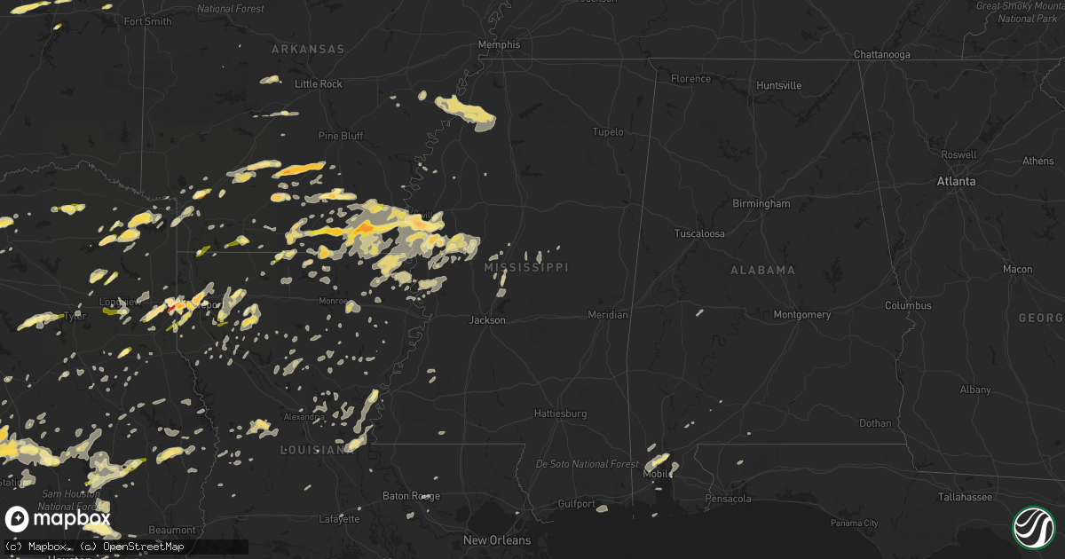
Hail Map in Mississippi on March 28, 2014
Get this storm
March 28 map
$229
one time, instant access
Download today. No call, no setup
Keep the $229
Bought the map and want the full workflow? Apply the entire $229 to a subscription within 7 days. None of it is wasted.
Every map, not just this one
This buys you this map. Subscription and you get every map we run, in the markets you choose from a few cities to whole states to nationwide. Plus real-time alerts the moment a storm fires.
Contact data
Name, contact info, occupancy, even credit band for addresses in the footprint. You go from where it hit to who to call.
Become the source they trust
Unlimited branding weather history reports on demand. You already have the documented answer ready for the property owner, and you are the one who showed up with it.
Property data and RoofTrace estimates
Pull up any address you have got, its value and the exact code rules for that jurisdiction, straight from One Click Code. Then RoofTrace estimates the squares, pitch, and roof value, priced the way you price.
Storm reports in Mississippi
Mississippi
| Date | Description |
|---|---|
| 03/27/201411:55 PM CDT | Garage door thrown into road in holmesville. |
| 03/27/201411:55 PM CDT | Quarter sized hail reported in holmesville area. |
| 03/27/201411:15 PM CDT | Multiple trees down in the pleasant hill and union church area. A roof was also blown off of a house in blue hill. Dime size hail also occurred in the area. |
| 03/27/201411:15 PM CDT | Quarter size hail fell on dinkins road. |
| 03/27/201411:10 PM CDT | Multiple trees were downed with one across veto road. |
| 03/27/201411:05 PM CDT | Some trees were down in meadville. |
| 03/27/201411:00 PM CDT | Tree down in port gibson. Report relayed via social media. |
| 03/27/201410:50 PM CDT | Multiple trees were downed in roxie. |
| 03/27/201410:50 PM CDT | Trees and power lines downed in the stampley area |
| 03/27/201410:40 PM CDT | Lawn furniture was blown through the window of a house along morgantown road |
| 03/27/201410:38 PM CDT | A tree fell on a house on martin luther king jr road |
| 03/27/201410:35 PM CDT | Tree downed on melrose montebello parkway |
| 03/27/20149:50 PM CDT | Relayed via social media. |
| 03/27/20147:37 PM CDT | Reported at ms highway 1 and ms highway 454 |
| 03/27/20147:30 PM CDT | A local report indicates 2.00 inch wind near 5 NNW AVON |
| 03/27/20147:25 PM CDT | 7 road off macedonia rd which connects to highway 6 has several trees down some of which took power lines down. A mobile home was blown off its foundation and several h |
| 03/27/20147:25 PM CDT | 7 road off macedonia rd which connects to highway 6 has several trees down some of which took power lines down. A mobile home was blown off its foundation and several h |
| 03/27/20147:25 PM CDT | Several trees down which took down powers lines along curtis road and curtis-lockestation road. |
| 03/27/20147:20 PM CDT | 7 road off macedonia rd which connects to highway 6 has several trees down some of which took power lines down. A mobile home was blown off its foundation and several h |
All States Impacted by Hail Map on March 28, 2014
Cities Impacted by Hail Map on March 28, 2014
- Hollandale, MS
- Paron, AR
- Leland, MS
- Eudora, AR
- Greenville, MS
- Lake Village, AR
- Shreveport, LA
- Texarkana, AR
- Leesville, LA
- Blue Ridge, TX
- Leonard, TX
- Celeste, TX
- Farmersville, TX
- Wolfe City, TX
- Silver City, MS
- Tchula, MS
- Meridian, TX
- Anderson, TX
- Jarrell, TX
- Bartlett, TX
- Georgetown, TX
- Mansfield, LA
- Pelican, LA
- Bearden, AR
- Hampton, AR
- Thornton, AR
- Farmerville, LA
- Marion, LA
- Emerson, AR
- Bastrop, TX
- Cedar Creek, TX
- Big Sandy, TX
- Austin, TX
- Sterlington, LA
- Burlington, TX
- Rosebud, TX
- Cameron, TX
- Gatesville, TX
- Lampasas, TX
- Livingston, TX
- Waskom, TX
- Gilmer, TX
- Ferris, TX
- Lancaster, TX
- Red Oak, TX
- Bossier City, LA
- Midway, TX
- Huntsville, TX
- Temple, TX
- Little River Academy, TX
- Gibsland, LA
- Mount Pleasant, TX
- Omaha, TX
- Copperas Cove, TX
- Cleveland, TX
- Dayton, TX
- Camden, AR
- Valley Mills, TX
- Whitney, TX
- Clifton, TX
- Aquilla, TX
- Warren, AR
- Oktaha, OK
- Satsuma, AL
- Eight Mile, AL
- Saraland, AL
- Hope, AR
- Fulton, AR
- Rayville, LA
- Thrall, TX
- Dundee, MS
- Helena, AR
- Iredell, TX
- Richards, TX
- Bedias, TX
- Union Church, MS
- Trinity, TX
- Talco, TX
- McDade, TX
- Elgin, TX
- Naples, TX
- Marietta, TX
- Emmet, AR
- Sparkman, AR
- Kingsland, AR
- Fordyce, AR
- Ivan, AR
- Crossett, AR
- Hermitage, AR
- Marshall, TX
- Dublin, TX
- Arkadelphia, AR
- Gurdon, AR
- Magnolia, AR
- Kempner, TX
- Sealy, TX
- Maud, TX
- Canton, MS
- Madison, MS
- Huffman, TX
- New Caney, TX
- Porter, TX
- Portland, AR
- Montrose, AR
- Hamburg, AR
- Gilbert, LA
- Sicily Island, LA
- Texarkana, TX
- Jefferson, TX
- Jasper, TX
- Newton, TX
- Wiergate, TX
- Louise, MS
- Yazoo City, MS
- Simms, TX
- De Kalb, TX
- New Boston, TX
- Normangee, TX
- Penelope, TX
- Mount Calm, TX
- Douglass, TX
- Nacogdoches, TX
- Monticello, AR
- Oakwood, TX
- Bethany, LA
- Jewett, TX
- Rolling Fork, MS
- Valley Park, MS
- Mayersville, MS
- Jamestown, LA
- Castor, LA
- Huttig, AR
- Pineville, LA
- Deville, LA
- Coupland, TX
- Flatonia, TX
- Schulenburg, TX
- San Saba, TX
- Nevada, TX
- Killeen, TX
- Bogata, TX
- Deport, TX
- Pattonville, TX
- Paris, TX
- Greenwood, LA
- Dubberly, LA
- Caldwell, TX
- Louise, TX
- Strong, AR
- El Dorado, AR
- Durant, MS
- Salado, TX
- Lometa, TX
- Harker Heights, TX
- Florence, TX
- Crawford, TX
- Belton, TX
- Oglesby, TX
- Granger, TX
- Nolanville, TX
- Evant, TX
- Holland, TX
- Bend, TX
- Lott, TX
- Troy, TX
- Rogers, TX
- Fort Hood, TX
- McGregor, TX
- Hearne, TX
- Gause, TX
- Carlton, TX
- Gustine, TX
- Glen Rose, TX
- Hico, TX
- Blanket, TX
- Nemo, TX
- Walnut Springs, TX
- Comanche, TX
- Oak Grove, LA
- Muldoon, TX
- Sallis, MS
- Faunsdale, AL
- Uniontown, AL
- Marquez, TX
- Franklin, TX
- Mexia, TX
- Wortham, TX
- Smithville, TX
- Coolidge, TX
- Hubbard, TX
- Dawson, TX
- Lufkin, TX
- Midlothian, TX
- Waxahachie, TX
- North Zulch, TX
- Bryan, TX
- Madisonville, TX
- Princeton, TX
- Burkeville, TX
- Deridder, LA
- Mount Enterprise, TX
- Long Branch, TX
- Coushatta, LA
- Lexa, AR
- Vidalia, LA
- Marksville, LA
- Cleburne, TX
- Anguilla, MS
- Vicksburg, MS
- Sondheimer, LA
- Ringgold, LA
- Pickens, MS
- Benton, MS
- Lexington, MS
- Kosciusko, MS
- Carthage, MS
- Centerville, TX
- Leona, TX
- Palestine, TX
- Hooks, TX
- Abbott, TX
- Baytown, TX
- Belzoni, MS
- Isola, MS
- Annona, TX
- Avery, TX
- Georgetown, LA
- Barksdale Afb, LA
- Jena, LA
- Vian, OK
- Winnfield, LA
- Atlanta, LA
- Dry Prong, LA
- Wallisville, TX
- Liberty, TX
- Manor, TX
- La Grange, TX
- Giddings, TX
- Wilmar, AR
- Banks, AR
- Minden, LA
- Sibley, LA
- Doyline, LA
- West Point, TX
- Eufaula, OK
- Colmesneil, TX
- Washington, AR
- Ozan, AR
- Prescott, AR
- Leander, TX
- Council Hill, OK
- Columbia, LA
- West Helena, AR
- Sledge, MS
- Woodville, TX
- Lincoln, TX
- Paige, TX
- Lexington, TX
- Lafayette, LA
- Moscow, TX
- Athens, TX
- Eustace, TX
- Henryetta, OK
- Okmulgee, OK
- Daingerfield, TX
- Hughes Springs, TX
- Spearsville, LA
- Lovelady, TX
- Cookville, TX
- Huntington, TX
- Garrison, TX
- Timpson, TX
- Jones, LA
- Venus, TX
- Alvarado, TX
- Grandview, TX
- Desoto, TX
- Transylvania, LA
- Lake Providence, LA
- Carthage, TX
- Malvern, AR
- Traskwood, AR
- Winnie, TX
- Glen Allan, MS
- Mooringsport, LA
- Singer, LA
- Carthage, AR
- Rison, AR
- Pittsburg, TX
- Coldspring, TX
- Brewton, AL
- West, TX
- Crockett, TX
- Wilmot, AR
- Plain Dealing, LA
- Morganza, LA
- Gonzales, LA
- Prairieville, LA
- Chireno, TX
- Plaquemine, LA
- Saint Gabriel, LA
- White Castle, LA
- Carville, LA
- Murchison, TX
- Tallulah, LA
- Frisco City, AL
- Cedar Park, TX
- Keithville, LA
- Anahuac, TX
- Sheridan, AR
- Benton, AR
- Mangham, LA
- Oak Ridge, LA
- Brownsboro, TX
- Ben Wheeler, TX
- Hemphill, TX
- Charleston, MS
- Goodrich, TX
- Bastrop, LA
- Dermott, AR
- Jersey, AR
- Parkdale, AR
- Chatham, MS
- Fountain Hill, AR
- Bonita, LA
- Mer Rouge, LA
- Pioneer, LA
- Indianola, MS
- McCool, MS
- Rusk, TX
- Camden, MS
- Rohwer, AR
- Newellton, LA
- Crenshaw, MS
- Sardis, MS
- Coahoma, MS
- Ore City, TX
- Groveton, TX
- Eagle Lake, TX
- Calvert, TX
- Bremond, TX
- Cat Spring, TX
- Alleyton, TX
- Columbus, TX
- Alto, TX
- Seminole, OK
- Marks, MS
- Poplar Grove, AR
- Linden, TX
- Karnack, TX
- Fairfield, TX
- Stonewall, LA
- Gloster, LA
- Hallettsville, TX
- De Berry, TX
- Keatchie, LA
- Morgan, TX
- Taylor, TX
- Hutto, TX
- Clarendon, AR
- Casscoe, AR
- Longview, TX
- Cranfills Gap, TX
- Breaux Bridge, LA
- Mount Holly, AR
- Converse, LA
- Holly Grove, AR
- Marvell, AR
- Simmesport, LA
- Moreauville, LA
- Valera, TX
- Coleman, TX
- Sublime, TX
- El Campo, TX
- Garwood, TX
- Saline, LA
- Mckinney, TX
- Anna, TX
- Melissa, TX
- Stephens, AR
- Lewisville, AR
- Theodore, AL
- Mobile, AL
- Kilgore, TX
- Monterey, LA
- Jonesville, LA
- Aubrey, AR
- Apple Springs, TX
- Pollock, LA
- Natchez, MS
- Jacksonville, TX
- Houston, TX
- Dubach, LA
- Lettsworth, LA
- Plaucheville, LA
- Groesbeck, TX
- Kelly, LA
- Grayson, LA
- Olla, LA
- Moulton, TX
- Daphne, AL
- Bay Minette, AL
- Itasca, TX
- Milford, TX
- Hineston, LA
- Fort Polk, LA
- Pitkin, LA
- Batesville, MS
- Greenville, TX
- Commerce, TX
- Saint Landry, LA
- Beaumont, TX
- Danville, AR
- Ashdown, AR
- Creola, AL
- Semmes, AL
- Laneville, TX
- Kosse, TX
- Malone, TX
- Milam, TX
- San Augustine, TX
- Bronson, TX
- Devers, TX
- Bertram, TX
- Heflin, LA
- Winnsboro, LA
- Seagoville, TX
- Campti, LA
- Hot Springs National Park, AR
- Kirbyville, TX
- Weleetka, OK
- Lake Creek, TX
- Cooper, TX
- Brookshire, TX
- Waller, TX
- Beckville, TX
- Tatum, TX
- Pleasant Hill, LA
- Marthaville, LA
- Robeline, LA
- Bienville, LA
- Merigold, MS
- Franklin, LA
- Tyler, TX
- Harrell, AR
- Summerfield, LA
- Haynesville, LA
- Bernice, LA
- Hockley, TX
- Katy, TX
- Center Point, LA
- Milton, FL
- Jay, FL
- Royse City, TX
- Caddo Mills, TX
- Brookeland, TX
- Broaddus, TX
- Lillie, LA
- Junction City, AR
- Sikes, LA
- Dodson, LA
- Stockton, AL
- Hallsville, TX
- Vaughan, MS
- Chatham, LA
- Corrigan, TX
- Chunchula, AL
- Rosedale, MS
- Waco, TX
- Hot Springs Village, AR
- New Edinburg, AR
- Zavalla, TX
- Goldthwaite, TX
- Weimar, TX
- Elm Grove, LA
- Hempstead, TX
- Wilmer, TX
- Princeton, LA
- Haughton, LA
- Harrisonburg, LA
- Roe, AR
- Highlands, TX
- Crosby, TX
- Denham Springs, LA
- Baton Rouge, LA
- Henderson, TX
- Enterprise, LA
- Taylor, AR
- Shepherd, TX
- Thornton, TX
- Chandler, TX
- Frankston, TX
- Rosepine, LA
- Kingwood, TX
- Tullos, LA
- Buffalo, TX
- Ruleville, MS
- Homer, LA
- Cottonport, LA
- Mansura, LA
- West Monroe, LA
- Merryville, LA
- Evans, LA
- Wisner, LA
- Effie, LA
- Watson, AR
- Gunnison, MS
- Jonesboro, LA
- Iola, TX
- Axtell, TX
- Cushing, TX
- Liberty, MS
- Muskogee, OK
- Mamou, LA
- Eunice, LA
- Pecan Gap, TX
- Ladonia, TX
- Springhill, LA
- Marble Falls, TX
- Onalaska, TX
- Atmore, AL
- Jeanerette, LA
- Dequincy, LA
- Buckner, AR
- Stamps, AR
- Warren, TX
- Waelder, TX
- Malakoff, TX
- Colfax, LA
- Alexandria, LA
- Boyce, LA
- Oakdale, LA
- Fayetteville, AR
- Acme, LA
- Patterson, LA
- Baskin, LA
- Dauphin Island, AL
- Church Point, LA
- Monroeville, AL
- Walker, LA
- Benton, LA
- Woodway, TX
- Monroe, LA
- Delhi, LA
- Lorman, MS
- Pattison, MS
- Slidell, LA
- Fulshear, TX
- Bradley, AR
- Morris, OK
- Boynton, OK
- Purmela, TX


