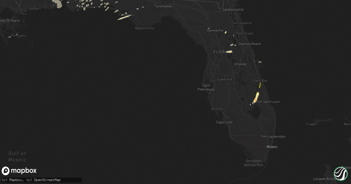
Hail Map in Florida on March 24, 2016
Get this storm
March 24 map
$229
one time, instant access
Download today. No call, no setup
Keep the $229
Bought the map and want the full workflow? Apply the entire $229 to a subscription within 7 days. None of it is wasted.
Every map, not just this one
This buys you this map. Subscription and you get every map we run, in the markets you choose from a few cities to whole states to nationwide. Plus real-time alerts the moment a storm fires.
Contact data
Name, contact info, occupancy, even credit band for addresses in the footprint. You go from where it hit to who to call.
Become the source they trust
Unlimited branding weather history reports on demand. You already have the documented answer ready for the property owner, and you are the one who showed up with it.
Property data and RoofTrace estimates
Pull up any address you have got, its value and the exact code rules for that jurisdiction, straight from One Click Code. Then RoofTrace estimates the squares, pitch, and roof value, priced the way you price.
Storm reports in Florida
Florida
| Date | Description |
|---|---|
| 03/24/20166:30 PM CDT | Emergency manager reported trees down across the county. One tree is down at birschbach way near deerlake w. Another tree was reported down on power lines at thomasvill |
| 03/24/20165:52 PM CDT | 1 large tree and several smaller trees downed just north of the intersection of lyons rd and hammock blvd. Time estimated via radar. |
| 03/24/20165:00 PM CDT | Roof damage to a structure in greenwood during the march 24th storms. |
| 03/24/20164:40 PM CDT | Several residents in southern palm bay near grant road and babcock street sent in photos and videos of hail up to the size of quarters. |
| 03/24/20164:06 PM CDT | Trees were blown down on kylea laird road during the march 24th storms. |
| 03/24/20164:06 PM CDT | A storm spotter estimated 60 mph winds in freeport. |
| 03/24/20163:39 PM CDT | Power pole down on forest rd north of rocky bayou. Report via social media. |
| 03/24/20163:31 PM CDT | Okeechobee county fire rescue station 4 at the intersection of us-441 and ne 168th street reported golf ball sized hail. Time estimated using radar. |
| 03/24/20163:25 PM CDT | Two trees were blown down near phillips road and highway 83 during the march 24th storms |
| 03/24/20162:45 PM CDT | Report of quarter sized hail on the campus of university of west florida via social media. |
| 03/24/20165:37 AM CDT | Reported on highway 22 near callaway. Forwarded by a wjhg-tv meteorologist. |
| 03/24/20165:35 AM CDT | A tree and power line were blown down into the roadway during an early morning storm on march 25th |
| 03/23/201611:30 PM CDT | 14 mobile homes damaged with some sheet metal peeled off roofs and porches. |
| 03/23/20169:49 PM CDT | Broadcast media sent pictures of metal roof of a barn torn off in baldwin. |
| 03/23/20169:49 PM CDT | Wjxt news reports that five barns on a farm were destroyed by an apparent downburst as thunderstorms moved through the baldwin area late on thursday evening. A tin roof |
| 03/23/20169:45 PM CDT | Central dispatch reported a large branch fell through a roof and into the living room of a residence in gainesville. No injuries reported. Other large branches were rep |
| 03/23/20169:32 PM CDT | Central dispatch reported trees down in the city of alachua. |
| 03/23/20169:25 PM CDT | Central dispatch reported branches and trees down near micanopy. |
| 03/23/20168:00 PM CDT | Tree fell over a power line on jody morgan grade near the beaches during the march 24th storms |
| 03/23/20167:55 PM CDT | Tree down on highway 221 about 6 miles north of perry during march 24th storms |
| 03/23/20167:46 PM CDT | A tree blew down close to the outside eastbound lane of i-10 during the march 24th storms. |
| 03/23/20167:15 PM CDT | A tree blew down in the road near the intersection of sr-30 and sr-59 during the march 24th storms. |
| 03/23/20167:08 PM CDT | Report of downed tree on cemetery road near woodville highway during march 24th storms |
| 03/23/20167:04 PM CDT | One tree downed on i-10. |
All States Impacted by Hail Map on March 24, 2016
Cities Impacted by Hail Map on March 24, 2016
- Niceville, FL
- Okeechobee, FL
- Inlet Beach, FL
- Panama City Beach, FL
- Panama City, FL
- Interlachen, FL
- Hawthorne, FL
- Eglin Afb, FL
- Pensacola, FL
- Brewton, AL
- Cantonment, FL
- Umatilla, FL
- Leesburg, FL
- Miramar Beach, FL
- Titusville, FL
- Pomona Park, FL
- Perdido, AL
- Milton, FL
- Elberta, AL
- Robertsdale, AL
- Lady Lake, FL
- Weirsdale, FL
- Grand Island, FL
- Altoona, FL
- Astor, FL
- Mobile, AL
- Flomaton, AL
- Eight Mile, AL
- Blountstown, FL
- Castleberry, AL
- Wilmer, AL
- Navarre, FL
- Destin, FL
- Bagdad, FL
- Cottonwood, AL
- Chunchula, AL
- Baker, FL
- Clarksville, FL
- Crestview, FL
- Laurel Hill, FL
- Lynn Haven, FL
- Fort Walton Beach, FL
- Mary Esther, FL
- Hurlburt Field, FL
- Lillian, AL
- Fairhope, AL
- Daphne, AL
- Andalusia, AL
- Port Sulphur, LA
- Defuniak Springs, FL
- Vero Beach, FL
- Holt, FL
- Fort McCoy, FL
- Montegut, LA
- Chauvin, LA
- Loxley, AL
- Elba, AL
- Samson, AL
- Enterprise, AL
- Kinston, AL
- New Brockton, AL
- Newberry, FL
- Alachua, FL
- Bayou La Batre, AL
- Semmes, AL
- Coden, AL
- Grand Bay, AL
- Moss Point, MS
- Lucedale, MS
- Irvington, AL
- Theodore, AL
- Freeport, FL
- Atmore, AL
- Golden Meadow, LA
- Gulf Breeze, FL
- Columbia, AL
- Troy, AL
- Fellsmere, FL
- Palm Bay, FL


