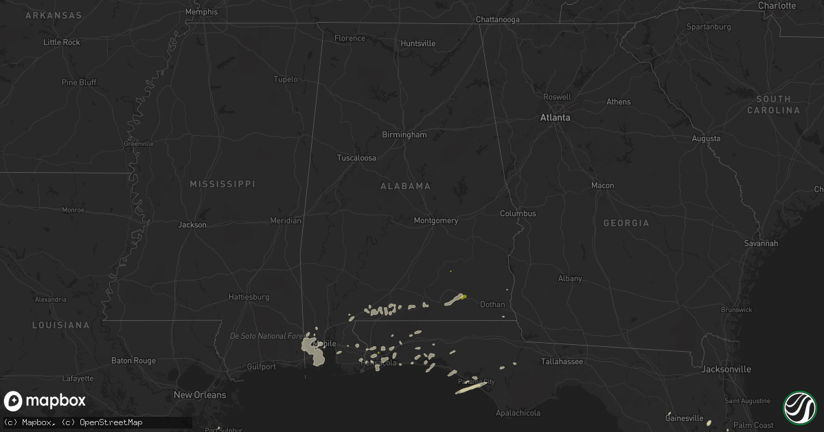
Hail Map in Alabama on March 24, 2016
Get this storm
March 24 map
$229
one time, instant access
Download today. No call, no setup
Keep the $229
Bought the map and want the full workflow? Apply the entire $229 to a subscription within 7 days. None of it is wasted.
Every map, not just this one
This buys you this map. Subscription and you get every map we run, in the markets you choose from a few cities to whole states to nationwide. Plus real-time alerts the moment a storm fires.
Contact data
Name, contact info, occupancy, even credit band for addresses in the footprint. You go from where it hit to who to call.
Become the source they trust
Unlimited branding weather history reports on demand. You already have the documented answer ready for the property owner, and you are the one who showed up with it.
Property data and RoofTrace estimates
Pull up any address you have got, its value and the exact code rules for that jurisdiction, straight from One Click Code. Then RoofTrace estimates the squares, pitch, and roof value, priced the way you price.
Storm reports in Alabama
Alabama
| Date | Description |
|---|---|
| 03/24/20163:55 PM CDT | Trees blown down on highway 123 going towards ariton during the march 24th storms. |
| 03/24/20163:55 PM CDT | A tree was blown down on highway 231 south just passed ozark. Report from march 24th storms. |
| 03/24/20163:35 PM CDT | The covington electric co-op reported a billboard blown onto powerlines on rucker blvd. In enterprise. |
| 03/24/20163:34 PM CDT | A local report indicates 1.00 inch wind near ENTERPRISE |
| 03/24/20163:26 PM CDT | Damage was reported to a few fences with a few fence sections blown over. In addition... Large limbs were broken off two trees. A flag pole was also tilted by the wind to (ta |
| 03/24/20163:25 PM CDT | Trees down on county highway 513 in coffee county. |
| 03/24/20163:23 PM CDT | Quarter sized hail reported at scotts farm supply store. |
| 03/24/20163:15 PM CDT | Damage to multiple structures in the community of brantley. |
| 03/24/20163:10 PM CDT | Reports of trees down in and around dozier with thunderstorm passage. |
| 03/24/20163:09 PM CDT | Trees down on highway 189 north in coffee county. |
| 03/24/20163:04 PM CDT | Public reports trees down in brantley. Time estimated from radar. |
| 03/24/20163:01 PM CDT | Trees and power lines reported down. Time estimated via radar. |
| 03/24/20162:55 PM CDT | Trees reported down along pigeon creek rd. Time estimated via radar. |
| 03/24/20162:55 PM CDT | Power lines reported down along leon tower rd. Relayed via social media. |
| 03/24/20162:54 PM CDT | Trees reported down on power lines along substation rd near onycha. Time estimated via radar. |
| 03/24/20162:51 PM CDT | Large tree across mashville rd east of greenville. |
| 03/24/20162:46 PM CDT | Trees reported down on power lines on lindsey bridge rd. Time estimated via radar. |
| 03/24/20162:40 PM CDT | Trees down along with awnings ripped off three homes and a gas station in the river falls/gant area. |
| 03/24/20162:33 PM CDT | Public reports tree down in river falls and minor damage to gas stattion awning. Time estimated from radar. |
| 03/24/20162:30 PM CDT | Large tree uprooted and blown onto mobile home. |
| 03/24/20162:30 PM CDT | County em reports trees down on two houses... City workshop sustained damage... And at least one barn destroyed by strong winds. |
| 03/24/20162:30 PM CDT | Hardwood trees uprooted. |
| 03/24/20162:26 PM CDT | Public reports trees down. Time estimated from radar |
| 03/24/20162:22 PM CDT | 3-4 houses sustained roof damage. Lots of trees down across the area east of i-65 in the garland area. |
| 03/24/20162:01 PM CDT | Damage to a mobile home and outbuilding on zion hill rd near castleberry. Several large trees down. Report via social media. |
| 03/24/20162:01 PM CDT | Broadcast media relayed report of tree and trampoline damage along highway 29 in escambia county. |
| 03/24/20161:57 PM CDT | Broadcast media relayed reports of trees down near appleton. Radar used for timing of damage. |
| 03/24/20161:50 PM CDT | Trees down on county road 41 in escambia county |
| 03/24/20161:00 PM CDT | Wind damage to the roof of apartments on university of south alabama campus. Reported by public via social media. |
| 03/24/201612:49 PM CDT | Large tree reported down near the intersection of airport blvd and green park dr. Relayed via social media. Time estimated via radar. |
All States Impacted by Hail Map on March 24, 2016
Cities Impacted by Hail Map on March 24, 2016
- Niceville, FL
- Okeechobee, FL
- Inlet Beach, FL
- Panama City Beach, FL
- Panama City, FL
- Interlachen, FL
- Hawthorne, FL
- Eglin Afb, FL
- Pensacola, FL
- Brewton, AL
- Cantonment, FL
- Umatilla, FL
- Leesburg, FL
- Miramar Beach, FL
- Titusville, FL
- Pomona Park, FL
- Perdido, AL
- Milton, FL
- Elberta, AL
- Robertsdale, AL
- Lady Lake, FL
- Weirsdale, FL
- Grand Island, FL
- Altoona, FL
- Astor, FL
- Mobile, AL
- Flomaton, AL
- Eight Mile, AL
- Blountstown, FL
- Castleberry, AL
- Wilmer, AL
- Navarre, FL
- Destin, FL
- Bagdad, FL
- Cottonwood, AL
- Chunchula, AL
- Baker, FL
- Clarksville, FL
- Crestview, FL
- Laurel Hill, FL
- Lynn Haven, FL
- Fort Walton Beach, FL
- Mary Esther, FL
- Hurlburt Field, FL
- Lillian, AL
- Fairhope, AL
- Daphne, AL
- Andalusia, AL
- Port Sulphur, LA
- Defuniak Springs, FL
- Vero Beach, FL
- Holt, FL
- Fort McCoy, FL
- Montegut, LA
- Chauvin, LA
- Loxley, AL
- Elba, AL
- Samson, AL
- Enterprise, AL
- Kinston, AL
- New Brockton, AL
- Newberry, FL
- Alachua, FL
- Bayou La Batre, AL
- Semmes, AL
- Coden, AL
- Grand Bay, AL
- Moss Point, MS
- Lucedale, MS
- Irvington, AL
- Theodore, AL
- Freeport, FL
- Atmore, AL
- Golden Meadow, LA
- Gulf Breeze, FL
- Columbia, AL
- Troy, AL
- Fellsmere, FL
- Palm Bay, FL


