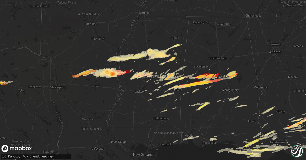
Hail Map in Mississippi on March 23, 2013
Get this storm
March 23 map
$229
one time, instant access
Download today. No call, no setup
Keep the $229
Bought the map and want the full workflow? Apply the entire $229 to a subscription within 7 days. None of it is wasted.
Every map, not just this one
This buys you this map. Subscription and you get every map we run, in the markets you choose from a few cities to whole states to nationwide. Plus real-time alerts the moment a storm fires.
Contact data
Name, contact info, occupancy, even credit band for addresses in the footprint. You go from where it hit to who to call.
Become the source they trust
Unlimited branding weather history reports on demand. You already have the documented answer ready for the property owner, and you are the one who showed up with it.
Property data and RoofTrace estimates
Pull up any address you have got, its value and the exact code rules for that jurisdiction, straight from One Click Code. Then RoofTrace estimates the squares, pitch, and roof value, priced the way you price.
Storm reports in Mississippi
Mississippi
| Date | Description |
|---|---|
| 03/23/20136:55 PM CDT | A small shed was blown into a field in the hopedale community |
| 03/23/20136:53 PM CDT | Roofs were damaged...two trees were downed...and a power line was blown onto a road |
| 03/23/20136:40 PM CDT | A local report indicates 1.00 inch wind near DAMASCUS |
| 03/23/20136:40 PM CDT | Between schlater and shellmound |
| 03/23/20136:30 PM CDT | Dime to quarter size hail covering the ground along kewanee road |
| 03/23/20136:30 PM CDT | Nickel to quarter size hail |
| 03/23/20136:18 PM CDT | A local report indicates 1.00 inch wind near 7 NW INDIANOLA |
| 03/23/20136:14 PM CDT | Quarter to half dollar size hail in the bailey community |
| 03/23/20136:14 PM CDT | Relayed via broadcast media |
| 03/23/20131:10 PM CDT | Reported along pecan grove road |
| 03/23/20133:00 AM CDT | Nickel to quarter. Report via social media |
| 03/23/20131:44 AM CDT | Observed along ms highway 541 |
| 03/22/20139:56 PM CDT | Lots of dime to nickel size hail along elm street with at least a few stones up to quarter size |
| 03/22/20139:38 PM CDT | In crossgates |
| 03/22/20138:42 PM CDT | Dime...quarter and up to golfball size. Report via social media. |
| 03/22/20138:42 PM CDT | Near the kemper/winston county line |
| 03/22/20138:38 PM CDT | Couple of trees down north of philadelphia. One is on hwy 19 and another on hwy 15 |
| 03/22/20138:36 PM CDT | Near the kemper/neshoba county line |
| 03/22/20138:33 PM CDT | A local report indicates 2.00 inch wind near STARKVILLE |
| 03/22/20138:32 PM CDT | A local report indicates 1.25 inch wind near 1 N STARKVILLE |
| 03/22/20138:31 PM CDT | A local report indicates 1.00 inch wind near 5 NE STARKVILLE |
| 03/22/20138:28 PM CDT | Quarter hail covering the ground at hwy 12 and jackson street. |
| 03/22/20138:20 PM CDT | Tree limbs down along hwy 35 in dossville. |
| 03/22/20138:20 PM CDT | Dime to quarter size hail reported |
| 03/22/20137:45 PM CDT | A local report indicates 1.00 inch wind near 2 NNE EBENEZER |
| 03/22/20137:40 PM CDT | A local report indicates 1.00 inch wind near BELLEFONTAINE |
| 03/22/20137:40 PM CDT | Report via social media |
| 03/22/20137:25 PM CDT | Hail ranging from quarter to golf ball reported in yazoo city. |
| 03/22/20137:25 PM CDT | Multiple trees downed in yazoo city |
| 03/22/20137:20 PM CDT | Hail up to quarter size covering the ground |
| 03/22/20137:12 PM CDT | A local report indicates 1.00 inch wind near 2 NNE EBENEZER |
| 03/22/20137:10 PM CDT | Reported in the city of grenada |
| 03/22/20137:10 PM CDT | Golfball size hail north of the city of grenada. |
| 03/22/20137:08 PM CDT | Power lines downed along pea ridge road |
| 03/22/20137:02 PM CDT | A few trees blown down in town |
| 03/22/20137:02 PM CDT | Roof blown off a trailer in the community of vickland |
All States Impacted by Hail Map on March 23, 2013
Cities Impacted by Hail Map on March 23, 2013
- Oak Hill, FL
- Edgewater, FL
- Lexington, MS
- Benton, MS
- Yazoo City, MS
- Pickens, MS
- Tifton, GA
- Eupora, MS
- Bellefontaine, MS
- Walthall, MS
- Meridian, MS
- Louin, MS
- Hickory, MS
- Chunky, MS
- Rose Hill, MS
- Raleigh, MS
- Enterprise, MS
- Philadelphia, MS
- Starkville, MS
- Carthage, MS
- Doddsville, MS
- Mathiston, MS
- Schlater, MS
- Woodland, MS
- Winona, MS
- Greenville, MS
- Indianola, MS
- Sunflower, MS
- Mantee, MS
- Kilmichael, MS
- Itta Bena, MS
- Leland, MS
- McGehee, AR
- McCarley, MS
- Holcomb, MS
- Grenada, MS
- Vardaman, MS
- Duck Hill, MS
- Shaw, MS
- Carrollton, MS
- Greenwood, MS
- Houston, MS
- Calhoun City, MS
- Stewart, MS
- Gore Springs, MS
- Maben, MS
- Lake Village, AR
- Coffeeville, MS
- Pheba, MS
- Arkansas City, AR
- Big Creek, MS
- Benoit, MS
- Dermott, AR
- Wills Point, TX
- Loxley, AL
- Robertsdale, AL
- Terrell, TX
- Kaufman, TX
- Waynesboro, MS
- Saint Augustine, FL
- West Point, MS
- Aberdeen, MS
- Lee, FL
- Glenwood, GA
- Youngstown, FL
- Altha, FL
- Clarksville, FL
- Fountain, FL
- Sopchoppy, FL
- Bristol, FL
- Wewahitchka, FL
- Nicholls, GA
- Alma, GA
- Live Oak, FL
- Vidalia, GA
- Milton, FL
- Linden, AL
- Gallion, AL
- Demopolis, AL
- Lisbon, LA
- Strong, AR
- El Dorado, AR
- Haynesville, LA
- Lillie, LA
- Summerfield, LA
- Huttig, AR
- Spearsville, LA
- Bernice, LA
- Homer, LA
- Junction City, AR
- Farmerville, LA
- Marion, LA
- Moultrie, GA
- Nashville, GA
- Pearson, GA
- Barney, GA
- Willacoochee, GA
- Adel, GA
- Axson, GA
- Douglas, GA
- Little Rock, MS
- Scooba, MS
- Collinsville, MS
- Porterville, MS
- Union, MS
- Emelle, AL
- De Kalb, MS
- Adrian, GA
- Kite, GA
- Marion Junction, AL
- Joshua, TX
- Forney, TX
- Crowley, TX
- Lancaster, TX
- Midlothian, TX
- Godley, TX
- Granbury, TX
- Desoto, TX
- Cresson, TX
- Grand Prairie, TX
- Crandall, TX
- Fort Worth, TX
- Red Oak, TX
- Cedar Hill, TX
- Mansfield, TX
- Balch Springs, TX
- Duncanville, TX
- Burleson, TX
- Alvarado, TX
- Lillian, TX
- Venus, TX
- Dallas, TX
- Hutchins, TX
- Wilmer, TX
- Scurry, TX
- Seagoville, TX
- Sturgis, MS
- Shuqualak, MS
- Louisville, MS
- Preston, MS
- Lawtey, FL
- Greenville, FL
- Lenox, GA
- Sallis, MS
- Wellborn, FL
- Lake City, FL
- Clanton, AL
- Troy, AL
- Glen Allan, MS
- Hamburg, AR
- Bastrop, LA
- Mer Rouge, LA
- Crossett, AR
- Mayersville, MS
- Oak Grove, LA
- Eudora, AR
- Bonita, LA
- Parkdale, AR
- Jones, LA
- Lake Providence, LA
- Wilmot, AR
- Goodman, MS
- Lake Butler, FL
- Valdosta, GA
- Quitman, GA
- Greensboro, AL
- White Oak, GA
- Woodbine, GA
- Climax, GA
- Ellisville, MS
- Akron, AL
- Moundville, AL
- Green Cove Springs, FL
- Silver City, MS
- West Blocton, AL
- Defuniak Springs, FL
- Hilliard, FL
- Brundidge, AL
- Banks, AL
- Goshen, AL
- Louisville, AL
- Vaughan, MS
- Camden, MS
- Kosciusko, MS
- Durant, MS
- Mims, FL
- Starke, FL
- Raiford, FL
- Forest, MS
- Bailey, MS
- Centreville, AL
- Lawley, AL
- Panama City, FL
- Elkton, FL
- Blackshear, GA
- Waycross, GA
- Forkland, AL
- Newbern, AL
- Ambrose, GA
- Lyons, GA
- Reidsville, GA
- Ovett, MS
- Moselle, MS
- Laurel, MS
- Okolona, MS
- Nettleton, MS
- Glennville, GA
- Fort Stewart, GA
- Claxton, GA
- Columbus, MS
- Crawford, MS
- Jacksonville, FL
- Toomsuba, MS
- Livingston, AL
- Marion, AL
- Uniontown, AL
- Lauderdale, MS
- York, AL
- Cuba, AL
- Ackerman, MS
- Weir, MS
- Naylor, GA
- Stockton, GA
- Du Pont, GA
- Fargo, GA
- Carrollton, AL
- Aliceville, AL
- Grady, AL
- Mathews, AL
- Ramer, AL
- Plantersville, AL
- Marion, MS
- Stanton, AL
- Maplesville, AL
- Perry, FL
- Canton, MS
- Equality, AL
- Sylacauga, AL
- Rockford, AL
- Goodwater, AL
- Kellyton, AL
- Weogufka, AL
- Alexander City, AL
- Rolling Fork, MS
- Ferris, TX
- Hahira, GA
- Lakeland, GA
- Berlin, GA
- Pavo, GA
- Coolidge, GA
- Sparks, GA
- Thomasville, GA
- Mershon, GA
- Lena, MS
- Crawfordville, FL
- Tallahassee, FL
- Havana, FL
- Twin City, GA
- Swainsboro, GA
- Soperton, GA
- Camden, AL
- Vredenburgh, AL
- Lower Peach Tree, AL
- Ocilla, GA
- Wray, GA
- Alapaha, GA
- Cleburne, TX
- Lamont, FL
- Middleburg, FL
- Norman Park, GA
- Omega, GA
- Hosford, FL
- Marianna, FL
- Sneads, FL
- Grand Ridge, FL
- Monticello, FL
- Cedarbluff, MS
- Mississippi State, MS
- McCool, MS
- Faunsdale, AL
- Dawson, GA
- Edison, GA
- Shellman, GA
- Morgan, GA
- Cuthbert, GA
- Shorterville, AL
- Abbeville, AL
- Columbia, AL
- Uvalda, GA
- Highland Home, AL
- Lapine, AL
- Selma, AL
- Morton, MS
- Fernandina Beach, FL
- Yulee, FL
- Brent, AL
- Sawyerville, AL
- Pelahatchie, MS
- Brandon, MS
- Palm Coast, FL
- Noxapater, MS
- Port Saint Joe, FL
- Macon, MS
- Horseshoe Beach, FL
- Old Town, FL
- Mendenhall, MS
- Glen Saint Mary, FL
- Orange Park, FL
- Saint Johns, FL
- Sanderson, FL
- Keystone Heights, FL
- Hastings, FL
- McAlpin, FL
- Madison, FL
- Fleming Island, FL
- Palatka, FL
- Mayo, FL
- White Springs, FL
- East Palatka, FL
- Thorsby, AL
- Blakely, GA
- Bluffton, GA
- Fort Gaines, GA
- Whatley, AL
- Coy, AL
- Grove Hill, AL
- Cadwell, GA
- McRae Helena, GA
- Alamo, GA
- Quincy, FL
- Blountstown, FL
- Chattahoochee, FL
- Chipley, FL
- Conehatta, MS
- Arlington, TX
- Newton, MS
- Louise, MS
- Dixie, GA
- Boston, GA
- Saint Marks, FL
- Eastpoint, FL
- Ponte Vedra Beach, FL
- Randolph, AL
- Coffeeville, AL
- Fort White, FL
- Sardis, GA
- Mount Vernon, GA
- Ailey, GA
- Savannah, GA
- Mobile, AL
- Theodore, AL
- Fort Deposit, AL
- Attapulgus, GA
- Bainbridge, GA
- Sylvania, GA
- Navarre, FL
- Thomasville, AL
- Pine Mountain Valley, GA
- Hamilton, GA
- Pine Mountain, GA
- Ray City, GA
- Ochlocknee, GA
- Morven, GA
- Walnut Grove, MS
- Hollandale, MS
- Anguilla, MS
- Chatham, MS
- Portland, AR
- Tarrytown, GA
- Greenville, AL
- Lake, MS
- Eutaw, AL
- Decatur, MS
- Boligee, AL
- Letohatchee, AL
- Hope Hull, AL
- Hampton, FL
- Ruleville, MS
- Boyle, MS
- Moorhead, MS
- Amory, MS
- Rohwer, AR
- Richmond Hill, GA
- Grand Saline, TX
- Epes, AL
- Verbena, AL
- Jemison, AL
- Gainesville, AL
- Minter, AL
- Forest Home, AL
- Prairie, MS
- Lulu, FL
- Cairo, GA
- Gretna, FL
- Panama City Beach, FL
- Whigham, GA
- Lynn Haven, FL
- Irvington, AL
- Grand Bay, AL
- Fitzpatrick, AL
- Daphne, AL
- Fairhope, AL
- Lisman, AL
- Jachin, AL
- Pennington, AL
- Ward, AL
- Headland, AL
- Leary, GA
- Arlington, GA
- Donalsonville, GA
- French Camp, MS
- Millen, GA
- Florahome, FL
- Tchula, MS
- Colquitt, GA
- Iron City, GA
- Brooksville, MS
- Vancleave, MS
- Gautier, MS
- Ocean Springs, MS
- Knoxville, AL
- Millwood, GA
- Chauncey, GA
- Eastman, GA
- Edgewood, TX
- Quitman, MS
- Pensacola, FL
- Waverly, GA
- Fruitvale, TX
- Canton, TX
- Mingus, TX
- Lipan, TX
- Gordon, TX
- Bluff Dale, TX
- Tolar, TX
- Stephenville, TX
- Ranger, TX
- Buffalo Gap, TX
- Tuscola, TX
- Merkel, TX
- Nolan, TX
- Abilene, TX
- Ovalo, TX
- Wingate, TX
- Loraine, TX
- Colorado City, TX
- Westbrook, TX
- Chiefland, FL


