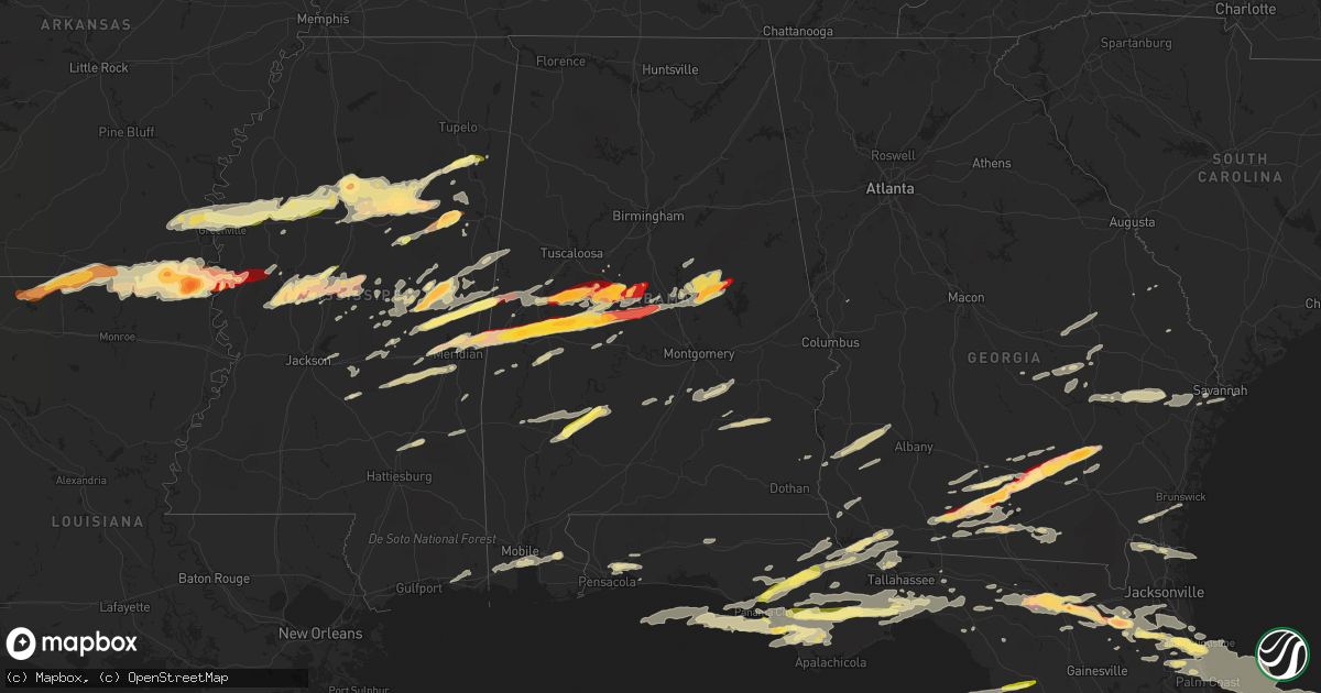
Hail Map in Alabama on March 23, 2013
Get this storm
March 23 map
$229
one time, instant access
Download today. No call, no setup
Keep the $229
Bought the map and want the full workflow? Apply the entire $229 to a subscription within 7 days. None of it is wasted.
Every map, not just this one
This buys you this map. Subscription and you get every map we run, in the markets you choose from a few cities to whole states to nationwide. Plus real-time alerts the moment a storm fires.
Contact data
Name, contact info, occupancy, even credit band for addresses in the footprint. You go from where it hit to who to call.
Become the source they trust
Unlimited branding weather history reports on demand. You already have the documented answer ready for the property owner, and you are the one who showed up with it.
Property data and RoofTrace estimates
Pull up any address you have got, its value and the exact code rules for that jurisdiction, straight from One Click Code. Then RoofTrace estimates the squares, pitch, and roof value, priced the way you price.
Storm reports in Alabama
Alabama
| Date | Description |
|---|---|
| 03/23/201312:15 AM CDT | A local report indicates 1.00 inch wind near 3 NNW CLEVELAND CROSSRO |
| 03/22/201311:57 PM CDT | Trees and power lines reported down throughout the city of goodwater. |
| 03/22/201311:42 PM CDT | A large tree fell and caused a auto accident. Fire crews were removing trapped people in the vehicle. |
| 03/22/201311:38 PM CDT | Trees down at kellys crossroads and alabama highway 22. |
| 03/22/201311:32 PM CDT | Damage reported to campers and vehicles from falling trees at higgins ferry park on lake mitchell. Reported from social media. Time estimated from radar. |
| 03/22/201311:30 PM CDT | Portions of a roof were torn off along with siding of a home near cargle creek on lake mitchell. Reported by social media. Time estimated from radar. |
| 03/22/201311:21 PM CDT | Quarter size hail reported along interstate 65 just north of exit 208 near clanton. |
| 03/22/201311:06 PM CDT | A home was damaged along county road 706. |
| 03/22/201311:01 PM CDT | A few trees down 1 mile east of randolph along county road 36. |
| 03/22/201310:54 PM CDT | Along highway 280 near the coosa and tallapoosa county line. Time corrected from radar and location corrected. |
| 03/22/201310:51 PM CDT | Along highway 280 near coosa and tallapoosa county line. |
| 03/22/201310:47 PM CDT | Sheriff reporting trees down near valley street and highway 219 south |
| 03/22/201310:46 PM CDT | A local report indicates 1.75 inch wind near ROCKFORD |
| 03/22/201310:45 PM CDT | Covering the road. |
| 03/22/201310:42 PM CDT | In brent and in pondville |
| 03/22/201310:22 PM CDT | A local report indicates 1.75 inch wind near HAVANA |
| 03/22/201310:04 PM CDT | Tree down on a house on vera vista avenue in eutaw. |
| 03/22/201310:04 PM CDT | Trees reported down throughout the city of eutaw...including one tree down on a vehicle. |
| 03/22/20138:38 PM CDT | Along highway 43. |
| 03/22/20138:35 PM CDT | Along highway 43. |
| 03/22/20138:30 PM CDT | Quarter size hail reported near the amerifoods gas station on u.s. Highway 231. |
| 03/22/20138:15 PM CDT | A local report indicates 1.00 inch wind near MAPLESVILLE |
| 03/22/20137:47 PM CDT | Near judson college. Several window panes and windows broken. |
| 03/22/20137:34 PM CDT | Golf ball hail broke out windows and damaged homes near newburn. |
| 03/22/20137:23 PM CDT | The golf ball size hail is now completely covering the ground. |
| 03/22/20137:18 PM CDT | Estimated hail the size of ping pong balls near the greene county steam plant on the black warrior river. Reported by social media. Time estimated from radar. |
| 03/22/20137:16 PM CDT | Hail at least one half inch deep. |
| 03/22/20137:13 PM CDT | Power pole and power lines blown down on highway 43 at the national guard armory. |
| 03/22/20137:01 PM CDT | Golf ball hail covering the ground at the bp food mart on highway 28. |
All States Impacted by Hail Map on March 23, 2013
Cities Impacted by Hail Map on March 23, 2013
- Oak Hill, FL
- Edgewater, FL
- Lexington, MS
- Benton, MS
- Yazoo City, MS
- Pickens, MS
- Tifton, GA
- Eupora, MS
- Bellefontaine, MS
- Walthall, MS
- Meridian, MS
- Louin, MS
- Hickory, MS
- Chunky, MS
- Rose Hill, MS
- Raleigh, MS
- Enterprise, MS
- Philadelphia, MS
- Starkville, MS
- Carthage, MS
- Doddsville, MS
- Mathiston, MS
- Schlater, MS
- Woodland, MS
- Winona, MS
- Greenville, MS
- Indianola, MS
- Sunflower, MS
- Mantee, MS
- Kilmichael, MS
- Itta Bena, MS
- Leland, MS
- McGehee, AR
- McCarley, MS
- Holcomb, MS
- Grenada, MS
- Vardaman, MS
- Duck Hill, MS
- Shaw, MS
- Carrollton, MS
- Greenwood, MS
- Houston, MS
- Calhoun City, MS
- Stewart, MS
- Gore Springs, MS
- Maben, MS
- Lake Village, AR
- Coffeeville, MS
- Pheba, MS
- Arkansas City, AR
- Big Creek, MS
- Benoit, MS
- Dermott, AR
- Wills Point, TX
- Loxley, AL
- Robertsdale, AL
- Terrell, TX
- Kaufman, TX
- Waynesboro, MS
- Saint Augustine, FL
- West Point, MS
- Aberdeen, MS
- Lee, FL
- Glenwood, GA
- Youngstown, FL
- Altha, FL
- Clarksville, FL
- Fountain, FL
- Sopchoppy, FL
- Bristol, FL
- Wewahitchka, FL
- Nicholls, GA
- Alma, GA
- Live Oak, FL
- Vidalia, GA
- Milton, FL
- Linden, AL
- Gallion, AL
- Demopolis, AL
- Lisbon, LA
- Strong, AR
- El Dorado, AR
- Haynesville, LA
- Lillie, LA
- Summerfield, LA
- Huttig, AR
- Spearsville, LA
- Bernice, LA
- Homer, LA
- Junction City, AR
- Farmerville, LA
- Marion, LA
- Moultrie, GA
- Nashville, GA
- Pearson, GA
- Barney, GA
- Willacoochee, GA
- Adel, GA
- Axson, GA
- Douglas, GA
- Little Rock, MS
- Scooba, MS
- Collinsville, MS
- Porterville, MS
- Union, MS
- Emelle, AL
- De Kalb, MS
- Adrian, GA
- Kite, GA
- Marion Junction, AL
- Joshua, TX
- Forney, TX
- Crowley, TX
- Lancaster, TX
- Midlothian, TX
- Godley, TX
- Granbury, TX
- Desoto, TX
- Cresson, TX
- Grand Prairie, TX
- Crandall, TX
- Fort Worth, TX
- Red Oak, TX
- Cedar Hill, TX
- Mansfield, TX
- Balch Springs, TX
- Duncanville, TX
- Burleson, TX
- Alvarado, TX
- Lillian, TX
- Venus, TX
- Dallas, TX
- Hutchins, TX
- Wilmer, TX
- Scurry, TX
- Seagoville, TX
- Sturgis, MS
- Shuqualak, MS
- Louisville, MS
- Preston, MS
- Lawtey, FL
- Greenville, FL
- Lenox, GA
- Sallis, MS
- Wellborn, FL
- Lake City, FL
- Clanton, AL
- Troy, AL
- Glen Allan, MS
- Hamburg, AR
- Bastrop, LA
- Mer Rouge, LA
- Crossett, AR
- Mayersville, MS
- Oak Grove, LA
- Eudora, AR
- Bonita, LA
- Parkdale, AR
- Jones, LA
- Lake Providence, LA
- Wilmot, AR
- Goodman, MS
- Lake Butler, FL
- Valdosta, GA
- Quitman, GA
- Greensboro, AL
- White Oak, GA
- Woodbine, GA
- Climax, GA
- Ellisville, MS
- Akron, AL
- Moundville, AL
- Green Cove Springs, FL
- Silver City, MS
- West Blocton, AL
- Defuniak Springs, FL
- Hilliard, FL
- Brundidge, AL
- Banks, AL
- Goshen, AL
- Louisville, AL
- Vaughan, MS
- Camden, MS
- Kosciusko, MS
- Durant, MS
- Mims, FL
- Starke, FL
- Raiford, FL
- Forest, MS
- Bailey, MS
- Centreville, AL
- Lawley, AL
- Panama City, FL
- Elkton, FL
- Blackshear, GA
- Waycross, GA
- Forkland, AL
- Newbern, AL
- Ambrose, GA
- Lyons, GA
- Reidsville, GA
- Ovett, MS
- Moselle, MS
- Laurel, MS
- Okolona, MS
- Nettleton, MS
- Glennville, GA
- Fort Stewart, GA
- Claxton, GA
- Columbus, MS
- Crawford, MS
- Jacksonville, FL
- Toomsuba, MS
- Livingston, AL
- Marion, AL
- Uniontown, AL
- Lauderdale, MS
- York, AL
- Cuba, AL
- Ackerman, MS
- Weir, MS
- Naylor, GA
- Stockton, GA
- Du Pont, GA
- Fargo, GA
- Carrollton, AL
- Aliceville, AL
- Grady, AL
- Mathews, AL
- Ramer, AL
- Plantersville, AL
- Marion, MS
- Stanton, AL
- Maplesville, AL
- Perry, FL
- Canton, MS
- Equality, AL
- Sylacauga, AL
- Rockford, AL
- Goodwater, AL
- Kellyton, AL
- Weogufka, AL
- Alexander City, AL
- Rolling Fork, MS
- Ferris, TX
- Hahira, GA
- Lakeland, GA
- Berlin, GA
- Pavo, GA
- Coolidge, GA
- Sparks, GA
- Thomasville, GA
- Mershon, GA
- Lena, MS
- Crawfordville, FL
- Tallahassee, FL
- Havana, FL
- Twin City, GA
- Swainsboro, GA
- Soperton, GA
- Camden, AL
- Vredenburgh, AL
- Lower Peach Tree, AL
- Ocilla, GA
- Wray, GA
- Alapaha, GA
- Cleburne, TX
- Lamont, FL
- Middleburg, FL
- Norman Park, GA
- Omega, GA
- Hosford, FL
- Marianna, FL
- Sneads, FL
- Grand Ridge, FL
- Monticello, FL
- Cedarbluff, MS
- Mississippi State, MS
- McCool, MS
- Faunsdale, AL
- Dawson, GA
- Edison, GA
- Shellman, GA
- Morgan, GA
- Cuthbert, GA
- Shorterville, AL
- Abbeville, AL
- Columbia, AL
- Uvalda, GA
- Highland Home, AL
- Lapine, AL
- Selma, AL
- Morton, MS
- Fernandina Beach, FL
- Yulee, FL
- Brent, AL
- Sawyerville, AL
- Pelahatchie, MS
- Brandon, MS
- Palm Coast, FL
- Noxapater, MS
- Port Saint Joe, FL
- Macon, MS
- Horseshoe Beach, FL
- Old Town, FL
- Mendenhall, MS
- Glen Saint Mary, FL
- Orange Park, FL
- Saint Johns, FL
- Sanderson, FL
- Keystone Heights, FL
- Hastings, FL
- McAlpin, FL
- Madison, FL
- Fleming Island, FL
- Palatka, FL
- Mayo, FL
- White Springs, FL
- East Palatka, FL
- Thorsby, AL
- Blakely, GA
- Bluffton, GA
- Fort Gaines, GA
- Whatley, AL
- Coy, AL
- Grove Hill, AL
- Cadwell, GA
- McRae Helena, GA
- Alamo, GA
- Quincy, FL
- Blountstown, FL
- Chattahoochee, FL
- Chipley, FL
- Conehatta, MS
- Arlington, TX
- Newton, MS
- Louise, MS
- Dixie, GA
- Boston, GA
- Saint Marks, FL
- Eastpoint, FL
- Ponte Vedra Beach, FL
- Randolph, AL
- Coffeeville, AL
- Fort White, FL
- Sardis, GA
- Mount Vernon, GA
- Ailey, GA
- Savannah, GA
- Mobile, AL
- Theodore, AL
- Fort Deposit, AL
- Attapulgus, GA
- Bainbridge, GA
- Sylvania, GA
- Navarre, FL
- Thomasville, AL
- Pine Mountain Valley, GA
- Hamilton, GA
- Pine Mountain, GA
- Ray City, GA
- Ochlocknee, GA
- Morven, GA
- Walnut Grove, MS
- Hollandale, MS
- Anguilla, MS
- Chatham, MS
- Portland, AR
- Tarrytown, GA
- Greenville, AL
- Lake, MS
- Eutaw, AL
- Decatur, MS
- Boligee, AL
- Letohatchee, AL
- Hope Hull, AL
- Hampton, FL
- Ruleville, MS
- Boyle, MS
- Moorhead, MS
- Amory, MS
- Rohwer, AR
- Richmond Hill, GA
- Grand Saline, TX
- Epes, AL
- Verbena, AL
- Jemison, AL
- Gainesville, AL
- Minter, AL
- Forest Home, AL
- Prairie, MS
- Lulu, FL
- Cairo, GA
- Gretna, FL
- Panama City Beach, FL
- Whigham, GA
- Lynn Haven, FL
- Irvington, AL
- Grand Bay, AL
- Fitzpatrick, AL
- Daphne, AL
- Fairhope, AL
- Lisman, AL
- Jachin, AL
- Pennington, AL
- Ward, AL
- Headland, AL
- Leary, GA
- Arlington, GA
- Donalsonville, GA
- French Camp, MS
- Millen, GA
- Florahome, FL
- Tchula, MS
- Colquitt, GA
- Iron City, GA
- Brooksville, MS
- Vancleave, MS
- Gautier, MS
- Ocean Springs, MS
- Knoxville, AL
- Millwood, GA
- Chauncey, GA
- Eastman, GA
- Edgewood, TX
- Quitman, MS
- Pensacola, FL
- Waverly, GA
- Fruitvale, TX
- Canton, TX
- Mingus, TX
- Lipan, TX
- Gordon, TX
- Bluff Dale, TX
- Tolar, TX
- Stephenville, TX
- Ranger, TX
- Buffalo Gap, TX
- Tuscola, TX
- Merkel, TX
- Nolan, TX
- Abilene, TX
- Ovalo, TX
- Wingate, TX
- Loraine, TX
- Colorado City, TX
- Westbrook, TX
- Chiefland, FL


