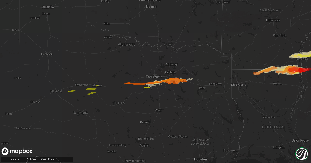
Hail Map on March 23, 2013
Get this storm
March 23 map
$229
one time, instant access
Download today. No call, no setup
Keep the $229
Bought the map and want the full workflow? Apply the entire $229 to a subscription within 7 days. None of it is wasted.
Every map, not just this one
This buys you this map. Subscription and you get every map we run, in the markets you choose from a few cities to whole states to nationwide. Plus real-time alerts the moment a storm fires.
Contact data
Name, contact info, occupancy, even credit band for addresses in the footprint. You go from where it hit to who to call.
Become the source they trust
Unlimited branding weather history reports on demand. You already have the documented answer ready for the property owner, and you are the one who showed up with it.
Property data and RoofTrace estimates
Pull up any address you have got, its value and the exact code rules for that jurisdiction, straight from One Click Code. Then RoofTrace estimates the squares, pitch, and roof value, priced the way you price.
Storm reports
Louisiana
| Date | Description |
|---|---|
| 03/23/20136:45 PM CDT | Trees downed and a barn was damaged in lake providence |
| 03/23/20136:35 PM CDT | A few trees were downed across northern west carroll parish |
| 03/23/20136:35 PM CDT | Wind-blown hail damaged the door of a house in kilbourne |
| 03/23/20136:34 PM CDT | In the terry community |
| 03/23/20136:33 PM CDT | Hail up to baseball size broke windows...left holes in mobile homes...damaged vehicles...and knocked down several limbs. |
| 03/23/20136:32 PM CDT | Part of the roof of a mobile home was blown off |
| 03/23/20136:30 PM CDT | Windows broken out and siding damaged by hail up to ping pong size hail near the concord community |
| 03/23/20136:15 PM CDT | Accumulations of hail up to quarter size between bonita and beekman |
| 03/23/20136:05 PM CDT | Dime to quarter size hail accumulating on the ground from beekman north to the arkansas border |
| 03/23/20136:05 PM CDT | Trees blown down between beekman and bonita. Sheds also blown down. |
| 03/23/20135:40 PM CDT | Trees down on highway 15 northwest of farmerville |
| 03/22/20139:56 PM CDT | Lots of dime to nickel size hail along elm street with at least a few stones up to quarter size |
Arkansas
| Date | Description |
|---|---|
| 03/23/20136:25 PM CDT | A local report indicates 1.75 inch wind near WILMOT |
| 03/23/20135:40 PM CDT | A local report indicates 1.25 inch wind near 3 E DERMOTT |
Mississippi
| Date | Description |
|---|---|
| 03/23/20136:55 PM CDT | A small shed was blown into a field in the hopedale community |
| 03/23/20136:53 PM CDT | Roofs were damaged...two trees were downed...and a power line was blown onto a road |
| 03/23/20136:40 PM CDT | A local report indicates 1.00 inch wind near DAMASCUS |
| 03/23/20136:40 PM CDT | Between schlater and shellmound |
| 03/23/20136:30 PM CDT | Nickel to quarter size hail |
| 03/23/20136:30 PM CDT | Dime to quarter size hail covering the ground along kewanee road |
| 03/23/20136:18 PM CDT | A local report indicates 1.00 inch wind near 7 NW INDIANOLA |
| 03/23/20136:14 PM CDT | Relayed via broadcast media |
| 03/23/20136:14 PM CDT | Quarter to half dollar size hail in the bailey community |
| 03/23/20131:10 PM CDT | Reported along pecan grove road |
| 03/23/20133:00 AM CDT | Nickel to quarter. Report via social media |
| 03/23/20131:44 AM CDT | Observed along ms highway 541 |
| 03/22/20139:56 PM CDT | Lots of dime to nickel size hail along elm street with at least a few stones up to quarter size |
| 03/22/20139:38 PM CDT | In crossgates |
| 03/22/20138:42 PM CDT | Dime...quarter and up to golfball size. Report via social media. |
| 03/22/20138:42 PM CDT | Near the kemper/winston county line |
| 03/22/20138:38 PM CDT | Couple of trees down north of philadelphia. One is on hwy 19 and another on hwy 15 |
| 03/22/20138:36 PM CDT | Near the kemper/neshoba county line |
| 03/22/20138:33 PM CDT | A local report indicates 2.00 inch wind near STARKVILLE |
| 03/22/20138:32 PM CDT | A local report indicates 1.25 inch wind near 1 N STARKVILLE |
| 03/22/20138:31 PM CDT | A local report indicates 1.00 inch wind near 5 NE STARKVILLE |
| 03/22/20138:28 PM CDT | Quarter hail covering the ground at hwy 12 and jackson street. |
| 03/22/20138:20 PM CDT | Tree limbs down along hwy 35 in dossville. |
| 03/22/20138:20 PM CDT | Dime to quarter size hail reported |
| 03/22/20137:45 PM CDT | A local report indicates 1.00 inch wind near 2 NNE EBENEZER |
| 03/22/20137:40 PM CDT | Report via social media |
| 03/22/20137:40 PM CDT | A local report indicates 1.00 inch wind near BELLEFONTAINE |
| 03/22/20137:25 PM CDT | Multiple trees downed in yazoo city |
| 03/22/20137:25 PM CDT | Hail ranging from quarter to golf ball reported in yazoo city. |
| 03/22/20137:20 PM CDT | Hail up to quarter size covering the ground |
| 03/22/20137:12 PM CDT | A local report indicates 1.00 inch wind near 2 NNE EBENEZER |
| 03/22/20137:10 PM CDT | Golfball size hail north of the city of grenada. |
| 03/22/20137:10 PM CDT | Reported in the city of grenada |
| 03/22/20137:08 PM CDT | Power lines downed along pea ridge road |
| 03/22/20137:02 PM CDT | A few trees blown down in town |
| 03/22/20137:02 PM CDT | Roof blown off a trailer in the community of vickland |
Texas
| Date | Description |
|---|---|
| 03/23/20138:15 AM CDT | A local report indicates 1.00 inch wind near SEAGOVILLE |
| 03/23/20138:03 AM CDT | A local report indicates 1.00 inch wind near DESOTO |
| 03/23/20138:02 AM CDT | A local report indicates 1.00 inch wind near RED OAK |
| 03/23/20137:48 AM CDT | A local report indicates 1.25 inch wind near MANSFIELD |
Florida
| Date | Description |
|---|---|
| 03/23/20132:53 PM CDT | Severe strength winds produced damaged along federal point. Two homes had minor structural damage and numerous trees were blown down. Out buildings were damaged and pow |
| 03/23/20132:51 PM CDT | Severe thunderstorm winds damaged 8 homes near the west river road and mink road intersection. Homes had roof damage...numerous trees down...and out buildings damaged. |
| 03/23/20132:02 PM CDT | A local meterologist reported quarter sized hail off exit 318 heading towards the beach. |
| 03/23/20131:50 PM CDT | The public reported half dollar sized hail. |
| 03/23/20131:15 PM CDT | Quarter size hail reported at 241 churchill drive |
| 03/23/20131:00 PM CDT | Quarter size hail near camp blanding was observed. |
| 03/23/201312:55 PM CDT | The emergency manager reported that a barn was damaged and partially collapsed by high winds as well as vehicle damage. Reports of a funnel cloud at the time. The time |
| 03/23/201312:50 PM CDT | The emergency manager received reports of baseball sized hail 3 miles west of lawtey near state road 225. The time given was based on radar. |
| 03/23/201312:50 PM CDT | The emergency management reported a tree and powerlines blocking the roadway on county road 125 at northwest 63 avenue. The time given was based on radar. |
| 03/23/201312:40 PM CDT | The emergency manager reported trees blown down which blocked the roadways near 121 west and state road 16. The time given was based on radar. |
| 03/23/201312:11 PM CDT | Wruftv reported golf ball sized hail in lake city. |
| 03/23/201312:08 PM CDT | Broadcast media relayed reports of trees down along se margaret drive in lake city. Time is estimated from radar. |
| 03/23/201311:50 AM CDT | The emergency manager received reports of golf ball sized hail at wellborn. |
| 03/23/20139:54 AM CDT | Slightly larger than quarter size hail reported by motorist. |
| 03/23/20139:00 AM CDT | Via wctv social media. |
| 03/23/20138:47 AM CDT | Quarter size hail 5 ssw of crawfordville. |
| 03/23/20137:52 AM CDT | Via wjhg social media. |
| 03/23/20137:47 AM CDT | Via wjhg social media. |
| 03/23/20137:45 AM CDT | Quarter inch hail in wewahitchka. |
| 03/23/20137:41 AM CDT | Via wjhg social media. |
| 03/23/20137:41 AM CDT | Via wjhg social media. |
| 03/23/20137:29 AM CDT | Via wjhg social media. |
| 03/23/20137:15 AM CDT | Via wmbb social media. |
| 03/23/20136:50 AM CDT | Pine tree blown onto truck. |
| 03/23/20136:50 AM CDT | Trees blocking eastbound lanes of i10 at mile marker 199. Time estimated from radar. |
| 03/23/20136:20 AM CDT | Tree blocking bloxham cutoff. Time estimated by radar. |
Georgia
| Date | Description |
|---|---|
| 03/23/201311:10 AM CDT | Walb-tv relayed a public report via facebook of golfball sized hail in alma. |
| 03/23/201310:45 AM CDT | Emergency manager reported golf ball sized hail south-southeast of douglas. |
| 03/23/201310:42 AM CDT | Photo confirmation. |
| 03/23/201310:30 AM CDT | Emergency manager reported golf ball sized hail in willacoochee. |
| 03/23/201310:17 AM CDT | Public report of pine trees down on n old coffee road...via walb news 10 facebook page |
| 03/23/201310:15 AM CDT | Multiple trees and powerlines down within nashville city limits. Several hail reports as well. |
| 03/23/201310:13 AM CDT | Golfball size hail. Photo confirmation. |
| 03/23/201310:12 AM CDT | Public report of golf ball size hail on highway 76 about 3 miles west of nashville...via walb news 10 facebook page |
| 03/23/201310:05 AM CDT | Quarter size hail on hwy 37 in western berrien county. |
| 03/23/201310:03 AM CDT | Public report of golf ball size hail in adel...via walb news 10 facebook page |
| 03/23/201310:00 AM CDT | Quarter size hail on hwy 37 in western berrien county. |
| 03/23/20139:58 AM CDT | Hail covered the ground. |
| 03/23/20139:30 AM CDT | Quarter size hail 1 mile south of coolidge. |
| 03/23/20136:50 AM CDT | The banks county emergency manager reported that an old chicken house and a barn sustained minor damage from strong winds along carson segars road. Several trees were b |
| 03/23/20136:18 AM CDT | The public reported large hail and a couple of trees down on the north side of vidalia. |
| 03/23/20136:10 AM CDT | Multiple trees down in grady county. |
| 03/23/20136:10 AM CDT | The public reported hail up to the size of quarters. |
| 03/23/20135:57 AM CDT | A few trees were blown down on the golf course. |
| 03/23/20135:50 AM CDT | A tree was blown down along durham street in chauncey. |
| 03/23/20133:10 AM CDT | Parishioners at a local church and an employee at the flat creek lodge reported trees down on the east side of summertown. |
Alabama
| Date | Description |
|---|---|
| 03/23/201312:15 AM CDT | A local report indicates 1.00 inch wind near 3 NNW CLEVELAND CROSSRO |
| 03/22/201311:57 PM CDT | Trees and power lines reported down throughout the city of goodwater. |
| 03/22/201311:42 PM CDT | A large tree fell and caused a auto accident. Fire crews were removing trapped people in the vehicle. |
| 03/22/201311:38 PM CDT | Trees down at kellys crossroads and alabama highway 22. |
| 03/22/201311:32 PM CDT | Damage reported to campers and vehicles from falling trees at higgins ferry park on lake mitchell. Reported from social media. Time estimated from radar. |
| 03/22/201311:30 PM CDT | Portions of a roof were torn off along with siding of a home near cargle creek on lake mitchell. Reported by social media. Time estimated from radar. |
| 03/22/201311:21 PM CDT | Quarter size hail reported along interstate 65 just north of exit 208 near clanton. |
| 03/22/201311:06 PM CDT | A home was damaged along county road 706. |
| 03/22/201311:01 PM CDT | A few trees down 1 mile east of randolph along county road 36. |
| 03/22/201310:54 PM CDT | Along highway 280 near the coosa and tallapoosa county line. Time corrected from radar and location corrected. |
| 03/22/201310:51 PM CDT | Along highway 280 near coosa and tallapoosa county line. |
| 03/22/201310:47 PM CDT | Sheriff reporting trees down near valley street and highway 219 south |
| 03/22/201310:46 PM CDT | A local report indicates 1.75 inch wind near ROCKFORD |
| 03/22/201310:45 PM CDT | Covering the road. |
| 03/22/201310:42 PM CDT | In brent and in pondville |
| 03/22/201310:22 PM CDT | A local report indicates 1.75 inch wind near HAVANA |
| 03/22/201310:04 PM CDT | Trees reported down throughout the city of eutaw...including one tree down on a vehicle. |
| 03/22/201310:04 PM CDT | Tree down on a house on vera vista avenue in eutaw. |
| 03/22/20138:38 PM CDT | Along highway 43. |
| 03/22/20138:35 PM CDT | Along highway 43. |
| 03/22/20138:30 PM CDT | Quarter size hail reported near the amerifoods gas station on u.s. Highway 231. |
| 03/22/20138:15 PM CDT | A local report indicates 1.00 inch wind near MAPLESVILLE |
| 03/22/20137:47 PM CDT | Near judson college. Several window panes and windows broken. |
| 03/22/20137:34 PM CDT | Golf ball hail broke out windows and damaged homes near newburn. |
| 03/22/20137:23 PM CDT | The golf ball size hail is now completely covering the ground. |
| 03/22/20137:18 PM CDT | Estimated hail the size of ping pong balls near the greene county steam plant on the black warrior river. Reported by social media. Time estimated from radar. |
| 03/22/20137:16 PM CDT | Hail at least one half inch deep. |
| 03/22/20137:13 PM CDT | Power pole and power lines blown down on highway 43 at the national guard armory. |
| 03/22/20137:01 PM CDT | Golf ball hail covering the ground at the bp food mart on highway 28. |
Cities Impacted by Hail Map on March 23, 2013
- Oak Hill, FL
- Edgewater, FL
- Lexington, MS
- Benton, MS
- Yazoo City, MS
- Pickens, MS
- Tifton, GA
- Eupora, MS
- Bellefontaine, MS
- Walthall, MS
- Meridian, MS
- Louin, MS
- Hickory, MS
- Chunky, MS
- Rose Hill, MS
- Raleigh, MS
- Enterprise, MS
- Philadelphia, MS
- Starkville, MS
- Carthage, MS
- Doddsville, MS
- Mathiston, MS
- Schlater, MS
- Woodland, MS
- Winona, MS
- Greenville, MS
- Indianola, MS
- Sunflower, MS
- Mantee, MS
- Kilmichael, MS
- Itta Bena, MS
- Leland, MS
- McGehee, AR
- McCarley, MS
- Holcomb, MS
- Grenada, MS
- Vardaman, MS
- Duck Hill, MS
- Shaw, MS
- Carrollton, MS
- Greenwood, MS
- Houston, MS
- Calhoun City, MS
- Stewart, MS
- Gore Springs, MS
- Maben, MS
- Lake Village, AR
- Coffeeville, MS
- Pheba, MS
- Arkansas City, AR
- Big Creek, MS
- Benoit, MS
- Dermott, AR
- Wills Point, TX
- Loxley, AL
- Robertsdale, AL
- Terrell, TX
- Kaufman, TX
- Waynesboro, MS
- Saint Augustine, FL
- West Point, MS
- Aberdeen, MS
- Lee, FL
- Glenwood, GA
- Youngstown, FL
- Altha, FL
- Clarksville, FL
- Fountain, FL
- Sopchoppy, FL
- Bristol, FL
- Wewahitchka, FL
- Nicholls, GA
- Alma, GA
- Live Oak, FL
- Vidalia, GA
- Milton, FL
- Linden, AL
- Gallion, AL
- Demopolis, AL
- Lisbon, LA
- Strong, AR
- El Dorado, AR
- Haynesville, LA
- Lillie, LA
- Summerfield, LA
- Huttig, AR
- Spearsville, LA
- Bernice, LA
- Homer, LA
- Junction City, AR
- Farmerville, LA
- Marion, LA
- Moultrie, GA
- Nashville, GA
- Pearson, GA
- Barney, GA
- Willacoochee, GA
- Adel, GA
- Axson, GA
- Douglas, GA
- Little Rock, MS
- Scooba, MS
- Collinsville, MS
- Porterville, MS
- Union, MS
- Emelle, AL
- De Kalb, MS
- Adrian, GA
- Kite, GA
- Marion Junction, AL
- Joshua, TX
- Forney, TX
- Crowley, TX
- Lancaster, TX
- Midlothian, TX
- Godley, TX
- Granbury, TX
- Desoto, TX
- Cresson, TX
- Grand Prairie, TX
- Crandall, TX
- Fort Worth, TX
- Red Oak, TX
- Cedar Hill, TX
- Mansfield, TX
- Balch Springs, TX
- Duncanville, TX
- Burleson, TX
- Alvarado, TX
- Lillian, TX
- Venus, TX
- Dallas, TX
- Hutchins, TX
- Wilmer, TX
- Scurry, TX
- Seagoville, TX
- Sturgis, MS
- Shuqualak, MS
- Louisville, MS
- Preston, MS
- Lawtey, FL
- Greenville, FL
- Lenox, GA
- Sallis, MS
- Wellborn, FL
- Lake City, FL
- Clanton, AL
- Troy, AL
- Glen Allan, MS
- Hamburg, AR
- Bastrop, LA
- Mer Rouge, LA
- Crossett, AR
- Mayersville, MS
- Oak Grove, LA
- Eudora, AR
- Bonita, LA
- Parkdale, AR
- Jones, LA
- Lake Providence, LA
- Wilmot, AR
- Goodman, MS
- Lake Butler, FL
- Valdosta, GA
- Quitman, GA
- Greensboro, AL
- White Oak, GA
- Woodbine, GA
- Climax, GA
- Ellisville, MS
- Akron, AL
- Moundville, AL
- Green Cove Springs, FL
- Silver City, MS
- West Blocton, AL
- Defuniak Springs, FL
- Hilliard, FL
- Brundidge, AL
- Banks, AL
- Goshen, AL
- Louisville, AL
- Vaughan, MS
- Camden, MS
- Kosciusko, MS
- Durant, MS
- Mims, FL
- Starke, FL
- Raiford, FL
- Forest, MS
- Bailey, MS
- Centreville, AL
- Lawley, AL
- Panama City, FL
- Elkton, FL
- Blackshear, GA
- Waycross, GA
- Forkland, AL
- Newbern, AL
- Ambrose, GA
- Lyons, GA
- Reidsville, GA
- Ovett, MS
- Moselle, MS
- Laurel, MS
- Okolona, MS
- Nettleton, MS
- Glennville, GA
- Fort Stewart, GA
- Claxton, GA
- Columbus, MS
- Crawford, MS
- Jacksonville, FL
- Toomsuba, MS
- Livingston, AL
- Marion, AL
- Uniontown, AL
- Lauderdale, MS
- York, AL
- Cuba, AL
- Ackerman, MS
- Weir, MS
- Naylor, GA
- Stockton, GA
- Du Pont, GA
- Fargo, GA
- Carrollton, AL
- Aliceville, AL
- Grady, AL
- Mathews, AL
- Ramer, AL
- Plantersville, AL
- Marion, MS
- Stanton, AL
- Maplesville, AL
- Perry, FL
- Canton, MS
- Equality, AL
- Sylacauga, AL
- Rockford, AL
- Goodwater, AL
- Kellyton, AL
- Weogufka, AL
- Alexander City, AL
- Rolling Fork, MS
- Ferris, TX
- Hahira, GA
- Lakeland, GA
- Berlin, GA
- Pavo, GA
- Coolidge, GA
- Sparks, GA
- Thomasville, GA
- Mershon, GA
- Lena, MS
- Crawfordville, FL
- Tallahassee, FL
- Havana, FL
- Twin City, GA
- Swainsboro, GA
- Soperton, GA
- Camden, AL
- Vredenburgh, AL
- Lower Peach Tree, AL
- Ocilla, GA
- Wray, GA
- Alapaha, GA
- Cleburne, TX
- Lamont, FL
- Middleburg, FL
- Norman Park, GA
- Omega, GA
- Hosford, FL
- Marianna, FL
- Sneads, FL
- Grand Ridge, FL
- Monticello, FL
- Cedarbluff, MS
- Mississippi State, MS
- McCool, MS
- Faunsdale, AL
- Dawson, GA
- Edison, GA
- Shellman, GA
- Morgan, GA
- Cuthbert, GA
- Shorterville, AL
- Abbeville, AL
- Columbia, AL
- Uvalda, GA
- Highland Home, AL
- Lapine, AL
- Selma, AL
- Morton, MS
- Fernandina Beach, FL
- Yulee, FL
- Brent, AL
- Sawyerville, AL
- Pelahatchie, MS
- Brandon, MS
- Palm Coast, FL
- Noxapater, MS
- Port Saint Joe, FL
- Macon, MS
- Horseshoe Beach, FL
- Old Town, FL
- Mendenhall, MS
- Glen Saint Mary, FL
- Orange Park, FL
- Saint Johns, FL
- Sanderson, FL
- Keystone Heights, FL
- Hastings, FL
- McAlpin, FL
- Madison, FL
- Fleming Island, FL
- Palatka, FL
- Mayo, FL
- White Springs, FL
- East Palatka, FL
- Thorsby, AL
- Blakely, GA
- Bluffton, GA
- Fort Gaines, GA
- Whatley, AL
- Coy, AL
- Grove Hill, AL
- Cadwell, GA
- McRae Helena, GA
- Alamo, GA
- Quincy, FL
- Blountstown, FL
- Chattahoochee, FL
- Chipley, FL
- Conehatta, MS
- Arlington, TX
- Newton, MS
- Louise, MS
- Dixie, GA
- Boston, GA
- Saint Marks, FL
- Eastpoint, FL
- Ponte Vedra Beach, FL
- Randolph, AL
- Coffeeville, AL
- Fort White, FL
- Sardis, GA
- Mount Vernon, GA
- Ailey, GA
- Savannah, GA
- Mobile, AL
- Theodore, AL
- Fort Deposit, AL
- Attapulgus, GA
- Bainbridge, GA
- Sylvania, GA
- Navarre, FL
- Thomasville, AL
- Pine Mountain Valley, GA
- Hamilton, GA
- Pine Mountain, GA
- Ray City, GA
- Ochlocknee, GA
- Morven, GA
- Walnut Grove, MS
- Hollandale, MS
- Anguilla, MS
- Chatham, MS
- Portland, AR
- Tarrytown, GA
- Greenville, AL
- Lake, MS
- Eutaw, AL
- Decatur, MS
- Boligee, AL
- Letohatchee, AL
- Hope Hull, AL
- Hampton, FL
- Ruleville, MS
- Boyle, MS
- Moorhead, MS
- Amory, MS
- Rohwer, AR
- Richmond Hill, GA
- Grand Saline, TX
- Epes, AL
- Verbena, AL
- Jemison, AL
- Gainesville, AL
- Minter, AL
- Forest Home, AL
- Prairie, MS
- Lulu, FL
- Cairo, GA
- Gretna, FL
- Panama City Beach, FL
- Whigham, GA
- Lynn Haven, FL
- Irvington, AL
- Grand Bay, AL
- Fitzpatrick, AL
- Daphne, AL
- Fairhope, AL
- Lisman, AL
- Jachin, AL
- Pennington, AL
- Ward, AL
- Headland, AL
- Leary, GA
- Arlington, GA
- Donalsonville, GA
- French Camp, MS
- Millen, GA
- Florahome, FL
- Tchula, MS
- Colquitt, GA
- Iron City, GA
- Brooksville, MS
- Vancleave, MS
- Gautier, MS
- Ocean Springs, MS
- Knoxville, AL
- Millwood, GA
- Chauncey, GA
- Eastman, GA
- Edgewood, TX
- Quitman, MS
- Pensacola, FL
- Waverly, GA
- Fruitvale, TX
- Canton, TX
- Mingus, TX
- Lipan, TX
- Gordon, TX
- Bluff Dale, TX
- Tolar, TX
- Stephenville, TX
- Ranger, TX
- Buffalo Gap, TX
- Tuscola, TX
- Merkel, TX
- Nolan, TX
- Abilene, TX
- Ovalo, TX
- Wingate, TX
- Loraine, TX
- Colorado City, TX
- Westbrook, TX
- Chiefland, FL