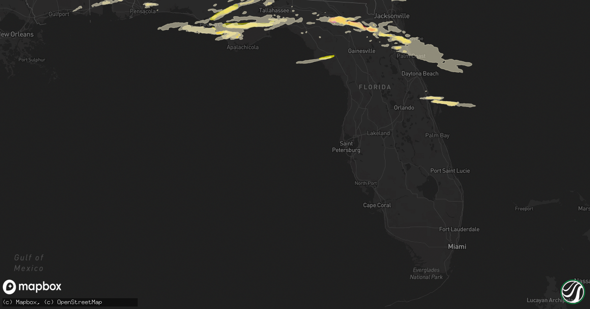
Hail Map in Florida on March 23, 2013
Get this storm
March 23 map
$229
one time, instant access
Download today. No call, no setup
Keep the $229
Bought the map and want the full workflow? Apply the entire $229 to a subscription within 7 days. None of it is wasted.
Every map, not just this one
This buys you this map. Subscription and you get every map we run, in the markets you choose from a few cities to whole states to nationwide. Plus real-time alerts the moment a storm fires.
Contact data
Name, contact info, occupancy, even credit band for addresses in the footprint. You go from where it hit to who to call.
Become the source they trust
Unlimited branding weather history reports on demand. You already have the documented answer ready for the property owner, and you are the one who showed up with it.
Property data and RoofTrace estimates
Pull up any address you have got, its value and the exact code rules for that jurisdiction, straight from One Click Code. Then RoofTrace estimates the squares, pitch, and roof value, priced the way you price.
Storm reports in Florida
Florida
| Date | Description |
|---|---|
| 03/23/20132:53 PM CDT | Severe strength winds produced damaged along federal point. Two homes had minor structural damage and numerous trees were blown down. Out buildings were damaged and pow |
| 03/23/20132:51 PM CDT | Severe thunderstorm winds damaged 8 homes near the west river road and mink road intersection. Homes had roof damage...numerous trees down...and out buildings damaged. |
| 03/23/20132:02 PM CDT | A local meterologist reported quarter sized hail off exit 318 heading towards the beach. |
| 03/23/20131:50 PM CDT | The public reported half dollar sized hail. |
| 03/23/20131:15 PM CDT | Quarter size hail reported at 241 churchill drive |
| 03/23/20131:00 PM CDT | Quarter size hail near camp blanding was observed. |
| 03/23/201312:55 PM CDT | The emergency manager reported that a barn was damaged and partially collapsed by high winds as well as vehicle damage. Reports of a funnel cloud at the time. The time |
| 03/23/201312:50 PM CDT | The emergency management reported a tree and powerlines blocking the roadway on county road 125 at northwest 63 avenue. The time given was based on radar. |
| 03/23/201312:50 PM CDT | The emergency manager received reports of baseball sized hail 3 miles west of lawtey near state road 225. The time given was based on radar. |
| 03/23/201312:40 PM CDT | The emergency manager reported trees blown down which blocked the roadways near 121 west and state road 16. The time given was based on radar. |
| 03/23/201312:11 PM CDT | Wruftv reported golf ball sized hail in lake city. |
| 03/23/201312:08 PM CDT | Broadcast media relayed reports of trees down along se margaret drive in lake city. Time is estimated from radar. |
| 03/23/201311:50 AM CDT | The emergency manager received reports of golf ball sized hail at wellborn. |
| 03/23/20139:54 AM CDT | Slightly larger than quarter size hail reported by motorist. |
| 03/23/20139:00 AM CDT | Via wctv social media. |
| 03/23/20138:47 AM CDT | Quarter size hail 5 ssw of crawfordville. |
| 03/23/20137:52 AM CDT | Via wjhg social media. |
| 03/23/20137:47 AM CDT | Via wjhg social media. |
| 03/23/20137:45 AM CDT | Quarter inch hail in wewahitchka. |
| 03/23/20137:41 AM CDT | Via wjhg social media. |
| 03/23/20137:41 AM CDT | Via wjhg social media. |
| 03/23/20137:29 AM CDT | Via wjhg social media. |
| 03/23/20137:15 AM CDT | Via wmbb social media. |
| 03/23/20136:50 AM CDT | Pine tree blown onto truck. |
| 03/23/20136:50 AM CDT | Trees blocking eastbound lanes of i10 at mile marker 199. Time estimated from radar. |
| 03/23/20136:20 AM CDT | Tree blocking bloxham cutoff. Time estimated by radar. |
All States Impacted by Hail Map on March 23, 2013
Cities Impacted by Hail Map on March 23, 2013
- Oak Hill, FL
- Edgewater, FL
- Lexington, MS
- Benton, MS
- Yazoo City, MS
- Pickens, MS
- Tifton, GA
- Eupora, MS
- Bellefontaine, MS
- Walthall, MS
- Meridian, MS
- Louin, MS
- Hickory, MS
- Chunky, MS
- Rose Hill, MS
- Raleigh, MS
- Enterprise, MS
- Philadelphia, MS
- Starkville, MS
- Carthage, MS
- Doddsville, MS
- Mathiston, MS
- Schlater, MS
- Woodland, MS
- Winona, MS
- Greenville, MS
- Indianola, MS
- Sunflower, MS
- Mantee, MS
- Kilmichael, MS
- Itta Bena, MS
- Leland, MS
- McGehee, AR
- McCarley, MS
- Holcomb, MS
- Grenada, MS
- Vardaman, MS
- Duck Hill, MS
- Shaw, MS
- Carrollton, MS
- Greenwood, MS
- Houston, MS
- Calhoun City, MS
- Stewart, MS
- Gore Springs, MS
- Maben, MS
- Lake Village, AR
- Coffeeville, MS
- Pheba, MS
- Arkansas City, AR
- Big Creek, MS
- Benoit, MS
- Dermott, AR
- Wills Point, TX
- Loxley, AL
- Robertsdale, AL
- Terrell, TX
- Kaufman, TX
- Waynesboro, MS
- Saint Augustine, FL
- West Point, MS
- Aberdeen, MS
- Lee, FL
- Glenwood, GA
- Youngstown, FL
- Altha, FL
- Clarksville, FL
- Fountain, FL
- Sopchoppy, FL
- Bristol, FL
- Wewahitchka, FL
- Nicholls, GA
- Alma, GA
- Live Oak, FL
- Vidalia, GA
- Milton, FL
- Linden, AL
- Gallion, AL
- Demopolis, AL
- Lisbon, LA
- Strong, AR
- El Dorado, AR
- Haynesville, LA
- Lillie, LA
- Summerfield, LA
- Huttig, AR
- Spearsville, LA
- Bernice, LA
- Homer, LA
- Junction City, AR
- Farmerville, LA
- Marion, LA
- Moultrie, GA
- Nashville, GA
- Pearson, GA
- Barney, GA
- Willacoochee, GA
- Adel, GA
- Axson, GA
- Douglas, GA
- Little Rock, MS
- Scooba, MS
- Collinsville, MS
- Porterville, MS
- Union, MS
- Emelle, AL
- De Kalb, MS
- Adrian, GA
- Kite, GA
- Marion Junction, AL
- Joshua, TX
- Forney, TX
- Crowley, TX
- Lancaster, TX
- Midlothian, TX
- Godley, TX
- Granbury, TX
- Desoto, TX
- Cresson, TX
- Grand Prairie, TX
- Crandall, TX
- Fort Worth, TX
- Red Oak, TX
- Cedar Hill, TX
- Mansfield, TX
- Balch Springs, TX
- Duncanville, TX
- Burleson, TX
- Alvarado, TX
- Lillian, TX
- Venus, TX
- Dallas, TX
- Hutchins, TX
- Wilmer, TX
- Scurry, TX
- Seagoville, TX
- Sturgis, MS
- Shuqualak, MS
- Louisville, MS
- Preston, MS
- Lawtey, FL
- Greenville, FL
- Lenox, GA
- Sallis, MS
- Wellborn, FL
- Lake City, FL
- Clanton, AL
- Troy, AL
- Glen Allan, MS
- Hamburg, AR
- Bastrop, LA
- Mer Rouge, LA
- Crossett, AR
- Mayersville, MS
- Oak Grove, LA
- Eudora, AR
- Bonita, LA
- Parkdale, AR
- Jones, LA
- Lake Providence, LA
- Wilmot, AR
- Goodman, MS
- Lake Butler, FL
- Valdosta, GA
- Quitman, GA
- Greensboro, AL
- White Oak, GA
- Woodbine, GA
- Climax, GA
- Ellisville, MS
- Akron, AL
- Moundville, AL
- Green Cove Springs, FL
- Silver City, MS
- West Blocton, AL
- Defuniak Springs, FL
- Hilliard, FL
- Brundidge, AL
- Banks, AL
- Goshen, AL
- Louisville, AL
- Vaughan, MS
- Camden, MS
- Kosciusko, MS
- Durant, MS
- Mims, FL
- Starke, FL
- Raiford, FL
- Forest, MS
- Bailey, MS
- Centreville, AL
- Lawley, AL
- Panama City, FL
- Elkton, FL
- Blackshear, GA
- Waycross, GA
- Forkland, AL
- Newbern, AL
- Ambrose, GA
- Lyons, GA
- Reidsville, GA
- Ovett, MS
- Moselle, MS
- Laurel, MS
- Okolona, MS
- Nettleton, MS
- Glennville, GA
- Fort Stewart, GA
- Claxton, GA
- Columbus, MS
- Crawford, MS
- Jacksonville, FL
- Toomsuba, MS
- Livingston, AL
- Marion, AL
- Uniontown, AL
- Lauderdale, MS
- York, AL
- Cuba, AL
- Ackerman, MS
- Weir, MS
- Naylor, GA
- Stockton, GA
- Du Pont, GA
- Fargo, GA
- Carrollton, AL
- Aliceville, AL
- Grady, AL
- Mathews, AL
- Ramer, AL
- Plantersville, AL
- Marion, MS
- Stanton, AL
- Maplesville, AL
- Perry, FL
- Canton, MS
- Equality, AL
- Sylacauga, AL
- Rockford, AL
- Goodwater, AL
- Kellyton, AL
- Weogufka, AL
- Alexander City, AL
- Rolling Fork, MS
- Ferris, TX
- Hahira, GA
- Lakeland, GA
- Berlin, GA
- Pavo, GA
- Coolidge, GA
- Sparks, GA
- Thomasville, GA
- Mershon, GA
- Lena, MS
- Crawfordville, FL
- Tallahassee, FL
- Havana, FL
- Twin City, GA
- Swainsboro, GA
- Soperton, GA
- Camden, AL
- Vredenburgh, AL
- Lower Peach Tree, AL
- Ocilla, GA
- Wray, GA
- Alapaha, GA
- Cleburne, TX
- Lamont, FL
- Middleburg, FL
- Norman Park, GA
- Omega, GA
- Hosford, FL
- Marianna, FL
- Sneads, FL
- Grand Ridge, FL
- Monticello, FL
- Cedarbluff, MS
- Mississippi State, MS
- McCool, MS
- Faunsdale, AL
- Dawson, GA
- Edison, GA
- Shellman, GA
- Morgan, GA
- Cuthbert, GA
- Shorterville, AL
- Abbeville, AL
- Columbia, AL
- Uvalda, GA
- Highland Home, AL
- Lapine, AL
- Selma, AL
- Morton, MS
- Fernandina Beach, FL
- Yulee, FL
- Brent, AL
- Sawyerville, AL
- Pelahatchie, MS
- Brandon, MS
- Palm Coast, FL
- Noxapater, MS
- Port Saint Joe, FL
- Macon, MS
- Horseshoe Beach, FL
- Old Town, FL
- Mendenhall, MS
- Glen Saint Mary, FL
- Orange Park, FL
- Saint Johns, FL
- Sanderson, FL
- Keystone Heights, FL
- Hastings, FL
- McAlpin, FL
- Madison, FL
- Fleming Island, FL
- Palatka, FL
- Mayo, FL
- White Springs, FL
- East Palatka, FL
- Thorsby, AL
- Blakely, GA
- Bluffton, GA
- Fort Gaines, GA
- Whatley, AL
- Coy, AL
- Grove Hill, AL
- Cadwell, GA
- McRae Helena, GA
- Alamo, GA
- Quincy, FL
- Blountstown, FL
- Chattahoochee, FL
- Chipley, FL
- Conehatta, MS
- Arlington, TX
- Newton, MS
- Louise, MS
- Dixie, GA
- Boston, GA
- Saint Marks, FL
- Eastpoint, FL
- Ponte Vedra Beach, FL
- Randolph, AL
- Coffeeville, AL
- Fort White, FL
- Sardis, GA
- Mount Vernon, GA
- Ailey, GA
- Savannah, GA
- Mobile, AL
- Theodore, AL
- Fort Deposit, AL
- Attapulgus, GA
- Bainbridge, GA
- Sylvania, GA
- Navarre, FL
- Thomasville, AL
- Pine Mountain Valley, GA
- Hamilton, GA
- Pine Mountain, GA
- Ray City, GA
- Ochlocknee, GA
- Morven, GA
- Walnut Grove, MS
- Hollandale, MS
- Anguilla, MS
- Chatham, MS
- Portland, AR
- Tarrytown, GA
- Greenville, AL
- Lake, MS
- Eutaw, AL
- Decatur, MS
- Boligee, AL
- Letohatchee, AL
- Hope Hull, AL
- Hampton, FL
- Ruleville, MS
- Boyle, MS
- Moorhead, MS
- Amory, MS
- Rohwer, AR
- Richmond Hill, GA
- Grand Saline, TX
- Epes, AL
- Verbena, AL
- Jemison, AL
- Gainesville, AL
- Minter, AL
- Forest Home, AL
- Prairie, MS
- Lulu, FL
- Cairo, GA
- Gretna, FL
- Panama City Beach, FL
- Whigham, GA
- Lynn Haven, FL
- Irvington, AL
- Grand Bay, AL
- Fitzpatrick, AL
- Daphne, AL
- Fairhope, AL
- Lisman, AL
- Jachin, AL
- Pennington, AL
- Ward, AL
- Headland, AL
- Leary, GA
- Arlington, GA
- Donalsonville, GA
- French Camp, MS
- Millen, GA
- Florahome, FL
- Tchula, MS
- Colquitt, GA
- Iron City, GA
- Brooksville, MS
- Vancleave, MS
- Gautier, MS
- Ocean Springs, MS
- Knoxville, AL
- Millwood, GA
- Chauncey, GA
- Eastman, GA
- Edgewood, TX
- Quitman, MS
- Pensacola, FL
- Waverly, GA
- Fruitvale, TX
- Canton, TX
- Mingus, TX
- Lipan, TX
- Gordon, TX
- Bluff Dale, TX
- Tolar, TX
- Stephenville, TX
- Ranger, TX
- Buffalo Gap, TX
- Tuscola, TX
- Merkel, TX
- Nolan, TX
- Abilene, TX
- Ovalo, TX
- Wingate, TX
- Loraine, TX
- Colorado City, TX
- Westbrook, TX
- Chiefland, FL


