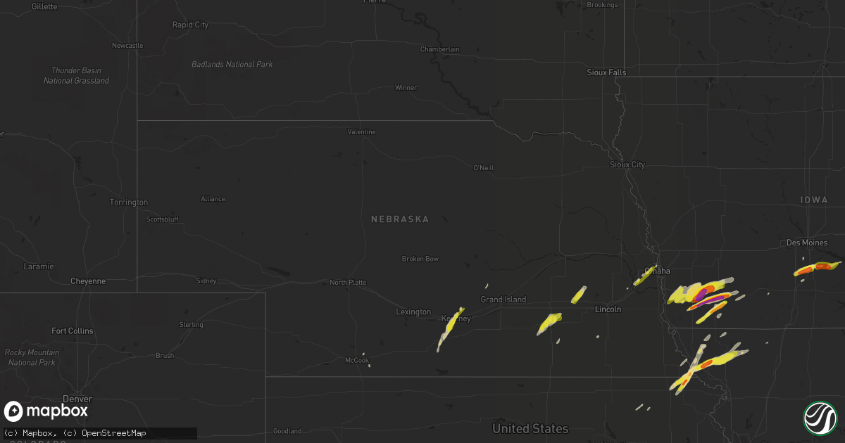
Hail Map in Nebraska on March 19, 2020
Get this storm
March 19 map
$229
one time, instant access
Download today. No call, no setup
Keep the $229
Bought the map and want the full workflow? Apply the entire $229 to a subscription within 7 days. None of it is wasted.
Every map, not just this one
This buys you this map. Subscription and you get every map we run, in the markets you choose from a few cities to whole states to nationwide. Plus real-time alerts the moment a storm fires.
Contact data
Name, contact info, occupancy, even credit band for addresses in the footprint. You go from where it hit to who to call.
Become the source they trust
Unlimited branding weather history reports on demand. You already have the documented answer ready for the property owner, and you are the one who showed up with it.
Property data and RoofTrace estimates
Pull up any address you have got, its value and the exact code rules for that jurisdiction, straight from One Click Code. Then RoofTrace estimates the squares, pitch, and roof value, priced the way you price.
Storm reports in Nebraska
Nebraska
| Date | Description |
|---|---|
| 03/19/20205:18 PM CDT | A local report indicates 1.00 inch wind near 2 W OMAHA |
| 03/19/20205:14 PM CDT | A local report indicates 1.25 inch wind near 2 SSE BOYS TOWN |
| 03/19/20205:14 PM CDT | A local report indicates 1.00 inch wind near 3 SE BOYS TOWN |
| 03/19/20205:10 PM CDT | A local report indicates 1.00 inch wind near 1 S CHALCO |
| 03/19/20205:05 PM CDT | A local report indicates 1.00 inch wind near 2 S STAPLEHURST |
| 03/19/20204:15 PM CDT | Quarter to half dollar sized hail. |
| 03/19/20203:59 PM CDT | Hail covered the ground. Mostly peas... Some hail as large as quarters mixed in. |
| 03/19/20203:12 PM CDT | Mostly 1/2 to 3/4 inch but there was one stone slightly bigger than 1 inch. |
| 03/19/20203:04 PM CDT | This lsr reflects a corrected location...was initially sent as 1 ne kearney. |
| 03/19/20203:04 PM CDT | A local report indicates 1.25 inch wind near 1 NE KEARNEY |
| 03/19/20202:46 PM CDT | Mostly pea to nickel with a few quarters. Hail 2 inches deep in yard. |
| 03/19/20201:58 AM CDT | At 657 PM CDT, a severe thunderstorm was located near Mound City, moving northeast at 55 mph. A second storm is located east of Fairfax, and is moving northeast at 50 mph. This storm is also capable of producing quarter to golf ball sized hail. HAZARD...Golf ball size hail and 60 mph wind gusts. SOURCE...Radar indicated. IMPACT...People and animals outdoors will be injured. Expect hail damage to roofs, siding, windows, and vehicles. Expect wind damage to roofs, siding, and trees. Locations impacted include... Maryville, Mound City, Burlington Junction, Maitland, Skidmore, Craig, Graham, Big Lake, Arkoe, Quitman, Fortescue and Bigelow.This includes Interstate 29 between mile markers 79 and 95. |
| 03/19/20201:24 AM CDT | At 623 PM CDT, a severe thunderstorm was located 7 miles northwest of White Cloud, or 10 miles east of Falls City, moving northeast at 55 mph. HAZARD...60 mph wind gusts and quarter size hail. SOURCE...Radar indicated. IMPACT...Hail damage to vehicles is expected. Expect wind damage to roofs, siding, and trees. Locations impacted include... Mound City, Maitland, Skidmore, Craig, Graham, Big Lake, Quitman, Fortescue and Bigelow.This includes Interstate 29 between mile markers 79 and 94. |
| 03/19/20201:06 AM CDT | At 605 PM CDT, a severe thunderstorm was located near Powhattan, moving northeast at 40 mph. HAZARD...Ping pong ball size hail and 60 mph wind gusts. SOURCE...Radar indicated. IMPACT...People and animals outdoors will be injured. Expect hail damage to roofs, siding, windows, and vehicles. Expect wind damage to roofs, siding, and trees. Locations impacted include... Hiawatha, Horton, Fairview, Robinson, Powhattan, Hamlin, Willis and Kickapoo Reservation. |
| 03/19/202012:18 AM CDT | At 518 PM CDT, a severe thunderstorm was located over southern Omaha, moving northeast at 45 mph. HAZARD...Quarter size hail. SOURCE...Radar indicated. IMPACT...Damage to vehicles is expected. Locations impacted include... Omaha, Council Bluffs, Ralston, Carter Lake, Boys Town, Crescent and Narrows River Park.This includes the following highways... Interstate 29 between mile markers 50 and 61. Interstate 80 in Iowa between mile markers 1 and 3, and near milemarker 5. Interstate 80 in Nebraska between mile markers 446 and 454. |
| 03/19/202012:00 AM CDT | At 459 PM CDT, a severe thunderstorm was located over Staplehurst, or 22 miles east of York, moving northeast at 35 mph. HAZARD...60 mph wind gusts and quarter size hail. SOURCE...Radar indicated. IMPACT...Hail damage to vehicles is expected. Expect wind damage to roofs, siding, and trees. Locations impacted include... Seward, Brainard, Staplehurst, Dwight and Bee. |
| 03/18/202011:24 PM CDT | At 424 PM CDT, a severe thunderstorm was located near McCool Junction, or 11 miles southeast of York, moving northeast at 30 mph. HAZARD...Quarter size hail. SOURCE...Radar indicated. IMPACT...Damage to vehicles is expected. Locations impacted include... Exeter, McCool Junction, Waco, Gresham and Thayer. This includes Interstate 80 between mile markers 355 and 365. |
| 03/18/202010:56 PM CDT | At 355 PM CDT, a severe thunderstorm was located over Grafton, or 20 miles south of York, moving northeast at 30 mph. HAZARD...Quarter size hail. SOURCE...Radar indicated. IMPACT...Damage to vehicles is expected. Locations impacted include... Fairmont, McCool Junction, Grafton and Lushton. This includes Interstate 80 between mile markers 347 and 354. |
| 03/18/202010:34 PM CDT | At 333 PM CDT, a severe thunderstorm was located east of Dorchester, or 20 miles southwest of Lincoln, moving northeast at 45 mph. HAZARD...60 mph wind gusts and quarter size hail. SOURCE...Radar indicated. IMPACT...Hail damage to vehicles is expected. Expect wind damage to roofs, siding, and trees. Locations impacted include... Southwestern Lincoln, Crete, Pleasant Dale, Denton, Pawnee State Recreation Area, Walnut Creek Recreation Area and Conestoga State Recreation Area.This includes Interstate 80 in Nebraska between mile markers 388 and395. |
| 03/18/202010:25 PM CDT | At 325 PM CDT, a severe thunderstorm was located over Edgar, or 28 miles southeast of Hastings, moving north at 30 mph. HAZARD...Quarter size hail. SOURCE...Radar indicated. IMPACT...Damage to vehicles is expected. Locations impacted include... Edgar and Ong. |
| 03/18/20209:43 PM CDT | At 243 PM CDT, a severe thunderstorm was located near Axtell, or 11 miles southwest of Kearney, moving northeast at 25 mph. HAZARD...Quarter size hail. SOURCE...Radar indicated. IMPACT...Damage to vehicles is expected. Locations impacted include... Kearney and Riverdale. This includes Interstate 80 between mile markers 265 and 281. |
All States Impacted by Hail Map on March 19, 2020
Cities Impacted by Hail Map on March 19, 2020
- Gretna, NE
- Cleveland, AR
- Clinton, AR
- Scotland, AR
- Funk, NE
- Axtell, NE
- Kearney, NE
- Waldron, AR
- Omaha, NE
- Emerson, IA
- Red Oak, IA
- New Virginia, IA
- Osceola, IA
- Electra, TX
- Harrold, TX
- Asherton, TX
- Catarina, TX
- Rulo, NE
- Hiawatha, KS
- Craig, MO
- Falls City, NE
- Indianola, IA
- Ravenwood, MO
- Clyde, MO
- Stanberry, MO
- Del Rio, TX
- Pleasantville, IA
- Knoxville, IA
- Morrill, KS
- White Cloud, KS
- Dallas, TX
- Granbury, TX
- Holdrege, NE
- Maitland, MO
- Mound City, MO
- Graham, MO
- Essex, IA
- Stanton, IA
- Villisca, IA
- Clarinda, IA
- Nodaway, IA
- Laredo, TX
- Crystal City, TX
- Pearsall, TX
- Quemado, TX
- Eagle Pass, TX
- Batesville, TX
- La Pryor, TX
- Burleson, TX
- Crowley, TX
- Rocksprings, TX
- Staplehurst, NE
- Bee, NE
- Seward, NE
- Utica, NE
- Ulysses, NE
- Dwight, NE
- Sutton, NE
- Grafton, NE
- Cumberland, IA
- Elliott, IA
- Corning, IA
- Hastings, IA
- Glenwood, IA
- Malvern, IA
- Imogene, IA
- Tabor, IA
- Randolph, IA
- Konawa, OK
- Tolar, TX
- Edgemont, AR
- Mountain View, AR
- Iowa Park, TX
- Grandfield, OK
- Devol, OK
- Fairfax, MO
- Shenandoah, IA
- Barnard, MO
- Maryville, MO
- Centralia, KS
- Vermillion, KS
- Conception Junction, MO
- Skidmore, MO
- Lipan, TX
- Ponder, TX
- Justin, TX
- Krum, TX
- Gatesville, TX
- Atkins, AR
- Jerusalem, AR
- Russellville, AR
- Hector, AR
- Moore, TX
- Aubrey, TX
- Naval Air Station Jrb, TX
- Fort Worth, TX
- Joshua, TX
- Marlow, OK
- Fletcher, OK
- McCool Junction, NE
- Fairmont, NE
- Coin, IA
- Yorktown, IA
- West College Corner, IN
- Liberty, IN
- College Corner, OH
- Oxford, OH
- Alma, NE
- Camden, OH
- Brookville, IN
- Bath, IN
- Somerville, OH
- Hamilton, OH
- Bradley, OK
- Geneva, NE
- Cotulla, TX
- Big Wells, TX
- Dannebrog, NE
- Cairo, NE
- Broken Bow, OK
- Goldthwaite, TX
- Paris, TX
- Powderly, TX
- Carrizo Springs, TX
- Booneville, AR
- Rushville, IN
- Weatherford, TX
- Coppell, TX
- Irving, TX
- Grapevine, TX
- Addison, TX
- Carrollton, TX
- Flower Mound, TX
- Ackworth, IA
- Saint Charles, IA
- Milo, IA
- Shirley, AR
- Lindsay, OK
- Alex, OK
- Rush Springs, OK
- Tilden, TX
- Jourdanton, TX
- Charlotte, TX
- Fowlerton, TX
- Ashland, NE
- Delaware, AR
- Southlake, TX
- Colleyville, TX
- Lewisville, TX
- Plano, TX
- Bigfoot, TX
- Farragut, IA
- Mullin, TX
- Afton, IA
- Aledo, TX
- Indianola, NE
- Comstock, TX
- Waxahachie, TX
- Ohiowa, NE
- Strang, NE
- Honey Grove, TX
- Grand Prairie, TX
- Duncanville, TX
- Hamilton, TX
- Hampton, NE
- Aurora, NE
- Pacific Junction, IA
- Massena, IA
- Henderson, IA
- Prescott, IA
- Lenox, IA
- Valley Mills, TX
- Connersville, IN
- Laurel, IN
- Metamora, IN
- Cranfills Gap, TX
- Clifton, TX
- Creston, IA
- Edgar, NE
- Exeter, NE
- York, NE
- Pleasant Grove, AR
- Loveland, OK
- Allen, OK
- Calvin, OK
- George West, TX
- Three Rivers, TX
- Grandview, TX
- Cedar Hill, TX
- Arlington, TX
- Desoto, TX
- Dardanelle, AR
- Lampasas, TX
- Denton, TX
- Bonham, TX
- Lometa, TX
- Purmela, TX
- Fairview, KS
- Sabetha, KS
- Parnell, MO
- Gentry, MO
- Powhattan, KS
- Alvarado, TX
- Sumner, TX
- Walters, OK
- Venus, TX
- Mansfield, TX
- Godley, TX
- Middletown, OH
- Milroy, IN
- Greensburg, IN
- Telephone, TX
- Tarkio, MO
- Elmo, MO
- Burlington Junction, MO
- Corning, KS
- Geronimo, OK
- Purcell, OK
- Blanchard, OK
- Ninnekah, OK
- Cleburne, TX
- Covington, TX
- Rio Vista, TX
- Blum, TX
- Danville, AR
- Copperas Cove, TX
- Dilley, TX
- Martinsville, MO
- Denver, MO
- Hopkins, MO
- Clearmont, MO
- Wayne, OK
- Maysville, OK
- Clatonia, NE
- Whitney, TX
- Truro, IA
- Frost, TX
- Lawton, OK
- North Richland Hills, TX
- Keller, TX
- Santo, TX
- Bluff Dale, TX
- Dover, AR
- Pauls Valley, OK
- Northboro, IA
- Thurman, IA
- Melcher Dallas, IA
- Lacona, IA
- Miamisburg, OH
- Germantown, OH
- La Vista, NE
- Ozark, AR
- Roland, OK
- Van Buren, AR
- Alma, AR
- Muldrow, OK
- Fort Smith, AR
- Mulberry, AR
- Bokoshe, OK
- Keota, OK
- Mccurtain, OK
- Spiro, OK
- Gassville, AR
- Summit, AR
- Cotter, AR
- Kingston, AR
- Parthenon, AR
- Pettigrew, AR
- Gamaliel, AR
- Harrison, AR
- Flippin, AR
- Hasty, AR
- Jasper, AR
- Western Grove, AR
- Caulfield, MO
- Everton, AR
- Bakersfield, MO
- Mountain Home, AR
- Yellville, AR
- Ponca, AR
- Mena, AR
- London, AR
- Belleville, AR
- Havana, AR
- Pottsville, AR
- Mount Pleasant, AR
- Sidney, AR
- Sage, AR
- Guion, AR
- Melbourne, AR
- Horseshoe Bend, AR
- Evening Shade, AR
- Benton, IL
- Mulkeytown, IL
- Barnhill, IL
- Whittington, IL
- Bonnie, IL
- Sesser, IL
- Fairfield, IL
- Waltonville, IL
- Scheller, IL
- Wayne City, IL
- Ina, IL
- Du Quoin, IL
- Mill Shoals, IL
- Belle Rive, IL
- Dahlgren, IL
- Tamaroa, IL
- Weleetka, OK
- Okemah, OK
- Tecumseh, OK
- Maud, OK
- Wewoka, OK
- Henryetta, OK
- Earlsboro, OK
- Macomb, OK
- Seminole, OK
- Okmulgee, OK
- Wetumka, OK
- Stilwell, OK
- Canehill, AR
- Evansville, AR
- Lincoln, AR
- Bunch, OK
- Checotah, OK
- Council Hill, OK
- Drumright, OK
- Stuart, OK


