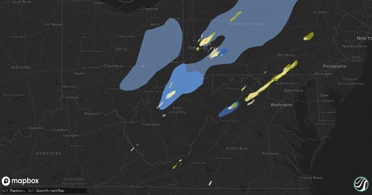
Hail Map in West Virginia on March 16, 2025
Get this storm
March 16 map
$229
one time, instant access
Download today. No call, no setup
Keep the $229
Bought the map and want the full workflow? Apply the entire $229 to a subscription within 7 days. None of it is wasted.
Every map, not just this one
This buys you this map. Subscription and you get every map we run, in the markets you choose from a few cities to whole states to nationwide. Plus real-time alerts the moment a storm fires.
Contact data
Name, contact info, occupancy, even credit band for addresses in the footprint. You go from where it hit to who to call.
Become the source they trust
Unlimited branding weather history reports on demand. You already have the documented answer ready for the property owner, and you are the one who showed up with it.
Property data and RoofTrace estimates
Pull up any address you have got, its value and the exact code rules for that jurisdiction, straight from One Click Code. Then RoofTrace estimates the squares, pitch, and roof value, priced the way you price.
Storm reports in West Virginia
West Virginia
| Date | Description |
|---|---|
| 03/16/20256:30 PM CDT | Tree down |
| 03/16/20256:30 PM CDT | Tree down at the 1800 block of dry run rd between hedgesville and martinsburg |
| 03/16/20256:08 PM CDT | Tree down at the 1800 block of dry run rd between hedgesville and martinsburg |
| 03/16/20255:32 PM CDT | One inch hail |
| 03/16/20254:15 PM CDT | A tree was down along cresview lane near quain acres lane. |
| 03/16/20253:22 PM CDT | 911 center reported a few trees down in hardy county. |
| 03/16/20253:19 PM CDT | 911 center reported trees down across the county. |
| 03/16/20252:04 PM CDT | Local plant nursery along rt-92... North of frost reported a tree down on property about a foot and a half in diameter. They also advised there was some small hail in t |
| 03/16/20252:04 PM CDT | Co-op observer in dunmore reported multiple trees down between dunmore and frost on the way to lewisburg. Time estimated by radar. |
| 03/16/20251:39 PM CDT | Co-op observer in dunmore reported multiple trees down north of dunmore along route 28. Time estimated via radar. |
| 03/16/20251:14 PM CDT | Tree down at the 600 block of piedmont rd |
| 03/16/20251:05 PM CDT | Down trees on county road 45. |
| 03/16/20251:05 PM CDT | Trees down. |
| 03/16/202512:56 PM CDT | Corrects previous tstm wnd dmg report from 3 s meadow bluff. Large tree down blocking road. Time estimated from radar. |
| 03/16/202512:55 PM CDT | Tree down on seneca trail. |
| 03/16/202512:35 PM CDT | A large tree blocking the road. |
| 03/16/202512:30 PM CDT | Tree and telephone lines down on road. Time estimated. |
| 03/16/202512:15 PM CDT | Roof of the phil gainer community center damaged by wind. |
| 03/16/202512:05 PM CDT | Skywarn ke8tuz reports snapped power pole on van vorhees road. Power outage resulted north of the ruby memorial hospital. |
| 03/16/202512:02 PM CDT | Trees down. |
| 03/16/202511:58 AM CDT | Tree down in road. Time estimated. |
| 03/16/202511:53 AM CDT | Tree and wires down along north preston highway. Time estimated. |
| 03/16/202511:53 AM CDT | Tree down in the road and power lines down at long hollow road and pebble rock lane. |
| 03/16/202511:53 AM CDT | Tree down on power line blocking road at 235 f road arthurdale. Time estimated by radar. |
| 03/16/202511:52 AM CDT | Tree down on webster rd over mcguire mtn. |
| 03/16/202511:51 AM CDT | Two trees down blocking both lanes at intersection of sunny hill road and nuce road. Time estimated by radar. |
| 03/16/202511:51 AM CDT | Tree down... Blocking the road. Time estimated. |
| 03/16/202511:49 AM CDT | Trees down. |
| 03/16/202511:47 AM CDT | Two trees down near the intersection of nuce road and sunny hill road. Time estimated. |
| 03/16/202511:45 AM CDT | Power lines down. |
| 03/16/202511:45 AM CDT | Large branches on county route 92. Time estimated. |
| 03/16/202511:45 AM CDT | Trees down. |
| 03/16/202511:45 AM CDT | Tree and power lines on the road. Time estimated. |
| 03/16/202511:45 AM CDT | Tree down blocking one lane of the road. Time estimated. |
| 03/16/202511:42 AM CDT | Tree down on power lines and power lines are sparking. |
| 03/16/202511:40 AM CDT | Large tree down at intersection of stafford street and herman avenue. Time estimated via radar. |
| 03/16/202511:38 AM CDT | Tree and phone line down across phillips dairy rd. |
| 03/16/202511:35 AM CDT | Several trees reported down between summersville and curtin. |
| 03/16/202511:35 AM CDT | Tree damage... Debris in the roadway. |
| 03/16/202511:35 AM CDT | Tree on a house. |
| 03/16/202511:33 AM CDT | Tree down with power lines down. Time estimated by radar. |
| 03/16/202511:30 AM CDT | Trees down. |
| 03/16/202511:30 AM CDT | One large hardwood tree uprooted and a couple of large pine trees damaged. |
| 03/16/202511:30 AM CDT | Multiple downed trees... Fence and siding damage. Much airborne debris. |
| 03/16/202511:30 AM CDT | Tree down on a house. |
| 03/16/202511:30 AM CDT | Multiple trees and lines down in and around grafton and countywide. |
| 03/16/202511:30 AM CDT | Tree down blocking part of rt 20. |
| 03/16/202511:30 AM CDT | Trees down. |
| 03/16/202511:28 AM CDT | Trees down on levels road... Blocking road. Time estimated. |
| 03/16/202511:28 AM CDT | Substantial roof damage and partial building collapse. |
| 03/16/202511:27 AM CDT | Trees down. |
| 03/16/202511:25 AM CDT | Trees down. |
| 03/16/202511:25 AM CDT | Trees and large branches down |
| 03/16/202511:25 AM CDT | Trees and branches down. |
| 03/16/202511:25 AM CDT | Hickory trees fell onto home. |
| 03/16/202511:20 AM CDT | Numerous trees and wires down. |
| 03/16/202511:20 AM CDT | Tree onto a house. |
| 03/16/202511:17 AM CDT | Trees across road and live power lines down. Time estimated by radar. |
| 03/16/202511:15 AM CDT | Corrects previous non-tstm wnd gst report from 2 ene bridgeport. Asos station kckb clarksburg airport. |
| 03/16/202511:15 AM CDT | Structural damage and debris. |
| 03/16/202511:15 AM CDT | Multiple trees and powerlines down blocking roads across southern end of the county. |
| 03/16/202511:15 AM CDT | Uprooted trees... Siding torn off of porch and part of roof blown off house. |
| 03/16/202511:15 AM CDT | Corrects previous non-tstm wnd gst report from 2 ene bridgeport. Asos station kckb clarksburg airport. |
| 03/16/202511:12 AM CDT | Power company reports a weather-related outage in association with the thunderstorms that moved through. |
| 03/16/202511:10 AM CDT | Measured on a personal weather station. |
| 03/16/202511:10 AM CDT | Social media post showing damage from the laurel valley area... With siding ripped off the wall of a house... And another house with a partially collapsed wall. Also se |
| 03/16/202511:10 AM CDT | Measur |
| 03/16/202511:10 AM CDT | Storm door was torn off the frame on back porch. |
| 03/16/202511:10 AM CDT | A portion of a wall was ripped off the side of a garage. |
| 03/16/202511:09 AM CDT | Trees and power lines down. |
| 03/16/202511:05 AM CDT | Update to add information to previous report. Wall from a building fell into the roadway. Also... Numerous trees and powerlines down and across roads in town and over t |
| 03/16/202511:05 AM CDT | Wall from a building fell into the roadway. |
| 03/16/202511:04 AM CDT | Multiple trees down in clarksburg with the roof blown off an apartment building. |
| 03/16/202511:03 AM CDT | Trees down. |
| 03/16/202511:00 AM CDT | Tree down in the road. |
| 03/16/202511:00 AM CDT | Tree down. |
| 03/16/202511:00 AM CDT | Multiple trees and powerlines down between west union and clarksburg. |
| 03/16/202511:00 AM CDT | Trees down in flatwoods and heaters. |
| 03/16/202511:00 AM CDT | Tree down. |
| 03/16/202510:59 AM CDT | 911 center reported downed trees and powerlines in the area. Time estimated based on radar. |
| 03/16/202510:57 AM CDT | Power lines down in lester community. |
| 03/16/202510:57 AM CDT | 911 center reported a tree down onto the awning of a home. Time estimated based on radar. |
| 03/16/202510:55 AM CDT | Trampoline blown away and lattice ripped from a front porch of a home. |
| 03/16/202510:53 AM CDT | 911 center reported downed tree on washington lands road. Time estimated based on radar. |
| 03/16/202510:50 AM CDT | Tree reported down on walnut fork road. |
| 03/16/202510:50 AM CDT | Trees down in burnsville. |
| 03/16/202510:47 AM CDT | 911 center reported downed trees in the area. Time estimated based on radar. |
| 03/16/202510:45 AM CDT | Trees down blocking rt 18 in a couple of places. |
| 03/16/202510:45 AM CDT | Multiple trees and powerlines down including vadis rd and simms run. |
| 03/16/202510:42 AM CDT | Tree reported down across the road near the intersection of county road 18 and pitts run. |
| 03/16/202510:41 AM CDT | Tree down on walnut fork rd. |
| 03/16/202510:41 AM CDT | Multiple trees down. |
| 03/16/202510:40 AM CDT | Numerous trees and powerlines down blocking roads from glenville to the lewis co line. |
| 03/16/202510:37 AM CDT | A storm door was torn off the frame. |
| 03/16/202510:35 AM CDT | Power lines down blocking the road. |
| 03/16/202510:25 AM CDT | Roof blown off of a structure. |
| 03/16/202510:25 AM CDT | Multiple trees and powerlines down in and around town. |
| 03/16/202510:22 AM CDT | Time is estimated by radar. |
| 03/16/202510:20 AM CDT | Tree down in bickmore. |
| 03/16/202510:20 AM CDT | Tree down in big otter. |
| 03/16/202510:16 AM CDT | Couple trees blown down near intersection of snowbird rd and us 50. |
| 03/16/202510:15 AM CDT | Trees down north of grantsville... Including yellow creek rd... Leading creek rd and on w little kanawha hwy. |
| 03/16/202510:10 AM CDT | Trees down on elk river rd. |
| 03/16/202510:10 AM CDT | Trees down in shrewsbury. |
| 03/16/202510:02 AM CDT | Several trees down east of spencer... Including arnoldsburg rd... Steel hollow rd... And clay rd. |
| 03/16/202510:00 AM CDT | Trees down on blue creek rd. |
| 03/16/20259:42 AM CDT | Tree down blocking both lanes of holden rd. |
| 03/16/20259:40 AM CDT | Tree down blocking hewett creek rd. |
| 03/16/20259:40 AM CDT | Tree down blocking kanawha blvd at clendenin st. |
| 03/16/20259:00 AM CDT | Tree fell onto a cut a fiber line up lower mud river rd. |
| 03/16/20258:48 AM CDT | Multiple trees reported down in cabwaylingo state forest. |
| 03/15/20257:34 PM CDT | A local report indicates 1.00 inch wind near Charles Town |
All States Impacted by Hail Map on March 16, 2025
Cities Impacted by Hail Map on March 16, 2025
- Fresno, OH
- Baltic, OH
- Stone Creek, OH
- Sugarcreek, OH
- New Philadelphia, OH
- South Williamson, KY
- Sidney, KY
- Belfry, KY
- Canada, KY
- Williamson, WV
- Delbarton, WV
- Forest Hills, KY
- Spencer, WV
- Creston, WV
- Reedy, WV
- Harrisville, WV
- Smithville, WV
- Macfarlan, WV
- Left Hand, WV
- Newton, WV
- Amma, WV
- Looneyville, WV
- Pennsboro, WV
- Pullman, WV
- Berea, WV
- Auburn, WV
- West Union, WV
- New Milton, WV
- Salem, WV
- Alma, WV
- Mount Clare, WV
- Clarksburg, WV
- Lost Creek, WV
- Meadowbrook, WV
- Hepzibah, WV
- Lumberport, WV
- Wallace, WV
- Bridgeport, WV
- Shinnston, WV
- Center Point, WV
- Spelter, WV
- Flemington, WV
- Fairmont, WV
- Grafton, WV
- Anmoore, WV
- Morgantown, WV
- Independence, WV
- Enterprise, WV
- Worthington, WV
- Navarre, OH
- Dalton, OH
- North Lawrence, OH
- Orrville, OH
- Canton, OH
- Canal Fulton, OH
- Massillon, OH
- Brewster, OH
- Clinton, OH
- Akron, OH
- Uniontown, OH
- North Canton, OH
- Hartville, OH
- Louisville, OH
- Middlebranch, OH
- Alliance, OH
- Arthurdale, WV
- Reedsville, WV
- Newburg, WV
- Masontown, WV
- Indianola, PA
- Cheswick, PA
- New Kensington, PA
- Pittsburgh, PA
- Oakmont, PA
- Harwick, PA
- Allison Park, PA
- Verona, PA
- Russellton, PA
- Tarentum, PA
- Gibsonia, PA
- Bakerstown, PA
- Glenshaw, PA
- Springdale, PA
- Creighton, PA
- Natrona Heights, PA
- Brackenridge, PA
- Sarver, PA
- Leechburg, PA
- Freeport, PA
- Vandergrift, PA
- Hyde Park, PA
- Kittanning, PA
- Ford City, PA
- Ford Cliff, PA
- McGrann, PA
- Templeton, PA
- Saxonburg, PA
- Valencia, PA
- Butler, PA
- Baden, PA
- McKees Rocks, PA
- Apollo, PA
- Manorville, PA
- Brunswick, GA
- Masontown, PA
- Garards Fort, PA
- Jefferson, PA
- Carmichaels, PA
- Rices Landing, PA
- Greensboro, PA
- Ronco, PA
- Nemacolin, PA
- Clarksville, PA
- Hopwood, PA
- New Salem, PA
- Dunbar, PA
- Oliver, PA
- Republic, PA
- Lemont Furnace, PA
- Brownsville, PA
- Crucible, PA
- Fairbank, PA
- Uledi, PA
- Smock, PA
- McClellandtown, PA
- Smithfield, PA
- Cardale, PA
- East Millsboro, PA
- Uniontown, PA
- Adah, PA
- Grindstone, PA
- Merrittstown, PA
- Mount Braddock, PA
- Allenport, PA
- West Newton, PA
- Alverton, PA
- Coal Center, PA
- Denbo, PA
- New Stanton, PA
- Elco, PA
- Perryopolis, PA
- Vanderbilt, PA
- Latrobe, PA
- Wyano, PA
- Fayette City, PA
- Dawson, PA
- Ruffs Dale, PA
- Millsboro, PA
- Tarrs, PA
- Hiller, PA
- Yukon, PA
- Bovard, PA
- Pleasant Unity, PA
- Hunker, PA
- California, PA
- Smithton, PA
- Scottdale, PA
- Vestaburg, PA
- Luxor, PA
- Roscoe, PA
- Youngwood, PA
- Stockdale, PA
- Dickerson Run, PA
- Connellsville, PA
- Everson, PA
- Allison, PA
- Wickhaven, PA
- La Belle, PA
- Newell, PA
- Star Junction, PA
- New Alexandria, PA
- Belle Vernon, PA
- Mount Pleasant, PA
- Fredericktown, PA
- Keisterville, PA
- Greensburg, PA
- Waltersburg, PA
- Daisytown, PA
- West Leisenring, PA
- Melcroft, PA
- Derry, PA
- Laughlintown, PA
- Somerset, PA
- Boswell, PA
- Jennerstown, PA
- Jones Mills, PA
- Rockwood, PA
- Loyalhanna, PA
- Youngstown, PA
- Stahlstown, PA
- Jenners, PA
- Friedens, PA
- Mill Run, PA
- Normalville, PA
- Central City, PA
- Acme, PA
- Shanksville, PA
- Hidden Valley, PA
- Bradenville, PA
- White, PA
- Hostetter, PA
- Champion, PA
- Indian Head, PA
- Stoystown, PA
- Quecreek, PA
- Gray, PA
- Rector, PA
- Ligonier, PA
- Acosta, PA
- Donegal, PA
- Westover, PA
- Nicktown, PA
- Davidsville, PA
- Patton, PA
- La Jose, PA
- Jerome, PA
- Robinson, PA
- Coral, PA
- Mineral Point, PA
- Cairnbrook, PA
- Armagh, PA
- Marsteller, PA
- Johnstown, PA
- Saint Benedict, PA
- South Fork, PA
- Brush Valley, PA
- Belsano, PA
- Spangler, PA
- Seward, PA
- Nanty Glo, PA
- Elmora, PA
- Twin Rocks, PA
- New Derry, PA
- Northern Cambria, PA
- New Florence, PA
- Saint Michael, PA
- Elton, PA
- Carrolltown, PA
- Windber, PA
- Hastings, PA
- Summerhill, PA
- Clymer, PA
- Ebensburg, PA
- Alverda, PA
- Homer City, PA
- Emeigh, PA
- Indiana, PA
- Penn Run, PA
- Dilltown, PA
- Parkhill, PA
- Josephine, PA
- Mentcle, PA
- Colver, PA
- Cherry Tree, PA
- Bolivar, PA
- Vintondale, PA
- Strongstown, PA
- Salix, PA
- Hollsopple, PA
- Heilwood, PA
- Sidman, PA
- Seanor, PA
- Blairsville, PA
- Black Lick, PA
- Hooversville, PA
- Loretto, PA
- Beaverdale, PA
- Portage, PA
- Saint Boniface, PA
- Lilly, PA
- Wilmore, PA
- Alum Bank, PA
- New Paris, PA
- Schellsburg, PA
- East Freedom, PA
- Duncansville, PA
- Queen, PA
- Cresson, PA
- Claysburg, PA
- Dysart, PA
- Chest Springs, PA
- Gallitzin, PA
- Ashville, PA
- Imler, PA
- Cassandra, PA
- Osterburg, PA
- Coalport, PA
- Rockton, PA
- Penfield, PA
- Flinton, PA
- Du Bois, PA
- Altoona, PA
- Mahaffey, PA
- Ridgway, PA
- Curwensville, PA
- Grampian, PA
- Kersey, PA
- Irvona, PA
- Brockport, PA
- Luthersburg, PA
- Johnsonburg, PA
- Commodore, PA
- Stump Creek, PA
- Starford, PA
- Reynoldsville, PA
- Glen Campbell, PA
- Big Run, PA
- Troutville, PA
- Arcadia, PA
- Rossiter, PA
- Brockway, PA
- Sykesville, PA
- Falls Creek, PA
- Burnside, PA
- Gipsy, PA
- Dixonville, PA
- Lucernemines, PA
- Rochester Mills, PA
- Hillsdale, PA
- Punxsutawney, PA
- Ernest, PA
- Marion Center, PA
- Saint Marys, PA
- Weedville, PA
- Benezett, PA
- Hollidaysburg, PA
- Newry, PA
- Williamsburg, PA
- Blandburg, PA
- Madera, PA
- Glen Hope, PA
- Tyrone, PA
- West Decatur, PA
- Tipton, PA
- Ramey, PA
- Clearfield, PA
- Roaring Spring, PA
- Philipsburg, PA
- Glen Richey, PA
- Fallentimber, PA
- New Millport, PA
- Hyde, PA
- Olanta, PA
- Houtzdale, PA
- Smithmill, PA
- Bellwood, PA
- Beccaria, PA
- Brisbin, PA
- Morrisdale, PA
- Osceola Mills, PA
- Frenchville, PA
- Wilcox, PA
- Byrnedale, PA
- Sandy Ridge, PA
- Wallaceton, PA
- Force, PA
- Bigler, PA
- Crosby, PA
- Smethport, PA
- Mineral Springs, PA
- Woodland, PA
- Driftwood, PA
- Emporium, PA
- Port Allegany, PA
- Huntingdon, PA
- Grassflat, PA
- Allport, PA
- Hawk Run, PA
- Alexandria, PA
- Pennsylvania Furnace, PA
- Warriors Mark, PA
- Spruce Creek, PA
- Munson, PA
- Kylertown, PA
- Winburne, PA
- Lanse, PA
- Port Matilda, PA
- Drifting, PA
- Petersburg, PA
- Karthaus, PA
- Pottersdale, PA
- Sinnamahoning, PA
- Roulette, PA
- Austin, PA
- Coudersport, PA
- Julian, PA
- Westport, PA
- Moshannon, PA
- Cadogan, PA
- Genesee, PA
- Clarence, PA
- Andover, NY
- Ulysses, PA
- Renovo, PA
- Snow Shoe, PA
- Wellsville, NY
- Galeton, PA
- Whitesville, NY
- Cross Fork, PA
- Mill Creek, PA
- Beech Creek, PA
- State College, PA
- Bellefonte, PA
- Lemont, PA
- University Park, PA
- Pine Grove Mills, PA
- Belleville, PA
- Fleming, PA
- Allensville, PA
- Orviston, PA
- McVeytown, PA
- Boalsburg, PA
- Centre Hall, PA
- Milesburg, PA
- Howard, PA
- Lewistown, PA
- Rexville, NY
- Troupsburg, NY
- Mills, PA
- Canisteo, NY
- North Bend, PA
- Lock Haven, PA
- Harrison Valley, PA
- Sabinsville, PA
- Reedsville, PA
- Westfield, PA
- Greenwood, NY
- Spring Mills, PA
- Gaines, PA
- Jasper, NY
- Mill Hall, PA
- Cammal, PA
- Cameron, NY
- Blanchard, PA
- Cedar Run, PA
- Milroy, PA
- Osceola, PA
- Cameron Mills, NY
- Waterville, PA
- Knoxville, PA
- Middlebury Center, PA
- Morris, PA
- Lamar, PA
- Slate Run, PA
- Jersey Mills, PA
- Wellsboro, PA
- Woodhull, NY
- Jersey Shore, PA
- Addison, NY
- Madisonburg, PA
- Rebersburg, PA
- Tioga, PA
- Bath, NY
- Lawrenceville, PA
- Elkland, PA
- Campbell, NY
- Avis, PA
- Coburn, PA
- Aaronsburg, PA
- Woodward, PA
- Trout Run, PA
- Millheim, PA
- Loganton, PA
- Townsend, GA
- Riceboro, GA
- Corning, NY
- Burdett, NY
- Millport, NY
- Montour Falls, NY
- Beaver Dams, NY
- Watkins Glen, NY
- Nelson, PA
- Savona, NY
- Pine City, NY
- Mansfield, PA
- Odessa, NY
- Horseheads, NY
- Bradford, NY
- Big Flats, NY
- Lindley, NY
- Painted Post, NY
- Covington, PA
- Milan, PA
- Shunk, PA
- Roaring Branch, PA
- Alba, PA
- Elmira, NY
- Blossburg, PA
- Cogan Station, PA
- Linden, PA
- Alpine, NY
- Chemung, NY
- Sayre, PA
- Troy, PA
- Erin, NY
- Cayuta, NY
- Granville Summit, PA
- Columbia Cross Roads, PA
- Breesport, NY
- Williamsport, PA
- Wellsburg, NY
- Liberty, PA
- Morris Run, PA
- Canton, PA
- Gillett, PA
- Mainesburg, PA
- Millerton, PA
- Ralston, PA
- Towanda, PA
- Ulster, PA
- East Smithfield, PA
- Athens, PA
- Pine Valley, NY
- Lowman, NY
- Winfield, PA
- McAlisterville, PA
- Laporte, PA
- Shamokin Dam, PA
- White Deer, PA
- Sunbury, PA
- Middleburg, PA
- Montoursville, PA
- Lewisburg, PA
- Muncy Valley, PA
- Watsontown, PA
- Catawissa, PA
- Montandon, PA
- Millmont, PA
- Lairdsville, PA
- Hughesville, PA
- Burnham, PA
- Milton, PA
- Monroeton, PA
- New Columbia, PA
- Mildred, PA
- Hillsgrove, PA
- Nescopeck, PA
- Mifflinville, PA
- Yeagertown, PA
- New Berlin, PA
- Montgomery, PA
- Turbotville, PA
- Laurelton, PA
- West Milton, PA
- Sweet Valley, PA
- Riverside, PA
- Shickshinny, PA
- Beavertown, PA
- Dushore, PA
- Lopez, PA
- Muncy, PA
- McClure, PA
- Millville, PA
- Bloomsburg, PA
- Orangeville, PA
- Berwick, PA
- Northumberland, PA
- Mifflinburg, PA
- Benton, PA
- Beaver Springs, PA
- Eagles Mere, PA
- Forksville, PA
- Selinsgrove, PA
- Stillwater, PA
- Allenwood, PA
- McEwensville, PA
- New Albany, PA
- Huntington Mills, PA
- Danville, PA
- Unityville, PA
- Mifflintown, PA
- Port Trevorton, PA
- Lockwood, NY
- Mount Carmel, PA
- Zion Grove, PA
- Granville, PA
- Le Raysville, PA
- Sugarloaf, PA
- Spencer, NY
- Mount Pleasant Mills, PA
- Dornsife, PA
- Trevorton, PA
- Thompsontown, PA
- Marion Heights, PA
- Waverly, NY
- Elysburg, PA
- Barton, NY
- Millerstown, PA
- Nichols, NY
- Rebuck, PA
- Shamokin, PA
- Herndon, PA
- Liverpool, PA
- Rome, PA
- Coal Township, PA
- Paxinos, PA
- Cocolamus, PA
- Hunlock Creek, PA
- Richfield, PA
- Mehoopany, PA
- Kulpmont, PA
- Wyalusing, PA
- Klingerstown, PA
- Locust Gap, PA
- Wysox, PA
- Sugar Run, PA
- Leck Kill, PA
- Laceyville, PA
- Oakland Mills, PA
- Stevensville, PA
- Newfield, NY
- Van Etten, NY
- Freeburg, PA
- Wilburton, PA
- Delmont, PA
- Saltsburg, PA
- Export, PA
- Slickville, PA
- Jeannette, PA
- Claridge, PA
- Locke, NY
- Moravia, NY
- Lansing, NY
- Groton, NY
- Auburn, NY
- Syracuse, NY
- Genoa, NY
- Scipio Center, NY
- Trumansburg, NY
- Marcellus, NY
- Skaneateles, NY
- Ithaca, NY
- Marietta, NY
- Camillus, NY
- King Ferry, NY
- Interlaken, NY
- Aurora, NY
- Ovid, NY
- Lodi, NY
- Hector, NY
- Rock Stream, NY
- Owego, NY
- Freeville, NY
- Homer, NY
- Dryden, NY
- Preble, NY
- Brooktondale, NY
- Cortland, NY
- Willseyville, NY
- Candor, NY
- Slaterville Springs, NY
- Nedrow, NY
- Liverpool, NY
- Berkshire, NY
- Jamesville, NY
- La Fayette, NY
- Tully, NY
- East Syracuse, NY
- Newark Valley, NY
- Apalachin, NY
- Endicott, NY
- Maine, NY
- Lisle, NY
- Fayetteville, NY
- Glen Aubrey, NY
- Apulia Station, NY
- Richford, NY
- Cincinnatus, NY
- Marathon, NY
- Whitney Point, NY
- Fabius, NY
- Harford, NY
- Truxton, NY
- McGraw, NY
- Little York, NY
- Little Meadows, PA
- Warren Center, PA
- Kirkville, NY
- New Woodstock, NY
- Manlius, NY
- Minoa, NY
- Johnson City, NY
- Willet, NY
- Smithville Flats, NY
- Binghamton, NY
- Vestal, NY
- Pitcher, NY
- De Ruyter, NY
- Castle Creek, NY
- Cicero, NY
- Cleveland, NY
- Williamstown, NY
- Constantia, NY
- Bridgeport, NY
- Chittenango, NY
- Cazenovia, NY
- Camden, NY
- Bernhards Bay, NY
- Brackney, PA
- Three Mile Bay, NY
- Mexico, NY
- Clayton, NY
- Cape Vincent, NY
- Henderson Harbor, NY
- Pulaski, NY
- Henderson, NY
- Sandy Creek, NY
- Richland, NY
- Belleville, NY
- Altmar, NY
- Chaumont, NY
- Dexter, NY
- Adams Center, NY
- Mannsville, NY
- Ellisburg, NY
- Lacona, NY
- Sackets Harbor, NY
- Adams, NY
- Calcium, NY
- Watertown, NY
- Lorraine, NY
- La Fargeville, NY
- Theresa, NY
- Alexandria Bay, NY
- Plessis, NY
- Redwood, NY
- Depauville, NY
- Rodman, NY
- Brownville, NY
- Evans Mills, NY
- Friendsville, PA
- Canastota, NY
- Westdale, NY
- Taberg, NY
- North Bay, NY
- Blossvale, NY
- Georgetown, NY
- Munnsville, NY
- Smyrna, NY
- Hamilton, NY
- Verona, NY
- Greene, NY
- Chenango Forks, NY
- Oxford, NY
- Plymouth, NY
- North Pitcher, NY
- Morrisville, NY
- Sylvan Beach, NY
- Oneida, NY
- South Otselic, NY
- Earlville, NY
- Rome, NY
- South Plymouth, NY
- Sherrill, NY
- Vernon, NY
- Wampsville, NY
- Norwich, NY
- Verona Beach, NY
- Durhamville, NY
- McDonough, NY
- Eaton, NY
- Port Crane, NY
- Vernon Center, NY
- Bouckville, NY
- Erieville, NY
- Lee Center, NY
- West Leyden, NY
- Ava, NY
- Boonville, NY
- Westernville, NY
- Oriskany, NY
- Holland Patent, NY
- Philadelphia, NY
- Black River, NY
- Copenhagen, NY
- Fort Drum, NY
- Redfield, NY
- Felts Mills, NY
- Carthage, NY
- Lowville, NY
- Ogdensburg, NY
- De Peyster, NY
- Heuvelton, NY
- Hammond, NY
- Antwerp, NY
- Gouverneur, NY
- Natural Bridge, NY
- Brohard, WV
- Middlebourne, WV
- Holden, WV
- Conklin, NY
- Kirkwood, NY
- Windsor, NY
- Harpursville, NY
- Afton, NY
- Bainbridge, NY
- Waterville, NY
- Sherburne, NY
- Madison, NY
- Hubbardsville, NY
- Remsen, NY
- Alder Creek, NY
- Cold Brook, NY
- Forestport, NY
- Woodgate, NY
- Eagle Bay, NY
- Old Forge, NY
- Thendara, NY
- Port Leyden, NY
- Oswegatchie, NY
- Wanakena, NY
- Harrisville, NY
- Rensselaer Falls, NY
- Fine, NY
- Russell, NY
- Richville, NY
- Croghan, NY
- Edwards, NY
- Hermon, NY
- De Kalb Junction, NY
- Colton, NY
- Norwood, NY
- Lisbon, NY
- Canton, NY
- Potsdam, NY
- Mathias, WV
- Bergton, VA
- Brandywine, WV
- Sugar Grove, WV
- Lancaster, SC
- Pageland, SC
- Basye, VA
- Hinton, VA
- Fulks Run, VA
- Milam, WV
- Criders, VA
- Broadway, VA
- Mount Jackson, VA
- Edinburg, VA
- Orkney Springs, VA
- Timberville, VA
- Quicksburg, VA
- Wardensville, WV
- Woodstock, VA
- Marshville, NC
- Edmeston, NY
- Morris, NY
- Otego, NY
- West Edmeston, NY
- Brookfield, NY
- North Brookfield, NY
- Garrattsville, NY
- Mount Upton, NY
- Guilford, NY
- Unadilla, NY
- Gilbertsville, NY
- New Berlin, NY
- South New Berlin, NY
- Laurens, NY
- New Lisbon, NY
- Nineveh, NY
- Mount Vision, NY
- West Winfield, NY
- Leonardsville, NY
- Clinton, NY
- Deansboro, NY
- New York Mills, NY
- Chadwicks, NY
- Marcy, NY
- Bridgewater, NY
- Clayville, NY
- Sauquoit, NY
- Utica, NY
- Yorkville, NY
- Cassville, NY
- New Hartford, NY
- Whitesboro, NY
- West Burlington, NY
- Burlington Flats, NY
- Poland, NY
- Herkimer, NY
- Ilion, NY
- Frankfort, NY
- Barneveld, NY
- Richfield Springs, NY
- Hartwick, NY
- Newport, NY
- Little Falls, NY
- Middleville, NY
- Winthrop, NY
- Saint Regis Falls, NY
- Parishville, NY
- Newton Falls, NY
- South Colton, NY
- Nicholville, NY
- Moira, NY
- North Lawrence, NY
- Brasher Falls, NY
- Bombay, NY
- Dickinson Center, NY
- Brushton, NY
- Fort Covington, NY
- Maurertown, VA
- Ridgeway, SC
- Winnsboro, SC
- Polkton, NC
- Cross Junction, VA
- Bloomery, WV
- Capon Bridge, WV
- Wadesboro, NC
- Great Falls, SC
- Peachland, NC
- Constable, NY
- Malone, NY
- North Bangor, NY
- Trinity, NC
- Sophia, NC
- Thomasville, NC
- Asheboro, NC
- Denton, NC
- Lexington, NC
- High Point, NC
- Greensboro, NC
- Randleman, NC
- Jamestown, NC
- Browns Summit, NC
- High View, WV
- Waynesboro, PA
- Quincy, PA
- Danville, VA
- Middletown, VA
- Reidsville, NC
- Winchester, VA
- Stephens City, VA
- Strasburg, VA
- Chatham, VA
- Dry Fork, VA
- Berryville, VA
- Boyce, VA
- Front Royal, VA
- White Post, VA
- Stephenson, VA
- Summit Point, WV
- Charles Town, WV
- Harpers Ferry, WV
- Millville, WV
- Knoxville, MD
- Lovettsville, VA
- Purcellville, VA
- Rohrersville, MD
- Brownsville, MD
- Brunswick, MD
- Jefferson, MD
- Burkittsville, MD
- Middletown, MD
- Myersville, MD
- Frederick, MD
- Braddock Heights, MD
- Thurmont, MD
- Walkersville, MD
- Woodsboro, MD
- Linden, VA
- Pottsville, PA
- Saint Clair, PA
- Port Carbon, PA
- Sharpsburg, MD
- Ranson, WV
- Rocky Ridge, MD
- Keymar, MD
- Emmitsburg, MD
- Taneytown, MD
- Union Bridge, MD
- Mar Lin, PA
- Seltzer, PA
- Schuylkill Haven, PA
- Orwigsburg, PA
- New Philadelphia, PA
- Cumbola, PA
- Tamaqua, PA
- New Ringgold, PA
- Middleport, PA
- Barnesville, PA
- Mary D, PA
- Brockton, PA
- Tuscarora, PA
- Coaldale, PA
- Nesquehoning, PA
- Lansford, PA
- Littlestown, PA
- Westminster, MD
- Hanover, PA
- Paris, VA
- Manchester, MD
- Julian, NC
- Climax, NC
- Spring Grove, PA
- Abbottstown, PA
- Thomasville, PA
- Glen Rock, PA
- Glenville, PA
- Seven Valleys, PA
- York, PA
- York New Salem, PA
- Dover, PA
- Dallastown, PA
- Manchester, PA
- Mount Wolf, PA
- Emigsville, PA
- Red Lion, PA
- Marietta, PA
- Wrightsville, PA
- Windsor, PA
- Mount Joy, PA
- Columbia, PA
- Washington Boro, PA
- Bairdford, PA
- Cabot, PA
- Fenelton, PA
- Chicora, PA
- Worthington, PA
- East Brady, PA
- Cowansville, PA
- Karns City, PA
- Parker, PA
- Rimersburg, PA
- East Vandergrift, PA
- North Apollo, PA
- Spring Church, PA
- Adrian, PA
- Clarion, PA
- New Bethlehem, PA
- Shippenville, PA
- Knox, PA
- Sligo, PA
- Rural Valley, PA
- Shelocta, PA
- Yatesboro, PA
- Brookville, PA
- Clarington, PA
- Strattanville, PA
- Marienville, PA
- Vowinckel, PA
- Cooksburg, PA
- Leeper, PA
- Sigel, PA
- Fairmount City, PA
- Summerville, PA
- Mayport, PA
- Corsica, PA
- Dayton, PA
- Ringgold, PA
- Timblin, PA
- Seminole, PA
- Worthville, PA
- Hawthorn, PA
- Coolspring, PA
- Knox Dale, PA
- Murrysville, PA
- Sprankle Mills, PA
- Smicksburg, PA
- Creekside, PA
- Northpoint, PA
- Oliveburg, PA
- Sagamore, PA
- Hamilton, PA
- Home, PA
- Walston, PA
- De Lancey, PA
- Anita, PA
- Valier, PA
- Le Roy, NY
- Bergen, NY
- Byron, NY
- Stafford, NY
- East Bethany, NY
- Piffard, NY
- Pavilion, NY
- Linwood, NY
- Brockport, NY
- Churchville, NY
- Caledonia, NY
- Spencerport, NY
- Mumford, NY
- Hilton, NY
- Scottsville, NY
- North Chili, NY
- Rochester, NY
- Rush, NY
- Avon, NY
- West Henrietta, NY
- Henrietta, NY
- Lima, NY
- Honeoye Falls, NY
- York, NY
- Geneseo, NY
- Livonia, NY
- Bloomfield, NY
- Hemlock, NY
- Honeoye, NY
- Mendon, NY
- Farmington, NY
- Pittsford, NY
- Fairport, NY
- East Rochester, NY
- Victor, NY
- Canandaigua, NY
- West Bloomfield, NY
- Ionia, NY
- Macedon, NY
- Palmyra, NY
- Lyons, NY
- Marion, NY
- Webster, NY
- Clifton Springs, NY
- Penfield, NY
- Phelps, NY
- Manchester, NY
- Newark, NY
- Walworth, NY
- Shortsville, NY
- Ontario, NY
- Wolcott, NY
- Sodus Point, NY
- Savannah, NY
- Williamson, NY
- Red Creek, NY
- North Rose, NY
- Clyde, NY
- Sodus, NY
- Hannibal, NY
- Sterling, NY
- Oswego, NY
- Martville, NY
- Warsaw, NY
- Bliss, NY
- Silver Springs, NY
- Wyoming, NY
- Perry, NY
- Gainesville, NY
- South Byron, NY
- Leicester, NY
- Retsof, NY
- Rockbridge, OH
- McArthur, OH
- South Bloomingville, OH
- Laurelville, OH
- Logan, OH
- Thornville, OH
- Somerset, OH
- Bremen, OH
- Junction City, OH
- Hopewell, OH
- Sugar Grove, OH
- Mount Perry, OH
- Lancaster, OH
- Heath, OH
- Glenford, OH
- Rushville, OH
- New Lexington, OH
- Jacksonville, OH
- Nelsonville, OH
- New Plymouth, OH
- Crooksville, OH
- Haydenville, OH
- Murray City, OH
- Glouster, OH
- Creola, OH
- Amesville, OH
- Chauncey, OH
- Buchtel, OH
- Athens, OH
- New Straitsville, OH
- Union Furnace, OH
- Corning, OH
- Millfield, OH
- Roseville, OH
- New Marshfield, OH
- Shawnee, OH
- The Plains, OH
- Trimble, OH
- Londonderry, OH
- White Cottage, OH
- Warsaw, OH
- Frazeysburg, OH
- Malta, OH
- Coshocton, OH
- Dresden, OH
- Nashport, OH
- Zanesville, OH
- Blue Rock, OH
- Conesville, OH
- Trinway, OH
- Mcconnelsville, OH
- Blissfield, OH
- Millersburg, OH
- Killbuck, OH
- Holmesville, OH
- Fredericksburg, OH
- Philo, OH
- Shreve, OH
- Wooster, OH
- Smithville, OH
- Apple Creek, OH
- Sterling, OH
- Marshallville, OH
- Chesterhill, OH
- Adamsville, OH
- Rittman, OH
- Norwich, OH
- Dundee, OH
- Strasburg, OH
- Mount Eaton, OH
- Duncan Falls, OH
- Chandlersville, OH
- Wilmot, OH
- New Concord, OH
- Doylestown, OH
- Beach City, OH
- West Lafayette, OH
- Cambridge, OH
- Mineral City, OH
- Magnolia, OH
- Zoar, OH
- Port Washington, OH
- Mogadore, OH
- Bolivar, OH
- Newcomerstown, OH
- East Canton, OH
- Stockport, OH
- Kimbolton, OH
- Sandyville, OH
- Atwater, OH
- East Sparta, OH
- Plainfield, OH
- Dover, OH
- Deerfield, OH
- Gnadenhutten, OH
- Paris, OH
- Limaville, OH
- Waynesburg, OH
- North Benton, OH
- Somerdale, OH
- Kensington, OH
- Byesville, OH
- Beverly, OH
- Bethesda, OH
- Carrollton, OH
- Belmont, OH
- Salesville, OH
- Sebring, OH
- Pleasant City, OH
- Homeworth, OH
- Lore City, OH
- Robertsville, OH
- Senecaville, OH
- Mechanicstown, OH
- Morristown, OH
- Old Washington, OH
- Flushing, OH
- Cumberland, OH
- Scio, OH
- Beloit, OH
- Quaker City, OH
- Saint Clairsville, OH
- Sarahsville, OH
- Jewett, OH
- Freeport, OH
- Dennison, OH
- Minerva, OH
- Tippecanoe, OH
- Barnesville, OH
- Summerfield, OH
- Midvale, OH
- Uhrichsville, OH
- East Rochester, OH
- Kipling, OH
- Belle Valley, OH
- Piedmont, OH
- Tuscarawas, OH
- Cadiz, OH
- Dellroy, OH
- Sherrodsville, OH
- Malvern, OH
- Bowerston, OH
- Caldwell, OH
- Amsterdam, OH
- Leesville, OH
- Hopedale, OH
- Bergholz, OH
- Mount Pleasant, OH
- Bloomingdale, OH
- Richmond, OH
- Rayland, OH
- Salem, OH
- Smithfield, OH
- Salineville, OH
- Dillonvale, OH
- East Springfield, OH
- Bridgeport, OH
- Lewisville, OH
- Hanoverton, OH
- Adena, OH
- Waterford, OH
- Rootstown, OH
- Ravenna, OH
- Diamond, OH
- Leavittsburg, OH
- Berlin Center, OH
- Lisbon, OH
- Newton Falls, OH
- Irondale, OH
- Summitville, OH
- North Jackson, OH
- Lake Milton, OH
- Canfield, OH
- Damascus, OH
- Warren, OH
- Hammondsville, OH
- North Lima, OH
- Niles, OH
- Wellsville, OH
- Washingtonville, OH
- Youngstown, OH
- Leetonia, OH
- Girard, OH
- Steubenville, OH
- Toronto, OH
- Mineral Ridge, OH
- Columbiana, OH
- Mingo Junction, OH
- McDonald, OH
- New Waterford, OH
- New Springfield, OH
- East Palestine, OH
- Newell, WV
- East Liverpool, OH
- Rogers, OH
- New Cumberland, WV
- Negley, OH
- Petersburg, OH
- Stratton, OH
- Empire, OH
- Chester, WV
- Weirton, WV
- New Manchester, WV
- Big Springs, WV
- Mount Zion, WV
- Glenville, WV
- Troy, WV
- Grantsville, WV
- Arnoldsburg, WV
- Coxs Mills, WV
- Alum Bridge, WV
- Big Bend, WV
- Elizabeth, WV
- Munday, WV
- Palestine, WV
- Millstone, WV
- Normantown, WV
- Camden, WV
- Orma, WV
- Porters Falls, WV
- Reader, WV
- Paden City, WV
- New Martinsville, WV
- Sistersville, WV
- Smithfield, WV
- Jacksonburg, WV
- Folsom, WV
- Pine Grove, WV
- Sardis, OH
- Ellenboro, WV
- Friendly, WV
- Petroleum, WV
- Saint Marys, WV
- Cairo, WV
- Mannington, WV
- Littleton, WV
- West Finley, PA
- Hundred, WV
- Powhatan Point, OH
- Clarington, OH
- Glen Easton, WV
- Dallas, WV
- Hannibal, OH
- New Matamoras, OH
- Aleppo, PA
- Proctor, WV
- Metz, WV
- Wind Ridge, PA
- New Freeport, PA
- Cameron, WV
- Wheeling, WV
- Moundsville, WV
- Burton, WV
- Claysville, PA
- Holbrook, PA
- West Alexander, PA
- Graysville, PA
- Waynesburg, PA
- Montana Mines, WV
- Pursglove, WV
- Farmington, WV
- Blacksville, WV
- Baxter, WV
- Maidsville, WV
- Carolina, WV
- Barrackville, WV
- Rivesville, WV
- Fairview, WV
- Spraggs, PA
- Mount Morris, PA
- Wana, WV
- Rachel, WV
- Brave, PA
- Osage, WV
- Granville, WV
- Dilliner, PA
- Lake Lynn, PA
- Bobtown, PA
- Point Marion, PA
- Prosperity, PA
- Scenery Hill, PA
- Beallsville, PA
- Marianna, PA
- Sycamore, PA
- Richeyville, PA
- Amity, PA
- Charleroi, PA
- Mather, PA
- Rogersville, PA
- New Geneva, PA
- Fairchance, PA
- Martin, PA
- Brownfield, PA
- Jane Lew, WV
- West Milford, WV
- Farmington, PA
- Bruceton Mills, WV
- Bretz, WV
- Triadelphia, WV
- Atlantic Beach, NC
- Morehead City, NC
- Beaufort, NC
- Davis, NC
- Smyrna, NC
- Stacy, NC
- Marshallberg, NC
- Gloucester, NC
- Harkers Island, NC
- Hertford, NC
- Elizabeth City, NC
- West Palm Beach, FL
- Pembroke, VA
- Staffordsville, VA
- Pearisburg, VA
- Blacksburg, VA
- Folkston, GA
- Rocky Point, NC
- Burgaw, NC
- Pulaski, VA
- Dublin, VA
- Bland, VA
- East Amherst, NY
- Buffalo, NY
- Sanborn, NY
- Newfane, NY
- North Tonawanda, NY
- Lockport, NY
- Wilson, NY
- Ransomville, NY
- Burt, NY
- Appleton, NY
- Barker, NY
- Olcott, NY
- Mount Jewett, PA
- Bolivar, NY
- Portville, NY
- Shinglehouse, PA
- Little Genesee, NY
- Turtlepoint, PA
- Ceres, NY
- Eldred, PA
- Scio, NY
- Allentown, NY
- Friendship, NY
- Alma, NY
- Belfast, NY
- Angelica, NY
- Cuba, NY
- Belmont, NY
- Almond, NY
- Caneadea, NY
- Black Creek, NY
- Fillmore, NY
- Alfred Station, NY
- Hornell, NY
- Alfred, NY
- Cohocton, NY
- Canaseraga, NY
- Avoca, NY
- Conesus, NY
- Springwater, NY
- Arkport, NY
- Hunt, NY
- Dalton, NY
- Swain, NY
- Wayland, NY
- Dansville, NY
- Houghton, NY
- Nunda, NY
- Prattsburgh, NY
- Rushville, NY
- Bellona, NY
- Atlanta, NY
- Stanley, NY
- Keuka Park, NY
- Branchport, NY
- Geneva, NY
- Pulteney, NY
- Middlesex, NY
- Penn Yan, NY
- Hammondsport, NY
- Dundee, NY
- Hall, NY
- Naples, NY
- Himrod, NY
- Dresden, NY
- Waterloo, NY
- Fayette, NY
- Seneca Falls, NY
- Union Springs, NY
- Romulus, NY
- Port Byron, NY
- Cayuga, NY
- Skaneateles Falls, NY
- Baldwinsville, NY
- Memphis, NY
- Jordan, NY
- Warners, NY
- Weedsport, NY
- Elbridge, NY
- Central Square, NY
- Phoenix, NY
- Brewerton, NY
- Clay, NY
- Pennellville, NY
- West Monroe, NY
- Nineveh, PA
- Lowber, PA
- Sutersville, PA
- Dunlevy, PA
- Donora, PA
- Irwin, PA
- Buena Vista, PA
- Webster, PA
- Herminie, PA
- Elizabeth, PA
- Monongahela, PA
- Monessen, PA
- Eighty Four, PA
- Van Voorhis, PA
- Cokeburg, PA
- New Eagle, PA
- Ellsworth, PA
- Finleyville, PA
- Bentleyville, PA
- Washington, PA
- Trafford, PA
- Forbes Road, PA
- Hannastown, PA
- Westmoreland City, PA
- Larimer, PA
- Manor, PA
- Mckeesport, PA
- Harrison City, PA
- Penn, PA
- Adamsburg, PA
- Arona, PA
- Madison, PA
- Rillton, PA
- Grapeville, PA
- Crabtree, PA
- Darragh, PA
- Avonmore, PA
- Clarksburg, PA
- Venetia, PA
- Homestead, PA
- Canonsburg, PA
- Houston, PA
- Bethel Park, PA
- Lawrence, PA
- Meadow Lands, PA
- Bridgeville, PA
- Muse, PA
- Strabane, PA
- Carnegie, PA
- West Mifflin, PA
- Braddock, PA
- South Park, PA
- Clairton, PA
- Presto, PA
- Gandeeville, WV
- Procious, WV
- Walton, WV
- Clendenin, WV
- Elkview, WV
- Bomont, WV
- Duck, WV
- Wallback, WV
- Rosedale, WV
- Nebo, WV
- Ivydale, WV
- Clay, WV
- Maysel, WV
- Chloe, WV
- Exchange, WV
- Frametown, WV
- Flatwoods, WV
- Copen, WV
- Cedarville, WV
- Gassaway, WV
- Burnsville, WV
- Shock, WV
- Horner, WV
- Orlando, WV
- Weston, WV
- Sand Fork, WV
- Linn, WV
- Walkersville, WV
- Volga, WV
- Philippi, WV
- Buckhannon, WV
- Thornton, WV
- Advent, WV
- Red House, WV
- Poca, WV
- Gay, WV
- Leon, WV
- Charleston, WV
- Buffalo, WV
- Ripley, WV
- Liberty, WV
- Kenna, WV
- Given, WV
- Le Roy, WV


