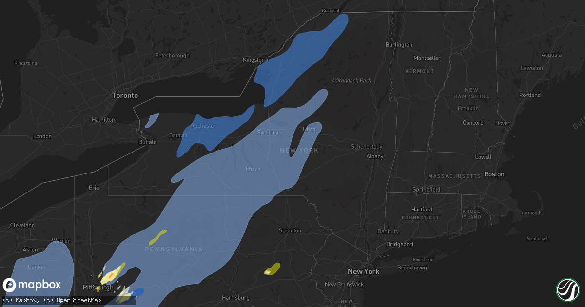
Hail Map in New York on March 16, 2025
Get this storm
March 16 map
$229
one time, instant access
Download today. No call, no setup
Keep the $229
Bought the map and want the full workflow? Apply the entire $229 to a subscription within 7 days. None of it is wasted.
Every map, not just this one
This buys you this map. Subscription and you get every map we run, in the markets you choose from a few cities to whole states to nationwide. Plus real-time alerts the moment a storm fires.
Contact data
Name, contact info, occupancy, even credit band for addresses in the footprint. You go from where it hit to who to call.
Become the source they trust
Unlimited branding weather history reports on demand. You already have the documented answer ready for the property owner, and you are the one who showed up with it.
Property data and RoofTrace estimates
Pull up any address you have got, its value and the exact code rules for that jurisdiction, straight from One Click Code. Then RoofTrace estimates the squares, pitch, and roof value, priced the way you price.
Storm reports in New York
New York
| Date | Description |
|---|---|
| 03/16/20256:09 PM CDT | Tree reported down near route 10 north of arietta. |
| 03/16/20256:08 PM CDT | Tree down on wires along higgins bay road near piseco. |
| 03/16/20255:59 PM CDT | Report of a couple of trees and wires down near hoffmeister... One of which occurring on french road. |
| 03/16/20255:03 PM CDT | Trees down throughout the county. |
| 03/16/20254:47 PM CDT | Trees and wires downed in the town of turin. |
| 03/16/20254:47 PM CDT | Numerous trees and wires downed across the town of port leyden. |
| 03/16/20254:46 PM CDT | Multiple trees down on gravel rd and grove st. |
| 03/16/20254:45 PM CDT | Patch of trees down in a straight lin |
| 03/16/20254:45 PM CDT | Patch of trees down in a straight line. |
| 03/16/20254:40 PM CDT | Trees and wires downed in the town of lowville. |
| 03/16/20254:36 PM CDT | Trees and wires downed in the town of antwerp. |
| 03/16/20254:33 PM CDT | Trees and wires downed in the town of champion. |
| 03/16/20254:28 PM CDT | A local report indicates 62 MPH wind near Fayetteville |
| 03/16/20254:27 PM CDT | A local report indicates 62 MPH wind near Addison |
| 03/16/20254:25 PM CDT | Roof of a barn lifted off. Time estimated from radar. |
| 03/16/20254:23 PM CDT | Trees and wires downed in the town of alexandria. |
| 03/16/20254:20 PM CDT | Trees and wires downed in the city of watertown. |
| 03/16/20254:18 PM CDT | Trees and wires downed in the town of brownville. |
| 03/16/20254:13 PM CDT | Trees and wires downed in the town of williamstown. |
| 03/16/20254:06 PM CDT | Trees and wires downed in the town of cleveland. |
| 03/16/20254:06 PM CDT | Trees and wires downed in the town of henderson. |
| 03/16/20254:06 PM CDT | Trees and wires downed in the town of constantia. |
| 03/16/20254:05 PM CDT | Mesonet station faye fayetteville. |
| 03/16/20254:04 PM CDT | An industrial building lost part of its roof. Time estimated to be at the same time as a 61 mph measured wind gust at ksyr asos since this location is very close to the |
| 03/16/20254:04 PM CDT | Asos station ksyr syracuse airport. |
| 03/16/20254:03 PM CDT | Trees and wires downed in the town of mexico. |
| 03/16/20254:02 PM CDT | Trees and wires downed in the town of west monroe. |
| 03/16/20254:00 PM CDT | Trees and wires downed in the town of hastings. |
| 03/16/20253:59 PM CDT | Trees and wires downed in the town of central square. |
| 03/16/20253:55 PM CDT | Numerous trees down on route 31 maple and mud mill road. |
| 03/16/20253:45 PM CDT | Numerous trees down. |
| 03/16/20253:45 PM CDT | Multiple trees and wires down in the area. |
| 03/16/20253:40 PM CDT | Multiple trees and wires down in the area. |
| 03/16/20253:40 PM CDT | Mesonet station grot groton. |
| 03/16/20253:40 PM CDT | A local report indicates 61 MPH wind near 1 NNE Groton |
| 03/16/20253:35 PM CDT | Mesonet station dvi12379 skaneateles. |
| 03/16/20253:35 PM CDT | Estimated winds along the line of storms 60-70 mph. |
| 03/16/20253:35 PM CDT | A local report indicates 72 MPH wind near Skaneateles |
| 03/16/20253:30 PM CDT | Mesonet station scip scipio center. |
| 03/16/20253:30 PM CDT | 10 to 12 trees down near hillendale golf course. |
| 03/16/20253:30 PM CDT | Time estimated from spotter. Numerous trees uprooted with some trees falling on sheds. Some docks on lamoka lake lifted up. |
| 03/16/20253:27 PM CDT | Multiple trees and wires down in the area. |
| 03/16/20253:22 PM CDT | Personal weather station recorded 59 mph winds... Several downed trees as well as damaged camper. Report passed along via social media. |
| 03/16/20253:14 PM CDT | Trees and wires downed in the town of arcadia. |
| 03/16/20253:13 PM CDT | Several trees and wires downed in the town of sodus. |
| 03/16/20253:11 PM CDT | Tree and limbs in roadway... Blocking only one lane of the road. Time estimated by radar. |
| 03/16/20253:11 PM CDT | Tree and limbs in roadway... Blocking only one lane of the road. Time estimated by radar. |
| 03/16/20253:08 PM CDT | A local report indicates 58 MPH wind near 1 ESE Elmira Arpt |
| 03/16/20253:08 PM CDT | A local report indicates 58 MPH wind near Elmira |
| 03/16/20253:08 PM CDT | Asos station kelm elmira airport. |
| 03/16/20253:06 PM CDT | Tree down across roadway. Time estimated by radar. |
| 03/16/20253:05 PM CDT | Trained spotter reported roof damage... And emergency manager reported barn roof torn off. |
| 03/16/20253:05 PM CDT | Numerous trees down... Mostly in the woods... But a couple of cars were also involved with trees on them. Radar-estimated time. |
| 03/16/20253:05 PM CDT | Damage to roof. |
| 03/16/20253:04 PM CDT | Tree downed on car on ridge road in williamson. |
| 03/16/20253:04 PM CDT | Numerous trees and wires downed in the town of williamson. |
| 03/16/20253:03 PM CDT | Large tree snapped in the middle. Another nearby large tree on a house. |
| 03/16/20253:03 PM CDT | Asos station kpeo penn yan. |
| 03/16/20253:00 PM CDT | Mesonet station tyro tyrone. |
| 03/16/20253:00 PM CDT | A local report indicates 62 MPH wind near Tyrone |
| 03/16/20253:00 PM CDT | Tree blocking roadway. Time estimated by radar. |
| 03/16/20252:57 PM CDT | Pole downed on car on route 441 in walworth. |
| 03/16/20252:57 PM CDT | Numerous trees and wires downed in the town of walworth. |
| 03/16/20252:56 PM CDT | Trees down... Car stuck. |
| 03/16/20252:55 PM CDT | Front porch and southside roof blown away from county line road residence. Radar-estimated time. |
| 03/16/20252:55 PM CDT | 2 trees fallen and partially blocking roadway. Time estimated by radar. |
| 03/16/20252:55 PM CDT | Tree across roadway. Time estimated by radar. |
| 03/16/20252:55 PM CDT | Trees down. Also a brush fire. |
| 03/16/20252:52 PM CDT | Tree down and wires down in roadway. Time estimated by radar. |
| 03/16/20252:52 PM CDT | Corrected time. |
| 03/16/20252:50 PM CDT | Corrects previous tstm wnd dmg report from 1 s tyrone. Time estimated from radar and other reports nearby. Numerous trees uprooted with some trees falling on sheds. Som |
| 03/16/20252:47 PM CDT | Trees down. |
| 03/16/20252:45 PM CDT | Roof of a building partially torn off. Time estimated from radar. |
| 03/16/20252:44 PM CDT | Tree across the roadway with wires down. Time estimated by radar. |
| 03/16/20252:44 PM CDT | Large tree down. Several trees down also. |
| 03/16/20252:38 PM CDT | Trees down. |
| 03/16/20252:35 PM CDT | Trees down. |
| 03/16/20252:35 PM CDT | Wires and tree down blocking roadway. Time estimated by radar. |
| 03/16/20252:30 PM CDT | Tree down blocking roadway. Time estimated by radar. |
| 03/16/20252:28 PM CDT | Multiple trees down. Tree down on residence. |
| 03/16/20252:25 PM CDT | Large tree limb down blocking both lanes of the roadway. Time estimated by radar. |
| 03/16/20252:25 PM CDT | Tree down on wires. Time estimated by radar. |
| 03/16/20252:20 PM CDT | Multiple reports of trees down. Time estimated by radar. |
| 03/16/20252:20 PM CDT | Measured wind gust at grove mesonet. |
| 03/16/20252:15 PM CDT | Tree down on wires. Time estimated by radar. |
| 03/16/20252:15 PM CDT | Multiple reports of trees down. Time estimated by radar. |
| 03/16/20252:08 PM CDT | Couple of building collapses on a farm. Unknown of the building types. Time estimated by radar. |
| 03/16/20252:06 PM CDT | Multiple reports of trees down. Time estimated by radar. |
| 03/16/20252:03 PM CDT | Multiple reports of trees down. Time estimated by radar. |
| 03/16/20252:03 PM CDT | Multiple reports of trees down. Time estimated by radar. |
| 03/16/20252:03 PM CDT | Multiple reports of trees down. Time estimated by radar. |
| 03/16/20251:58 PM CDT | Multiple reports of trees down. Time estimated by radar. |
| 03/16/20251:56 PM CDT | Multiple reports of trees down. Time estimated by radar. |
| 03/16/20251:52 PM CDT | Multiple reports of trees down. Time estimated by radar. |
| 03/16/20251:50 PM CDT | Multiple reports of trees down. Time estimated by radar. |
| 03/16/20251:39 PM CDT | Trees and wires downed in the town of wilson. |
| 03/16/20251:06 PM CDT | Multiple reports of trees down. Time estimated by radar. |
| 03/16/20251:02 PM CDT | Multiple reports of trees down. Time estimated by radar. |
| 03/16/202512:59 PM CDT | Multiple reports of trees down. Time estimated by radar. |
All States Impacted by Hail Map on March 16, 2025
Cities Impacted by Hail Map on March 16, 2025
- Fresno, OH
- Baltic, OH
- Stone Creek, OH
- Sugarcreek, OH
- New Philadelphia, OH
- South Williamson, KY
- Sidney, KY
- Belfry, KY
- Canada, KY
- Williamson, WV
- Delbarton, WV
- Forest Hills, KY
- Spencer, WV
- Creston, WV
- Reedy, WV
- Harrisville, WV
- Smithville, WV
- Macfarlan, WV
- Left Hand, WV
- Newton, WV
- Amma, WV
- Looneyville, WV
- Pennsboro, WV
- Pullman, WV
- Berea, WV
- Auburn, WV
- West Union, WV
- New Milton, WV
- Salem, WV
- Alma, WV
- Mount Clare, WV
- Clarksburg, WV
- Lost Creek, WV
- Meadowbrook, WV
- Hepzibah, WV
- Lumberport, WV
- Wallace, WV
- Bridgeport, WV
- Shinnston, WV
- Center Point, WV
- Spelter, WV
- Flemington, WV
- Fairmont, WV
- Grafton, WV
- Anmoore, WV
- Morgantown, WV
- Independence, WV
- Enterprise, WV
- Worthington, WV
- Navarre, OH
- Dalton, OH
- North Lawrence, OH
- Orrville, OH
- Canton, OH
- Canal Fulton, OH
- Massillon, OH
- Brewster, OH
- Clinton, OH
- Akron, OH
- Uniontown, OH
- North Canton, OH
- Hartville, OH
- Louisville, OH
- Middlebranch, OH
- Alliance, OH
- Arthurdale, WV
- Reedsville, WV
- Newburg, WV
- Masontown, WV
- Indianola, PA
- Cheswick, PA
- New Kensington, PA
- Pittsburgh, PA
- Oakmont, PA
- Harwick, PA
- Allison Park, PA
- Verona, PA
- Russellton, PA
- Tarentum, PA
- Gibsonia, PA
- Bakerstown, PA
- Glenshaw, PA
- Springdale, PA
- Creighton, PA
- Natrona Heights, PA
- Brackenridge, PA
- Sarver, PA
- Leechburg, PA
- Freeport, PA
- Vandergrift, PA
- Hyde Park, PA
- Kittanning, PA
- Ford City, PA
- Ford Cliff, PA
- McGrann, PA
- Templeton, PA
- Saxonburg, PA
- Valencia, PA
- Butler, PA
- Baden, PA
- McKees Rocks, PA
- Apollo, PA
- Manorville, PA
- Brunswick, GA
- Masontown, PA
- Garards Fort, PA
- Jefferson, PA
- Carmichaels, PA
- Rices Landing, PA
- Greensboro, PA
- Ronco, PA
- Nemacolin, PA
- Clarksville, PA
- Hopwood, PA
- New Salem, PA
- Dunbar, PA
- Oliver, PA
- Republic, PA
- Lemont Furnace, PA
- Brownsville, PA
- Crucible, PA
- Fairbank, PA
- Uledi, PA
- Smock, PA
- McClellandtown, PA
- Smithfield, PA
- Cardale, PA
- East Millsboro, PA
- Uniontown, PA
- Adah, PA
- Grindstone, PA
- Merrittstown, PA
- Mount Braddock, PA
- Allenport, PA
- West Newton, PA
- Alverton, PA
- Coal Center, PA
- Denbo, PA
- New Stanton, PA
- Elco, PA
- Perryopolis, PA
- Vanderbilt, PA
- Latrobe, PA
- Wyano, PA
- Fayette City, PA
- Dawson, PA
- Ruffs Dale, PA
- Millsboro, PA
- Tarrs, PA
- Hiller, PA
- Yukon, PA
- Bovard, PA
- Pleasant Unity, PA
- Hunker, PA
- California, PA
- Smithton, PA
- Scottdale, PA
- Vestaburg, PA
- Luxor, PA
- Roscoe, PA
- Youngwood, PA
- Stockdale, PA
- Dickerson Run, PA
- Connellsville, PA
- Everson, PA
- Allison, PA
- Wickhaven, PA
- La Belle, PA
- Newell, PA
- Star Junction, PA
- New Alexandria, PA
- Belle Vernon, PA
- Mount Pleasant, PA
- Fredericktown, PA
- Keisterville, PA
- Greensburg, PA
- Waltersburg, PA
- Daisytown, PA
- West Leisenring, PA
- Melcroft, PA
- Derry, PA
- Laughlintown, PA
- Somerset, PA
- Boswell, PA
- Jennerstown, PA
- Jones Mills, PA
- Rockwood, PA
- Loyalhanna, PA
- Youngstown, PA
- Stahlstown, PA
- Jenners, PA
- Friedens, PA
- Mill Run, PA
- Normalville, PA
- Central City, PA
- Acme, PA
- Shanksville, PA
- Hidden Valley, PA
- Bradenville, PA
- White, PA
- Hostetter, PA
- Champion, PA
- Indian Head, PA
- Stoystown, PA
- Quecreek, PA
- Gray, PA
- Rector, PA
- Ligonier, PA
- Acosta, PA
- Donegal, PA
- Westover, PA
- Nicktown, PA
- Davidsville, PA
- Patton, PA
- La Jose, PA
- Jerome, PA
- Robinson, PA
- Coral, PA
- Mineral Point, PA
- Cairnbrook, PA
- Armagh, PA
- Marsteller, PA
- Johnstown, PA
- Saint Benedict, PA
- South Fork, PA
- Brush Valley, PA
- Belsano, PA
- Spangler, PA
- Seward, PA
- Nanty Glo, PA
- Elmora, PA
- Twin Rocks, PA
- New Derry, PA
- Northern Cambria, PA
- New Florence, PA
- Saint Michael, PA
- Elton, PA
- Carrolltown, PA
- Windber, PA
- Hastings, PA
- Summerhill, PA
- Clymer, PA
- Ebensburg, PA
- Alverda, PA
- Homer City, PA
- Emeigh, PA
- Indiana, PA
- Penn Run, PA
- Dilltown, PA
- Parkhill, PA
- Josephine, PA
- Mentcle, PA
- Colver, PA
- Cherry Tree, PA
- Bolivar, PA
- Vintondale, PA
- Strongstown, PA
- Salix, PA
- Hollsopple, PA
- Heilwood, PA
- Sidman, PA
- Seanor, PA
- Blairsville, PA
- Black Lick, PA
- Hooversville, PA
- Loretto, PA
- Beaverdale, PA
- Portage, PA
- Saint Boniface, PA
- Lilly, PA
- Wilmore, PA
- Alum Bank, PA
- New Paris, PA
- Schellsburg, PA
- East Freedom, PA
- Duncansville, PA
- Queen, PA
- Cresson, PA
- Claysburg, PA
- Dysart, PA
- Chest Springs, PA
- Gallitzin, PA
- Ashville, PA
- Imler, PA
- Cassandra, PA
- Osterburg, PA
- Coalport, PA
- Rockton, PA
- Penfield, PA
- Flinton, PA
- Du Bois, PA
- Altoona, PA
- Mahaffey, PA
- Ridgway, PA
- Curwensville, PA
- Grampian, PA
- Kersey, PA
- Irvona, PA
- Brockport, PA
- Luthersburg, PA
- Johnsonburg, PA
- Commodore, PA
- Stump Creek, PA
- Starford, PA
- Reynoldsville, PA
- Glen Campbell, PA
- Big Run, PA
- Troutville, PA
- Arcadia, PA
- Rossiter, PA
- Brockway, PA
- Sykesville, PA
- Falls Creek, PA
- Burnside, PA
- Gipsy, PA
- Dixonville, PA
- Lucernemines, PA
- Rochester Mills, PA
- Hillsdale, PA
- Punxsutawney, PA
- Ernest, PA
- Marion Center, PA
- Saint Marys, PA
- Weedville, PA
- Benezett, PA
- Hollidaysburg, PA
- Newry, PA
- Williamsburg, PA
- Blandburg, PA
- Madera, PA
- Glen Hope, PA
- Tyrone, PA
- West Decatur, PA
- Tipton, PA
- Ramey, PA
- Clearfield, PA
- Roaring Spring, PA
- Philipsburg, PA
- Glen Richey, PA
- Fallentimber, PA
- New Millport, PA
- Hyde, PA
- Olanta, PA
- Houtzdale, PA
- Smithmill, PA
- Bellwood, PA
- Beccaria, PA
- Brisbin, PA
- Morrisdale, PA
- Osceola Mills, PA
- Frenchville, PA
- Wilcox, PA
- Byrnedale, PA
- Sandy Ridge, PA
- Wallaceton, PA
- Force, PA
- Bigler, PA
- Crosby, PA
- Smethport, PA
- Mineral Springs, PA
- Woodland, PA
- Driftwood, PA
- Emporium, PA
- Port Allegany, PA
- Huntingdon, PA
- Grassflat, PA
- Allport, PA
- Hawk Run, PA
- Alexandria, PA
- Pennsylvania Furnace, PA
- Warriors Mark, PA
- Spruce Creek, PA
- Munson, PA
- Kylertown, PA
- Winburne, PA
- Lanse, PA
- Port Matilda, PA
- Drifting, PA
- Petersburg, PA
- Karthaus, PA
- Pottersdale, PA
- Sinnamahoning, PA
- Roulette, PA
- Austin, PA
- Coudersport, PA
- Julian, PA
- Westport, PA
- Moshannon, PA
- Cadogan, PA
- Genesee, PA
- Clarence, PA
- Andover, NY
- Ulysses, PA
- Renovo, PA
- Snow Shoe, PA
- Wellsville, NY
- Galeton, PA
- Whitesville, NY
- Cross Fork, PA
- Mill Creek, PA
- Beech Creek, PA
- State College, PA
- Bellefonte, PA
- Lemont, PA
- University Park, PA
- Pine Grove Mills, PA
- Belleville, PA
- Fleming, PA
- Allensville, PA
- Orviston, PA
- McVeytown, PA
- Boalsburg, PA
- Centre Hall, PA
- Milesburg, PA
- Howard, PA
- Lewistown, PA
- Rexville, NY
- Troupsburg, NY
- Mills, PA
- Canisteo, NY
- North Bend, PA
- Lock Haven, PA
- Harrison Valley, PA
- Sabinsville, PA
- Reedsville, PA
- Westfield, PA
- Greenwood, NY
- Spring Mills, PA
- Gaines, PA
- Jasper, NY
- Mill Hall, PA
- Cammal, PA
- Cameron, NY
- Blanchard, PA
- Cedar Run, PA
- Milroy, PA
- Osceola, PA
- Cameron Mills, NY
- Waterville, PA
- Knoxville, PA
- Middlebury Center, PA
- Morris, PA
- Lamar, PA
- Slate Run, PA
- Jersey Mills, PA
- Wellsboro, PA
- Woodhull, NY
- Jersey Shore, PA
- Addison, NY
- Madisonburg, PA
- Rebersburg, PA
- Tioga, PA
- Bath, NY
- Lawrenceville, PA
- Elkland, PA
- Campbell, NY
- Avis, PA
- Coburn, PA
- Aaronsburg, PA
- Woodward, PA
- Trout Run, PA
- Millheim, PA
- Loganton, PA
- Townsend, GA
- Riceboro, GA
- Corning, NY
- Burdett, NY
- Millport, NY
- Montour Falls, NY
- Beaver Dams, NY
- Watkins Glen, NY
- Nelson, PA
- Savona, NY
- Pine City, NY
- Mansfield, PA
- Odessa, NY
- Horseheads, NY
- Bradford, NY
- Big Flats, NY
- Lindley, NY
- Painted Post, NY
- Covington, PA
- Milan, PA
- Shunk, PA
- Roaring Branch, PA
- Alba, PA
- Elmira, NY
- Blossburg, PA
- Cogan Station, PA
- Linden, PA
- Alpine, NY
- Chemung, NY
- Sayre, PA
- Troy, PA
- Erin, NY
- Cayuta, NY
- Granville Summit, PA
- Columbia Cross Roads, PA
- Breesport, NY
- Williamsport, PA
- Wellsburg, NY
- Liberty, PA
- Morris Run, PA
- Canton, PA
- Gillett, PA
- Mainesburg, PA
- Millerton, PA
- Ralston, PA
- Towanda, PA
- Ulster, PA
- East Smithfield, PA
- Athens, PA
- Pine Valley, NY
- Lowman, NY
- Winfield, PA
- McAlisterville, PA
- Laporte, PA
- Shamokin Dam, PA
- White Deer, PA
- Sunbury, PA
- Middleburg, PA
- Montoursville, PA
- Lewisburg, PA
- Muncy Valley, PA
- Watsontown, PA
- Catawissa, PA
- Montandon, PA
- Millmont, PA
- Lairdsville, PA
- Hughesville, PA
- Burnham, PA
- Milton, PA
- Monroeton, PA
- New Columbia, PA
- Mildred, PA
- Hillsgrove, PA
- Nescopeck, PA
- Mifflinville, PA
- Yeagertown, PA
- New Berlin, PA
- Montgomery, PA
- Turbotville, PA
- Laurelton, PA
- West Milton, PA
- Sweet Valley, PA
- Riverside, PA
- Shickshinny, PA
- Beavertown, PA
- Dushore, PA
- Lopez, PA
- Muncy, PA
- McClure, PA
- Millville, PA
- Bloomsburg, PA
- Orangeville, PA
- Berwick, PA
- Northumberland, PA
- Mifflinburg, PA
- Benton, PA
- Beaver Springs, PA
- Eagles Mere, PA
- Forksville, PA
- Selinsgrove, PA
- Stillwater, PA
- Allenwood, PA
- McEwensville, PA
- New Albany, PA
- Huntington Mills, PA
- Danville, PA
- Unityville, PA
- Mifflintown, PA
- Port Trevorton, PA
- Lockwood, NY
- Mount Carmel, PA
- Zion Grove, PA
- Granville, PA
- Le Raysville, PA
- Sugarloaf, PA
- Spencer, NY
- Mount Pleasant Mills, PA
- Dornsife, PA
- Trevorton, PA
- Thompsontown, PA
- Marion Heights, PA
- Waverly, NY
- Elysburg, PA
- Barton, NY
- Millerstown, PA
- Nichols, NY
- Rebuck, PA
- Shamokin, PA
- Herndon, PA
- Liverpool, PA
- Rome, PA
- Coal Township, PA
- Paxinos, PA
- Cocolamus, PA
- Hunlock Creek, PA
- Richfield, PA
- Mehoopany, PA
- Kulpmont, PA
- Wyalusing, PA
- Klingerstown, PA
- Locust Gap, PA
- Wysox, PA
- Sugar Run, PA
- Leck Kill, PA
- Laceyville, PA
- Oakland Mills, PA
- Stevensville, PA
- Newfield, NY
- Van Etten, NY
- Freeburg, PA
- Wilburton, PA
- Delmont, PA
- Saltsburg, PA
- Export, PA
- Slickville, PA
- Jeannette, PA
- Claridge, PA
- Locke, NY
- Moravia, NY
- Lansing, NY
- Groton, NY
- Auburn, NY
- Syracuse, NY
- Genoa, NY
- Scipio Center, NY
- Trumansburg, NY
- Marcellus, NY
- Skaneateles, NY
- Ithaca, NY
- Marietta, NY
- Camillus, NY
- King Ferry, NY
- Interlaken, NY
- Aurora, NY
- Ovid, NY
- Lodi, NY
- Hector, NY
- Rock Stream, NY
- Owego, NY
- Freeville, NY
- Homer, NY
- Dryden, NY
- Preble, NY
- Brooktondale, NY
- Cortland, NY
- Willseyville, NY
- Candor, NY
- Slaterville Springs, NY
- Nedrow, NY
- Liverpool, NY
- Berkshire, NY
- Jamesville, NY
- La Fayette, NY
- Tully, NY
- East Syracuse, NY
- Newark Valley, NY
- Apalachin, NY
- Endicott, NY
- Maine, NY
- Lisle, NY
- Fayetteville, NY
- Glen Aubrey, NY
- Apulia Station, NY
- Richford, NY
- Cincinnatus, NY
- Marathon, NY
- Whitney Point, NY
- Fabius, NY
- Harford, NY
- Truxton, NY
- McGraw, NY
- Little York, NY
- Little Meadows, PA
- Warren Center, PA
- Kirkville, NY
- New Woodstock, NY
- Manlius, NY
- Minoa, NY
- Johnson City, NY
- Willet, NY
- Smithville Flats, NY
- Binghamton, NY
- Vestal, NY
- Pitcher, NY
- De Ruyter, NY
- Castle Creek, NY
- Cicero, NY
- Cleveland, NY
- Williamstown, NY
- Constantia, NY
- Bridgeport, NY
- Chittenango, NY
- Cazenovia, NY
- Camden, NY
- Bernhards Bay, NY
- Brackney, PA
- Three Mile Bay, NY
- Mexico, NY
- Clayton, NY
- Cape Vincent, NY
- Henderson Harbor, NY
- Pulaski, NY
- Henderson, NY
- Sandy Creek, NY
- Richland, NY
- Belleville, NY
- Altmar, NY
- Chaumont, NY
- Dexter, NY
- Adams Center, NY
- Mannsville, NY
- Ellisburg, NY
- Lacona, NY
- Sackets Harbor, NY
- Adams, NY
- Calcium, NY
- Watertown, NY
- Lorraine, NY
- La Fargeville, NY
- Theresa, NY
- Alexandria Bay, NY
- Plessis, NY
- Redwood, NY
- Depauville, NY
- Rodman, NY
- Brownville, NY
- Evans Mills, NY
- Friendsville, PA
- Canastota, NY
- Westdale, NY
- Taberg, NY
- North Bay, NY
- Blossvale, NY
- Georgetown, NY
- Munnsville, NY
- Smyrna, NY
- Hamilton, NY
- Verona, NY
- Greene, NY
- Chenango Forks, NY
- Oxford, NY
- Plymouth, NY
- North Pitcher, NY
- Morrisville, NY
- Sylvan Beach, NY
- Oneida, NY
- South Otselic, NY
- Earlville, NY
- Rome, NY
- South Plymouth, NY
- Sherrill, NY
- Vernon, NY
- Wampsville, NY
- Norwich, NY
- Verona Beach, NY
- Durhamville, NY
- McDonough, NY
- Eaton, NY
- Port Crane, NY
- Vernon Center, NY
- Bouckville, NY
- Erieville, NY
- Lee Center, NY
- West Leyden, NY
- Ava, NY
- Boonville, NY
- Westernville, NY
- Oriskany, NY
- Holland Patent, NY
- Philadelphia, NY
- Black River, NY
- Copenhagen, NY
- Fort Drum, NY
- Redfield, NY
- Felts Mills, NY
- Carthage, NY
- Lowville, NY
- Ogdensburg, NY
- De Peyster, NY
- Heuvelton, NY
- Hammond, NY
- Antwerp, NY
- Gouverneur, NY
- Natural Bridge, NY
- Brohard, WV
- Middlebourne, WV
- Holden, WV
- Conklin, NY
- Kirkwood, NY
- Windsor, NY
- Harpursville, NY
- Afton, NY
- Bainbridge, NY
- Waterville, NY
- Sherburne, NY
- Madison, NY
- Hubbardsville, NY
- Remsen, NY
- Alder Creek, NY
- Cold Brook, NY
- Forestport, NY
- Woodgate, NY
- Eagle Bay, NY
- Old Forge, NY
- Thendara, NY
- Port Leyden, NY
- Oswegatchie, NY
- Wanakena, NY
- Harrisville, NY
- Rensselaer Falls, NY
- Fine, NY
- Russell, NY
- Richville, NY
- Croghan, NY
- Edwards, NY
- Hermon, NY
- De Kalb Junction, NY
- Colton, NY
- Norwood, NY
- Lisbon, NY
- Canton, NY
- Potsdam, NY
- Mathias, WV
- Bergton, VA
- Brandywine, WV
- Sugar Grove, WV
- Lancaster, SC
- Pageland, SC
- Basye, VA
- Hinton, VA
- Fulks Run, VA
- Milam, WV
- Criders, VA
- Broadway, VA
- Mount Jackson, VA
- Edinburg, VA
- Orkney Springs, VA
- Timberville, VA
- Quicksburg, VA
- Wardensville, WV
- Woodstock, VA
- Marshville, NC
- Edmeston, NY
- Morris, NY
- Otego, NY
- West Edmeston, NY
- Brookfield, NY
- North Brookfield, NY
- Garrattsville, NY
- Mount Upton, NY
- Guilford, NY
- Unadilla, NY
- Gilbertsville, NY
- New Berlin, NY
- South New Berlin, NY
- Laurens, NY
- New Lisbon, NY
- Nineveh, NY
- Mount Vision, NY
- West Winfield, NY
- Leonardsville, NY
- Clinton, NY
- Deansboro, NY
- New York Mills, NY
- Chadwicks, NY
- Marcy, NY
- Bridgewater, NY
- Clayville, NY
- Sauquoit, NY
- Utica, NY
- Yorkville, NY
- Cassville, NY
- New Hartford, NY
- Whitesboro, NY
- West Burlington, NY
- Burlington Flats, NY
- Poland, NY
- Herkimer, NY
- Ilion, NY
- Frankfort, NY
- Barneveld, NY
- Richfield Springs, NY
- Hartwick, NY
- Newport, NY
- Little Falls, NY
- Middleville, NY
- Winthrop, NY
- Saint Regis Falls, NY
- Parishville, NY
- Newton Falls, NY
- South Colton, NY
- Nicholville, NY
- Moira, NY
- North Lawrence, NY
- Brasher Falls, NY
- Bombay, NY
- Dickinson Center, NY
- Brushton, NY
- Fort Covington, NY
- Maurertown, VA
- Ridgeway, SC
- Winnsboro, SC
- Polkton, NC
- Cross Junction, VA
- Bloomery, WV
- Capon Bridge, WV
- Wadesboro, NC
- Great Falls, SC
- Peachland, NC
- Constable, NY
- Malone, NY
- North Bangor, NY
- Trinity, NC
- Sophia, NC
- Thomasville, NC
- Asheboro, NC
- Denton, NC
- Lexington, NC
- High Point, NC
- Greensboro, NC
- Randleman, NC
- Jamestown, NC
- Browns Summit, NC
- High View, WV
- Waynesboro, PA
- Quincy, PA
- Danville, VA
- Middletown, VA
- Reidsville, NC
- Winchester, VA
- Stephens City, VA
- Strasburg, VA
- Chatham, VA
- Dry Fork, VA
- Berryville, VA
- Boyce, VA
- Front Royal, VA
- White Post, VA
- Stephenson, VA
- Summit Point, WV
- Charles Town, WV
- Harpers Ferry, WV
- Millville, WV
- Knoxville, MD
- Lovettsville, VA
- Purcellville, VA
- Rohrersville, MD
- Brownsville, MD
- Brunswick, MD
- Jefferson, MD
- Burkittsville, MD
- Middletown, MD
- Myersville, MD
- Frederick, MD
- Braddock Heights, MD
- Thurmont, MD
- Walkersville, MD
- Woodsboro, MD
- Linden, VA
- Pottsville, PA
- Saint Clair, PA
- Port Carbon, PA
- Sharpsburg, MD
- Ranson, WV
- Rocky Ridge, MD
- Keymar, MD
- Emmitsburg, MD
- Taneytown, MD
- Union Bridge, MD
- Mar Lin, PA
- Seltzer, PA
- Schuylkill Haven, PA
- Orwigsburg, PA
- New Philadelphia, PA
- Cumbola, PA
- Tamaqua, PA
- New Ringgold, PA
- Middleport, PA
- Barnesville, PA
- Mary D, PA
- Brockton, PA
- Tuscarora, PA
- Coaldale, PA
- Nesquehoning, PA
- Lansford, PA
- Littlestown, PA
- Westminster, MD
- Hanover, PA
- Paris, VA
- Manchester, MD
- Julian, NC
- Climax, NC
- Spring Grove, PA
- Abbottstown, PA
- Thomasville, PA
- Glen Rock, PA
- Glenville, PA
- Seven Valleys, PA
- York, PA
- York New Salem, PA
- Dover, PA
- Dallastown, PA
- Manchester, PA
- Mount Wolf, PA
- Emigsville, PA
- Red Lion, PA
- Marietta, PA
- Wrightsville, PA
- Windsor, PA
- Mount Joy, PA
- Columbia, PA
- Washington Boro, PA
- Bairdford, PA
- Cabot, PA
- Fenelton, PA
- Chicora, PA
- Worthington, PA
- East Brady, PA
- Cowansville, PA
- Karns City, PA
- Parker, PA
- Rimersburg, PA
- East Vandergrift, PA
- North Apollo, PA
- Spring Church, PA
- Adrian, PA
- Clarion, PA
- New Bethlehem, PA
- Shippenville, PA
- Knox, PA
- Sligo, PA
- Rural Valley, PA
- Shelocta, PA
- Yatesboro, PA
- Brookville, PA
- Clarington, PA
- Strattanville, PA
- Marienville, PA
- Vowinckel, PA
- Cooksburg, PA
- Leeper, PA
- Sigel, PA
- Fairmount City, PA
- Summerville, PA
- Mayport, PA
- Corsica, PA
- Dayton, PA
- Ringgold, PA
- Timblin, PA
- Seminole, PA
- Worthville, PA
- Hawthorn, PA
- Coolspring, PA
- Knox Dale, PA
- Murrysville, PA
- Sprankle Mills, PA
- Smicksburg, PA
- Creekside, PA
- Northpoint, PA
- Oliveburg, PA
- Sagamore, PA
- Hamilton, PA
- Home, PA
- Walston, PA
- De Lancey, PA
- Anita, PA
- Valier, PA
- Le Roy, NY
- Bergen, NY
- Byron, NY
- Stafford, NY
- East Bethany, NY
- Piffard, NY
- Pavilion, NY
- Linwood, NY
- Brockport, NY
- Churchville, NY
- Caledonia, NY
- Spencerport, NY
- Mumford, NY
- Hilton, NY
- Scottsville, NY
- North Chili, NY
- Rochester, NY
- Rush, NY
- Avon, NY
- West Henrietta, NY
- Henrietta, NY
- Lima, NY
- Honeoye Falls, NY
- York, NY
- Geneseo, NY
- Livonia, NY
- Bloomfield, NY
- Hemlock, NY
- Honeoye, NY
- Mendon, NY
- Farmington, NY
- Pittsford, NY
- Fairport, NY
- East Rochester, NY
- Victor, NY
- Canandaigua, NY
- West Bloomfield, NY
- Ionia, NY
- Macedon, NY
- Palmyra, NY
- Lyons, NY
- Marion, NY
- Webster, NY
- Clifton Springs, NY
- Penfield, NY
- Phelps, NY
- Manchester, NY
- Newark, NY
- Walworth, NY
- Shortsville, NY
- Ontario, NY
- Wolcott, NY
- Sodus Point, NY
- Savannah, NY
- Williamson, NY
- Red Creek, NY
- North Rose, NY
- Clyde, NY
- Sodus, NY
- Hannibal, NY
- Sterling, NY
- Oswego, NY
- Martville, NY
- Warsaw, NY
- Bliss, NY
- Silver Springs, NY
- Wyoming, NY
- Perry, NY
- Gainesville, NY
- South Byron, NY
- Leicester, NY
- Retsof, NY
- Rockbridge, OH
- McArthur, OH
- South Bloomingville, OH
- Laurelville, OH
- Logan, OH
- Thornville, OH
- Somerset, OH
- Bremen, OH
- Junction City, OH
- Hopewell, OH
- Sugar Grove, OH
- Mount Perry, OH
- Lancaster, OH
- Heath, OH
- Glenford, OH
- Rushville, OH
- New Lexington, OH
- Jacksonville, OH
- Nelsonville, OH
- New Plymouth, OH
- Crooksville, OH
- Haydenville, OH
- Murray City, OH
- Glouster, OH
- Creola, OH
- Amesville, OH
- Chauncey, OH
- Buchtel, OH
- Athens, OH
- New Straitsville, OH
- Union Furnace, OH
- Corning, OH
- Millfield, OH
- Roseville, OH
- New Marshfield, OH
- Shawnee, OH
- The Plains, OH
- Trimble, OH
- Londonderry, OH
- White Cottage, OH
- Warsaw, OH
- Frazeysburg, OH
- Malta, OH
- Coshocton, OH
- Dresden, OH
- Nashport, OH
- Zanesville, OH
- Blue Rock, OH
- Conesville, OH
- Trinway, OH
- Mcconnelsville, OH
- Blissfield, OH
- Millersburg, OH
- Killbuck, OH
- Holmesville, OH
- Fredericksburg, OH
- Philo, OH
- Shreve, OH
- Wooster, OH
- Smithville, OH
- Apple Creek, OH
- Sterling, OH
- Marshallville, OH
- Chesterhill, OH
- Adamsville, OH
- Rittman, OH
- Norwich, OH
- Dundee, OH
- Strasburg, OH
- Mount Eaton, OH
- Duncan Falls, OH
- Chandlersville, OH
- Wilmot, OH
- New Concord, OH
- Doylestown, OH
- Beach City, OH
- West Lafayette, OH
- Cambridge, OH
- Mineral City, OH
- Magnolia, OH
- Zoar, OH
- Port Washington, OH
- Mogadore, OH
- Bolivar, OH
- Newcomerstown, OH
- East Canton, OH
- Stockport, OH
- Kimbolton, OH
- Sandyville, OH
- Atwater, OH
- East Sparta, OH
- Plainfield, OH
- Dover, OH
- Deerfield, OH
- Gnadenhutten, OH
- Paris, OH
- Limaville, OH
- Waynesburg, OH
- North Benton, OH
- Somerdale, OH
- Kensington, OH
- Byesville, OH
- Beverly, OH
- Bethesda, OH
- Carrollton, OH
- Belmont, OH
- Salesville, OH
- Sebring, OH
- Pleasant City, OH
- Homeworth, OH
- Lore City, OH
- Robertsville, OH
- Senecaville, OH
- Mechanicstown, OH
- Morristown, OH
- Old Washington, OH
- Flushing, OH
- Cumberland, OH
- Scio, OH
- Beloit, OH
- Quaker City, OH
- Saint Clairsville, OH
- Sarahsville, OH
- Jewett, OH
- Freeport, OH
- Dennison, OH
- Minerva, OH
- Tippecanoe, OH
- Barnesville, OH
- Summerfield, OH
- Midvale, OH
- Uhrichsville, OH
- East Rochester, OH
- Kipling, OH
- Belle Valley, OH
- Piedmont, OH
- Tuscarawas, OH
- Cadiz, OH
- Dellroy, OH
- Sherrodsville, OH
- Malvern, OH
- Bowerston, OH
- Caldwell, OH
- Amsterdam, OH
- Leesville, OH
- Hopedale, OH
- Bergholz, OH
- Mount Pleasant, OH
- Bloomingdale, OH
- Richmond, OH
- Rayland, OH
- Salem, OH
- Smithfield, OH
- Salineville, OH
- Dillonvale, OH
- East Springfield, OH
- Bridgeport, OH
- Lewisville, OH
- Hanoverton, OH
- Adena, OH
- Waterford, OH
- Rootstown, OH
- Ravenna, OH
- Diamond, OH
- Leavittsburg, OH
- Berlin Center, OH
- Lisbon, OH
- Newton Falls, OH
- Irondale, OH
- Summitville, OH
- North Jackson, OH
- Lake Milton, OH
- Canfield, OH
- Damascus, OH
- Warren, OH
- Hammondsville, OH
- North Lima, OH
- Niles, OH
- Wellsville, OH
- Washingtonville, OH
- Youngstown, OH
- Leetonia, OH
- Girard, OH
- Steubenville, OH
- Toronto, OH
- Mineral Ridge, OH
- Columbiana, OH
- Mingo Junction, OH
- McDonald, OH
- New Waterford, OH
- New Springfield, OH
- East Palestine, OH
- Newell, WV
- East Liverpool, OH
- Rogers, OH
- New Cumberland, WV
- Negley, OH
- Petersburg, OH
- Stratton, OH
- Empire, OH
- Chester, WV
- Weirton, WV
- New Manchester, WV
- Big Springs, WV
- Mount Zion, WV
- Glenville, WV
- Troy, WV
- Grantsville, WV
- Arnoldsburg, WV
- Coxs Mills, WV
- Alum Bridge, WV
- Big Bend, WV
- Elizabeth, WV
- Munday, WV
- Palestine, WV
- Millstone, WV
- Normantown, WV
- Camden, WV
- Orma, WV
- Porters Falls, WV
- Reader, WV
- Paden City, WV
- New Martinsville, WV
- Sistersville, WV
- Smithfield, WV
- Jacksonburg, WV
- Folsom, WV
- Pine Grove, WV
- Sardis, OH
- Ellenboro, WV
- Friendly, WV
- Petroleum, WV
- Saint Marys, WV
- Cairo, WV
- Mannington, WV
- Littleton, WV
- West Finley, PA
- Hundred, WV
- Powhatan Point, OH
- Clarington, OH
- Glen Easton, WV
- Dallas, WV
- Hannibal, OH
- New Matamoras, OH
- Aleppo, PA
- Proctor, WV
- Metz, WV
- Wind Ridge, PA
- New Freeport, PA
- Cameron, WV
- Wheeling, WV
- Moundsville, WV
- Burton, WV
- Claysville, PA
- Holbrook, PA
- West Alexander, PA
- Graysville, PA
- Waynesburg, PA
- Montana Mines, WV
- Pursglove, WV
- Farmington, WV
- Blacksville, WV
- Baxter, WV
- Maidsville, WV
- Carolina, WV
- Barrackville, WV
- Rivesville, WV
- Fairview, WV
- Spraggs, PA
- Mount Morris, PA
- Wana, WV
- Rachel, WV
- Brave, PA
- Osage, WV
- Granville, WV
- Dilliner, PA
- Lake Lynn, PA
- Bobtown, PA
- Point Marion, PA
- Prosperity, PA
- Scenery Hill, PA
- Beallsville, PA
- Marianna, PA
- Sycamore, PA
- Richeyville, PA
- Amity, PA
- Charleroi, PA
- Mather, PA
- Rogersville, PA
- New Geneva, PA
- Fairchance, PA
- Martin, PA
- Brownfield, PA
- Jane Lew, WV
- West Milford, WV
- Farmington, PA
- Bruceton Mills, WV
- Bretz, WV
- Triadelphia, WV
- Atlantic Beach, NC
- Morehead City, NC
- Beaufort, NC
- Davis, NC
- Smyrna, NC
- Stacy, NC
- Marshallberg, NC
- Gloucester, NC
- Harkers Island, NC
- Hertford, NC
- Elizabeth City, NC
- West Palm Beach, FL
- Pembroke, VA
- Staffordsville, VA
- Pearisburg, VA
- Blacksburg, VA
- Folkston, GA
- Rocky Point, NC
- Burgaw, NC
- Pulaski, VA
- Dublin, VA
- Bland, VA
- East Amherst, NY
- Buffalo, NY
- Sanborn, NY
- Newfane, NY
- North Tonawanda, NY
- Lockport, NY
- Wilson, NY
- Ransomville, NY
- Burt, NY
- Appleton, NY
- Barker, NY
- Olcott, NY
- Mount Jewett, PA
- Bolivar, NY
- Portville, NY
- Shinglehouse, PA
- Little Genesee, NY
- Turtlepoint, PA
- Ceres, NY
- Eldred, PA
- Scio, NY
- Allentown, NY
- Friendship, NY
- Alma, NY
- Belfast, NY
- Angelica, NY
- Cuba, NY
- Belmont, NY
- Almond, NY
- Caneadea, NY
- Black Creek, NY
- Fillmore, NY
- Alfred Station, NY
- Hornell, NY
- Alfred, NY
- Cohocton, NY
- Canaseraga, NY
- Avoca, NY
- Conesus, NY
- Springwater, NY
- Arkport, NY
- Hunt, NY
- Dalton, NY
- Swain, NY
- Wayland, NY
- Dansville, NY
- Houghton, NY
- Nunda, NY
- Prattsburgh, NY
- Rushville, NY
- Bellona, NY
- Atlanta, NY
- Stanley, NY
- Keuka Park, NY
- Branchport, NY
- Geneva, NY
- Pulteney, NY
- Middlesex, NY
- Penn Yan, NY
- Hammondsport, NY
- Dundee, NY
- Hall, NY
- Naples, NY
- Himrod, NY
- Dresden, NY
- Waterloo, NY
- Fayette, NY
- Seneca Falls, NY
- Union Springs, NY
- Romulus, NY
- Port Byron, NY
- Cayuga, NY
- Skaneateles Falls, NY
- Baldwinsville, NY
- Memphis, NY
- Jordan, NY
- Warners, NY
- Weedsport, NY
- Elbridge, NY
- Central Square, NY
- Phoenix, NY
- Brewerton, NY
- Clay, NY
- Pennellville, NY
- West Monroe, NY
- Nineveh, PA
- Lowber, PA
- Sutersville, PA
- Dunlevy, PA
- Donora, PA
- Irwin, PA
- Buena Vista, PA
- Webster, PA
- Herminie, PA
- Elizabeth, PA
- Monongahela, PA
- Monessen, PA
- Eighty Four, PA
- Van Voorhis, PA
- Cokeburg, PA
- New Eagle, PA
- Ellsworth, PA
- Finleyville, PA
- Bentleyville, PA
- Washington, PA
- Trafford, PA
- Forbes Road, PA
- Hannastown, PA
- Westmoreland City, PA
- Larimer, PA
- Manor, PA
- Mckeesport, PA
- Harrison City, PA
- Penn, PA
- Adamsburg, PA
- Arona, PA
- Madison, PA
- Rillton, PA
- Grapeville, PA
- Crabtree, PA
- Darragh, PA
- Avonmore, PA
- Clarksburg, PA
- Venetia, PA
- Homestead, PA
- Canonsburg, PA
- Houston, PA
- Bethel Park, PA
- Lawrence, PA
- Meadow Lands, PA
- Bridgeville, PA
- Muse, PA
- Strabane, PA
- Carnegie, PA
- West Mifflin, PA
- Braddock, PA
- South Park, PA
- Clairton, PA
- Presto, PA
- Gandeeville, WV
- Procious, WV
- Walton, WV
- Clendenin, WV
- Elkview, WV
- Bomont, WV
- Duck, WV
- Wallback, WV
- Rosedale, WV
- Nebo, WV
- Ivydale, WV
- Clay, WV
- Maysel, WV
- Chloe, WV
- Exchange, WV
- Frametown, WV
- Flatwoods, WV
- Copen, WV
- Cedarville, WV
- Gassaway, WV
- Burnsville, WV
- Shock, WV
- Horner, WV
- Orlando, WV
- Weston, WV
- Sand Fork, WV
- Linn, WV
- Walkersville, WV
- Volga, WV
- Philippi, WV
- Buckhannon, WV
- Thornton, WV
- Advent, WV
- Red House, WV
- Poca, WV
- Gay, WV
- Leon, WV
- Charleston, WV
- Buffalo, WV
- Ripley, WV
- Liberty, WV
- Kenna, WV
- Given, WV
- Le Roy, WV


