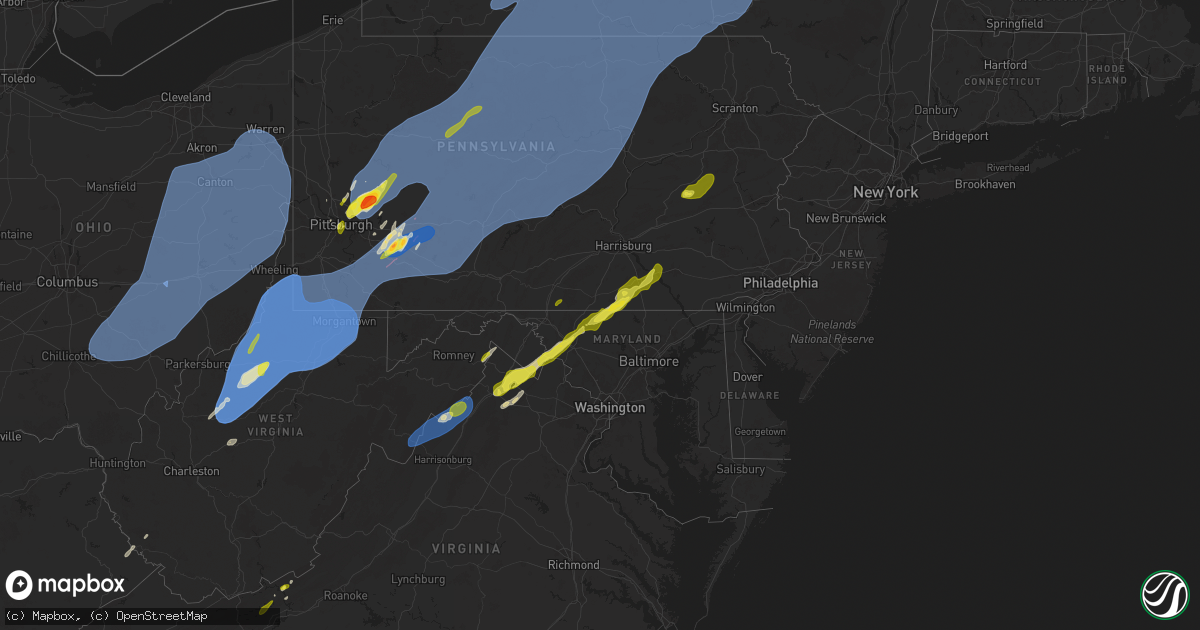
Hail Map on March 16, 2025
Get this storm
March 16 map
$229
one time, instant access
Download today. No call, no setup
Keep the $229
Bought the map and want the full workflow? Apply the entire $229 to a subscription within 7 days. None of it is wasted.
Every map, not just this one
This buys you this map. Subscription and you get every map we run, in the markets you choose from a few cities to whole states to nationwide. Plus real-time alerts the moment a storm fires.
Contact data
Name, contact info, occupancy, even credit band for addresses in the footprint. You go from where it hit to who to call.
Become the source they trust
Unlimited branding weather history reports on demand. You already have the documented answer ready for the property owner, and you are the one who showed up with it.
Property data and RoofTrace estimates
Pull up any address you have got, its value and the exact code rules for that jurisdiction, straight from One Click Code. Then RoofTrace estimates the squares, pitch, and roof value, priced the way you price.
States Impacted by Hail Map on March 16, 2025
Storm reports
Virginia
| Date | Description |
|---|---|
| 03/16/20255:29 PM CDT | Tree down at the intersection of quicksburg rd and boiling springs lane |
| 03/16/20255:26 PM CDT | Shingles blown off of a house at the 1200 block of senedo rd in mt jackson. |
| 03/16/20254:22 PM CDT | Biggest hail stone half dollar. Most nickel to quarter. 5:22 to 5:26 pm. |
| 03/16/20254:12 PM CDT | Damage to window and siding. |
| 03/16/20253:21 PM CDT | Corrects previous tstm wnd dmg report from 3 sw dublin. Damage to window and siding. |
| 03/16/20259:48 AM CDT | Several trees reported down near the community of prater near dickenson highway. |
| 03/16/202512:08 AM CDT | Dominion reports damaged power lines at windmill point rd. |
| 03/15/202511:44 PM CDT | A tree fell along the road. |
| 03/15/202511:40 PM CDT | Dominion reports damaged power lines at pebble beach ln. |
| 03/15/20257:52 PM CDT | 5 trees downed in various locations along mount torrey rd and signal ln. |
| 03/15/20257:25 PM CDT | A local report indicates 1.00 inch wind near Berryville |
Georgia
| Date | Description |
|---|---|
| 03/16/202510:42 AM CDT | Mcintosh county emergency management reported several trees fell across the tolomato causeway. Time estimated based on radar. |
| 03/16/202510:42 AM CDT | Mcintosh county emergency management several trees snapped along misson drive. Two homes were also damaged by fallen trees. Time was estimated based on radar. |
| 03/16/202510:06 AM CDT | Downed trees were reported along riverside rd near thrift loop and stephen park rd. A few were reported to have fallen on powerlines. Time estimated by radar. |
| 03/16/20259:55 AM CDT | 2 homes has minor to moderate damage with some shingles peeled from roof. Shed turned upside down. Trees knocked down near samuel crews road. Trees knocked down on char |
| 03/16/20259:55 AM CDT | Corrects previous tstm wnd dmg report from winokur. 2 homes has minor to moderate damage with some shingles peeled from roof. Shed turned upside down. Trees knocked dow |
| 03/16/20258:02 AM CDT | Ham radio operator reports power lines down and outage to 1200 homes near intersection of clito road and five chop road. |
| 03/16/20257:24 AM CDT | Tree reported down on hwy 125 and van wheless rd. |
Kentucky
| Date | Description |
|---|---|
| 03/16/20257:50 AM CDT | Tree down on 400 block of sulphur wells rd. |
| 03/16/20257:47 AM CDT | Tree down on towson rd in georgetown. |
Pennsylvania
| Date | Description |
|---|---|
| 03/16/20255:56 PM CDT | Tree down on alborn avenue. Time estimated. |
| 03/16/20255:45 PM CDT | Tree down near intersection of enon road and pennsylvania turnpike. Time estimated. |
| 03/16/20254:29 PM CDT | Tree down on cook road. |
| 03/16/20253:37 PM CDT | A few trees down in northern portions of the county. |
| 03/16/20253:30 PM CDT | Corrects previous tstm wnd dmg report from franklindale. Tree down on cook road. |
| 03/16/20253:14 PM CDT | Corrects previous tstm wnd dmg report from clearfield. Nws employee reports straight line wind damage... 50 trees down near rolling stone road. |
| 03/16/20252:54 PM CDT | Trees down. |
| 03/16/20252:46 PM CDT | Roof blown off of a garage/outbuilding. |
| 03/16/20252:46 PM CDT | Multiple trees and wires down in mansfield. |
| 03/16/20252:42 PM CDT | Measured 63 mph wind gust in larryville. |
| 03/16/20252:38 PM CDT | Roof damage at a drivers license center in yeagertown. |
| 03/16/20252:30 PM CDT | Awos station lhv9 lock haven airport. |
| 03/16/20252:30 PM CDT | Numerous trees down on the north side of beech creek. |
| 03/16/20252:27 PM CDT | Large tree down and power outage in state college borough |
| 03/16/20252:23 PM CDT | Trees and wires down/power outage at 1408 atherton st in ferguson township. |
| 03/16/20252:22 PM CDT | Corrects time |
| 03/16/20252:22 PM CDT | Trees and wires down. |
| 03/16/20252:21 PM CDT | Half dozen trees down in strong thunderstorm winds. |
| 03/16/20252:14 PM CDT | Trees down and pea sized hail on purdue mountain road. |
| 03/16/20252:10 PM CDT | Multiple trees down on axemann rd. |
| 03/16/20252:08 PM CDT | Corrects time previous tstm wnd dmg report from bedford... Damage time-matched to radar. Trees down. |
| 03/16/20252:07 PM CDT | Trees and wires down... Possible funnel cloud on kettle creek road. |
| 03/16/20252:06 PM CDT | Trees on wires and power outages in mcalevys fort. |
| 03/16/20252:03 PM CDT | Roof damge to american legion in renovo borough. |
| 03/16/20252:02 PM CDT | Corrects time |
| 03/16/20252:00 PM CDT | Snapped power pole. |
| 03/16/20251:55 PM CDT | Trees down. |
| 03/16/20251:55 PM CDT | Trees and wires down on skelp mountain road. |
| 03/16/20251:53 PM CDT | Multiple reports of trees and wires down. |
| 03/16/20251:53 PM CDT | Awos station kunv university park airport. |
| 03/16/20251:53 PM CDT | Tree down across roadway; shadow lane near circleville road. |
| 03/16/20251:53 PM CDT | Trees and wires down in coudersport. |
| 03/16/20251:50 PM CDT | Padot rwis. |
| 03/16/20251:50 PM CDT | Multiple trees down confirmed by fire department. |
| 03/16/20251:49 PM CDT | Trees on wires. Report from x. |
| 03/16/20251:48 PM CDT | Trees down on beavertown road. |
| 03/16/20251:48 PM CDT | Corrects location of previous tstm wnd dmg report to 5 wnw cassville. Trees down on beavertown road. |
| 03/16/20251:43 PM CDT | Trees and wires down @ golf course road and skelp mountain road. |
| 03/16/20251:42 PM CDT | Spotter reported lots of tree damage caused closures of route 56 as well as nearby snyder road. |
| 03/16/20251:38 PM CDT | Tree and large branches down. |
| 03/16/20251:36 PM CDT | Tree fell on unoccupied car. |
| 03/16/20251:36 PM CDT | Large tree limbs blocking frankstown road @amelia ave. |
| 03/16/20251:35 PM CDT | Padot rwis. |
| 03/16/20251:35 PM CDT | Padot rwis. |
| 03/16/20251:32 PM CDT | Trees and wires down @ kettle and wenrich access road. |
| 03/16/20251:30 PM CDT | Trees and wires down on pleasant valley blvd. |
| 03/16/20251:29 PM CDT | Trees down blocking roadway and wires down @veterans memorial parkway. |
| 03/16/20251:25 PM CDT | Barn collapse... Half a roof off of a house... Multiple trees down. |
| 03/16/20251:18 PM CDT | Numerous reports of trees and wires down in saint marys. |
| 03/16/20251:15 PM CDT | Large pine tree snapped halfway up... Quarter inch hail. |
| 03/16/20251:11 PM CDT | Report from mping: quarter |
| 03/16/20251:10 PM CDT | Trees and wires down. |
| 03/16/20251:08 PM CDT | Corrects time |
| 03/16/20251:00 PM CDT | Asos station kjst johnstown airport. |
| 03/16/202512:52 PM CDT | Time estimated. 1...918 customers without power... Of 280f forest county. |
| 03/16/202512:51 PM CDT | Roof damage to retirement home on chestnut street. No injuries were reported. |
| 03/16/202512:50 PM CDT | 10...572 customers without power or about 430f jefferson county as of 3:11 pm edt. |
| 03/16/202512:50 PM CDT | A local report indicates 66 MPH wind near 5 SSW Clymer |
| 03/16/202512:50 PM CDT | Pa070 site on us 422 at penn run. |
| 03/16/202512:50 PM CDT | A local report indicates 66 MPH wind near 4 SSW Clymer |
| 03/16/202512:44 PM CDT | Tree down on 553 near penns manor school. Time estimated. |
| 03/16/202512:43 PM CDT | Large tree uprooted in clymer. Picture provided. |
| 03/16/202512:42 PM CDT | Multiple trees down in the area... Including at least one tree down on a home along stoystown rd. |
| 03/16/202512:40 PM CDT | Route 36 closed between leeper and sr 899 due to downed trees. |
| 03/16/202512:40 PM CDT | Two uprooted trees and two dead trees fallen. Time estimated via radar. |
| 03/16/202512:40 PM CDT | Multiple trees and power poles down on us 422 at yellow creek campground. Estimated 70 mph gust. |
| 03/16/202512:40 PM CDT | Numerous trees down. Time estimated via radar. |
| 03/16/202512:40 PM CDT | Roof damage to house with roof completely removed from outbuildings. Time estimated via radar. |
| 03/16/202512:40 PM CDT | Tree down on kimmel road. |
| 03/16/202512:39 PM CDT | A significant number of trees were uprooted or snapped... Focused along the north shore and boy scout camp areas of yellow creek lake state park. This damage was determ |
| 03/16/202512:39 PM CDT | Tree uprooted. Time estimated via radar. |
| 03/16/202512:39 PM CDT | Tree damage at yellow creek state park. |
| 03/16/202512:38 PM CDT | Tree down into house. |
| 03/16/202512:37 PM CDT | Trees down on both ends of snyder rd. |
| 03/16/202512:37 PM CDT | Trees and power lines down blocking rt 56 between old mission rd and pa-954. Road closed. |
| 03/16/202512:37 PM CDT | Power pole snapped. Time estimated via radar. |
| 03/16/202512:36 PM CDT | 911 center reported downed trees and powerlines in the area. Time estimated based on radar. |
| 03/16/202512:35 PM CDT | Padot rwis. |
| 03/16/202512:35 PM CDT | Large tree on a house on chestnut street. Picture provided. Time estimated. |
| 03/16/202512:35 PM CDT | Trees and power lines down. |
| 03/16/202512:35 PM CDT | Excessive wind damage... Downed trees and buildings destroyed. |
| 03/16/202512:31 PM CDT | Ef1 tornado damage was evaluated by a survey team to the northeast of black lick pa coincident with a mesovortex. Details will be included in a public information state |
| 03/16/202512:30 PM CDT | Report of damage to multiple structures in fairfield township... Along with a funnel cloud sighting. Time estimated. |
| 03/16/202512:30 PM CDT | Trees down in rural valley. Time estimated via radar. |
| 03/16/202512:30 PM CDT | Large tree trunk snapped and fell on a car. Time estimated via radar. |
| 03/16/202512:30 PM CDT | Barn and farm outbuildings destroyed in josephine. |
| 03/16/202512:29 PM CDT | Multiple trees down in saylor park. |
| 03/16/202512:27 PM CDT | Widespread trees and wires down. |
| 03/16/202512:25 PM CDT | 911 center reported multiple trees and power lines down in neshannock township. Time estimated based on radar. |
| 03/16/202512:25 PM CDT | Structural damage reported by westmoreland em. Time estimated by radar. |
| 03/16/202512:25 PM CDT | Ef1 tornado damage was identified by a nws survey team a few miles to the northeast of ligonier... Coincident with a separate mesovortex. Details will be included in a |
| 03/16/202512:23 PM CDT | Structural damage reported by westmoreland em. Time estimated by radar. |
| 03/16/202512:20 PM CDT | A local report indicates 1.00 inch wind near Brackenridge |
| 03/16/202512:20 PM CDT | Large trees down across roads. |
| 03/16/202512:20 PM CDT | 911 center reported downed trees and powerlines in the area. Time estimated based on radar. |
| 03/16/202512:20 PM CDT | A local report indicates 1.75 inch wind near Latrobe |
| 03/16/202512:19 PM CDT | There are reports of multiple trees and power lines down across north beaver township. Time is estimated based on radar. |
| 03/16/202512:19 PM CDT | Ef1 tornado damage was identified by a nws survey team a few miles to the southwest of ligonier... Coincident with a mesovortex. Details will be included in a public in |
| 03/16/202512:19 PM CDT | 911 center reported downed trees and powerlines in the area. Time estimated based on radar. |
| 03/16/202512:15 PM CDT | Damage consistent with ef-1 tornado near acme and donegal. More information will be available in a later pns. |
| 03/16/202512:14 PM CDT | Structural damage reported by westmoreland em. Time estimated by radar. |
| 03/16/202512:14 PM CDT | 911 center reported downed trees and powerlines in the area. Time estimated based on radar. |
| 03/16/202512:13 PM CDT | Power poles arcing across county line road. Time estimated via radar. |
| 03/16/202512:11 PM CDT | Klbe 161711z auto 18053g77kt 5sm tsra. |
| 03/16/202512:11 PM CDT | A local report indicates 89 MPH wind near Latrobe Airport |
| 03/16/202512:10 PM CDT | Trees down on ross avenue. Time estimated. |
| 03/16/202512:10 PM CDT | Trees down on cambell run road. Time estimated. |
| 03/16/202512:10 PM CDT | Small outbuildings blown over and tree limbs down. Time estimated via radar. |
| 03/16/202512:09 PM CDT | A local report indicates 1.00 inch wind near 1 SE Harrison Township |
| 03/16/202512:09 PM CDT | Significant property damage. Multiple large trees uprooted. Structures destroyed. Mobile home roof ripped off. Damage travels northeast across route 31. Possible tornad |
| 03/16/202512:08 PM CDT | 911 center reported downed trees and powerlines in the area. Time estimated based on radar. |
| 03/16/202512:08 PM CDT | Damage consistent with an ef-1 tornado was identified by a nws survey team near acme and donegal. Details will be included in a public information statement |
| 03/16/202512:06 PM CDT | Time estimated by radar. Structural damage... Road closures... And massive amount of power poles and wires down. Reported by westmoreland county em. |
| 03/16/202512:06 PM CDT | A local report indicates 1.00 inch wind near 1 E Mount Pleasant |
| 03/16/202512:06 PM CDT | Report from mping: quarter |
| 03/16/202512:06 PM CDT | A local report indicates 1.00 inch wind near Harrison Township |
| 03/16/202512:05 PM CDT | A local report indicates 1.25 inch wind near 3 N West Leechburg |
| 03/16/202512:00 PM CDT | Billboard blown down near route 119. Time estimated. |
| 03/16/202512:00 PM CDT | A local report indicates 1.25 inch wind near 2 ESE Metcalf |
| 03/16/202512:00 PM CDT | Damage included 3 inch tree limbs downed and shingles ripped off of a roof. Time estimated. |
| 03/16/202512:00 PM CDT | Report from mping: half dollar |
| 03/16/202512:00 PM CDT | Roof damage to a mobile home. Time estimated via radar. |
| 03/16/202512:00 PM CDT | Tree down at intersection of carson street and monroeville boulevard. Time estimated via radar. |
| 03/16/202512:00 PM CDT | A local report indicates 1.00 inch wind near 1 SSW West Leechburg |
| 03/16/202512:00 PM CDT | A local report indicates 1.75 inch wind near 2 SE Freeport |
| 03/16/202512:00 PM CDT | A local report indicates 1.25 inch wind near 2 SW West Leechburg |
| 03/16/202511:58 AM CDT | Trained spottered reported damage to outdoor shed and lots of trees down between 9th and 11th street. |
| 03/16/202511:55 AM CDT | Trees down and damage to metal roof of barn and house. Time estimate via radar. |
| 03/16/202511:55 AM CDT | A local report indicates 59 MPH wind near Connellsville Airport |
| 03/16/202511:55 AM CDT | Time estimated. |
| 03/16/202511:55 AM CDT | A local report indicates 1.25 inch wind near Lower Burrell |
| 03/16/202511:53 AM CDT | Roof blown off roof of farmers market. |
| 03/16/202511:53 AM CDT | Asos station kgkj meadville. |
| 03/16/202511:52 AM CDT | Metal roofing panels blown off barn. |
| 03/16/202511:52 AM CDT | A local report indicates 1.00 inch wind near New Kensington |
| 03/16/202511:50 AM CDT | Trees down... Causing interior and exterior damage to a mobile home. Time estimated. |
| 03/16/202511:50 AM CDT | Downed wires along gulf lab road which has closed the road. |
| 03/16/202511:50 AM CDT | Traffic light blown over into the intersection of route 40 and wards road. Time estimated via radar. |
| 03/16/202511:48 AM CDT | Power poles snapped at delafield road and rutledge drive. Time estimated via radar. |
| 03/16/202511:47 AM CDT | Trees down in multiple lcoations in menallen township. Time estimated. |
| 03/16/202511:47 AM CDT | Numerous trees down and some structual damage... Including a blown-in garage door and siding damage to a post office. Time estimated. |
| 03/16/202511:45 AM CDT | Large cherry tree uprooted and down on a phone line. Time estimated via radar. |
| 03/16/202511:45 AM CDT | Uprooted some trees on the hillside facing locust avenue. |
| 03/16/202511:45 AM CDT | Trees down. |
| 03/16/202511:44 AM CDT | Power poles snapped along morgantown rd. |
| 03/16/202511:43 AM CDT | A local report indicates 1.25 inch wind near 3 SE Valencia |
| 03/16/202511:42 AM CDT | Tree down blocking e roy furman highway. |
| 03/16/202511:42 AM CDT | Multiple trees down on new salem road. Time estimated. |
| 03/16/202511:42 AM CDT | Tree down across crucible road at bayard avenue. |
| 03/16/202511:42 AM CDT | Tree down across nemacolin road at rutters lane. |
| 03/16/202511:41 AM CDT | Media report of a porch blown off a home along valley avenue in carroll township. Time estimated based on radar. |
| 03/16/202511:40 AM CDT | Trees down on mine hill road and palmer road. Time estimated. |
| 03/16/202511:40 AM CDT | Power line down and on fire near colvin road. |
| 03/16/202511:40 AM CDT | A local report indicates 1.00 inch wind near 2 SW Reserve Township |
| 03/16/202511:35 AM CDT | Tree down on pa-28 between 31st street bridge and 16th street bridge. |
| 03/16/202511:35 AM CDT | Power lines down on the ground and on a house. |
| 03/16/202511:35 AM CDT | Trees down. |
| 03/16/202511:30 AM CDT | Tree down across west lincoln street. |
| 03/16/202511:30 AM CDT | Large branches down. |
| 03/16/202511:30 AM CDT | Skywarn kx2a reports power outage in mount morris pa. Time and location estimated by radar. |
| 03/16/202511:30 AM CDT | Many large branches of trees down; trash cans and small debris flying everywhere. |
| 03/16/202511:27 AM CDT | Tree snapped... Photo provided. Time estimated. |
| 03/16/202511:17 AM CDT | Tree damage near intersection of us 30 and us 22. Time estimated. |
| 03/15/20258:32 PM CDT | A local report indicates 1.00 inch wind near 1 SE Parkville |
| 03/15/20258:30 PM CDT | A local report indicates 1.25 inch wind near 1 SE Parkville |
North Carolina
| Date | Description |
|---|---|
| 03/16/20256:58 PM CDT | A local report indicates 1.00 inch wind near Reidsville |
| 03/16/20256:55 PM CDT | Trees down near sholar fertilizer. Time estimated by radar. |
| 03/16/20256:52 PM CDT | Report from mping: half dollar |
| 03/16/20256:45 PM CDT | Reported by wfmy. |
| 03/16/20256:43 PM CDT | Report from mping: hen egg |
| 03/16/20256:43 PM CDT | Report from mping: half dollar |
| 03/16/20256:42 PM CDT | Report from mping: quarter |
| 03/16/20256:42 PM CDT | A local report indicates 1.00 inch wind near 3 NW Greensboro |
| 03/16/20256:42 PM CDT | Report from mping: quarter |
| 03/16/20256:40 PM CDT | A local report indicates 1.25 inch wind near 1 SW Greensboro |
| 03/16/20256:35 PM CDT | A local report indicates 2.00 inch wind near 4 E Jamestown |
| 03/16/20256:30 PM CDT | A local report indicates 1.75 inch wind near 4 WNW Pleasant Garden |
| 03/16/20256:30 PM CDT | Estimated from picture. |
| 03/16/20256:27 PM CDT | Power lines and stand of trees down between the 3000 and 4000 block of herring's chapel road. Possible tornado |
| 03/16/20256:25 PM CDT | Nws storm survey confirmed an ef1 tornado over southern pender county near the town of currie |
| 03/16/20255:49 PM CDT | Multiple reports of trees down in ansonville. Radar estimated time. |
| 03/16/202511:55 AM CDT | Delayed report: trees down along warrenton-embro rd. |
| 03/16/202511:25 AM CDT | Delayed report: trees down hwy 421 southeast of dunn. |
| 03/16/202510:20 AM CDT | Duke energy reported outage caused by fallen trees or limbs damaging equipment. |
| 03/16/20259:30 AM CDT | Delayed report: trees down in derby nc. |
| 03/16/20259:26 AM CDT | Duke energy reported outage caused by fallen trees or limbs damaging equipment. |
| 03/16/20259:20 AM CDT | Corrects previous tstm wnd dmg report from 3 ese troy. Duke energy reported outage caused by fallen trees or limbs damaging equipment. |
| 03/16/20259:12 AM CDT | Tree down blocking one lane of road. |
| 03/16/20258:23 AM CDT | Social media report of a couple trees down in the northeast portion of union county northeast of unionville. Time and location estimated by radar. |
| 03/16/20252:02 AM CDT | Spotter heard call over scanner regarding damage to at least 3 trailers at longview estates in woodville. Possible tornado damage. Time estimated. |
| 03/16/20251:25 AM CDT | Peak wind gust measured at the kevin court weather flow station. |
| 03/16/20251:23 AM CDT | Carteret-craven electric coop reports multiple power outages on harkers island. Radar wind signature aligns with time of the reported outages. |
| 03/16/20251:12 AM CDT | A section of a roof was blown off a commercial building... With damage to the hvac system noted as well. There was scattered tree damage around the area as well. Time e |
| 03/16/20251:12 AM CDT | Nws storm survey estimates wind speeds around 60 mph in this area. Damage at one location consisted of a shed blown on its side... And a porch roof and steps blown abou |
| 03/15/20257:35 PM CDT | Delayed report: trees down along us 15. |
| 03/15/20257:09 PM CDT | Trees down on powerlines at the intersection of haw branch road and highway 24. Time confirmed by radar. |
| 03/15/20257:05 PM CDT | Multiple trees down around wadesboro. Radar estimated time. |
| 03/15/20257:00 PM CDT | Delayed report: trees down near hwy 705 and charles rd. |
New York
| Date | Description |
|---|---|
| 03/16/20256:09 PM CDT | Tree reported down near route 10 north of arietta. |
| 03/16/20256:08 PM CDT | Tree down on wires along higgins bay road near piseco. |
| 03/16/20255:59 PM CDT | Report of a couple of trees and wires down near hoffmeister... One of which occurring on french road. |
| 03/16/20255:03 PM CDT | Trees down throughout the county. |
| 03/16/20254:47 PM CDT | Trees and wires downed in the town of turin. |
| 03/16/20254:47 PM CDT | Numerous trees and wires downed across the town of port leyden. |
| 03/16/20254:46 PM CDT | Multiple trees down on gravel rd and grove st. |
| 03/16/20254:45 PM CDT | Patch of trees down in a straight line. |
| 03/16/20254:45 PM CDT | Patch of trees down in a straight lin |
| 03/16/20254:40 PM CDT | Trees and wires downed in the town of lowville. |
| 03/16/20254:36 PM CDT | Trees and wires downed in the town of antwerp. |
| 03/16/20254:33 PM CDT | Trees and wires downed in the town of champion. |
| 03/16/20254:28 PM CDT | A local report indicates 62 MPH wind near Fayetteville |
| 03/16/20254:27 PM CDT | A local report indicates 62 MPH wind near Addison |
| 03/16/20254:25 PM CDT | Roof of a barn lifted off. Time estimated from radar. |
| 03/16/20254:23 PM CDT | Trees and wires downed in the town of alexandria. |
| 03/16/20254:20 PM CDT | Trees and wires downed in the city of watertown. |
| 03/16/20254:18 PM CDT | Trees and wires downed in the town of brownville. |
| 03/16/20254:13 PM CDT | Trees and wires downed in the town of williamstown. |
| 03/16/20254:06 PM CDT | Trees and wires downed in the town of cleveland. |
| 03/16/20254:06 PM CDT | Trees and wires downed in the town of constantia. |
| 03/16/20254:06 PM CDT | Trees and wires downed in the town of henderson. |
| 03/16/20254:05 PM CDT | Mesonet station faye fayetteville. |
| 03/16/20254:04 PM CDT | An industrial building lost part of its roof. Time estimated to be at the same time as a 61 mph measured wind gust at ksyr asos since this location is very close to the |
| 03/16/20254:04 PM CDT | Asos station ksyr syracuse airport. |
| 03/16/20254:03 PM CDT | Trees and wires downed in the town of mexico. |
| 03/16/20254:02 PM CDT | Trees and wires downed in the town of west monroe. |
| 03/16/20254:00 PM CDT | Trees and wires downed in the town of hastings. |
| 03/16/20253:59 PM CDT | Trees and wires downed in the town of central square. |
| 03/16/20253:55 PM CDT | Numerous trees down on route 31 maple and mud mill road. |
| 03/16/20253:45 PM CDT | Multiple trees and wires down in the area. |
| 03/16/20253:45 PM CDT | Numerous trees down. |
| 03/16/20253:40 PM CDT | A local report indicates 61 MPH wind near 1 NNE Groton |
| 03/16/20253:40 PM CDT | Multiple trees and wires down in the area. |
| 03/16/20253:40 PM CDT | Mesonet station grot groton. |
| 03/16/20253:35 PM CDT | Estimated winds along the line of storms 60-70 mph. |
| 03/16/20253:35 PM CDT | A local report indicates 72 MPH wind near Skaneateles |
| 03/16/20253:35 PM CDT | Mesonet station dvi12379 skaneateles. |
| 03/16/20253:30 PM CDT | 10 to 12 trees down near hillendale golf course. |
| 03/16/20253:30 PM CDT | Mesonet station scip scipio center. |
| 03/16/20253:30 PM CDT | Time estimated from spotter. Numerous trees uprooted with some trees falling on sheds. Some docks on lamoka lake lifted up. |
| 03/16/20253:27 PM CDT | Multiple trees and wires down in the area. |
| 03/16/20253:22 PM CDT | Personal weather station recorded 59 mph winds... Several downed trees as well as damaged camper. Report passed along via social media. |
| 03/16/20253:14 PM CDT | Trees and wires downed in the town of arcadia. |
| 03/16/20253:13 PM CDT | Several trees and wires downed in the town of sodus. |
| 03/16/20253:11 PM CDT | Tree and limbs in roadway... Blocking only one lane of the road. Time estimated by radar. |
| 03/16/20253:11 PM CDT | Tree and limbs in roadway... Blocking only one lane of the road. Time estimated by radar. |
| 03/16/20253:08 PM CDT | Asos station kelm elmira airport. |
| 03/16/20253:08 PM CDT | A local report indicates 58 MPH wind near 1 ESE Elmira Arpt |
| 03/16/20253:08 PM CDT | A local report indicates 58 MPH wind near Elmira |
| 03/16/20253:06 PM CDT | Tree down across roadway. Time estimated by radar. |
| 03/16/20253:05 PM CDT | Trained spotter reported roof damage... And emergency manager reported barn roof torn off. |
| 03/16/20253:05 PM CDT | Damage to roof. |
| 03/16/20253:05 PM CDT | Numerous trees down... Mostly in the woods... But a couple of cars were also involved with trees on them. Radar-estimated time. |
| 03/16/20253:04 PM CDT | Numerous trees and wires downed in the town of williamson. |
| 03/16/20253:04 PM CDT | Tree downed on car on ridge road in williamson. |
| 03/16/20253:03 PM CDT | Large tree snapped in the middle. Another nearby large tree on a house. |
| 03/16/20253:03 PM CDT | Asos station kpeo penn yan. |
| 03/16/20253:00 PM CDT | A local report indicates 62 MPH wind near Tyrone |
| 03/16/20253:00 PM CDT | Tree blocking roadway. Time estimated by radar. |
| 03/16/20253:00 PM CDT | Mesonet station tyro tyrone. |
| 03/16/20252:57 PM CDT | Pole downed on car on route 441 in walworth. |
| 03/16/20252:57 PM CDT | Numerous trees and wires downed in the town of walworth. |
| 03/16/20252:56 PM CDT | Trees down... Car stuck. |
| 03/16/20252:55 PM CDT | 2 trees fallen and partially blocking roadway. Time estimated by radar. |
| 03/16/20252:55 PM CDT | Tree across roadway. Time estimated by radar. |
| 03/16/20252:55 PM CDT | Trees down. Also a brush fire. |
| 03/16/20252:55 PM CDT | Front porch and southside roof blown away from county line road residence. Radar-estimated time. |
| 03/16/20252:52 PM CDT | Tree down and wires down in roadway. Time estimated by radar. |
| 03/16/20252:52 PM CDT | Corrected time. |
| 03/16/20252:50 PM CDT | Corrects previous tstm wnd dmg report from 1 s tyrone. Time estimated from radar and other reports nearby. Numerous trees uprooted with some trees falling on sheds. Som |
| 03/16/20252:47 PM CDT | Trees down. |
| 03/16/20252:45 PM CDT | Roof of a building partially torn off. Time estimated from radar. |
| 03/16/20252:44 PM CDT | Tree across the roadway with wires down. Time estimated by radar. |
| 03/16/20252:44 PM CDT | Large tree down. Several trees down also. |
| 03/16/20252:38 PM CDT | Trees down. |
| 03/16/20252:35 PM CDT | Trees down. |
| 03/16/20252:35 PM CDT | Wires and tree down blocking roadway. Time estimated by radar. |
| 03/16/20252:30 PM CDT | Tree down blocking roadway. Time estimated by radar. |
| 03/16/20252:28 PM CDT | Multiple trees down. Tree down on residence. |
| 03/16/20252:25 PM CDT | Tree down on wires. Time estimated by radar. |
| 03/16/20252:25 PM CDT | Large tree limb down blocking both lanes of the roadway. Time estimated by radar. |
| 03/16/20252:20 PM CDT | Multiple reports of trees down. Time estimated by radar. |
| 03/16/20252:20 PM CDT | Measured wind gust at grove mesonet. |
| 03/16/20252:15 PM CDT | Multiple reports of trees down. Time estimated by radar. |
| 03/16/20252:15 PM CDT | Tree down on wires. Time estimated by radar. |
| 03/16/20252:08 PM CDT | Couple of building collapses on a farm. Unknown of the building types. Time estimated by radar. |
| 03/16/20252:06 PM CDT | Multiple reports of trees down. Time estimated by radar. |
| 03/16/20252:03 PM CDT | Multiple reports of trees down. Time estimated by radar. |
| 03/16/20252:03 PM CDT | Multiple reports of trees down. Time estimated by radar. |
| 03/16/20252:03 PM CDT | Multiple reports of trees down. Time estimated by radar. |
| 03/16/20251:58 PM CDT | Multiple reports of trees down. Time estimated by radar. |
| 03/16/20251:56 PM CDT | Multiple reports of trees down. Time estimated by radar. |
| 03/16/20251:52 PM CDT | Multiple reports of trees down. Time estimated by radar. |
| 03/16/20251:50 PM CDT | Multiple reports of trees down. Time estimated by radar. |
| 03/16/20251:39 PM CDT | Trees and wires downed in the town of wilson. |
| 03/16/20251:06 PM CDT | Multiple reports of trees down. Time estimated by radar. |
| 03/16/20251:02 PM CDT | Multiple reports of trees down. Time estimated by radar. |
| 03/16/202512:59 PM CDT | Multiple reports of trees down. Time estimated by radar. |
Maryland
| Date | Description |
|---|---|
| 03/16/20251:10 PM CDT | Large tree down near 12 and 14 castle hill rd |
| 03/16/20251:08 PM CDT | Large tree down near 17510 lower georges creek rd |
| 03/16/202512:30 PM CDT | Several trees blew down around mchenry. |
| 03/16/202512:15 PM CDT | Several trees and power lines blown down across northwestern garrett county. |
| 03/15/20257:52 PM CDT | Quarter size hail in middletown md relayed by broadcast meteorologist |
Florida
| Date | Description |
|---|---|
| 03/16/202510:43 AM CDT | Large tree branches snapped in osceola forest... Picture on social media. Time estimated by radar. |
West Virginia
| Date | Description |
|---|---|
| 03/16/20256:30 PM CDT | Tree down |
| 03/16/20256:30 PM CDT | Tree down at the 1800 block of dry run rd between hedgesville and martinsburg |
| 03/16/20256:08 PM CDT | Tree down at the 1800 block of dry run rd between hedgesville and martinsburg |
| 03/16/20255:32 PM CDT | One inch hail |
| 03/16/20254:15 PM CDT | A tree was down along cresview lane near quain acres lane. |
| 03/16/20253:22 PM CDT | 911 center reported a few trees down in hardy county. |
| 03/16/20253:19 PM CDT | 911 center reported trees down across the county. |
| 03/16/20252:04 PM CDT | Co-op observer in dunmore reported multiple trees down between dunmore and frost on the way to lewisburg. Time estimated by radar. |
| 03/16/20252:04 PM CDT | Local plant nursery along rt-92... North of frost reported a tree down on property about a foot and a half in diameter. They also advised there was some small hail in t |
| 03/16/20251:39 PM CDT | Co-op observer in dunmore reported multiple trees down north of dunmore along route 28. Time estimated via radar. |
| 03/16/20251:14 PM CDT | Tree down at the 600 block of piedmont rd |
| 03/16/20251:05 PM CDT | Trees down. |
| 03/16/20251:05 PM CDT | Down trees on county road 45. |
| 03/16/202512:56 PM CDT | Corrects previous tstm wnd dmg report from 3 s meadow bluff. Large tree down blocking road. Time estimated from radar. |
| 03/16/202512:55 PM CDT | Tree down on seneca trail. |
| 03/16/202512:35 PM CDT | A large tree blocking the road. |
| 03/16/202512:30 PM CDT | Tree and telephone lines down on road. Time estimated. |
| 03/16/202512:15 PM CDT | Roof of the phil gainer community center damaged by wind. |
| 03/16/202512:05 PM CDT | Skywarn ke8tuz reports snapped power pole on van vorhees road. Power outage resulted north of the ruby memorial hospital. |
| 03/16/202512:02 PM CDT | Trees down. |
| 03/16/202511:58 AM CDT | Tree down in road. Time estimated. |
| 03/16/202511:53 AM CDT | Tree and wires down along north preston highway. Time estimated. |
| 03/16/202511:53 AM CDT | Tree down in the road and power lines down at long hollow road and pebble rock lane. |
| 03/16/202511:53 AM CDT | Tree down on power line blocking road at 235 f road arthurdale. Time estimated by radar. |
| 03/16/202511:52 AM CDT | Tree down on webster rd over mcguire mtn. |
| 03/16/202511:51 AM CDT | Two trees down blocking both lanes at intersection of sunny hill road and nuce road. Time estimated by radar. |
| 03/16/202511:51 AM CDT | Tree down... Blocking the road. Time estimated. |
| 03/16/202511:49 AM CDT | Trees down. |
| 03/16/202511:47 AM CDT | Two trees down near the intersection of nuce road and sunny hill road. Time estimated. |
| 03/16/202511:45 AM CDT | Tree down blocking one lane of the road. Time estimated. |
| 03/16/202511:45 AM CDT | Large branches on county route 92. Time estimated. |
| 03/16/202511:45 AM CDT | Trees down. |
| 03/16/202511:45 AM CDT | Tree and power lines on the road. Time estimated. |
| 03/16/202511:45 AM CDT | Power lines down. |
| 03/16/202511:42 AM CDT | Tree down on power lines and power lines are sparking. |
| 03/16/202511:40 AM CDT | Large tree down at intersection of stafford street and herman avenue. Time estimated via radar. |
| 03/16/202511:38 AM CDT | Tree and phone line down across phillips dairy rd. |
| 03/16/202511:35 AM CDT | Several trees reported down between summersville and curtin. |
| 03/16/202511:35 AM CDT | Tree damage... Debris in the roadway. |
| 03/16/202511:35 AM CDT | Tree on a house. |
| 03/16/202511:33 AM CDT | Tree down with power lines down. Time estimated by radar. |
| 03/16/202511:30 AM CDT | Tree down blocking part of rt 20. |
| 03/16/202511:30 AM CDT | Tree down on a house. |
| 03/16/202511:30 AM CDT | Multiple trees and lines down in and around grafton and countywide. |
| 03/16/202511:30 AM CDT | Trees down. |
| 03/16/202511:30 AM CDT | Trees down. |
| 03/16/202511:30 AM CDT | Multiple downed trees... Fence and siding damage. Much airborne debris. |
| 03/16/202511:30 AM CDT | One large hardwood tree uprooted and a couple of large pine trees damaged. |
| 03/16/202511:28 AM CDT | Trees down on levels road... Blocking road. Time estimated. |
| 03/16/202511:28 AM CDT | Substantial roof damage and partial building collapse. |
| 03/16/202511:27 AM CDT | Trees down. |
| 03/16/202511:25 AM CDT | Trees and large branches down |
| 03/16/202511:25 AM CDT | Hickory trees fell onto home. |
| 03/16/202511:25 AM CDT | Trees down. |
| 03/16/202511:25 AM CDT | Trees and branches down. |
| 03/16/202511:20 AM CDT | Tree onto a house. |
| 03/16/202511:20 AM CDT | Numerous trees and wires down. |
| 03/16/202511:17 AM CDT | Trees across road and live power lines down. Time estimated by radar. |
| 03/16/202511:15 AM CDT | Corrects previous non-tstm wnd gst report from 2 ene bridgeport. Asos station kckb clarksburg airport. |
| 03/16/202511:15 AM CDT | Uprooted trees... Siding torn off of porch and part of roof blown off house. |
| 03/16/202511:15 AM CDT | Structural damage and debris. |
| 03/16/202511:15 AM CDT | Corrects previous non-tstm wnd gst report from 2 ene bridgeport. Asos station kckb clarksburg airport. |
| 03/16/202511:15 AM CDT | Multiple trees and powerlines down blocking roads across southern end of the county. |
| 03/16/202511:12 AM CDT | Power company reports a weather-related outage in association with the thunderstorms that moved through. |
| 03/16/202511:10 AM CDT | Measur |
| 03/16/202511:10 AM CDT | Storm door was torn off the frame on back porch. |
| 03/16/202511:10 AM CDT | Social media post showing damage from the laurel valley area... With siding ripped off the wall of a house... And another house with a partially collapsed wall. Also se |
| 03/16/202511:10 AM CDT | A portion of a wall was ripped off the side of a garage. |
| 03/16/202511:10 AM CDT | Measured on a personal weather station. |
| 03/16/202511:09 AM CDT | Trees and power lines down. |
| 03/16/202511:05 AM CDT | Wall from a building fell into the roadway. |
| 03/16/202511:05 AM CDT | Update to add information to previous report. Wall from a building fell into the roadway. Also... Numerous trees and powerlines down and across roads in town and over t |
| 03/16/202511:04 AM CDT | Multiple trees down in clarksburg with the roof blown off an apartment building. |
| 03/16/202511:03 AM CDT | Trees down. |
| 03/16/202511:00 AM CDT | Tree down. |
| 03/16/202511:00 AM CDT | Tree down in the road. |
| 03/16/202511:00 AM CDT | Multiple trees and powerlines down between west union and clarksburg. |
| 03/16/202511:00 AM CDT | Trees down in flatwoods and heaters. |
| 03/16/202511:00 AM CDT | Tree down. |
| 03/16/202510:59 AM CDT | 911 center reported downed trees and powerlines in the area. Time estimated based on radar. |
| 03/16/202510:57 AM CDT | 911 center reported a tree down onto the awning of a home. Time estimated based on radar. |
| 03/16/202510:57 AM CDT | Power lines down in lester community. |
| 03/16/202510:55 AM CDT | Trampoline blown away and lattice ripped from a front porch of a home. |
| 03/16/202510:53 AM CDT | 911 center reported downed tree on washington lands road. Time estimated based on radar. |
| 03/16/202510:50 AM CDT | Tree reported down on walnut fork road. |
| 03/16/202510:50 AM CDT | Trees down in burnsville. |
| 03/16/202510:47 AM CDT | 911 center reported downed trees in the area. Time estimated based on radar. |
| 03/16/202510:45 AM CDT | Trees down blocking rt 18 in a couple of places. |
| 03/16/202510:45 AM CDT | Multiple trees and powerlines down including vadis rd and simms run. |
| 03/16/202510:42 AM CDT | Tree reported down across the road near the intersection of county road 18 and pitts run. |
| 03/16/202510:41 AM CDT | Tree down on walnut fork rd. |
| 03/16/202510:41 AM CDT | Multiple trees down. |
| 03/16/202510:40 AM CDT | Numerous trees and powerlines down blocking roads from glenville to the lewis co line. |
| 03/16/202510:37 AM CDT | A storm door was torn off the frame. |
| 03/16/202510:35 AM CDT | Power lines down blocking the road. |
| 03/16/202510:25 AM CDT | Roof blown off of a structure. |
| 03/16/202510:25 AM CDT | Multiple trees and powerlines down in and around town. |
| 03/16/202510:22 AM CDT | Time is estimated by radar. |
| 03/16/202510:20 AM CDT | Tree down in bickmore. |
| 03/16/202510:20 AM CDT | Tree down in big otter. |
| 03/16/202510:16 AM CDT | Couple trees blown down near intersection of snowbird rd and us 50. |
| 03/16/202510:15 AM CDT | Trees down north of grantsville... Including yellow creek rd... Leading creek rd and on w little kanawha hwy. |
| 03/16/202510:10 AM CDT | Trees down in shrewsbury. |
| 03/16/202510:10 AM CDT | Trees down on elk river rd. |
| 03/16/202510:02 AM CDT | Several trees down east of spencer... Including arnoldsburg rd... Steel hollow rd... And clay rd. |
| 03/16/202510:00 AM CDT | Trees down on blue creek rd. |
| 03/16/20259:42 AM CDT | Tree down blocking both lanes of holden rd. |
| 03/16/20259:40 AM CDT | Tree down blocking hewett creek rd. |
| 03/16/20259:40 AM CDT | Tree down blocking kanawha blvd at clendenin st. |
| 03/16/20259:00 AM CDT | Tree fell onto a cut a fiber line up lower mud river rd. |
| 03/16/20258:48 AM CDT | Multiple trees reported down in cabwaylingo state forest. |
| 03/15/20257:34 PM CDT | A local report indicates 1.00 inch wind near Charles Town |
New Jersey
| Date | Description |
|---|---|
| 03/15/202510:49 PM CDT | A few photos relayed of damage to trees and a couple signs blown down in and near hackettstown. A gas station sign was blown down in downtown at valentine street and ma |
Ohio
| Date | Description |
|---|---|
| 03/16/20255:10 PM CDT | Large tree down near the intersection of bergholz road and norco road. |
| 03/16/20254:10 PM CDT | A local report indicates 60 MPH wind near 6 SSW Plainfield |
| 03/16/202512:18 PM CDT | Asos station kyng youngstown. |
| 03/16/202512:15 PM CDT | Large tree down at intersection of heck road and unity poland road. Time estimated via radar. |
| 03/16/202512:13 PM CDT | Shed destroyed. Time estimated via radar. |
| 03/16/202512:13 PM CDT | Tree uprooted at burkey road and yolanda drive. Time estimated via radar. |
| 03/16/202512:12 PM CDT | 911 center reported downed trees and powerlines in the area. Time estimated based on radar. |
| 03/16/202512:12 PM CDT | Tree uprooted near lancaster drive and patricia avenue. Time estimated via radar. |
| 03/16/202512:11 PM CDT | Large tree limb down on jewell greenville road. |
| 03/16/202511:55 AM CDT | 911 center reported downed trees and powerlines in the area. Time estimated based on radar. |
| 03/16/202511:55 AM CDT | 911 center reported downed trees and powerlines in the area. Time estimated based on radar. |
| 03/16/202511:51 AM CDT | 911 center reported downed trees and powerlines in the area. Time estimated based on radar. |
| 03/16/202511:47 AM CDT | Numerous trees down. Time estimated via radar. |
| 03/16/202511:43 AM CDT | 911 center reported downed trees near the intersection of steubenville road se and bay road se. Time estimated based on radar. |
| 03/16/202511:38 AM CDT | 911 center reported downed trees and powerlines in the area. Time estimated based on radar. |
| 03/16/202511:37 AM CDT | 911 center reported downed trees and powerlines in the area. Time estimated based on radar. |
| 03/16/202511:34 AM CDT | Metal trusses on fire department that is under construction came down. Time estimated via radar. |
| 03/16/202511:30 AM CDT | A small tree downed along with some limbs and branches due to thunderstorm winds. Time estimated via radar. |
| 03/16/202511:29 AM CDT | Asos station kcak akron-canton regional arpt. |
| 03/16/202511:28 AM CDT | 911 center reported downed trees and powerlines in the area. Time estimated based on radar. |
| 03/16/202511:25 AM CDT | 911 center reported downed trees and powerlines in the area. Time estimated based on radar. |
| 03/16/202511:23 AM CDT | Corrects previous tstm wnd gst report from 2 ssw green. Asos station kcak akron-canton regional arpt. Corrected for time. |
| 03/16/202511:17 AM CDT | 911 center reported downed trees and powerlines in the area. Time estimated based on radar. |
| 03/16/202511:13 AM CDT | 911 center reported downed trees and powerlines in the area. Time estimated based on radar. |
| 03/16/202511:13 AM CDT | 911 center reported tree down on country club road. Time estimated based on radar. |
| 03/16/202511:10 AM CDT | Power company reports an outage caused by tree damage. |
| 03/16/202511:05 AM CDT | Tree down and railing to second story balcony damaged. Time estimated via radar. |
| 03/16/202511:01 AM CDT | A local report indicates 60 MPH wind near Smithfield |
| 03/16/202511:01 AM CDT | 911 center reported downed trees and powerlines in the area. Time estimated based on radar. |
| 03/16/202511:01 AM CDT | Time estimated. |
| 03/16/202511:01 AM CDT | Corrected to tstm wind gust |
| 03/16/202511:01 AM CDT | Tree limb broken off. Time estimated via radar. |
| 03/16/202510:57 AM CDT | Time estimated. |
| 03/16/202510:52 AM CDT | Corrected to tstm wind gust at 1152 am |
| 03/16/202510:49 AM CDT | Multiple power poles down across laurel road between maxwell blvd and eastwood drive. Time estimated via radar. |
| 03/16/202510:49 AM CDT | 911 center reported downed trees and powerlines in the area. Time estimated based on radar. |
| 03/16/202510:46 AM CDT | A couple trees reported down north of mcconnelsville. |
| 03/16/202510:45 AM CDT | Multiple reports of tree and power pole damage across the county. |
| 03/16/202510:45 AM CDT | Over 3000 customers without power in coshocton county as of 12:30 pm... Courtesty of poweroutage.us website |
| 03/16/202510:40 AM CDT | Trees and power poles down in the southern part of the county... Especially in the roseville area. Time estimated. |
| 03/16/202510:39 AM CDT | 911 center reported downed trees and powerlines in the area. Time estimated based on radar. |
| 03/16/202510:34 AM CDT | 911 center reported downed trees and powerlines in the area. Time estimated based on radar. |
| 03/16/202510:26 AM CDT | A few trees down. |
| 03/16/202510:00 AM CDT | Report of power poles down with lines in roadway. |
| 03/16/20259:35 AM CDT | Numerous trees downed throughout the area. Time estimated by radar. |
Cities Impacted by Hail Map on March 16, 2025
- Fresno, OH
- Baltic, OH
- Stone Creek, OH
- Sugarcreek, OH
- New Philadelphia, OH
- South Williamson, KY
- Sidney, KY
- Belfry, KY
- Canada, KY
- Williamson, WV
- Delbarton, WV
- Forest Hills, KY
- Spencer, WV
- Creston, WV
- Reedy, WV
- Harrisville, WV
- Smithville, WV
- Macfarlan, WV
- Left Hand, WV
- Newton, WV
- Amma, WV
- Looneyville, WV
- Pennsboro, WV
- Pullman, WV
- Berea, WV
- Auburn, WV
- West Union, WV
- New Milton, WV
- Salem, WV
- Alma, WV
- Mount Clare, WV
- Clarksburg, WV
- Lost Creek, WV
- Meadowbrook, WV
- Hepzibah, WV
- Lumberport, WV
- Wallace, WV
- Bridgeport, WV
- Shinnston, WV
- Center Point, WV
- Spelter, WV
- Flemington, WV
- Fairmont, WV
- Grafton, WV
- Anmoore, WV
- Morgantown, WV
- Independence, WV
- Enterprise, WV
- Worthington, WV
- Navarre, OH
- Dalton, OH
- North Lawrence, OH
- Orrville, OH
- Canton, OH
- Canal Fulton, OH
- Massillon, OH
- Brewster, OH
- Clinton, OH
- Akron, OH
- Uniontown, OH
- North Canton, OH
- Hartville, OH
- Louisville, OH
- Middlebranch, OH
- Alliance, OH
- Arthurdale, WV
- Reedsville, WV
- Newburg, WV
- Masontown, WV
- Indianola, PA
- Cheswick, PA
- New Kensington, PA
- Pittsburgh, PA
- Oakmont, PA
- Harwick, PA
- Allison Park, PA
- Verona, PA
- Russellton, PA
- Tarentum, PA
- Gibsonia, PA
- Bakerstown, PA
- Glenshaw, PA
- Springdale, PA
- Creighton, PA
- Natrona Heights, PA
- Brackenridge, PA
- Sarver, PA
- Leechburg, PA
- Freeport, PA
- Vandergrift, PA
- Hyde Park, PA
- Kittanning, PA
- Ford City, PA
- Ford Cliff, PA
- McGrann, PA
- Templeton, PA
- Saxonburg, PA
- Valencia, PA
- Butler, PA
- Baden, PA
- McKees Rocks, PA
- Apollo, PA
- Manorville, PA
- Brunswick, GA
- Masontown, PA
- Garards Fort, PA
- Jefferson, PA
- Carmichaels, PA
- Rices Landing, PA
- Greensboro, PA
- Ronco, PA
- Nemacolin, PA
- Clarksville, PA
- Hopwood, PA
- New Salem, PA
- Dunbar, PA
- Oliver, PA
- Republic, PA
- Lemont Furnace, PA
- Brownsville, PA
- Crucible, PA
- Fairbank, PA
- Uledi, PA
- Smock, PA
- McClellandtown, PA
- Smithfield, PA
- Cardale, PA
- East Millsboro, PA
- Uniontown, PA
- Adah, PA
- Grindstone, PA
- Merrittstown, PA
- Mount Braddock, PA
- Allenport, PA
- West Newton, PA
- Alverton, PA
- Coal Center, PA
- Denbo, PA
- New Stanton, PA
- Elco, PA
- Perryopolis, PA
- Vanderbilt, PA
- Latrobe, PA
- Wyano, PA
- Fayette City, PA
- Dawson, PA
- Ruffs Dale, PA
- Millsboro, PA
- Tarrs, PA
- Hiller, PA
- Yukon, PA
- Bovard, PA
- Pleasant Unity, PA
- Hunker, PA
- California, PA
- Smithton, PA
- Scottdale, PA
- Vestaburg, PA
- Luxor, PA
- Roscoe, PA
- Youngwood, PA
- Stockdale, PA
- Dickerson Run, PA
- Connellsville, PA
- Everson, PA
- Allison, PA
- Wickhaven, PA
- La Belle, PA
- Newell, PA
- Star Junction, PA
- New Alexandria, PA
- Belle Vernon, PA
- Mount Pleasant, PA
- Fredericktown, PA
- Keisterville, PA
- Greensburg, PA
- Waltersburg, PA
- Daisytown, PA
- West Leisenring, PA
- Melcroft, PA
- Derry, PA
- Laughlintown, PA
- Somerset, PA
- Boswell, PA
- Jennerstown, PA
- Jones Mills, PA
- Rockwood, PA
- Loyalhanna, PA
- Youngstown, PA
- Stahlstown, PA
- Jenners, PA
- Friedens, PA
- Mill Run, PA
- Normalville, PA
- Central City, PA
- Acme, PA
- Shanksville, PA
- Hidden Valley, PA
- Bradenville, PA
- White, PA
- Hostetter, PA
- Champion, PA
- Indian Head, PA
- Stoystown, PA
- Quecreek, PA
- Gray, PA
- Rector, PA
- Ligonier, PA
- Acosta, PA
- Donegal, PA
- Westover, PA
- Nicktown, PA
- Davidsville, PA
- Patton, PA
- La Jose, PA
- Jerome, PA
- Robinson, PA
- Coral, PA
- Mineral Point, PA
- Cairnbrook, PA
- Armagh, PA
- Marsteller, PA
- Johnstown, PA
- Saint Benedict, PA
- South Fork, PA
- Brush Valley, PA
- Belsano, PA
- Spangler, PA
- Seward, PA
- Nanty Glo, PA
- Elmora, PA
- Twin Rocks, PA
- New Derry, PA
- Northern Cambria, PA
- New Florence, PA
- Saint Michael, PA
- Elton, PA
- Carrolltown, PA
- Windber, PA
- Hastings, PA
- Summerhill, PA
- Clymer, PA
- Ebensburg, PA
- Alverda, PA
- Homer City, PA
- Emeigh, PA
- Indiana, PA
- Penn Run, PA
- Dilltown, PA
- Parkhill, PA
- Josephine, PA
- Mentcle, PA
- Colver, PA
- Cherry Tree, PA
- Bolivar, PA
- Vintondale, PA
- Strongstown, PA
- Salix, PA
- Hollsopple, PA
- Heilwood, PA
- Sidman, PA
- Seanor, PA
- Blairsville, PA
- Black Lick, PA
- Hooversville, PA
- Loretto, PA
- Beaverdale, PA
- Portage, PA
- Saint Boniface, PA
- Lilly, PA
- Wilmore, PA
- Alum Bank, PA
- New Paris, PA
- Schellsburg, PA
- East Freedom, PA
- Duncansville, PA
- Queen, PA
- Cresson, PA
- Claysburg, PA
- Dysart, PA
- Chest Springs, PA
- Gallitzin, PA
- Ashville, PA
- Imler, PA
- Cassandra, PA
- Osterburg, PA
- Coalport, PA
- Rockton, PA
- Penfield, PA
- Flinton, PA
- Du Bois, PA
- Altoona, PA
- Mahaffey, PA
- Ridgway, PA
- Curwensville, PA
- Grampian, PA
- Kersey, PA
- Irvona, PA
- Brockport, PA
- Luthersburg, PA
- Johnsonburg, PA
- Commodore, PA
- Stump Creek, PA
- Starford, PA
- Reynoldsville, PA
- Glen Campbell, PA
- Big Run, PA
- Troutville, PA
- Arcadia, PA
- Rossiter, PA
- Brockway, PA
- Sykesville, PA
- Falls Creek, PA
- Burnside, PA
- Gipsy, PA
- Dixonville, PA
- Lucernemines, PA
- Rochester Mills, PA
- Hillsdale, PA
- Punxsutawney, PA
- Ernest, PA
- Marion Center, PA
- Saint Marys, PA
- Weedville, PA
- Benezett, PA
- Hollidaysburg, PA
- Newry, PA
- Williamsburg, PA
- Blandburg, PA
- Madera, PA
- Glen Hope, PA
- Tyrone, PA
- West Decatur, PA
- Tipton, PA
- Ramey, PA
- Clearfield, PA
- Roaring Spring, PA
- Philipsburg, PA
- Glen Richey, PA
- Fallentimber, PA
- New Millport, PA
- Hyde, PA
- Olanta, PA
- Houtzdale, PA
- Smithmill, PA
- Bellwood, PA
- Beccaria, PA
- Brisbin, PA
- Morrisdale, PA
- Osceola Mills, PA
- Frenchville, PA
- Wilcox, PA
- Byrnedale, PA
- Sandy Ridge, PA
- Wallaceton, PA
- Force, PA
- Bigler, PA
- Crosby, PA
- Smethport, PA
- Mineral Springs, PA
- Woodland, PA
- Driftwood, PA
- Emporium, PA
- Port Allegany, PA
- Huntingdon, PA
- Grassflat, PA
- Allport, PA
- Hawk Run, PA
- Alexandria, PA
- Pennsylvania Furnace, PA
- Warriors Mark, PA
- Spruce Creek, PA
- Munson, PA
- Kylertown, PA
- Winburne, PA
- Lanse, PA
- Port Matilda, PA
- Drifting, PA
- Petersburg, PA
- Karthaus, PA
- Pottersdale, PA
- Sinnamahoning, PA
- Roulette, PA
- Austin, PA
- Coudersport, PA
- Julian, PA
- Westport, PA
- Moshannon, PA
- Cadogan, PA
- Genesee, PA
- Clarence, PA
- Andover, NY
- Ulysses, PA
- Renovo, PA
- Snow Shoe, PA
- Wellsville, NY
- Galeton, PA
- Whitesville, NY
- Cross Fork, PA
- Mill Creek, PA
- Beech Creek, PA
- State College, PA
- Bellefonte, PA
- Lemont, PA
- University Park, PA
- Pine Grove Mills, PA
- Belleville, PA
- Fleming, PA
- Allensville, PA
- Orviston, PA
- McVeytown, PA
- Boalsburg, PA
- Centre Hall, PA
- Milesburg, PA
- Howard, PA
- Lewistown, PA
- Rexville, NY
- Troupsburg, NY
- Mills, PA
- Canisteo, NY
- North Bend, PA
- Lock Haven, PA
- Harrison Valley, PA
- Sabinsville, PA
- Reedsville, PA
- Westfield, PA
- Greenwood, NY
- Spring Mills, PA
- Gaines, PA
- Jasper, NY
- Mill Hall, PA
- Cammal, PA
- Cameron, NY
- Blanchard, PA
- Cedar Run, PA
- Milroy, PA
- Osceola, PA
- Cameron Mills, NY
- Waterville, PA
- Knoxville, PA
- Middlebury Center, PA
- Morris, PA
- Lamar, PA
- Slate Run, PA
- Jersey Mills, PA
- Wellsboro, PA
- Woodhull, NY
- Jersey Shore, PA
- Addison, NY
- Madisonburg, PA
- Rebersburg, PA
- Tioga, PA
- Bath, NY
- Lawrenceville, PA
- Elkland, PA
- Campbell, NY
- Avis, PA
- Coburn, PA
- Aaronsburg, PA
- Woodward, PA
- Trout Run, PA
- Millheim, PA
- Loganton, PA
- Townsend, GA
- Riceboro, GA
- Corning, NY
- Burdett, NY
- Millport, NY
- Montour Falls, NY
- Beaver Dams, NY
- Watkins Glen, NY
- Nelson, PA
- Savona, NY
- Pine City, NY
- Mansfield, PA
- Odessa, NY
- Horseheads, NY
- Bradford, NY
- Big Flats, NY
- Lindley, NY
- Painted Post, NY
- Covington, PA
- Milan, PA
- Shunk, PA
- Roaring Branch, PA
- Alba, PA
- Elmira, NY
- Blossburg, PA
- Cogan Station, PA
- Linden, PA
- Alpine, NY
- Chemung, NY
- Sayre, PA
- Troy, PA
- Erin, NY
- Cayuta, NY
- Granville Summit, PA
- Columbia Cross Roads, PA
- Breesport, NY
- Williamsport, PA
- Wellsburg, NY
- Liberty, PA
- Morris Run, PA
- Canton, PA
- Gillett, PA
- Mainesburg, PA
- Millerton, PA
- Ralston, PA
- Towanda, PA
- Ulster, PA
- East Smithfield, PA
- Athens, PA
- Pine Valley, NY
- Lowman, NY
- Winfield, PA
- McAlisterville, PA
- Laporte, PA
- Shamokin Dam, PA
- White Deer, PA
- Sunbury, PA
- Middleburg, PA
- Montoursville, PA
- Lewisburg, PA
- Muncy Valley, PA
- Watsontown, PA
- Catawissa, PA
- Montandon, PA
- Millmont, PA
- Lairdsville, PA
- Hughesville, PA
- Burnham, PA
- Milton, PA
- Monroeton, PA
- New Columbia, PA
- Mildred, PA
- Hillsgrove, PA
- Nescopeck, PA
- Mifflinville, PA
- Yeagertown, PA
- New Berlin, PA
- Montgomery, PA
- Turbotville, PA
- Laurelton, PA
- West Milton, PA
- Sweet Valley, PA
- Riverside, PA
- Shickshinny, PA
- Beavertown, PA
- Dushore, PA
- Lopez, PA
- Muncy, PA
- McClure, PA
- Millville, PA
- Bloomsburg, PA
- Orangeville, PA
- Berwick, PA
- Northumberland, PA
- Mifflinburg, PA
- Benton, PA
- Beaver Springs, PA
- Eagles Mere, PA
- Forksville, PA
- Selinsgrove, PA
- Stillwater, PA
- Allenwood, PA
- McEwensville, PA
- New Albany, PA
- Huntington Mills, PA
- Danville, PA
- Unityville, PA
- Mifflintown, PA
- Port Trevorton, PA
- Lockwood, NY
- Mount Carmel, PA
- Zion Grove, PA
- Granville, PA
- Le Raysville, PA
- Sugarloaf, PA
- Spencer, NY
- Mount Pleasant Mills, PA
- Dornsife, PA
- Trevorton, PA
- Thompsontown, PA
- Marion Heights, PA
- Waverly, NY
- Elysburg, PA
- Barton, NY
- Millerstown, PA
- Nichols, NY
- Rebuck, PA
- Shamokin, PA
- Herndon, PA
- Liverpool, PA
- Rome, PA
- Coal Township, PA
- Paxinos, PA
- Cocolamus, PA
- Hunlock Creek, PA
- Richfield, PA
- Mehoopany, PA
- Kulpmont, PA
- Wyalusing, PA
- Klingerstown, PA
- Locust Gap, PA
- Wysox, PA
- Sugar Run, PA
- Leck Kill, PA
- Laceyville, PA
- Oakland Mills, PA
- Stevensville, PA
- Newfield, NY
- Van Etten, NY
- Freeburg, PA
- Wilburton, PA
- Delmont, PA
- Saltsburg, PA
- Export, PA
- Slickville, PA
- Jeannette, PA
- Claridge, PA
- Locke, NY
- Moravia, NY
- Lansing, NY
- Groton, NY
- Auburn, NY
- Syracuse, NY
- Genoa, NY
- Scipio Center, NY
- Trumansburg, NY
- Marcellus, NY
- Skaneateles, NY
- Ithaca, NY
- Marietta, NY
- Camillus, NY
- King Ferry, NY
- Interlaken, NY
- Aurora, NY
- Ovid, NY
- Lodi, NY
- Hector, NY
- Rock Stream, NY
- Owego, NY
- Freeville, NY
- Homer, NY
- Dryden, NY
- Preble, NY
- Brooktondale, NY
- Cortland, NY
- Willseyville, NY
- Candor, NY
- Slaterville Springs, NY
- Nedrow, NY
- Liverpool, NY
- Berkshire, NY
- Jamesville, NY
- La Fayette, NY
- Tully, NY
- East Syracuse, NY
- Newark Valley, NY
- Apalachin, NY
- Endicott, NY
- Maine, NY
- Lisle, NY
- Fayetteville, NY
- Glen Aubrey, NY
- Apulia Station, NY
- Richford, NY
- Cincinnatus, NY
- Marathon, NY
- Whitney Point, NY
- Fabius, NY
- Harford, NY
- Truxton, NY
- McGraw, NY
- Little York, NY
- Little Meadows, PA
- Warren Center, PA
- Kirkville, NY
- New Woodstock, NY
- Manlius, NY
- Minoa, NY
- Johnson City, NY
- Willet, NY
- Smithville Flats, NY
- Binghamton, NY
- Vestal, NY
- Pitcher, NY
- De Ruyter, NY
- Castle Creek, NY
- Cicero, NY
- Cleveland, NY
- Williamstown, NY
- Constantia, NY
- Bridgeport, NY
- Chittenango, NY
- Cazenovia, NY
- Camden, NY
- Bernhards Bay, NY
- Brackney, PA
- Three Mile Bay, NY
- Mexico, NY
- Clayton, NY
- Cape Vincent, NY
- Henderson Harbor, NY
- Pulaski, NY
- Henderson, NY
- Sandy Creek, NY
- Richland, NY
- Belleville, NY
- Altmar, NY
- Chaumont, NY
- Dexter, NY
- Adams Center, NY
- Mannsville, NY
- Ellisburg, NY
- Lacona, NY
- Sackets Harbor, NY
- Adams, NY
- Calcium, NY
- Watertown, NY
- Lorraine, NY
- La Fargeville, NY
- Theresa, NY
- Alexandria Bay, NY
- Plessis, NY
- Redwood, NY
- Depauville, NY
- Rodman, NY
- Brownville, NY
- Evans Mills, NY
- Friendsville, PA
- Canastota, NY
- Westdale, NY
- Taberg, NY
- North Bay, NY
- Blossvale, NY
- Georgetown, NY
- Munnsville, NY
- Smyrna, NY
- Hamilton, NY
- Verona, NY
- Greene, NY
- Chenango Forks, NY
- Oxford, NY
- Plymouth, NY
- North Pitcher, NY
- Morrisville, NY
- Sylvan Beach, NY
- Oneida, NY
- South Otselic, NY
- Earlville, NY
- Rome, NY
- South Plymouth, NY
- Sherrill, NY
- Vernon, NY
- Wampsville, NY
- Norwich, NY
- Verona Beach, NY
- Durhamville, NY
- McDonough, NY
- Eaton, NY
- Port Crane, NY
- Vernon Center, NY
- Bouckville, NY
- Erieville, NY
- Lee Center, NY
- West Leyden, NY
- Ava, NY
- Boonville, NY
- Westernville, NY
- Oriskany, NY
- Holland Patent, NY
- Philadelphia, NY
- Black River, NY
- Copenhagen, NY
- Fort Drum, NY
- Redfield, NY
- Felts Mills, NY
- Carthage, NY
- Lowville, NY
- Ogdensburg, NY
- De Peyster, NY
- Heuvelton, NY
- Hammond, NY
- Antwerp, NY
- Gouverneur, NY
- Natural Bridge, NY
- Brohard, WV
- Middlebourne, WV
- Holden, WV
- Conklin, NY
- Kirkwood, NY
- Windsor, NY
- Harpursville, NY
- Afton, NY
- Bainbridge, NY
- Waterville, NY
- Sherburne, NY
- Madison, NY
- Hubbardsville, NY
- Remsen, NY
- Alder Creek, NY
- Cold Brook, NY
- Forestport, NY
- Woodgate, NY
- Eagle Bay, NY
- Old Forge, NY
- Thendara, NY
- Port Leyden, NY
- Oswegatchie, NY
- Wanakena, NY
- Harrisville, NY
- Rensselaer Falls, NY
- Fine, NY
- Russell, NY
- Richville, NY
- Croghan, NY
- Edwards, NY
- Hermon, NY
- De Kalb Junction, NY
- Colton, NY
- Norwood, NY
- Lisbon, NY
- Canton, NY
- Potsdam, NY
- Mathias, WV
- Bergton, VA
- Brandywine, WV
- Sugar Grove, WV
- Lancaster, SC
- Pageland, SC
- Basye, VA
- Hinton, VA
- Fulks Run, VA
- Milam, WV
- Criders, VA
- Broadway, VA
- Mount Jackson, VA
- Edinburg, VA
- Orkney Springs, VA
- Timberville, VA
- Quicksburg, VA
- Wardensville, WV
- Woodstock, VA
- Marshville, NC
- Edmeston, NY
- Morris, NY
- Otego, NY
- West Edmeston, NY
- Brookfield, NY
- North Brookfield, NY
- Garrattsville, NY
- Mount Upton, NY
- Guilford, NY
- Unadilla, NY
- Gilbertsville, NY
- New Berlin, NY
- South New Berlin, NY
- Laurens, NY
- New Lisbon, NY
- Nineveh, NY
- Mount Vision, NY
- West Winfield, NY
- Leonardsville, NY
- Clinton, NY
- Deansboro, NY
- New York Mills, NY
- Chadwicks, NY
- Marcy, NY
- Bridgewater, NY
- Clayville, NY
- Sauquoit, NY
- Utica, NY
- Yorkville, NY
- Cassville, NY
- New Hartford, NY
- Whitesboro, NY
- West Burlington, NY
- Burlington Flats, NY
- Poland, NY
- Herkimer, NY
- Ilion, NY
- Frankfort, NY
- Barneveld, NY
- Richfield Springs, NY
- Hartwick, NY
- Newport, NY
- Little Falls, NY
- Middleville, NY
- Winthrop, NY
- Saint Regis Falls, NY
- Parishville, NY
- Newton Falls, NY
- South Colton, NY
- Nicholville, NY
- Moira, NY
- North Lawrence, NY
- Brasher Falls, NY
- Bombay, NY
- Dickinson Center, NY
- Brushton, NY
- Fort Covington, NY
- Maurertown, VA
- Ridgeway, SC
- Winnsboro, SC
- Polkton, NC
- Cross Junction, VA
- Bloomery, WV
- Capon Bridge, WV
- Wadesboro, NC
- Great Falls, SC
- Peachland, NC
- Constable, NY
- Malone, NY
- North Bangor, NY
- Trinity, NC
- Sophia, NC
- Thomasville, NC
- Asheboro, NC
- Denton, NC
- Lexington, NC
- High Point, NC
- Greensboro, NC
- Randleman, NC
- Jamestown, NC
- Browns Summit, NC
- High View, WV
- Waynesboro, PA
- Quincy, PA
- Danville, VA
- Middletown, VA
- Reidsville, NC
- Winchester, VA
- Stephens City, VA
- Strasburg, VA
- Chatham, VA
- Dry Fork, VA
- Berryville, VA
- Boyce, VA
- Front Royal, VA
- White Post, VA
- Stephenson, VA
- Summit Point, WV
- Charles Town, WV
- Harpers Ferry, WV
- Millville, WV
- Knoxville, MD
- Lovettsville, VA
- Purcellville, VA
- Rohrersville, MD
- Brownsville, MD
- Brunswick, MD
- Jefferson, MD
- Burkittsville, MD
- Middletown, MD
- Myersville, MD
- Frederick, MD
- Braddock Heights, MD
- Thurmont, MD
- Walkersville, MD
- Woodsboro, MD
- Linden, VA
- Pottsville, PA
- Saint Clair, PA
- Port Carbon, PA
- Sharpsburg, MD
- Ranson, WV
- Rocky Ridge, MD
- Keymar, MD
- Emmitsburg, MD
- Taneytown, MD
- Union Bridge, MD
- Mar Lin, PA
- Seltzer, PA
- Schuylkill Haven, PA
- Orwigsburg, PA
- New Philadelphia, PA
- Cumbola, PA
- Tamaqua, PA
- New Ringgold, PA
- Middleport, PA
- Barnesville, PA
- Mary D, PA
- Brockton, PA
- Tuscarora, PA
- Coaldale, PA
- Nesquehoning, PA
- Lansford, PA
- Littlestown, PA
- Westminster, MD
- Hanover, PA
- Paris, VA
- Manchester, MD
- Julian, NC
- Climax, NC
- Spring Grove, PA
- Abbottstown, PA
- Thomasville, PA
- Glen Rock, PA
- Glenville, PA
- Seven Valleys, PA
- York, PA
- York New Salem, PA
- Dover, PA
- Dallastown, PA
- Manchester, PA
- Mount Wolf, PA
- Emigsville, PA
- Red Lion, PA
- Marietta, PA
- Wrightsville, PA
- Windsor, PA
- Mount Joy, PA
- Columbia, PA
- Washington Boro, PA
- Bairdford, PA
- Cabot, PA
- Fenelton, PA
- Chicora, PA
- Worthington, PA
- East Brady, PA
- Cowansville, PA
- Karns City, PA
- Parker, PA
- Rimersburg, PA
- East Vandergrift, PA
- North Apollo, PA
- Spring Church, PA
- Adrian, PA
- Clarion, PA
- New Bethlehem, PA
- Shippenville, PA
- Knox, PA
- Sligo, PA
- Rural Valley, PA
- Shelocta, PA
- Yatesboro, PA
- Brookville, PA
- Clarington, PA
- Strattanville, PA
- Marienville, PA
- Vowinckel, PA
- Cooksburg, PA
- Leeper, PA
- Sigel, PA
- Fairmount City, PA
- Summerville, PA
- Mayport, PA
- Corsica, PA
- Dayton, PA
- Ringgold, PA
- Timblin, PA
- Seminole, PA
- Worthville, PA
- Hawthorn, PA
- Coolspring, PA
- Knox Dale, PA
- Murrysville, PA
- Sprankle Mills, PA
- Smicksburg, PA
- Creekside, PA
- Northpoint, PA
- Oliveburg, PA
- Sagamore, PA
- Hamilton, PA
- Home, PA
- Walston, PA
- De Lancey, PA
- Anita, PA
- Valier, PA
- Le Roy, NY
- Bergen, NY
- Byron, NY
- Stafford, NY
- East Bethany, NY
- Piffard, NY
- Pavilion, NY
- Linwood, NY
- Brockport, NY
- Churchville, NY
- Caledonia, NY
- Spencerport, NY
- Mumford, NY
- Hilton, NY
- Scottsville, NY
- North Chili, NY
- Rochester, NY
- Rush, NY
- Avon, NY
- West Henrietta, NY
- Henrietta, NY
- Lima, NY
- Honeoye Falls, NY
- York, NY
- Geneseo, NY
- Livonia, NY
- Bloomfield, NY
- Hemlock, NY
- Honeoye, NY
- Mendon, NY
- Farmington, NY
- Pittsford, NY
- Fairport, NY
- East Rochester, NY
- Victor, NY
- Canandaigua, NY
- West Bloomfield, NY
- Ionia, NY
- Macedon, NY
- Palmyra, NY
- Lyons, NY
- Marion, NY
- Webster, NY
- Clifton Springs, NY
- Penfield, NY
- Phelps, NY
- Manchester, NY
- Newark, NY
- Walworth, NY
- Shortsville, NY
- Ontario, NY
- Wolcott, NY
- Sodus Point, NY
- Savannah, NY
- Williamson, NY
- Red Creek, NY
- North Rose, NY
- Clyde, NY
- Sodus, NY
- Hannibal, NY
- Sterling, NY
- Oswego, NY
- Martville, NY
- Warsaw, NY
- Bliss, NY
- Silver Springs, NY
- Wyoming, NY
- Perry, NY
- Gainesville, NY
- South Byron, NY
- Leicester, NY
- Retsof, NY
- Rockbridge, OH
- McArthur, OH
- South Bloomingville, OH
- Laurelville, OH
- Logan, OH
- Thornville, OH
- Somerset, OH
- Bremen, OH
- Junction City, OH
- Hopewell, OH
- Sugar Grove, OH
- Mount Perry, OH
- Lancaster, OH
- Heath, OH
- Glenford, OH
- Rushville, OH
- New Lexington, OH
- Jacksonville, OH
- Nelsonville, OH
- New Plymouth, OH
- Crooksville, OH
- Haydenville, OH
- Murray City, OH
- Glouster, OH
- Creola, OH
- Amesville, OH
- Chauncey, OH
- Buchtel, OH
- Athens, OH
- New Straitsville, OH
- Union Furnace, OH
- Corning, OH
- Millfield, OH
- Roseville, OH
- New Marshfield, OH
- Shawnee, OH
- The Plains, OH
- Trimble, OH
- Londonderry, OH
- White Cottage, OH
- Warsaw, OH
- Frazeysburg, OH
- Malta, OH
- Coshocton, OH
- Dresden, OH
- Nashport, OH
- Zanesville, OH
- Blue Rock, OH
- Conesville, OH
- Trinway, OH
- Mcconnelsville, OH
- Blissfield, OH
- Millersburg, OH
- Killbuck, OH
- Holmesville, OH
- Fredericksburg, OH
- Philo, OH
- Shreve, OH
- Wooster, OH
- Smithville, OH
- Apple Creek, OH
- Sterling, OH
- Marshallville, OH
- Chesterhill, OH
- Adamsville, OH
- Rittman, OH
- Norwich, OH
- Dundee, OH
- Strasburg, OH
- Mount Eaton, OH
- Duncan Falls, OH
- Chandlersville, OH
- Wilmot, OH
- New Concord, OH
- Doylestown, OH
- Beach City, OH
- West Lafayette, OH
- Cambridge, OH
- Mineral City, OH
- Magnolia, OH
- Zoar, OH
- Port Washington, OH
- Mogadore, OH
- Bolivar, OH
- Newcomerstown, OH
- East Canton, OH
- Stockport, OH
- Kimbolton, OH
- Sandyville, OH
- Atwater, OH
- East Sparta, OH
- Plainfield, OH
- Dover, OH
- Deerfield, OH
- Gnadenhutten, OH
- Paris, OH
- Limaville, OH
- Waynesburg, OH
- North Benton, OH
- Somerdale, OH
- Kensington, OH
- Byesville, OH
- Beverly, OH
- Bethesda, OH
- Carrollton, OH
- Belmont, OH
- Salesville, OH
- Sebring, OH
- Pleasant City, OH
- Homeworth, OH
- Lore City, OH
- Robertsville, OH
- Senecaville, OH
- Mechanicstown, OH
- Morristown, OH
- Old Washington, OH
- Flushing, OH
- Cumberland, OH
- Scio, OH
- Beloit, OH
- Quaker City, OH
- Saint Clairsville, OH
- Sarahsville, OH
- Jewett, OH
- Freeport, OH
- Dennison, OH
- Minerva, OH
- Tippecanoe, OH
- Barnesville, OH
- Summerfield, OH
- Midvale, OH
- Uhrichsville, OH
- East Rochester, OH
- Kipling, OH
- Belle Valley, OH
- Piedmont, OH
- Tuscarawas, OH
- Cadiz, OH
- Dellroy, OH
- Sherrodsville, OH
- Malvern, OH
- Bowerston, OH
- Caldwell, OH
- Amsterdam, OH
- Leesville, OH
- Hopedale, OH
- Bergholz, OH
- Mount Pleasant, OH
- Bloomingdale, OH
- Richmond, OH
- Rayland, OH
- Salem, OH
- Smithfield, OH
- Salineville, OH
- Dillonvale, OH
- East Springfield, OH
- Bridgeport, OH
- Lewisville, OH
- Hanoverton, OH
- Adena, OH
- Waterford, OH
- Rootstown, OH
- Ravenna, OH
- Diamond, OH
- Leavittsburg, OH
- Berlin Center, OH
- Lisbon, OH
- Newton Falls, OH
- Irondale, OH
- Summitville, OH
- North Jackson, OH
- Lake Milton, OH
- Canfield, OH
- Damascus, OH
- Warren, OH
- Hammondsville, OH
- North Lima, OH
- Niles, OH
- Wellsville, OH
- Washingtonville, OH
- Youngstown, OH
- Leetonia, OH
- Girard, OH
- Steubenville, OH
- Toronto, OH
- Mineral Ridge, OH
- Columbiana, OH
- Mingo Junction, OH
- McDonald, OH
- New Waterford, OH
- New Springfield, OH
- East Palestine, OH
- Newell, WV
- East Liverpool, OH
- Rogers, OH
- New Cumberland, WV
- Negley, OH
- Petersburg, OH
- Stratton, OH
- Empire, OH
- Chester, WV
- Weirton, WV
- New Manchester, WV
- Big Springs, WV
- Mount Zion, WV
- Glenville, WV
- Troy, WV
- Grantsville, WV
- Arnoldsburg, WV
- Coxs Mills, WV
- Alum Bridge, WV
- Big Bend, WV
- Elizabeth, WV
- Munday, WV
- Palestine, WV
- Millstone, WV
- Normantown, WV
- Camden, WV
- Orma, WV
- Porters Falls, WV
- Reader, WV
- Paden City, WV
- New Martinsville, WV
- Sistersville, WV
- Smithfield, WV
- Jacksonburg, WV
- Folsom, WV
- Pine Grove, WV
- Sardis, OH
- Ellenboro, WV
- Friendly, WV
- Petroleum, WV
- Saint Marys, WV
- Cairo, WV
- Mannington, WV
- Littleton, WV
- West Finley, PA
- Hundred, WV
- Powhatan Point, OH
- Clarington, OH
- Glen Easton, WV
- Dallas, WV
- Hannibal, OH
- New Matamoras, OH
- Aleppo, PA
- Proctor, WV
- Metz, WV
- Wind Ridge, PA
- New Freeport, PA
- Cameron, WV
- Wheeling, WV
- Moundsville, WV
- Burton, WV
- Claysville, PA
- Holbrook, PA
- West Alexander, PA
- Graysville, PA
- Waynesburg, PA
- Montana Mines, WV
- Pursglove, WV
- Farmington, WV
- Blacksville, WV
- Baxter, WV
- Maidsville, WV
- Carolina, WV
- Barrackville, WV
- Rivesville, WV
- Fairview, WV
- Spraggs, PA
- Mount Morris, PA
- Wana, WV
- Rachel, WV
- Brave, PA
- Osage, WV
- Granville, WV
- Dilliner, PA
- Lake Lynn, PA
- Bobtown, PA
- Point Marion, PA
- Prosperity, PA
- Scenery Hill, PA
- Beallsville, PA
- Marianna, PA
- Sycamore, PA
- Richeyville, PA
- Amity, PA
- Charleroi, PA
- Mather, PA
- Rogersville, PA
- New Geneva, PA
- Fairchance, PA
- Martin, PA
- Brownfield, PA
- Jane Lew, WV
- West Milford, WV
- Farmington, PA
- Bruceton Mills, WV
- Bretz, WV
- Triadelphia, WV
- Atlantic Beach, NC
- Morehead City, NC
- Beaufort, NC
- Davis, NC
- Smyrna, NC
- Stacy, NC
- Marshallberg, NC
- Gloucester, NC
- Harkers Island, NC
- Hertford, NC
- Elizabeth City, NC
- West Palm Beach, FL
- Pembroke, VA
- Staffordsville, VA
- Pearisburg, VA
- Blacksburg, VA
- Folkston, GA
- Rocky Point, NC
- Burgaw, NC
- Pulaski, VA
- Dublin, VA
- Bland, VA
- East Amherst, NY
- Buffalo, NY
- Sanborn, NY
- Newfane, NY
- North Tonawanda, NY
- Lockport, NY
- Wilson, NY
- Ransomville, NY
- Burt, NY
- Appleton, NY
- Barker, NY
- Olcott, NY
- Mount Jewett, PA
- Bolivar, NY
- Portville, NY
- Shinglehouse, PA
- Little Genesee, NY
- Turtlepoint, PA
- Ceres, NY
- Eldred, PA
- Scio, NY
- Allentown, NY
- Friendship, NY
- Alma, NY
- Belfast, NY
- Angelica, NY
- Cuba, NY
- Belmont, NY
- Almond, NY
- Caneadea, NY
- Black Creek, NY
- Fillmore, NY
- Alfred Station, NY
- Hornell, NY
- Alfred, NY
- Cohocton, NY
- Canaseraga, NY
- Avoca, NY
- Conesus, NY
- Springwater, NY
- Arkport, NY
- Hunt, NY
- Dalton, NY
- Swain, NY
- Wayland, NY
- Dansville, NY
- Houghton, NY
- Nunda, NY
- Prattsburgh, NY
- Rushville, NY
- Bellona, NY
- Atlanta, NY
- Stanley, NY
- Keuka Park, NY
- Branchport, NY
- Geneva, NY
- Pulteney, NY
- Middlesex, NY
- Penn Yan, NY
- Hammondsport, NY
- Dundee, NY
- Hall, NY
- Naples, NY
- Himrod, NY
- Dresden, NY
- Waterloo, NY
- Fayette, NY
- Seneca Falls, NY
- Union Springs, NY
- Romulus, NY
- Port Byron, NY
- Cayuga, NY
- Skaneateles Falls, NY
- Baldwinsville, NY
- Memphis, NY
- Jordan, NY
- Warners, NY
- Weedsport, NY
- Elbridge, NY
- Central Square, NY
- Phoenix, NY
- Brewerton, NY
- Clay, NY
- Pennellville, NY
- West Monroe, NY
- Nineveh, PA
- Lowber, PA
- Sutersville, PA
- Dunlevy, PA
- Donora, PA
- Irwin, PA
- Buena Vista, PA
- Webster, PA
- Herminie, PA
- Elizabeth, PA
- Monongahela, PA
- Monessen, PA
- Eighty Four, PA
- Van Voorhis, PA
- Cokeburg, PA
- New Eagle, PA
- Ellsworth, PA
- Finleyville, PA
- Bentleyville, PA
- Washington, PA
- Trafford, PA
- Forbes Road, PA
- Hannastown, PA
- Westmoreland City, PA
- Larimer, PA
- Manor, PA
- Mckeesport, PA
- Harrison City, PA
- Penn, PA
- Adamsburg, PA
- Arona, PA
- Madison, PA
- Rillton, PA
- Grapeville, PA
- Crabtree, PA
- Darragh, PA
- Avonmore, PA
- Clarksburg, PA
- Venetia, PA
- Homestead, PA
- Canonsburg, PA
- Houston, PA
- Bethel Park, PA
- Lawrence, PA
- Meadow Lands, PA
- Bridgeville, PA
- Muse, PA
- Strabane, PA
- Carnegie, PA
- West Mifflin, PA
- Braddock, PA
- South Park, PA
- Clairton, PA
- Presto, PA
- Gandeeville, WV
- Procious, WV
- Walton, WV
- Clendenin, WV
- Elkview, WV
- Bomont, WV
- Duck, WV
- Wallback, WV
- Rosedale, WV
- Nebo, WV
- Ivydale, WV
- Clay, WV
- Maysel, WV
- Chloe, WV
- Exchange, WV
- Frametown, WV
- Flatwoods, WV
- Copen, WV
- Cedarville, WV
- Gassaway, WV
- Burnsville, WV
- Shock, WV
- Horner, WV
- Orlando, WV
- Weston, WV
- Sand Fork, WV
- Linn, WV
- Walkersville, WV
- Volga, WV
- Philippi, WV
- Buckhannon, WV
- Thornton, WV
- Advent, WV
- Red House, WV
- Poca, WV
- Gay, WV
- Leon, WV
- Charleston, WV
- Buffalo, WV
- Ripley, WV
- Liberty, WV
- Kenna, WV
- Given, WV
- Le Roy, WV