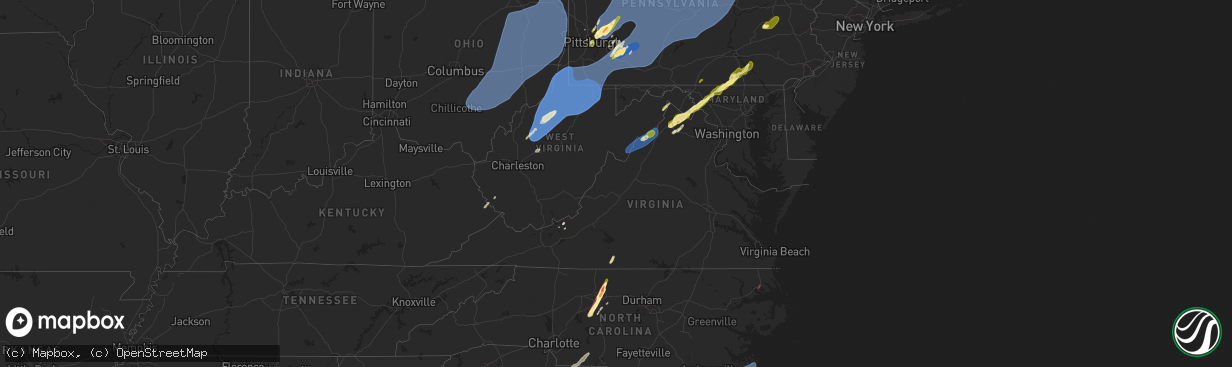
Hail Map in Virginia on March 16, 2025
The weather event in Virginia on March 16, 2025 includes Hail, Wind, and Tornado maps. 11 states and 1,646 cities were impacted and suffered possible damage. The total estimated number of properties impacted is 30,755.
Want more than just the map?
Turn this storm into a full workflow.
- Owner + property data so you know who to knock
- OnDemand branded weather history reports to win the "did we even have hail?" argument
- RoofTrace estimate so reps stop guessing numbers at the door
Bought this map? Upgrade within 7 days and we'll credit the $230. (10-15 min setup call)
Hail
Wind
Tornado
30,755
Estimated number of impacted properties by a 1.00" hail or larger0
Estimated number of impacted properties by a 1.75" hail or larger0
Estimated number of impacted properties by a 2.50" hail or largerStorm reports in Virginia
Virginia
| Date | Description |
|---|---|
| 03/16/20255:29 PM CDT | Tree down at the intersection of quicksburg rd and boiling springs lane |
| 03/16/20255:26 PM CDT | Shingles blown off of a house at the 1200 block of senedo rd in mt jackson. |
| 03/16/20254:22 PM CDT | Biggest hail stone half dollar. Most nickel to quarter. 5:22 to 5:26 pm. |
| 03/16/20254:12 PM CDT | Damage to window and siding. |
| 03/16/20253:21 PM CDT | Corrects previous tstm wnd dmg report from 3 sw dublin. Damage to window and siding. |
| 03/16/20259:48 AM CDT | Several trees reported down near the community of prater near dickenson highway. |
| 03/16/202512:08 AM CDT | Dominion reports damaged power lines at windmill point rd. |
| 03/15/202511:44 PM CDT | A tree fell along the road. |
| 03/15/202511:40 PM CDT | Dominion reports damaged power lines at pebble beach ln. |
| 03/15/20257:52 PM CDT | 5 trees downed in various locations along mount torrey rd and signal ln. |
| 03/15/20257:25 PM CDT | A local report indicates 1.00 inch wind near Berryville |
All States Impacted by Hail Map on March 16, 2025
Cities Impacted by Hail Map on March 16, 2025
- Fresno, OH
- Baltic, OH
- Stone Creek, OH
- Sugarcreek, OH
- New Philadelphia, OH
- South Williamson, KY
- Sidney, KY
- Belfry, KY
- Canada, KY
- Williamson, WV
- Delbarton, WV
- Forest Hills, KY
- Spencer, WV
- Creston, WV
- Reedy, WV
- Harrisville, WV
- Smithville, WV
- Macfarlan, WV
- Left Hand, WV
- Newton, WV
- Amma, WV
- Looneyville, WV
- Pennsboro, WV
- Pullman, WV
- Berea, WV
- Auburn, WV
- West Union, WV
- New Milton, WV
- Salem, WV
- Alma, WV
- Mount Clare, WV
- Clarksburg, WV
- Lost Creek, WV
- Meadowbrook, WV
- Hepzibah, WV
- Lumberport, WV
- Wallace, WV
- Bridgeport, WV
- Shinnston, WV
- Center Point, WV
- Spelter, WV
- Flemington, WV
- Fairmont, WV
- Grafton, WV
- Anmoore, WV
- Morgantown, WV
- Independence, WV
- Enterprise, WV
- Worthington, WV
- Navarre, OH
- Dalton, OH
- North Lawrence, OH
- Orrville, OH
- Canton, OH
- Canal Fulton, OH
- Massillon, OH
- Brewster, OH
- Clinton, OH
- Akron, OH
- Uniontown, OH
- North Canton, OH
- Hartville, OH
- Louisville, OH
- Middlebranch, OH
- Alliance, OH
- Arthurdale, WV
- Reedsville, WV
- Newburg, WV
- Masontown, WV
- Indianola, PA
- Cheswick, PA
- New Kensington, PA
- Pittsburgh, PA
- Oakmont, PA
- Harwick, PA
- Allison Park, PA
- Verona, PA
- Russellton, PA
- Tarentum, PA
- Gibsonia, PA
- Bakerstown, PA
- Glenshaw, PA
- Springdale, PA
- Creighton, PA
- Natrona Heights, PA
- Brackenridge, PA
- Sarver, PA
- Leechburg, PA
- Freeport, PA
- Vandergrift, PA
- Hyde Park, PA
- Kittanning, PA
- Ford City, PA
- Ford Cliff, PA
- McGrann, PA
- Templeton, PA
- Saxonburg, PA
- Valencia, PA
- Butler, PA
- Baden, PA
- McKees Rocks, PA
- Apollo, PA
- Manorville, PA
- Brunswick, GA
- Masontown, PA
- Garards Fort, PA
- Jefferson, PA
- Carmichaels, PA
- Rices Landing, PA
- Greensboro, PA
- Ronco, PA
- Nemacolin, PA
- Clarksville, PA
- Hopwood, PA
- New Salem, PA
- Dunbar, PA
- Oliver, PA
- Republic, PA
- Lemont Furnace, PA
- Brownsville, PA
- Crucible, PA
- Fairbank, PA
- Uledi, PA
- Smock, PA
- McClellandtown, PA
- Smithfield, PA
- Cardale, PA
- East Millsboro, PA
- Uniontown, PA
- Adah, PA
- Grindstone, PA
- Merrittstown, PA
- Mount Braddock, PA
- Allenport, PA
- West Newton, PA
- Alverton, PA
- Coal Center, PA
- Denbo, PA
- New Stanton, PA
- Elco, PA
- Perryopolis, PA
- Vanderbilt, PA
- Latrobe, PA
- Wyano, PA
- Fayette City, PA
- Dawson, PA
- Ruffs Dale, PA
- Millsboro, PA
- Tarrs, PA
- Hiller, PA
- Yukon, PA
- Bovard, PA
- Pleasant Unity, PA
- Hunker, PA
- California, PA
- Smithton, PA
- Scottdale, PA
- Vestaburg, PA
- Luxor, PA
- Roscoe, PA
- Youngwood, PA
- Stockdale, PA
- Dickerson Run, PA
- Connellsville, PA
- Everson, PA
- Allison, PA
- Wickhaven, PA
- La Belle, PA
- Newell, PA
- Star Junction, PA
- New Alexandria, PA
- Belle Vernon, PA
- Mount Pleasant, PA
- Fredericktown, PA
- Keisterville, PA
- Greensburg, PA
- Waltersburg, PA
- Daisytown, PA
- West Leisenring, PA
- Melcroft, PA
- Derry, PA
- Laughlintown, PA
- Somerset, PA
- Boswell, PA
- Jennerstown, PA
- Jones Mills, PA
- Rockwood, PA
- Loyalhanna, PA
- Youngstown, PA
- Stahlstown, PA
- Jenners, PA
- Friedens, PA
- Mill Run, PA
- Normalville, PA
- Central City, PA
- Acme, PA
- Shanksville, PA
- Hidden Valley, PA
- Bradenville, PA
- White, PA
- Hostetter, PA
- Champion, PA
- Indian Head, PA
- Stoystown, PA
- Quecreek, PA
- Gray, PA
- Rector, PA
- Ligonier, PA
- Acosta, PA
- Donegal, PA
- Westover, PA
- Nicktown, PA
- Davidsville, PA
- Patton, PA
- La Jose, PA
- Jerome, PA
- Robinson, PA
- Coral, PA
- Mineral Point, PA
- Cairnbrook, PA
- Armagh, PA
- Marsteller, PA
- Johnstown, PA
- Saint Benedict, PA
- South Fork, PA
- Brush Valley, PA
- Belsano, PA
- Spangler, PA
- Seward, PA
- Nanty Glo, PA
- Elmora, PA
- Twin Rocks, PA
- New Derry, PA
- Northern Cambria, PA
- New Florence, PA
- Saint Michael, PA
- Elton, PA
- Carrolltown, PA
- Windber, PA
- Hastings, PA
- Summerhill, PA
- Clymer, PA
- Ebensburg, PA
- Alverda, PA
- Homer City, PA
- Emeigh, PA
- Indiana, PA
- Penn Run, PA
- Dilltown, PA
- Parkhill, PA
- Josephine, PA
- Mentcle, PA
- Colver, PA
- Cherry Tree, PA
- Bolivar, PA
- Vintondale, PA
- Strongstown, PA
- Salix, PA
- Hollsopple, PA
- Heilwood, PA
- Sidman, PA
- Seanor, PA
- Blairsville, PA
- Black Lick, PA
- Hooversville, PA
- Loretto, PA
- Beaverdale, PA
- Portage, PA
- Saint Boniface, PA
- Lilly, PA
- Wilmore, PA
- Alum Bank, PA
- New Paris, PA
- Schellsburg, PA
- East Freedom, PA
- Duncansville, PA
- Queen, PA
- Cresson, PA
- Claysburg, PA
- Dysart, PA
- Chest Springs, PA
- Gallitzin, PA
- Ashville, PA
- Imler, PA
- Cassandra, PA
- Osterburg, PA
- Coalport, PA
- Rockton, PA
- Penfield, PA
- Flinton, PA
- Du Bois, PA
- Altoona, PA
- Mahaffey, PA
- Ridgway, PA
- Curwensville, PA
- Grampian, PA
- Kersey, PA
- Irvona, PA
- Brockport, PA
- Luthersburg, PA
- Johnsonburg, PA
- Commodore, PA
- Stump Creek, PA
- Starford, PA
- Reynoldsville, PA
- Glen Campbell, PA
- Big Run, PA
- Troutville, PA
- Arcadia, PA
- Rossiter, PA
- Brockway, PA
- Sykesville, PA
- Falls Creek, PA
- Burnside, PA
- Gipsy, PA
- Dixonville, PA
- Lucernemines, PA
- Rochester Mills, PA
- Hillsdale, PA
- Punxsutawney, PA
- Ernest, PA
- Marion Center, PA
- Saint Marys, PA
- Weedville, PA
- Benezett, PA
- Hollidaysburg, PA
- Newry, PA
- Williamsburg, PA
- Blandburg, PA
- Madera, PA
- Glen Hope, PA
- Tyrone, PA
- West Decatur, PA
- Tipton, PA
- Ramey, PA
- Clearfield, PA
- Roaring Spring, PA
- Philipsburg, PA
- Glen Richey, PA
- Fallentimber, PA
- New Millport, PA
- Hyde, PA
- Olanta, PA
- Houtzdale, PA
- Smithmill, PA
- Bellwood, PA
- Beccaria, PA
- Brisbin, PA
- Morrisdale, PA
- Osceola Mills, PA
- Frenchville, PA
- Wilcox, PA
- Byrnedale, PA
- Sandy Ridge, PA
- Wallaceton, PA
- Force, PA
- Bigler, PA
- Crosby, PA
- Smethport, PA
- Mineral Springs, PA
- Woodland, PA
- Driftwood, PA
- Emporium, PA
- Port Allegany, PA
- Huntingdon, PA
- Grassflat, PA
- Allport, PA
- Hawk Run, PA
- Alexandria, PA
- Pennsylvania Furnace, PA
- Warriors Mark, PA
- Spruce Creek, PA
- Munson, PA
- Kylertown, PA
- Winburne, PA
- Lanse, PA
- Port Matilda, PA
- Drifting, PA
- Petersburg, PA
- Karthaus, PA
- Pottersdale, PA
- Sinnamahoning, PA
- Roulette, PA
- Austin, PA
- Coudersport, PA
- Julian, PA
- Westport, PA
- Moshannon, PA
- Cadogan, PA
- Genesee, PA
- Clarence, PA
- Andover, NY
- Ulysses, PA
- Renovo, PA
- Snow Shoe, PA
- Wellsville, NY
- Galeton, PA
- Whitesville, NY
- Cross Fork, PA
- Mill Creek, PA
- Beech Creek, PA
- State College, PA
- Bellefonte, PA
- Lemont, PA
- University Park, PA
- Pine Grove Mills, PA
- Belleville, PA
- Fleming, PA
- Allensville, PA
- Orviston, PA
- McVeytown, PA
- Boalsburg, PA
- Centre Hall, PA
- Milesburg, PA
- Howard, PA
- Lewistown, PA
- Rexville, NY
- Troupsburg, NY
- Mills, PA
- Canisteo, NY
- North Bend, PA
- Lock Haven, PA
- Harrison Valley, PA
- Sabinsville, PA
- Reedsville, PA
- Westfield, PA
- Greenwood, NY
- Spring Mills, PA
- Gaines, PA
- Jasper, NY
- Mill Hall, PA
- Cammal, PA
- Cameron, NY
- Blanchard, PA
- Cedar Run, PA
- Milroy, PA
- Osceola, PA
- Cameron Mills, NY
- Waterville, PA
- Knoxville, PA
- Middlebury Center, PA
- Morris, PA
- Lamar, PA
- Slate Run, PA
- Jersey Mills, PA
- Wellsboro, PA
- Woodhull, NY
- Jersey Shore, PA
- Addison, NY
- Madisonburg, PA
- Rebersburg, PA
- Tioga, PA
- Bath, NY
- Lawrenceville, PA
- Elkland, PA
- Campbell, NY
- Avis, PA
- Coburn, PA
- Aaronsburg, PA
- Woodward, PA
- Trout Run, PA
- Millheim, PA
- Loganton, PA
- Townsend, GA
- Riceboro, GA
- Corning, NY
- Burdett, NY
- Millport, NY
- Montour Falls, NY
- Beaver Dams, NY
- Watkins Glen, NY
- Nelson, PA
- Savona, NY
- Pine City, NY
- Mansfield, PA
- Odessa, NY
- Horseheads, NY
- Bradford, NY
- Big Flats, NY
- Lindley, NY
- Painted Post, NY
- Covington, PA
- Milan, PA
- Shunk, PA
- Roaring Branch, PA
- Alba, PA
- Elmira, NY
- Blossburg, PA
- Cogan Station, PA
- Linden, PA
- Alpine, NY
- Chemung, NY
- Sayre, PA
- Troy, PA
- Erin, NY
- Cayuta, NY
- Granville Summit, PA
- Columbia Cross Roads, PA
- Breesport, NY
- Williamsport, PA
- Wellsburg, NY
- Liberty, PA
- Morris Run, PA
- Canton, PA
- Gillett, PA
- Mainesburg, PA
- Millerton, PA
- Ralston, PA
- Towanda, PA
- Ulster, PA
- East Smithfield, PA
- Athens, PA
- Pine Valley, NY
- Lowman, NY
- Winfield, PA
- McAlisterville, PA
- Laporte, PA
- Shamokin Dam, PA
- White Deer, PA
- Sunbury, PA
- Middleburg, PA
- Montoursville, PA
- Lewisburg, PA
- Muncy Valley, PA
- Watsontown, PA
- Catawissa, PA
- Montandon, PA
- Millmont, PA
- Lairdsville, PA
- Hughesville, PA
- Burnham, PA
- Milton, PA
- Monroeton, PA
- New Columbia, PA
- Mildred, PA
- Hillsgrove, PA
- Nescopeck, PA
- Mifflinville, PA
- Yeagertown, PA
- New Berlin, PA
- Montgomery, PA
- Turbotville, PA
- Laurelton, PA
- West Milton, PA
- Sweet Valley, PA
- Riverside, PA
- Shickshinny, PA
- Beavertown, PA
- Dushore, PA
- Lopez, PA
- Muncy, PA
- McClure, PA
- Millville, PA
- Bloomsburg, PA
- Orangeville, PA
- Berwick, PA
- Northumberland, PA
- Mifflinburg, PA
- Benton, PA
- Beaver Springs, PA
- Eagles Mere, PA
- Forksville, PA
- Selinsgrove, PA
- Stillwater, PA
- Allenwood, PA
- McEwensville, PA
- New Albany, PA
- Huntington Mills, PA
- Danville, PA
- Unityville, PA
- Mifflintown, PA
- Port Trevorton, PA
- Lockwood, NY
- Mount Carmel, PA
- Zion Grove, PA
- Granville, PA
- Le Raysville, PA
- Sugarloaf, PA
- Spencer, NY
- Mount Pleasant Mills, PA
- Dornsife, PA
- Trevorton, PA
- Thompsontown, PA
- Marion Heights, PA
- Waverly, NY
- Elysburg, PA
- Barton, NY
- Millerstown, PA
- Nichols, NY
- Rebuck, PA
- Shamokin, PA
- Herndon, PA
- Liverpool, PA
- Rome, PA
- Coal Township, PA
- Paxinos, PA
- Cocolamus, PA
- Hunlock Creek, PA
- Richfield, PA
- Mehoopany, PA
- Kulpmont, PA
- Wyalusing, PA
- Klingerstown, PA
- Locust Gap, PA
- Wysox, PA
- Sugar Run, PA
- Leck Kill, PA
- Laceyville, PA
- Oakland Mills, PA
- Stevensville, PA
- Newfield, NY
- Van Etten, NY
- Freeburg, PA
- Wilburton, PA
- Delmont, PA
- Saltsburg, PA
- Export, PA
- Slickville, PA
- Jeannette, PA
- Claridge, PA
- Locke, NY
- Moravia, NY
- Lansing, NY
- Groton, NY
- Auburn, NY
- Syracuse, NY
- Genoa, NY
- Scipio Center, NY
- Trumansburg, NY
- Marcellus, NY
- Skaneateles, NY
- Ithaca, NY
- Marietta, NY
- Camillus, NY
- King Ferry, NY
- Interlaken, NY
- Aurora, NY
- Ovid, NY
- Lodi, NY
- Hector, NY
- Rock Stream, NY
- Owego, NY
- Freeville, NY
- Homer, NY
- Dryden, NY
- Preble, NY
- Brooktondale, NY
- Cortland, NY
- Willseyville, NY
- Candor, NY
- Slaterville Springs, NY
- Nedrow, NY
- Liverpool, NY
- Berkshire, NY
- Jamesville, NY
- La Fayette, NY
- Tully, NY
- East Syracuse, NY
- Newark Valley, NY
- Apalachin, NY
- Endicott, NY
- Maine, NY
- Lisle, NY
- Fayetteville, NY
- Glen Aubrey, NY
- Apulia Station, NY
- Richford, NY
- Cincinnatus, NY
- Marathon, NY
- Whitney Point, NY
- Fabius, NY
- Harford, NY
- Truxton, NY
- McGraw, NY
- Little York, NY
- Little Meadows, PA
- Warren Center, PA
- Kirkville, NY
- New Woodstock, NY
- Manlius, NY
- Minoa, NY
- Johnson City, NY
- Willet, NY
- Smithville Flats, NY
- Binghamton, NY
- Vestal, NY
- Pitcher, NY
- De Ruyter, NY
- Castle Creek, NY
- Cicero, NY
- Cleveland, NY
- Williamstown, NY
- Constantia, NY
- Bridgeport, NY
- Chittenango, NY
- Cazenovia, NY
- Camden, NY
- Bernhards Bay, NY
- Brackney, PA
- Three Mile Bay, NY
- Mexico, NY
- Clayton, NY
- Cape Vincent, NY
- Henderson Harbor, NY
- Pulaski, NY
- Henderson, NY
- Sandy Creek, NY
- Richland, NY
- Belleville, NY
- Altmar, NY
- Chaumont, NY
- Dexter, NY
- Adams Center, NY
- Mannsville, NY
- Ellisburg, NY
- Lacona, NY
- Sackets Harbor, NY
- Adams, NY
- Calcium, NY
- Watertown, NY
- Lorraine, NY
- La Fargeville, NY
- Theresa, NY
- Alexandria Bay, NY
- Plessis, NY
- Redwood, NY
- Depauville, NY
- Rodman, NY
- Brownville, NY
- Evans Mills, NY
- Friendsville, PA
- Canastota, NY
- Westdale, NY
- Taberg, NY
- North Bay, NY
- Blossvale, NY
- Georgetown, NY
- Munnsville, NY
- Smyrna, NY
- Hamilton, NY
- Verona, NY
- Greene, NY
- Chenango Forks, NY
- Oxford, NY
- Plymouth, NY
- North Pitcher, NY
- Morrisville, NY
- Sylvan Beach, NY
- Oneida, NY
- South Otselic, NY
- Earlville, NY
- Rome, NY
- South Plymouth, NY
- Sherrill, NY
- Vernon, NY
- Wampsville, NY
- Norwich, NY
- Verona Beach, NY
- Durhamville, NY
- McDonough, NY
- Eaton, NY
- Port Crane, NY
- Vernon Center, NY
- Bouckville, NY
- Erieville, NY
- Lee Center, NY
- West Leyden, NY
- Ava, NY
- Boonville, NY
- Westernville, NY
- Oriskany, NY
- Holland Patent, NY
- Philadelphia, NY
- Black River, NY
- Copenhagen, NY
- Fort Drum, NY
- Redfield, NY
- Felts Mills, NY
- Carthage, NY
- Lowville, NY
- Ogdensburg, NY
- De Peyster, NY
- Heuvelton, NY
- Hammond, NY
- Antwerp, NY
- Gouverneur, NY
- Natural Bridge, NY
- Brohard, WV
- Middlebourne, WV
- Holden, WV
- Conklin, NY
- Kirkwood, NY
- Windsor, NY
- Harpursville, NY
- Afton, NY
- Bainbridge, NY
- Waterville, NY
- Sherburne, NY
- Madison, NY
- Hubbardsville, NY
- Remsen, NY
- Alder Creek, NY
- Cold Brook, NY
- Forestport, NY
- Woodgate, NY
- Eagle Bay, NY
- Old Forge, NY
- Thendara, NY
- Port Leyden, NY
- Oswegatchie, NY
- Wanakena, NY
- Harrisville, NY
- Rensselaer Falls, NY
- Fine, NY
- Russell, NY
- Richville, NY
- Croghan, NY
- Edwards, NY
- Hermon, NY
- De Kalb Junction, NY
- Colton, NY
- Norwood, NY
- Lisbon, NY
- Canton, NY
- Potsdam, NY
- Mathias, WV
- Bergton, VA
- Brandywine, WV
- Sugar Grove, WV
- Lancaster, SC
- Pageland, SC
- Basye, VA
- Hinton, VA
- Fulks Run, VA
- Milam, WV
- Criders, VA
- Broadway, VA
- Mount Jackson, VA
- Edinburg, VA
- Orkney Springs, VA
- Timberville, VA
- Quicksburg, VA
- Wardensville, WV
- Woodstock, VA
- Marshville, NC
- Edmeston, NY
- Morris, NY
- Otego, NY
- West Edmeston, NY
- Brookfield, NY
- North Brookfield, NY
- Garrattsville, NY
- Mount Upton, NY
- Guilford, NY
- Unadilla, NY
- Gilbertsville, NY
- New Berlin, NY
- South New Berlin, NY
- Laurens, NY
- New Lisbon, NY
- Nineveh, NY
- Mount Vision, NY
- West Winfield, NY
- Leonardsville, NY
- Clinton, NY
- Deansboro, NY
- New York Mills, NY
- Chadwicks, NY
- Marcy, NY
- Bridgewater, NY
- Clayville, NY
- Sauquoit, NY
- Utica, NY
- Yorkville, NY
- Cassville, NY
- New Hartford, NY
- Whitesboro, NY
- West Burlington, NY
- Burlington Flats, NY
- Poland, NY
- Herkimer, NY
- Ilion, NY
- Frankfort, NY
- Barneveld, NY
- Richfield Springs, NY
- Hartwick, NY
- Newport, NY
- Little Falls, NY
- Middleville, NY
- Winthrop, NY
- Saint Regis Falls, NY
- Parishville, NY
- Newton Falls, NY
- South Colton, NY
- Nicholville, NY
- Moira, NY
- North Lawrence, NY
- Brasher Falls, NY
- Bombay, NY
- Dickinson Center, NY
- Brushton, NY
- Fort Covington, NY
- Maurertown, VA
- Ridgeway, SC
- Winnsboro, SC
- Polkton, NC
- Cross Junction, VA
- Bloomery, WV
- Capon Bridge, WV
- Wadesboro, NC
- Great Falls, SC
- Peachland, NC
- Constable, NY
- Malone, NY
- North Bangor, NY
- Trinity, NC
- Sophia, NC
- Thomasville, NC
- Asheboro, NC
- Denton, NC
- Lexington, NC
- High Point, NC
- Greensboro, NC
- Randleman, NC
- Jamestown, NC
- Browns Summit, NC
- High View, WV
- Waynesboro, PA
- Quincy, PA
- Danville, VA
- Middletown, VA
- Reidsville, NC
- Winchester, VA
- Stephens City, VA
- Strasburg, VA
- Chatham, VA
- Dry Fork, VA
- Berryville, VA
- Boyce, VA
- Front Royal, VA
- White Post, VA
- Stephenson, VA
- Summit Point, WV
- Charles Town, WV
- Harpers Ferry, WV
- Millville, WV
- Knoxville, MD
- Lovettsville, VA
- Purcellville, VA
- Rohrersville, MD
- Brownsville, MD
- Brunswick, MD
- Jefferson, MD
- Burkittsville, MD
- Middletown, MD
- Myersville, MD
- Frederick, MD
- Braddock Heights, MD
- Thurmont, MD
- Walkersville, MD
- Woodsboro, MD
- Linden, VA
- Pottsville, PA
- Saint Clair, PA
- Port Carbon, PA
- Sharpsburg, MD
- Ranson, WV
- Rocky Ridge, MD
- Keymar, MD
- Emmitsburg, MD
- Taneytown, MD
- Union Bridge, MD
- Mar Lin, PA
- Seltzer, PA
- Schuylkill Haven, PA
- Orwigsburg, PA
- New Philadelphia, PA
- Cumbola, PA
- Tamaqua, PA
- New Ringgold, PA
- Middleport, PA
- Barnesville, PA
- Mary D, PA
- Brockton, PA
- Tuscarora, PA
- Coaldale, PA
- Nesquehoning, PA
- Lansford, PA
- Littlestown, PA
- Westminster, MD
- Hanover, PA
- Paris, VA
- Manchester, MD
- Julian, NC
- Climax, NC
- Spring Grove, PA
- Abbottstown, PA
- Thomasville, PA
- Glen Rock, PA
- Glenville, PA
- Seven Valleys, PA
- York, PA
- York New Salem, PA
- Dover, PA
- Dallastown, PA
- Manchester, PA
- Mount Wolf, PA
- Emigsville, PA
- Red Lion, PA
- Marietta, PA
- Wrightsville, PA
- Windsor, PA
- Mount Joy, PA
- Columbia, PA
- Washington Boro, PA
- Bairdford, PA
- Cabot, PA
- Fenelton, PA
- Chicora, PA
- Worthington, PA
- East Brady, PA
- Cowansville, PA
- Karns City, PA
- Parker, PA
- Rimersburg, PA
- East Vandergrift, PA
- North Apollo, PA
- Spring Church, PA
- Adrian, PA
- Clarion, PA
- New Bethlehem, PA
- Shippenville, PA
- Knox, PA
- Sligo, PA
- Rural Valley, PA
- Shelocta, PA
- Yatesboro, PA
- Brookville, PA
- Clarington, PA
- Strattanville, PA
- Marienville, PA
- Vowinckel, PA
- Cooksburg, PA
- Leeper, PA
- Sigel, PA
- Fairmount City, PA
- Summerville, PA
- Mayport, PA
- Corsica, PA
- Dayton, PA
- Ringgold, PA
- Timblin, PA
- Seminole, PA
- Worthville, PA
- Hawthorn, PA
- Coolspring, PA
- Knox Dale, PA
- Murrysville, PA
- Sprankle Mills, PA
- Smicksburg, PA
- Creekside, PA
- Northpoint, PA
- Oliveburg, PA
- Sagamore, PA
- Hamilton, PA
- Home, PA
- Walston, PA
- De Lancey, PA
- Anita, PA
- Valier, PA
- Le Roy, NY
- Bergen, NY
- Byron, NY
- Stafford, NY
- East Bethany, NY
- Piffard, NY
- Pavilion, NY
- Linwood, NY
- Brockport, NY
- Churchville, NY
- Caledonia, NY
- Spencerport, NY
- Mumford, NY
- Hilton, NY
- Scottsville, NY
- North Chili, NY
- Rochester, NY
- Rush, NY
- Avon, NY
- West Henrietta, NY
- Henrietta, NY
- Lima, NY
- Honeoye Falls, NY
- York, NY
- Geneseo, NY
- Livonia, NY
- Bloomfield, NY
- Hemlock, NY
- Honeoye, NY
- Mendon, NY
- Farmington, NY
- Pittsford, NY
- Fairport, NY
- East Rochester, NY
- Victor, NY
- Canandaigua, NY
- West Bloomfield, NY
- Ionia, NY
- Macedon, NY
- Palmyra, NY
- Lyons, NY
- Marion, NY
- Webster, NY
- Clifton Springs, NY
- Penfield, NY
- Phelps, NY
- Manchester, NY
- Newark, NY
- Walworth, NY
- Shortsville, NY
- Ontario, NY
- Wolcott, NY
- Sodus Point, NY
- Savannah, NY
- Williamson, NY
- Red Creek, NY
- North Rose, NY
- Clyde, NY
- Sodus, NY
- Hannibal, NY
- Sterling, NY
- Oswego, NY
- Martville, NY
- Warsaw, NY
- Bliss, NY
- Silver Springs, NY
- Wyoming, NY
- Perry, NY
- Gainesville, NY
- South Byron, NY
- Leicester, NY
- Retsof, NY
- Rockbridge, OH
- McArthur, OH
- South Bloomingville, OH
- Laurelville, OH
- Logan, OH
- Thornville, OH
- Somerset, OH
- Bremen, OH
- Junction City, OH
- Hopewell, OH
- Sugar Grove, OH
- Mount Perry, OH
- Lancaster, OH
- Heath, OH
- Glenford, OH
- Rushville, OH
- New Lexington, OH
- Jacksonville, OH
- Nelsonville, OH
- New Plymouth, OH
- Crooksville, OH
- Haydenville, OH
- Murray City, OH
- Glouster, OH
- Creola, OH
- Amesville, OH
- Chauncey, OH
- Buchtel, OH
- Athens, OH
- New Straitsville, OH
- Union Furnace, OH
- Corning, OH
- Millfield, OH
- Roseville, OH
- New Marshfield, OH
- Shawnee, OH
- The Plains, OH
- Trimble, OH
- Londonderry, OH
- White Cottage, OH
- Warsaw, OH
- Frazeysburg, OH
- Malta, OH
- Coshocton, OH
- Dresden, OH
- Nashport, OH
- Zanesville, OH
- Blue Rock, OH
- Conesville, OH
- Trinway, OH
- Mcconnelsville, OH
- Blissfield, OH
- Millersburg, OH
- Killbuck, OH
- Holmesville, OH
- Fredericksburg, OH
- Philo, OH
- Shreve, OH
- Wooster, OH
- Smithville, OH
- Apple Creek, OH
- Sterling, OH
- Marshallville, OH
- Chesterhill, OH
- Adamsville, OH
- Rittman, OH
- Norwich, OH
- Dundee, OH
- Strasburg, OH
- Mount Eaton, OH
- Duncan Falls, OH
- Chandlersville, OH
- Wilmot, OH
- New Concord, OH
- Doylestown, OH
- Beach City, OH
- West Lafayette, OH
- Cambridge, OH
- Mineral City, OH
- Magnolia, OH
- Zoar, OH
- Port Washington, OH
- Mogadore, OH
- Bolivar, OH
- Newcomerstown, OH
- East Canton, OH
- Stockport, OH
- Kimbolton, OH
- Sandyville, OH
- Atwater, OH
- East Sparta, OH
- Plainfield, OH
- Dover, OH
- Deerfield, OH
- Gnadenhutten, OH
- Paris, OH
- Limaville, OH
- Waynesburg, OH
- North Benton, OH
- Somerdale, OH
- Kensington, OH
- Byesville, OH
- Beverly, OH
- Bethesda, OH
- Carrollton, OH
- Belmont, OH
- Salesville, OH
- Sebring, OH
- Pleasant City, OH
- Homeworth, OH
- Lore City, OH
- Robertsville, OH
- Senecaville, OH
- Mechanicstown, OH
- Morristown, OH
- Old Washington, OH
- Flushing, OH
- Cumberland, OH
- Scio, OH
- Beloit, OH
- Quaker City, OH
- Saint Clairsville, OH
- Sarahsville, OH
- Jewett, OH
- Freeport, OH
- Dennison, OH
- Minerva, OH
- Tippecanoe, OH
- Barnesville, OH
- Summerfield, OH
- Midvale, OH
- Uhrichsville, OH
- East Rochester, OH
- Kipling, OH
- Belle Valley, OH
- Piedmont, OH
- Tuscarawas, OH
- Cadiz, OH
- Dellroy, OH
- Sherrodsville, OH
- Malvern, OH
- Bowerston, OH
- Caldwell, OH
- Amsterdam, OH
- Leesville, OH
- Hopedale, OH
- Bergholz, OH
- Mount Pleasant, OH
- Bloomingdale, OH
- Richmond, OH
- Rayland, OH
- Salem, OH
- Smithfield, OH
- Salineville, OH
- Dillonvale, OH
- East Springfield, OH
- Bridgeport, OH
- Lewisville, OH
- Hanoverton, OH
- Adena, OH
- Waterford, OH
- Rootstown, OH
- Ravenna, OH
- Diamond, OH
- Leavittsburg, OH
- Berlin Center, OH
- Lisbon, OH
- Newton Falls, OH
- Irondale, OH
- Summitville, OH
- North Jackson, OH
- Lake Milton, OH
- Canfield, OH
- Damascus, OH
- Warren, OH
- Hammondsville, OH
- North Lima, OH
- Niles, OH
- Wellsville, OH
- Washingtonville, OH
- Youngstown, OH
- Leetonia, OH
- Girard, OH
- Steubenville, OH
- Toronto, OH
- Mineral Ridge, OH
- Columbiana, OH
- Mingo Junction, OH
- McDonald, OH
- New Waterford, OH
- New Springfield, OH
- East Palestine, OH
- Newell, WV
- East Liverpool, OH
- Rogers, OH
- New Cumberland, WV
- Negley, OH
- Petersburg, OH
- Stratton, OH
- Empire, OH
- Chester, WV
- Weirton, WV
- New Manchester, WV
- Big Springs, WV
- Mount Zion, WV
- Glenville, WV
- Troy, WV
- Grantsville, WV
- Arnoldsburg, WV
- Coxs Mills, WV
- Alum Bridge, WV
- Big Bend, WV
- Elizabeth, WV
- Munday, WV
- Palestine, WV
- Millstone, WV
- Normantown, WV
- Camden, WV
- Orma, WV
- Porters Falls, WV
- Reader, WV
- Paden City, WV
- New Martinsville, WV
- Sistersville, WV
- Smithfield, WV
- Jacksonburg, WV
- Folsom, WV
- Pine Grove, WV
- Sardis, OH
- Ellenboro, WV
- Friendly, WV
- Petroleum, WV
- Saint Marys, WV
- Cairo, WV
- Mannington, WV
- Littleton, WV
- West Finley, PA
- Hundred, WV
- Powhatan Point, OH
- Clarington, OH
- Glen Easton, WV
- Dallas, WV
- Hannibal, OH
- New Matamoras, OH
- Aleppo, PA
- Proctor, WV
- Metz, WV
- Wind Ridge, PA
- New Freeport, PA
- Cameron, WV
- Wheeling, WV
- Moundsville, WV
- Burton, WV
- Claysville, PA
- Holbrook, PA
- West Alexander, PA
- Graysville, PA
- Waynesburg, PA
- Montana Mines, WV
- Pursglove, WV
- Farmington, WV
- Blacksville, WV
- Baxter, WV
- Maidsville, WV
- Carolina, WV
- Barrackville, WV
- Rivesville, WV
- Fairview, WV
- Spraggs, PA
- Mount Morris, PA
- Wana, WV
- Rachel, WV
- Brave, PA
- Osage, WV
- Granville, WV
- Dilliner, PA
- Lake Lynn, PA
- Bobtown, PA
- Point Marion, PA
- Prosperity, PA
- Scenery Hill, PA
- Beallsville, PA
- Marianna, PA
- Sycamore, PA
- Richeyville, PA
- Amity, PA
- Charleroi, PA
- Mather, PA
- Rogersville, PA
- New Geneva, PA
- Fairchance, PA
- Martin, PA
- Brownfield, PA
- Jane Lew, WV
- West Milford, WV
- Farmington, PA
- Bruceton Mills, WV
- Bretz, WV
- Triadelphia, WV
- Atlantic Beach, NC
- Morehead City, NC
- Beaufort, NC
- Davis, NC
- Smyrna, NC
- Stacy, NC
- Marshallberg, NC
- Gloucester, NC
- Harkers Island, NC
- Hertford, NC
- Elizabeth City, NC
- West Palm Beach, FL
- Pembroke, VA
- Staffordsville, VA
- Pearisburg, VA
- Blacksburg, VA
- Folkston, GA
- Rocky Point, NC
- Burgaw, NC
- Pulaski, VA
- Dublin, VA
- Bland, VA
- East Amherst, NY
- Buffalo, NY
- Sanborn, NY
- Newfane, NY
- North Tonawanda, NY
- Lockport, NY
- Wilson, NY
- Ransomville, NY
- Burt, NY
- Appleton, NY
- Barker, NY
- Olcott, NY
- Mount Jewett, PA
- Bolivar, NY
- Portville, NY
- Shinglehouse, PA
- Little Genesee, NY
- Turtlepoint, PA
- Ceres, NY
- Eldred, PA
- Scio, NY
- Allentown, NY
- Friendship, NY
- Alma, NY
- Belfast, NY
- Angelica, NY
- Cuba, NY
- Belmont, NY
- Almond, NY
- Caneadea, NY
- Black Creek, NY
- Fillmore, NY
- Alfred Station, NY
- Hornell, NY
- Alfred, NY
- Cohocton, NY
- Canaseraga, NY
- Avoca, NY
- Conesus, NY
- Springwater, NY
- Arkport, NY
- Hunt, NY
- Dalton, NY
- Swain, NY
- Wayland, NY
- Dansville, NY
- Houghton, NY
- Nunda, NY
- Prattsburgh, NY
- Rushville, NY
- Bellona, NY
- Atlanta, NY
- Stanley, NY
- Keuka Park, NY
- Branchport, NY
- Geneva, NY
- Pulteney, NY
- Middlesex, NY
- Penn Yan, NY
- Hammondsport, NY
- Dundee, NY
- Hall, NY
- Naples, NY
- Himrod, NY
- Dresden, NY
- Waterloo, NY
- Fayette, NY
- Seneca Falls, NY
- Union Springs, NY
- Romulus, NY
- Port Byron, NY
- Cayuga, NY
- Skaneateles Falls, NY
- Baldwinsville, NY
- Memphis, NY
- Jordan, NY
- Warners, NY
- Weedsport, NY
- Elbridge, NY
- Central Square, NY
- Phoenix, NY
- Brewerton, NY
- Clay, NY
- Pennellville, NY
- West Monroe, NY
- Nineveh, PA
- Lowber, PA
- Sutersville, PA
- Dunlevy, PA
- Donora, PA
- Irwin, PA
- Buena Vista, PA
- Webster, PA
- Herminie, PA
- Elizabeth, PA
- Monongahela, PA
- Monessen, PA
- Eighty Four, PA
- Van Voorhis, PA
- Cokeburg, PA
- New Eagle, PA
- Ellsworth, PA
- Finleyville, PA
- Bentleyville, PA
- Washington, PA
- Trafford, PA
- Forbes Road, PA
- Hannastown, PA
- Westmoreland City, PA
- Larimer, PA
- Manor, PA
- Mckeesport, PA
- Harrison City, PA
- Penn, PA
- Adamsburg, PA
- Arona, PA
- Madison, PA
- Rillton, PA
- Grapeville, PA
- Crabtree, PA
- Darragh, PA
- Avonmore, PA
- Clarksburg, PA
- Venetia, PA
- Homestead, PA
- Canonsburg, PA
- Houston, PA
- Bethel Park, PA
- Lawrence, PA
- Meadow Lands, PA
- Bridgeville, PA
- Muse, PA
- Strabane, PA
- Carnegie, PA
- West Mifflin, PA
- Braddock, PA
- South Park, PA
- Clairton, PA
- Presto, PA
- Gandeeville, WV
- Procious, WV
- Walton, WV
- Clendenin, WV
- Elkview, WV
- Bomont, WV
- Duck, WV
- Wallback, WV
- Rosedale, WV
- Nebo, WV
- Ivydale, WV
- Clay, WV
- Maysel, WV
- Chloe, WV
- Exchange, WV
- Frametown, WV
- Flatwoods, WV
- Copen, WV
- Cedarville, WV
- Gassaway, WV
- Burnsville, WV
- Shock, WV
- Horner, WV
- Orlando, WV
- Weston, WV
- Sand Fork, WV
- Linn, WV
- Walkersville, WV
- Volga, WV
- Philippi, WV
- Buckhannon, WV
- Thornton, WV
- Advent, WV
- Red House, WV
- Poca, WV
- Gay, WV
- Leon, WV
- Charleston, WV
- Buffalo, WV
- Ripley, WV
- Liberty, WV
- Kenna, WV
- Given, WV
- Le Roy, WV


