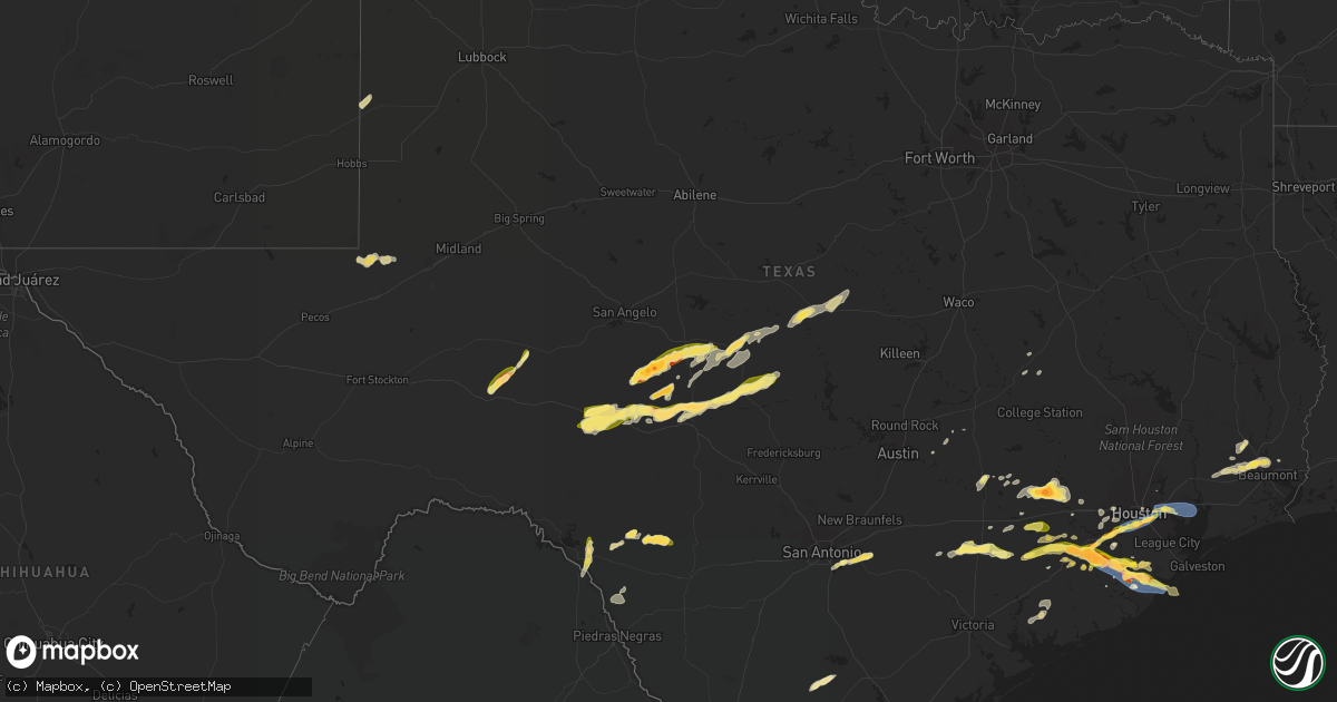
Hail Map in Texas on March 15, 2024
Get this storm
March 15 map
$229
one time, instant access
Download today. No call, no setup
Keep the $229
Bought the map and want the full workflow? Apply the entire $229 to a subscription within 7 days. None of it is wasted.
Every map, not just this one
This buys you this map. Subscription and you get every map we run, in the markets you choose from a few cities to whole states to nationwide. Plus real-time alerts the moment a storm fires.
Contact data
Name, contact info, occupancy, even credit band for addresses in the footprint. You go from where it hit to who to call.
Become the source they trust
Unlimited branding weather history reports on demand. You already have the documented answer ready for the property owner, and you are the one who showed up with it.
Property data and RoofTrace estimates
Pull up any address you have got, its value and the exact code rules for that jurisdiction, straight from One Click Code. Then RoofTrace estimates the squares, pitch, and roof value, priced the way you price.
Storm reports in Texas
Texas
| Date | Description |
|---|---|
| 03/15/20246:36 PM CDT | A local report indicates 66 MPH wind near 4 SSE Bailey's Prairie |
| 03/15/20246:29 PM CDT | A local report indicates 1.75 inch wind near 3 NNE Angleton |
| 03/15/20246:27 PM CDT | A local report indicates 1.00 inch wind near 3 NNW Angleton |
| 03/15/20246:21 PM CDT | Asos station klbx brazoria county airport. |
| 03/15/20246:15 PM CDT | Weather station at angleton police station. Sustained 53 mph w/ gust to 75 mph. |
| 03/15/20246:15 PM CDT | Handheld anemometer measurement. |
| 03/15/20246:11 PM CDT | Large tree uprooted and knocked down wood fencing. |
| 03/15/20246:11 PM CDT | Power lines and trees down at brazoria county fairgrounds. Time estimated by radar. |
| 03/15/20245:57 PM CDT | Mesonet station hlnt2 g103 san jacinto river at i-10 e. |
| 03/15/20245:57 PM CDT | A local report indicates 62 MPH wind near 1 SSW Highlands |
| 03/15/20245:30 PM CDT | Numerous power lines and trees down along with damage to a metal shed in damon. Time estimated by radar. |
| 03/15/20245:18 PM CDT | Roof blown off a house. |
| 03/15/20245:00 PM CDT | Quarter size hail was reported at laughlin afb. |
| 03/15/20244:58 PM CDT | Photo received of 1 inch hail. Time estimated by radar. |
| 03/15/20244:45 PM CDT | Numerous power lines down between beasley and needville. Time estimated by radar. |
| 03/15/20244:45 PM CDT | Photo of half dollar size hail near bevil oaks. Time estimated by radar. |
| 03/15/20244:45 PM CDT | Weatherflow station. |
| 03/15/20244:45 PM CDT | A local report indicates 1.50 inch wind near 3 WNW South Houston |
| 03/15/20244:40 PM CDT | Weatherflow station txsugar66. |
| 03/15/20244:30 PM CDT | A local report indicates 1.00 inch wind near 3 SE Southside Place |
| 03/15/20244:30 PM CDT | Story of a trees down across 7100 tram rd... Beaumont... Tx. |
| 03/15/20244:23 PM CDT | Report from mping: quarter |
| 03/15/20244:17 PM CDT | Report from mping: ping pong ball |
| 03/15/20244:17 PM CDT | A local report indicates 1.00 inch wind near 1 SW Stafford |
| 03/15/20244:10 PM CDT | A local report indicates 1.00 inch wind near 2 SSW Sugar Land |
| 03/15/20244:06 PM CDT | A local report indicates 1.00 inch wind near First Colony |
| 03/15/20244:03 PM CDT | Large tree down |
| 03/15/20244:00 PM CDT | A local report indicates 1.00 inch wind near 3 WSW Hallettsville |
| 03/15/20243:56 PM CDT | Quarter sized hail was reported. |
| 03/15/20243:30 PM CDT | Golf ball sized hail in pleak. |
| 03/15/20243:21 PM CDT | Report from mping: golf ball |
| 03/15/20243:17 PM CDT | Baseball sized hail in bellville. |
| 03/15/20243:17 PM CDT | Golf ball sized hail in bellville. |
| 03/15/20243:17 PM CDT | Tennis ball sized hail was reported. |
| 03/15/20243:15 PM CDT | Corrects previous tstm wnd dmg report from 3 wsw bellville. Tree down and barn heavily damaged near the intersection of mill creek road and kuykendall road. |
| 03/15/20243:15 PM CDT | Tree down near the intersection of mill creek road and kuykendall road. |
| 03/15/202410:00 AM CDT | Pea to quarter size hail reported. |
| 03/15/20249:01 AM CDT | A local report indicates 1.50 inch wind near 3 ENE Cleo |
| 03/15/20248:59 AM CDT | Corrects previous hail report from 2 n brady. Nickel to quarter size hail reported. |
| 03/15/20248:44 AM CDT | A local report indicates 1.00 inch wind near 3 W Brady |
| 03/15/20248:25 AM CDT | Nickle to quarter size hail reported in melvin... Tx... Over 1 inch or rain reported with the storm as well. |
| 03/15/20247:28 AM CDT | This is correction to a previous report. This report was received through facebook. |
| 03/15/20247:28 AM CDT | The report was received through facebook. |
| 03/15/20247:25 AM CDT | Radar estimated time. |
| 03/15/20245:12 AM CDT | Social media photos showed widespread hail near the intersection of hwy 36 and school st in needville... With a measured maximum diameter of 2.5 inches. |
| 03/15/20245:12 AM CDT | Social media photos showed wi |
| 03/15/20243:59 AM CDT | Report from mping: baseball |
| 03/15/20243:24 AM CDT | Widespread hail was reported just north of damon... With a maximum estimated diameter of 1.5 inches based on provided photos. |
| 03/15/20243:03 AM CDT | Local law enforcement reported hail damage to homes across needville. Hail size was estimated based on nearby photos received near time of the damage. |
| 03/15/20242:59 AM CDT | Corrects previous hail report from 1 nne needville. Social media photos showed widespread hail near the intersection of hwy 36 and school st in needville... With a meas |
| 03/15/20242:47 AM CDT | Local law enforcement reported golf ball sized hail in kendleton. |
| 03/14/202410:12 PM CDT | Asos station kcot cotulla measured a wind gust of 60 mph at 10:12 pm. |
| 03/14/20247:28 PM CDT | Mesonet station bzrt2 brazoria nwr. |
All States Impacted by Hail Map on March 15, 2024
Cities Impacted by Hail Map on March 15, 2024
- Beaver Falls, PA
- New Brighton, PA
- Zelienople, PA
- Fombell, PA
- Rochester, PA
- Iron City, TN
- Westpoint, TN
- Loretto, TN
- Lawrenceburg, TN
- Mount Carmel, IL
- Saint Francisville, IL
- Allendale, IL
- Sumner, IL
- Vincennes, IN
- Hazleton, IN
- Decker, IN
- Monroe City, IN
- Sonora, TX
- Eldorado, TX
- Christoval, TX
- Kermit, TX
- Ozona, TX
- Menard, TX
- Eden, TX
- Big Lake, TX
- Melvin, TX
- Brady, TX
- Junction, TX
- Oxford, AL
- Delta, AL
- Munford, AL
- Anniston, AL
- Heflin, AL
- London, TX
- Rochelle, TX
- Mason, TX
- Goldthwaite, TX
- San Saba, TX
- Fredonia, TX
- Pontotoc, TX
- Art, TX
- Valley Spring, TX
- Tuskegee, AL
- Union Springs, AL
- Fort McKavett, TX
- Jemison, AL
- Thorsby, AL
- Clanton, AL
- Franklin, TX
- Shorter, AL
- Pike Road, AL
- Montgomery, AL
- Notrees, TX
- Goldsmith, TX
- Calliham, TX
- Hamilton, TX
- Evant, TX
- Mullin, TX
- Richland Springs, TX
- Thrall, TX
- Elgin, TX
- Plains, TX
- Tilden, TX
- Mathews, AL
- Fitzpatrick, AL
- Philadelphia, MS
- Louisville, MS
- Lohn, TX
- Lexington, TX
- Raleigh, MS
- Cherokee, TX
- San Antonio, TX
- La Grange, TX
- Ledbetter, TX
- Giddings, TX
- Adkins, TX
- Georgiana, AL
- Red Level, AL
- Brantley, AL
- Greenville, AL
- Fort Mitchell, AL
- Cusseta, GA
- Omaha, GA
- Richland, GA
- Buena Vista, GA
- Ellaville, GA
- Oglethorpe, GA
- New Ulm, TX
- Cat Spring, TX
- Bellville, TX
- Sealy, TX
- La Vernia, TX
- Seguin, TX
- Stockdale, TX
- Dozier, AL
- Andersonville, GA
- Beasley, TX
- Rosenberg, TX
- Montezuma, GA
- Byromville, GA
- Americus, GA
- Shiner, TX
- Hallettsville, TX
- Brookshire, TX
- Vienna, GA
- Pinehurst, GA
- Needville, TX
- Richmond, TX
- Sugar Land, TX
- Missouri City, TX
- Pineview, GA
- Hawkinsville, GA
- Rochelle, GA
- Stafford, TX
- Brackettville, TX
- Houston, TX
- Abbeville, GA
- Eastman, GA
- Sour Lake, TX
- Beaumont, TX
- Rhine, GA
- Chauncey, GA
- Lumberton, TX
- Milan, GA
- Kountze, TX
- Del Rio, TX
- Laughlin Afb, TX
- Sublime, TX
- Galena Park, TX
- Pasadena, TX
- Uvalde, TX
- Guy, TX
- Omega, GA
- Tifton, GA
- Alamo, GA
- Lumber City, GA
- Damon, TX
- Leesburg, GA
- De Soto, GA
- Lenox, GA
- Rosharon, TX
- Channelview, TX
- Baytown, TX
- Highlands, TX
- Warwick, GA
- Angleton, TX
- Ariton, AL
- Brundidge, AL
- Opelika, AL
- Salem, AL
- Wetumpka, AL
- Round Top, TX
- Eufaula, AL
- Midway, AL
- Skipperville, AL
- McKenzie, AL
- Moultrie, GA
- Doerun, GA
- Sumner, GA
- Norman Park, GA
- Wharton, TX
- Fayetteville, TX
- Devers, TX
- Hempstead, TX
- Hardaway, AL
- Clio, AL
- Brenham, TX
- Vredenburgh, AL
- Whatley, AL
- Franklin, AL
- Hurtsboro, AL
- Chappell Hill, TX
- Industry, TX
- Lumpkin, GA
- Katy, TX
- Phenix City, AL
- Seale, AL
- Hatchechubbee, AL
- Dublin, GA
- Wallis, TX
- East Bernard, TX
- Gonzales, TX
- Elmendorf, TX
- Moulton, TX
- Ramer, AL
- Hope Hull, AL
- Burton, TX
- Liberty, TX
- Vidor, TX
- Hull, TX
- Winslow, AZ
- Danbury, TX
- Freeport, TX
- Clute, TX
- Lake Jackson, TX
- Galveston, TX
- Laredo, TX
- San Ygnacio, TX
- Alapaha, GA
- Clopton, AL
- Abbeville, AL
- Deer Park, TX
- La Porte, TX
- Quemado, TX
- Boling, TX
- Rebecca, GA
- Ashburn, GA
- Tallassee, AL
- Fitzgerald, GA
- Hebbronville, TX
- Zapata, TX
- Garwood, TX
- El Campo, TX
- Louise, TX
- Eagle Lake, TX
- Columbus, TX
- Alleyton, TX
- Louin, MS
- Monroeville, AL
- McRae Helena, GA
- Weimar, TX
- Schulenburg, TX
- Laurel, MS
- Encino, TX
- Garciasville, TX
- Rio Grande City, TX
- Sarita, TX
- Linn, TX
- Raymondville, TX
- Midfield, TX
- Lyford, TX
- Armstrong, TX
- San Perlita, TX
- Falfurrias, TX
- Roma, TX
- Lolita, TX
- West Columbia, TX
- Edinburg, TX
- Blessing, TX
- Hargill, TX
- Port Mansfield, TX
- Alvin, TX
- Liverpool, TX
- San Isidro, TX
- Guerra, TX
- Santa Fe, TX
- Glen Flora, TX
- Harlingen, TX


