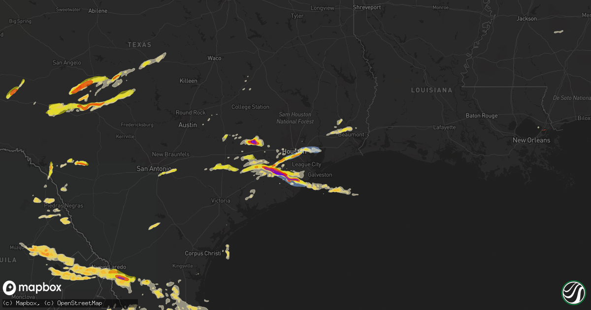
Hail Map on March 15, 2024
Get this storm
March 15 map
$229
one time, instant access
Download today. No call, no setup
Keep the $229
Bought the map and want the full workflow? Apply the entire $229 to a subscription within 7 days. None of it is wasted.
Every map, not just this one
This buys you this map. Subscription and you get every map we run, in the markets you choose from a few cities to whole states to nationwide. Plus real-time alerts the moment a storm fires.
Contact data
Name, contact info, occupancy, even credit band for addresses in the footprint. You go from where it hit to who to call.
Become the source they trust
Unlimited branding weather history reports on demand. You already have the documented answer ready for the property owner, and you are the one who showed up with it.
Property data and RoofTrace estimates
Pull up any address you have got, its value and the exact code rules for that jurisdiction, straight from One Click Code. Then RoofTrace estimates the squares, pitch, and roof value, priced the way you price.
States Impacted by Hail Map on March 15, 2024
Storm reports
Georgia
| Date | Description |
|---|---|
| 03/15/20245:45 PM CDT | Worth county dispatch reported a couple of powerlines down on w h saunders rd & ga-256. |
| 03/15/20245:45 PM CDT | Tift county dispatch reported a tree down on the intersection of ty-ty sparks rd & salem church rd. |
| 03/15/20245:37 PM CDT | Broadcast media reports hail up to the size of quarters falling near omega around 6:37pm edt. |
| 03/15/20245:35 PM CDT | Worth county dispatch reported a tree down on ew booth rd & eulan ln. |
| 03/15/20244:43 PM CDT | Multiple trees and powerlines down... Unsecured shed collapsed... Mobile home on wheeled trailer flipped and destroyed. |
| 03/15/20243:37 PM CDT | Local business report half inch to quarter sized hail in downtown byromville near youngblood ave and main st. |
| 03/15/20242:58 PM CDT | Up to quarter-sized hail observed near the intersection of broad street and hwy 26. |
| 03/15/20242:37 PM CDT | Local business reports golf ball sized hail near mill pond rd and ga41. |
| 03/14/20249:03 PM CDT | Delayed report. Tornado possible based emergency manager survey. Several down...snapped...and uprooted trees. Time based on radar. |
| 03/14/20248:03 PM CDT | Corrects previous tstm wnd dmg report from 2 ne willacoochee to change approximate time of occurrence. Delayed report. Tornado possible based emergency manager survey. |
| 03/14/20248:02 PM CDT | Delayed report. Time estimated by radar. Tree down on lupo lane and east baker highway in coffee county. Report received by coffee co dispatch at 2157. |
| 03/14/20247:54 PM CDT | Delayed report. Time estimated by radar. Power lines down reported to local coffee county dispatch at 2120. |
Louisiana
| Date | Description |
|---|---|
| 03/15/20243:05 PM CDT | Tree snapped around 8 to 10 feet above the ground and feel on a house on susan ln. |
| 03/15/20242:34 PM CDT | Out building at st. Amant high school football field damaged. |
| 03/15/20242:05 PM CDT | Wooden fence blown down. A few large tree limbs laying in the grass. Large tree uprooted. |
| 03/15/20242:05 PM CDT | Downed tree on a car. |
| 03/15/20242:02 PM CDT | Large tree fell on a home. |
| 03/15/20241:59 PM CDT | Damage to several small trees and fencing. Time estimated by radar. |
| 03/15/20241:45 PM CDT | Doors blown open... Trees down... Power outages. |
| 03/15/20241:45 PM CDT | Corrects previous tornado report from 7 wnw montpelier. Doors blown open... Trees down... Power outages. Possible weak tornado. |
| 03/15/20241:35 PM CDT | Csx bridge tender along the railroad at the pearl river crossing reported railroad signals knocked out and tree damage. Possible tornado sighting. Time estimated by rad |
| 03/15/20241:30 PM CDT | Photo and reports received of trees down in the melville area. Time estimated by radar. |
| 03/15/20241:30 PM CDT | Multiple trees down... Mostly pine snapped off. House damaged by falling tree. Damage all in one direction. |
| 03/15/20241:10 PM CDT | Thunderstorm winds downed a large tree across hwy 965 near the bluffs subdivision. Time estimated by radar. |
| 03/15/20241:10 PM CDT | Thunderstorm winds downed several trees in sage hill subdivision. Time estimated by radar. |
Mississippi
| Date | Description |
|---|---|
| 03/15/20241:43 PM CDT | Nine structures were damaged in sledge. Power lines reported down in the community and several residences had metal roofs peeled back. |
| 03/15/20247:20 AM CDT | Tree down in the spring community. |
Alabama
| Date | Description |
|---|---|
| 03/15/20241:12 PM CDT | Public report relayed via broadcast media of quarter size hail in franklin. Time estimated by radar. |
| 03/15/202412:17 PM CDT | Several reports of quarter size hail in southeastern montgomery and near pike road. |
| 03/15/20248:08 AM CDT | Wind gust to 52 k |
| 03/15/20248:08 AM CDT | Report of tree down across u.s. Highway 278 near mile marker 167. |
| 03/15/20248:08 AM CDT | Wind gust to 52 knots or 60 mph at kanb asos. |
| 03/15/20248:08 AM CDT | Wind gust to 52 knots or 60 mph at kanb asos. |
| 03/15/20247:57 AM CDT | Tree and power lines down along fletcher road near mcadory. |
| 03/15/20247:56 AM CDT | Roof off of a building... Part of it blocking a road. |
| 03/15/20247:41 AM CDT | Social media photos shared of a tree that fell onto a vehicle at young’s chapel congregational methodist church. One person was inside the car and escaped without inj |
| 03/15/20247:41 AM CDT | Social media photos shared of a tree that fell onto a vehicle at youngâs chapel congregational methodist church. One person was inside the car and escaped without |
| 03/15/20247:30 AM CDT | Report of a tree down blocking whorten bend road at whippoorwill... Report via social media. |
| 03/15/20247:20 AM CDT | Business owner reported damage to auto shop... Bay doors blown in... Insulation pulled out of ceiling and walls... Wall on second floor caved in. Near intersection of a |
| 03/15/20247:16 AM CDT | Trees reported down along a portion of rocky hollow cutoff road in etowah county. |
| 03/15/20247:12 AM CDT | Several trees down along fayette street... Some trees fell onto homes... Causing structural damage. {photos relayed via social media. |
| 03/15/20247:12 AM CDT | Tree reported down near the intersection of sweeney hollow road and tyler loop road in center point. |
| 03/15/20247:12 AM CDT | Report of several homes damaged in the camp sibert area southwest of attalla. |
Illinois
| Date | Description |
|---|---|
| 03/15/20247:28 AM CDT | A weak tornado was surveyed in central jersey county... Il south of jersey. Damage to trees... Siding... And roofs was observed. The width of the tornado was 100 yards. |
Texas
| Date | Description |
|---|---|
| 03/15/20246:36 PM CDT | A local report indicates 66 MPH wind near 4 SSE Bailey's Prairie |
| 03/15/20246:29 PM CDT | A local report indicates 1.75 inch wind near 3 NNE Angleton |
| 03/15/20246:27 PM CDT | A local report indicates 1.00 inch wind near 3 NNW Angleton |
| 03/15/20246:21 PM CDT | Asos station klbx brazoria county airport. |
| 03/15/20246:15 PM CDT | Handheld anemometer measurement. |
| 03/15/20246:15 PM CDT | Weather station at angleton police station. Sustained 53 mph w/ gust to 75 mph. |
| 03/15/20246:11 PM CDT | Power lines and trees down at brazoria county fairgrounds. Time estimated by radar. |
| 03/15/20246:11 PM CDT | Large tree uprooted and knocked down wood fencing. |
| 03/15/20245:57 PM CDT | A local report indicates 62 MPH wind near 1 SSW Highlands |
| 03/15/20245:57 PM CDT | Mesonet station hlnt2 g103 san jacinto river at i-10 e. |
| 03/15/20245:30 PM CDT | Numerous power lines and trees down along with damage to a metal shed in damon. Time estimated by radar. |
| 03/15/20245:18 PM CDT | Roof blown off a house. |
| 03/15/20245:00 PM CDT | Quarter size hail was reported at laughlin afb. |
| 03/15/20244:58 PM CDT | Photo received of 1 inch hail. Time estimated by radar. |
| 03/15/20244:45 PM CDT | A local report indicates 1.50 inch wind near 3 WNW South Houston |
| 03/15/20244:45 PM CDT | Weatherflow station. |
| 03/15/20244:45 PM CDT | Numerous power lines down between beasley and needville. Time estimated by radar. |
| 03/15/20244:45 PM CDT | Photo of half dollar size hail near bevil oaks. Time estimated by radar. |
| 03/15/20244:40 PM CDT | Weatherflow station txsugar66. |
| 03/15/20244:30 PM CDT | A local report indicates 1.00 inch wind near 3 SE Southside Place |
| 03/15/20244:30 PM CDT | Story of a trees down across 7100 tram rd... Beaumont... Tx. |
| 03/15/20244:23 PM CDT | Report from mping: quarter |
| 03/15/20244:17 PM CDT | A local report indicates 1.00 inch wind near 1 SW Stafford |
| 03/15/20244:17 PM CDT | Report from mping: ping pong ball |
| 03/15/20244:10 PM CDT | A local report indicates 1.00 inch wind near 2 SSW Sugar Land |
| 03/15/20244:06 PM CDT | A local report indicates 1.00 inch wind near First Colony |
| 03/15/20244:03 PM CDT | Large tree down |
| 03/15/20244:00 PM CDT | A local report indicates 1.00 inch wind near 3 WSW Hallettsville |
| 03/15/20243:56 PM CDT | Quarter sized hail was reported. |
| 03/15/20243:30 PM CDT | Golf ball sized hail in pleak. |
| 03/15/20243:21 PM CDT | Report from mping: golf ball |
| 03/15/20243:17 PM CDT | Golf ball sized hail in bellville. |
| 03/15/20243:17 PM CDT | Tennis ball sized hail was reported. |
| 03/15/20243:17 PM CDT | Baseball sized hail in bellville. |
| 03/15/20243:15 PM CDT | Corrects previous tstm wnd dmg report from 3 wsw bellville. Tree down and barn heavily damaged near the intersection of mill creek road and kuykendall road. |
| 03/15/20243:15 PM CDT | Tree down near the intersection of mill creek road and kuykendall road. |
| 03/15/202410:00 AM CDT | Pea to quarter size hail reported. |
| 03/15/20249:01 AM CDT | A local report indicates 1.50 inch wind near 3 ENE Cleo |
| 03/15/20248:59 AM CDT | Corrects previous hail report from 2 n brady. Nickel to quarter size hail reported. |
| 03/15/20248:44 AM CDT | A local report indicates 1.00 inch wind near 3 W Brady |
| 03/15/20248:25 AM CDT | Nickle to quarter size hail reported in melvin... Tx... Over 1 inch or rain reported with the storm as well. |
| 03/15/20247:28 AM CDT | The report was received through facebook. |
| 03/15/20247:28 AM CDT | This is correction to a previous report. This report was received through facebook. |
| 03/15/20247:25 AM CDT | Radar estimated time. |
| 03/15/20245:12 AM CDT | Social media photos showed widespread hail near the intersection of hwy 36 and school st in needville... With a measured maximum diameter of 2.5 inches. |
| 03/15/20245:12 AM CDT | Social media photos showed wi |
| 03/15/20243:59 AM CDT | Report from mping: baseball |
| 03/15/20243:24 AM CDT | Widespread hail was reported just north of damon... With a maximum estimated diameter of 1.5 inches based on provided photos. |
| 03/15/20243:03 AM CDT | Local law enforcement reported hail damage to homes across needville. Hail size was estimated based on nearby photos received near time of the damage. |
| 03/15/20242:59 AM CDT | Corrects previous hail report from 1 nne needville. Social media photos showed widespread hail near the intersection of hwy 36 and school st in needville... With a meas |
| 03/15/20242:47 AM CDT | Local law enforcement reported golf ball sized hail in kendleton. |
| 03/14/202410:12 PM CDT | Asos station kcot cotulla measured a wind gust of 60 mph at 10:12 pm. |
| 03/14/20247:28 PM CDT | Mesonet station bzrt2 brazoria nwr. |
Cities Impacted by Hail Map on March 15, 2024
- Beaver Falls, PA
- New Brighton, PA
- Zelienople, PA
- Fombell, PA
- Rochester, PA
- Iron City, TN
- Westpoint, TN
- Loretto, TN
- Lawrenceburg, TN
- Mount Carmel, IL
- Saint Francisville, IL
- Allendale, IL
- Sumner, IL
- Vincennes, IN
- Hazleton, IN
- Decker, IN
- Monroe City, IN
- Sonora, TX
- Eldorado, TX
- Christoval, TX
- Kermit, TX
- Ozona, TX
- Menard, TX
- Eden, TX
- Big Lake, TX
- Melvin, TX
- Brady, TX
- Junction, TX
- Oxford, AL
- Delta, AL
- Munford, AL
- Anniston, AL
- Heflin, AL
- London, TX
- Rochelle, TX
- Mason, TX
- Goldthwaite, TX
- San Saba, TX
- Fredonia, TX
- Pontotoc, TX
- Art, TX
- Valley Spring, TX
- Tuskegee, AL
- Union Springs, AL
- Fort McKavett, TX
- Jemison, AL
- Thorsby, AL
- Clanton, AL
- Franklin, TX
- Shorter, AL
- Pike Road, AL
- Montgomery, AL
- Notrees, TX
- Goldsmith, TX
- Calliham, TX
- Hamilton, TX
- Evant, TX
- Mullin, TX
- Richland Springs, TX
- Thrall, TX
- Elgin, TX
- Plains, TX
- Tilden, TX
- Mathews, AL
- Fitzpatrick, AL
- Philadelphia, MS
- Louisville, MS
- Lohn, TX
- Lexington, TX
- Raleigh, MS
- Cherokee, TX
- San Antonio, TX
- La Grange, TX
- Ledbetter, TX
- Giddings, TX
- Adkins, TX
- Georgiana, AL
- Red Level, AL
- Brantley, AL
- Greenville, AL
- Fort Mitchell, AL
- Cusseta, GA
- Omaha, GA
- Richland, GA
- Buena Vista, GA
- Ellaville, GA
- Oglethorpe, GA
- New Ulm, TX
- Cat Spring, TX
- Bellville, TX
- Sealy, TX
- La Vernia, TX
- Seguin, TX
- Stockdale, TX
- Dozier, AL
- Andersonville, GA
- Beasley, TX
- Rosenberg, TX
- Montezuma, GA
- Byromville, GA
- Americus, GA
- Shiner, TX
- Hallettsville, TX
- Brookshire, TX
- Vienna, GA
- Pinehurst, GA
- Needville, TX
- Richmond, TX
- Sugar Land, TX
- Missouri City, TX
- Pineview, GA
- Hawkinsville, GA
- Rochelle, GA
- Stafford, TX
- Brackettville, TX
- Houston, TX
- Abbeville, GA
- Eastman, GA
- Sour Lake, TX
- Beaumont, TX
- Rhine, GA
- Chauncey, GA
- Lumberton, TX
- Milan, GA
- Kountze, TX
- Del Rio, TX
- Laughlin Afb, TX
- Sublime, TX
- Galena Park, TX
- Pasadena, TX
- Uvalde, TX
- Guy, TX
- Omega, GA
- Tifton, GA
- Alamo, GA
- Lumber City, GA
- Damon, TX
- Leesburg, GA
- De Soto, GA
- Lenox, GA
- Rosharon, TX
- Channelview, TX
- Baytown, TX
- Highlands, TX
- Warwick, GA
- Angleton, TX
- Ariton, AL
- Brundidge, AL
- Opelika, AL
- Salem, AL
- Wetumpka, AL
- Round Top, TX
- Eufaula, AL
- Midway, AL
- Skipperville, AL
- McKenzie, AL
- Moultrie, GA
- Doerun, GA
- Sumner, GA
- Norman Park, GA
- Wharton, TX
- Fayetteville, TX
- Devers, TX
- Hempstead, TX
- Hardaway, AL
- Clio, AL
- Brenham, TX
- Vredenburgh, AL
- Whatley, AL
- Franklin, AL
- Hurtsboro, AL
- Chappell Hill, TX
- Industry, TX
- Lumpkin, GA
- Katy, TX
- Phenix City, AL
- Seale, AL
- Hatchechubbee, AL
- Dublin, GA
- Wallis, TX
- East Bernard, TX
- Gonzales, TX
- Elmendorf, TX
- Moulton, TX
- Ramer, AL
- Hope Hull, AL
- Burton, TX
- Liberty, TX
- Vidor, TX
- Hull, TX
- Winslow, AZ
- Danbury, TX
- Freeport, TX
- Clute, TX
- Lake Jackson, TX
- Galveston, TX
- Laredo, TX
- San Ygnacio, TX
- Alapaha, GA
- Clopton, AL
- Abbeville, AL
- Deer Park, TX
- La Porte, TX
- Quemado, TX
- Boling, TX
- Rebecca, GA
- Ashburn, GA
- Tallassee, AL
- Fitzgerald, GA
- Hebbronville, TX
- Zapata, TX
- Garwood, TX
- El Campo, TX
- Louise, TX
- Eagle Lake, TX
- Columbus, TX
- Alleyton, TX
- Louin, MS
- Monroeville, AL
- McRae Helena, GA
- Weimar, TX
- Schulenburg, TX
- Laurel, MS
- Encino, TX
- Garciasville, TX
- Rio Grande City, TX
- Sarita, TX
- Linn, TX
- Raymondville, TX
- Midfield, TX
- Lyford, TX
- Armstrong, TX
- San Perlita, TX
- Falfurrias, TX
- Roma, TX
- Lolita, TX
- West Columbia, TX
- Edinburg, TX
- Blessing, TX
- Hargill, TX
- Port Mansfield, TX
- Alvin, TX
- Liverpool, TX
- San Isidro, TX
- Guerra, TX
- Santa Fe, TX
- Glen Flora, TX
- Harlingen, TX