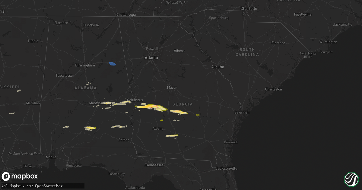
Hail Map in Georgia on March 15, 2024
Get this storm
March 15 map
$229
one time, instant access
Download today. No call, no setup
Keep the $229
Bought the map and want the full workflow? Apply the entire $229 to a subscription within 7 days. None of it is wasted.
Every map, not just this one
This buys you this map. Subscription and you get every map we run, in the markets you choose from a few cities to whole states to nationwide. Plus real-time alerts the moment a storm fires.
Contact data
Name, contact info, occupancy, even credit band for addresses in the footprint. You go from where it hit to who to call.
Become the source they trust
Unlimited branding weather history reports on demand. You already have the documented answer ready for the property owner, and you are the one who showed up with it.
Property data and RoofTrace estimates
Pull up any address you have got, its value and the exact code rules for that jurisdiction, straight from One Click Code. Then RoofTrace estimates the squares, pitch, and roof value, priced the way you price.
Storm reports in Georgia
Georgia
| Date | Description |
|---|---|
| 03/15/20245:45 PM CDT | Worth county dispatch reported a couple of powerlines down on w h saunders rd & ga-256. |
| 03/15/20245:45 PM CDT | Tift county dispatch reported a tree down on the intersection of ty-ty sparks rd & salem church rd. |
| 03/15/20245:37 PM CDT | Broadcast media reports hail up to the size of quarters falling near omega around 6:37pm edt. |
| 03/15/20245:35 PM CDT | Worth county dispatch reported a tree down on ew booth rd & eulan ln. |
| 03/15/20244:43 PM CDT | Multiple trees and powerlines down... Unsecured shed collapsed... Mobile home on wheeled trailer flipped and destroyed. |
| 03/15/20243:37 PM CDT | Local business report half inch to quarter sized hail in downtown byromville near youngblood ave and main st. |
| 03/15/20242:58 PM CDT | Up to quarter-sized hail observed near the intersection of broad street and hwy 26. |
| 03/15/20242:37 PM CDT | Local business reports golf ball sized hail near mill pond rd and ga41. |
| 03/14/20249:03 PM CDT | Delayed report. Tornado possible based emergency manager survey. Several down...snapped...and uprooted trees. Time based on radar. |
| 03/14/20248:03 PM CDT | Corrects previous tstm wnd dmg report from 2 ne willacoochee to change approximate time of occurrence. Delayed report. Tornado possible based emergency manager survey. |
| 03/14/20248:02 PM CDT | Delayed report. Time estimated by radar. Tree down on lupo lane and east baker highway in coffee county. Report received by coffee co dispatch at 2157. |
| 03/14/20247:54 PM CDT | Delayed report. Time estimated by radar. Power lines down reported to local coffee county dispatch at 2120. |
All States Impacted by Hail Map on March 15, 2024
Cities Impacted by Hail Map on March 15, 2024
- Beaver Falls, PA
- New Brighton, PA
- Zelienople, PA
- Fombell, PA
- Rochester, PA
- Iron City, TN
- Westpoint, TN
- Loretto, TN
- Lawrenceburg, TN
- Mount Carmel, IL
- Saint Francisville, IL
- Allendale, IL
- Sumner, IL
- Vincennes, IN
- Hazleton, IN
- Decker, IN
- Monroe City, IN
- Sonora, TX
- Eldorado, TX
- Christoval, TX
- Kermit, TX
- Ozona, TX
- Menard, TX
- Eden, TX
- Big Lake, TX
- Melvin, TX
- Brady, TX
- Junction, TX
- Oxford, AL
- Delta, AL
- Munford, AL
- Anniston, AL
- Heflin, AL
- London, TX
- Rochelle, TX
- Mason, TX
- Goldthwaite, TX
- San Saba, TX
- Fredonia, TX
- Pontotoc, TX
- Art, TX
- Valley Spring, TX
- Tuskegee, AL
- Union Springs, AL
- Fort McKavett, TX
- Jemison, AL
- Thorsby, AL
- Clanton, AL
- Franklin, TX
- Shorter, AL
- Pike Road, AL
- Montgomery, AL
- Notrees, TX
- Goldsmith, TX
- Calliham, TX
- Hamilton, TX
- Evant, TX
- Mullin, TX
- Richland Springs, TX
- Thrall, TX
- Elgin, TX
- Plains, TX
- Tilden, TX
- Mathews, AL
- Fitzpatrick, AL
- Philadelphia, MS
- Louisville, MS
- Lohn, TX
- Lexington, TX
- Raleigh, MS
- Cherokee, TX
- San Antonio, TX
- La Grange, TX
- Ledbetter, TX
- Giddings, TX
- Adkins, TX
- Georgiana, AL
- Red Level, AL
- Brantley, AL
- Greenville, AL
- Fort Mitchell, AL
- Cusseta, GA
- Omaha, GA
- Richland, GA
- Buena Vista, GA
- Ellaville, GA
- Oglethorpe, GA
- New Ulm, TX
- Cat Spring, TX
- Bellville, TX
- Sealy, TX
- La Vernia, TX
- Seguin, TX
- Stockdale, TX
- Dozier, AL
- Andersonville, GA
- Beasley, TX
- Rosenberg, TX
- Montezuma, GA
- Byromville, GA
- Americus, GA
- Shiner, TX
- Hallettsville, TX
- Brookshire, TX
- Vienna, GA
- Pinehurst, GA
- Needville, TX
- Richmond, TX
- Sugar Land, TX
- Missouri City, TX
- Pineview, GA
- Hawkinsville, GA
- Rochelle, GA
- Stafford, TX
- Brackettville, TX
- Houston, TX
- Abbeville, GA
- Eastman, GA
- Sour Lake, TX
- Beaumont, TX
- Rhine, GA
- Chauncey, GA
- Lumberton, TX
- Milan, GA
- Kountze, TX
- Del Rio, TX
- Laughlin Afb, TX
- Sublime, TX
- Galena Park, TX
- Pasadena, TX
- Uvalde, TX
- Guy, TX
- Omega, GA
- Tifton, GA
- Alamo, GA
- Lumber City, GA
- Damon, TX
- Leesburg, GA
- De Soto, GA
- Lenox, GA
- Rosharon, TX
- Channelview, TX
- Baytown, TX
- Highlands, TX
- Warwick, GA
- Angleton, TX
- Ariton, AL
- Brundidge, AL
- Opelika, AL
- Salem, AL
- Wetumpka, AL
- Round Top, TX
- Eufaula, AL
- Midway, AL
- Skipperville, AL
- McKenzie, AL
- Moultrie, GA
- Doerun, GA
- Sumner, GA
- Norman Park, GA
- Wharton, TX
- Fayetteville, TX
- Devers, TX
- Hempstead, TX
- Hardaway, AL
- Clio, AL
- Brenham, TX
- Vredenburgh, AL
- Whatley, AL
- Franklin, AL
- Hurtsboro, AL
- Chappell Hill, TX
- Industry, TX
- Lumpkin, GA
- Katy, TX
- Phenix City, AL
- Seale, AL
- Hatchechubbee, AL
- Dublin, GA
- Wallis, TX
- East Bernard, TX
- Gonzales, TX
- Elmendorf, TX
- Moulton, TX
- Ramer, AL
- Hope Hull, AL
- Burton, TX
- Liberty, TX
- Vidor, TX
- Hull, TX
- Winslow, AZ
- Danbury, TX
- Freeport, TX
- Clute, TX
- Lake Jackson, TX
- Galveston, TX
- Laredo, TX
- San Ygnacio, TX
- Alapaha, GA
- Clopton, AL
- Abbeville, AL
- Deer Park, TX
- La Porte, TX
- Quemado, TX
- Boling, TX
- Rebecca, GA
- Ashburn, GA
- Tallassee, AL
- Fitzgerald, GA
- Hebbronville, TX
- Zapata, TX
- Garwood, TX
- El Campo, TX
- Louise, TX
- Eagle Lake, TX
- Columbus, TX
- Alleyton, TX
- Louin, MS
- Monroeville, AL
- McRae Helena, GA
- Weimar, TX
- Schulenburg, TX
- Laurel, MS
- Encino, TX
- Garciasville, TX
- Rio Grande City, TX
- Sarita, TX
- Linn, TX
- Raymondville, TX
- Midfield, TX
- Lyford, TX
- Armstrong, TX
- San Perlita, TX
- Falfurrias, TX
- Roma, TX
- Lolita, TX
- West Columbia, TX
- Edinburg, TX
- Blessing, TX
- Hargill, TX
- Port Mansfield, TX
- Alvin, TX
- Liverpool, TX
- San Isidro, TX
- Guerra, TX
- Santa Fe, TX
- Glen Flora, TX
- Harlingen, TX


