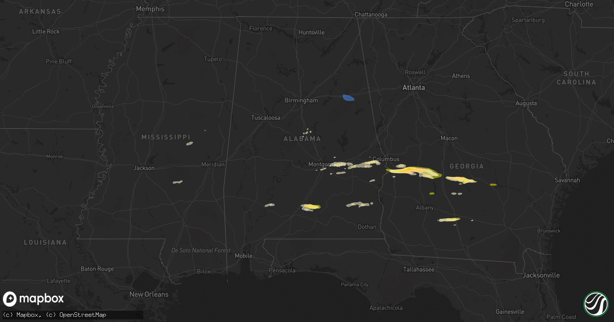
Hail Map in Alabama on March 15, 2024
Get this storm
March 15 map
$229
one time, instant access
Download today. No call, no setup
Keep the $229
Bought the map and want the full workflow? Apply the entire $229 to a subscription within 7 days. None of it is wasted.
Every map, not just this one
This buys you this map. Subscription and you get every map we run, in the markets you choose from a few cities to whole states to nationwide. Plus real-time alerts the moment a storm fires.
Contact data
Name, contact info, occupancy, even credit band for addresses in the footprint. You go from where it hit to who to call.
Become the source they trust
Unlimited branding weather history reports on demand. You already have the documented answer ready for the property owner, and you are the one who showed up with it.
Property data and RoofTrace estimates
Pull up any address you have got, its value and the exact code rules for that jurisdiction, straight from One Click Code. Then RoofTrace estimates the squares, pitch, and roof value, priced the way you price.
Storm reports in Alabama
Alabama
| Date | Description |
|---|---|
| 03/15/20241:12 PM CDT | Public report relayed via broadcast media of quarter size hail in franklin. Time estimated by radar. |
| 03/15/202412:17 PM CDT | Several reports of quarter size hail in southeastern montgomery and near pike road. |
| 03/15/20248:08 AM CDT | Report of tree down across u.s. Highway 278 near mile marker 167. |
| 03/15/20248:08 AM CDT | Wind gust to 52 knots or 60 mph at kanb asos. |
| 03/15/20248:08 AM CDT | Wind gust to 52 knots or 60 mph at kanb asos. |
| 03/15/20248:08 AM CDT | Wind gust to 52 k |
| 03/15/20247:57 AM CDT | Tree and power lines down along fletcher road near mcadory. |
| 03/15/20247:56 AM CDT | Roof off of a building... Part of it blocking a road. |
| 03/15/20247:41 AM CDT | Social media photos shared of a tree that fell onto a vehicle at young’s chapel congregational methodist church. One person was inside the car and escaped without inj |
| 03/15/20247:41 AM CDT | Social media photos shared of a tree that fell onto a vehicle at youngâs chapel congregational methodist church. One person was inside the car and escaped without |
| 03/15/20247:30 AM CDT | Report of a tree down blocking whorten bend road at whippoorwill... Report via social media. |
| 03/15/20247:20 AM CDT | Business owner reported damage to auto shop... Bay doors blown in... Insulation pulled out of ceiling and walls... Wall on second floor caved in. Near intersection of a |
| 03/15/20247:16 AM CDT | Trees reported down along a portion of rocky hollow cutoff road in etowah county. |
| 03/15/20247:12 AM CDT | Report of several homes damaged in the camp sibert area southwest of attalla. |
| 03/15/20247:12 AM CDT | Tree reported down near the intersection of sweeney hollow road and tyler loop road in center point. |
| 03/15/20247:12 AM CDT | Several trees down along fayette street... Some trees fell onto homes... Causing structural damage. {photos relayed via social media. |
All States Impacted by Hail Map on March 15, 2024
Cities Impacted by Hail Map on March 15, 2024
- Beaver Falls, PA
- New Brighton, PA
- Zelienople, PA
- Fombell, PA
- Rochester, PA
- Iron City, TN
- Westpoint, TN
- Loretto, TN
- Lawrenceburg, TN
- Mount Carmel, IL
- Saint Francisville, IL
- Allendale, IL
- Sumner, IL
- Vincennes, IN
- Hazleton, IN
- Decker, IN
- Monroe City, IN
- Sonora, TX
- Eldorado, TX
- Christoval, TX
- Kermit, TX
- Ozona, TX
- Menard, TX
- Eden, TX
- Big Lake, TX
- Melvin, TX
- Brady, TX
- Junction, TX
- Oxford, AL
- Delta, AL
- Munford, AL
- Anniston, AL
- Heflin, AL
- London, TX
- Rochelle, TX
- Mason, TX
- Goldthwaite, TX
- San Saba, TX
- Fredonia, TX
- Pontotoc, TX
- Art, TX
- Valley Spring, TX
- Tuskegee, AL
- Union Springs, AL
- Fort McKavett, TX
- Jemison, AL
- Thorsby, AL
- Clanton, AL
- Franklin, TX
- Shorter, AL
- Pike Road, AL
- Montgomery, AL
- Notrees, TX
- Goldsmith, TX
- Calliham, TX
- Hamilton, TX
- Evant, TX
- Mullin, TX
- Richland Springs, TX
- Thrall, TX
- Elgin, TX
- Plains, TX
- Tilden, TX
- Mathews, AL
- Fitzpatrick, AL
- Philadelphia, MS
- Louisville, MS
- Lohn, TX
- Lexington, TX
- Raleigh, MS
- Cherokee, TX
- San Antonio, TX
- La Grange, TX
- Ledbetter, TX
- Giddings, TX
- Adkins, TX
- Georgiana, AL
- Red Level, AL
- Brantley, AL
- Greenville, AL
- Fort Mitchell, AL
- Cusseta, GA
- Omaha, GA
- Richland, GA
- Buena Vista, GA
- Ellaville, GA
- Oglethorpe, GA
- New Ulm, TX
- Cat Spring, TX
- Bellville, TX
- Sealy, TX
- La Vernia, TX
- Seguin, TX
- Stockdale, TX
- Dozier, AL
- Andersonville, GA
- Beasley, TX
- Rosenberg, TX
- Montezuma, GA
- Byromville, GA
- Americus, GA
- Shiner, TX
- Hallettsville, TX
- Brookshire, TX
- Vienna, GA
- Pinehurst, GA
- Needville, TX
- Richmond, TX
- Sugar Land, TX
- Missouri City, TX
- Pineview, GA
- Hawkinsville, GA
- Rochelle, GA
- Stafford, TX
- Brackettville, TX
- Houston, TX
- Abbeville, GA
- Eastman, GA
- Sour Lake, TX
- Beaumont, TX
- Rhine, GA
- Chauncey, GA
- Lumberton, TX
- Milan, GA
- Kountze, TX
- Del Rio, TX
- Laughlin Afb, TX
- Sublime, TX
- Galena Park, TX
- Pasadena, TX
- Uvalde, TX
- Guy, TX
- Omega, GA
- Tifton, GA
- Alamo, GA
- Lumber City, GA
- Damon, TX
- Leesburg, GA
- De Soto, GA
- Lenox, GA
- Rosharon, TX
- Channelview, TX
- Baytown, TX
- Highlands, TX
- Warwick, GA
- Angleton, TX
- Ariton, AL
- Brundidge, AL
- Opelika, AL
- Salem, AL
- Wetumpka, AL
- Round Top, TX
- Eufaula, AL
- Midway, AL
- Skipperville, AL
- McKenzie, AL
- Moultrie, GA
- Doerun, GA
- Sumner, GA
- Norman Park, GA
- Wharton, TX
- Fayetteville, TX
- Devers, TX
- Hempstead, TX
- Hardaway, AL
- Clio, AL
- Brenham, TX
- Vredenburgh, AL
- Whatley, AL
- Franklin, AL
- Hurtsboro, AL
- Chappell Hill, TX
- Industry, TX
- Lumpkin, GA
- Katy, TX
- Phenix City, AL
- Seale, AL
- Hatchechubbee, AL
- Dublin, GA
- Wallis, TX
- East Bernard, TX
- Gonzales, TX
- Elmendorf, TX
- Moulton, TX
- Ramer, AL
- Hope Hull, AL
- Burton, TX
- Liberty, TX
- Vidor, TX
- Hull, TX
- Winslow, AZ
- Danbury, TX
- Freeport, TX
- Clute, TX
- Lake Jackson, TX
- Galveston, TX
- Laredo, TX
- San Ygnacio, TX
- Alapaha, GA
- Clopton, AL
- Abbeville, AL
- Deer Park, TX
- La Porte, TX
- Quemado, TX
- Boling, TX
- Rebecca, GA
- Ashburn, GA
- Tallassee, AL
- Fitzgerald, GA
- Hebbronville, TX
- Zapata, TX
- Garwood, TX
- El Campo, TX
- Louise, TX
- Eagle Lake, TX
- Columbus, TX
- Alleyton, TX
- Louin, MS
- Monroeville, AL
- McRae Helena, GA
- Weimar, TX
- Schulenburg, TX
- Laurel, MS
- Encino, TX
- Garciasville, TX
- Rio Grande City, TX
- Sarita, TX
- Linn, TX
- Raymondville, TX
- Midfield, TX
- Lyford, TX
- Armstrong, TX
- San Perlita, TX
- Falfurrias, TX
- Roma, TX
- Lolita, TX
- West Columbia, TX
- Edinburg, TX
- Blessing, TX
- Hargill, TX
- Port Mansfield, TX
- Alvin, TX
- Liverpool, TX
- San Isidro, TX
- Guerra, TX
- Santa Fe, TX
- Glen Flora, TX
- Harlingen, TX


