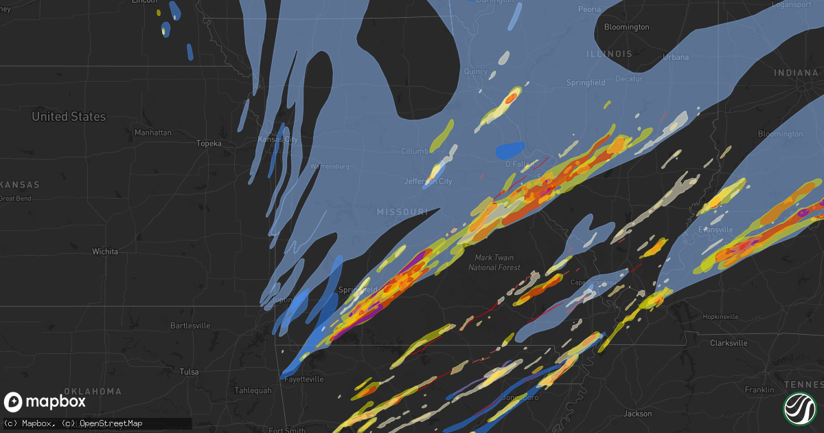
Hail Map in Missouri on March 14, 2025
Get this storm
March 14 map
$229
one time, instant access
Download today. No call, no setup
Keep the $229
Bought the map and want the full workflow? Apply the entire $229 to a subscription within 7 days. None of it is wasted.
Every map, not just this one
This buys you this map. Subscription and you get every map we run, in the markets you choose from a few cities to whole states to nationwide. Plus real-time alerts the moment a storm fires.
Contact data
Name, contact info, occupancy, even credit band for addresses in the footprint. You go from where it hit to who to call.
Become the source they trust
Unlimited branding weather history reports on demand. You already have the documented answer ready for the property owner, and you are the one who showed up with it.
Property data and RoofTrace estimates
Pull up any address you have got, its value and the exact code rules for that jurisdiction, straight from One Click Code. Then RoofTrace estimates the squares, pitch, and roof value, priced the way you price.
Storm reports in Missouri
Missouri
| Date | Description |
|---|---|
| 03/14/20256:57 PM CDT | About halfway between auxvasse and mexico. |
| 03/14/20256:54 PM CDT | Ping pong sized hail seymour. 1.5 inch. |
| 03/14/20256:50 PM CDT | Largest hail was quarter sized. |
| 03/14/20256:50 PM CDT | Report from mping... Quarter 1.00 inch hail. |
| 03/14/20256:50 PM CDT | Quarter sized hail at 176 and 65 hwy. Taney-christian line. |
| 03/14/20256:48 PM CDT | Large hail... Trees down... Holes in siding reported 7 miles east of niangua. Possible tor. |
| 03/14/20256:45 PM CDT | Mesonet station fw9032 seymour. |
| 03/14/20256:45 PM CDT | Picture of golf ball size hail. 1.75 inch hail. |
| 03/14/20256:40 PM CDT | Estimated maximum winds 90 to 100 mph. Damage included a roof torn off of home... Numerous barns destroyed... A collapsed cell phone tower... And snapped trees laying i |
| 03/14/20256:34 PM CDT | Report from mping... Ping pong ball 1.50 inch. |
| 03/14/20256:32 PM CDT | Quarter size hail emerald beach... Mo. |
| 03/14/20256:32 PM CDT | Quarter sized hail. 5 mile east of rogersville on 60 at the new rv park. |
| 03/14/20256:26 PM CDT | Multiple reports of downed tree limbs and property damage between clark and sturgeon. Time based on social media reports. |
| 03/14/20256:24 PM CDT | Corrects previous hail report from 4 nnw golden. Half dollar size hail emerald beach. |
| 03/14/20256:19 PM CDT | Outflow winds from weakening precipitation were likely to blame for these gusts based on radar. |
| 03/14/20256:19 PM CDT | Fire dept reports multiple building damaged near sumner. Timing estimated via radar. |
| 03/14/20256:18 PM CDT | Half dollar size hail... 1.3 miles south of 76 hwy on y hwy. |
| 03/14/20256:17 PM CDT | Half dollar size hail... 1.25 inch. Via contact. |
| 03/14/20256:16 PM CDT | Report from mping... Quarter... 1.00 in. |
| 03/14/20256:14 PM CDT | Nickle to quarter sized hail reported strafford. |
| 03/14/20256:13 PM CDT | In nixa high winds... Heavy rain... And quarter sized hail. On east side of nixa in forrest heights subdivision. |
| 03/14/20256:13 PM CDT | Report from mping... Quarter... 1.00 in. |
| 03/14/20256:12 PM CDT | Dime to golf ball sized. Ended at 625 pm. |
| 03/14/20256:12 PM CDT | Downed tree and wires near mckinsey street. Time estimated from radar. |
| 03/14/20256:12 PM CDT | Golf ball sized hail at 15th st and daniels in ozark. |
| 03/14/20256:12 PM CDT | Huge hail backed by strong winds destroyed window. |
| 03/14/20256:12 PM CDT | Report from mping... Quarter... 1.00 in. |
| 03/14/20256:11 PM CDT | Ozark 65 and hwy 14... Half dollar sized hail... And extremely heavy rain. |
| 03/14/20256:10 PM CDT | Nickel to quarter sized hail at 15th st and daniels in ozark. |
| 03/14/20256:08 PM CDT | Quarter and dime hail in ozark at godfathers pizza. |
| 03/14/20256:06 PM CDT | Baseball sized hail went through the highlandville area. |
| 03/14/20256:06 PM CDT | Half dollar size hail emerald beach. |
| 03/14/20256:01 PM CDT | Report from mping... Quarter 1.00 in. |
| 03/14/20256:00 PM CDT | A local report indicates 1.25 inch wind near Ozark |
| 03/14/20255:58 PM CDT | Em reports power outages and trees downed in cooper county. Timing estimated via radar. Il 3960 8769 trees uprooted... Structural damage to a trail |
| 03/14/20255:58 PM CDT | Em reports power outages and trees downed in cooper county. Timing estimated via radar. |
| 03/14/20255:58 PM CDT | Em reports multiple trees down around cooper county. Timing estimated via radar. |
| 03/14/20255:54 PM CDT | Report from mping... Half dollar... 1.25 in. |
| 03/14/20255:54 PM CDT | Reporting heavy rainfall and quarter-size hail around highway 39 and highway 76 east intersection north of shell knob. |
| 03/14/20255:51 PM CDT | Social media report of damage to a chicken coop and several trees and limbs down at a property near coatsville. Time estimated from radar. |
| 03/14/20255:39 PM CDT | Roof damage to a home in salisbury. Time estimated from radar. |
| 03/14/20255:38 PM CDT | Several reports of downed wires near boonville with numerous power outages. Time based on dispatch reports and confirmed from radar. |
| 03/14/20255:35 PM CDT | Several reports of downed power lines in the green city and greencastle area with numerous power outages. Time estimated from radar. |
| 03/14/20255:26 PM CDT | Picture of a garage with roof removed sent in by em. Timing estimated via radar. |
| 03/14/20255:24 PM CDT | Time confirmed from radar. |
| 03/14/20255:22 PM CDT | I have a report of 2 large tree limbs down near high and roberson in springfield. One limb is blocking high... The other is on roberson. |
| 03/14/20255:19 PM CDT | Downed wires and numerous power outages south of slater and gilliam. Time estimated from radar. |
| 03/14/20255:16 PM CDT | Civilian submitted report of thunderstorm wind damage near brookfield with multiple downed trees and power lines. Roof damage also reported to a house. Time confirmed f |
| 03/14/20255:15 PM CDT | Social media report of a downed tree at a residence in brookfield. Time confirmed from radar. |
| 03/14/20255:15 PM CDT | Reports of shingles torn off roofs. |
| 03/14/20255:12 PM CDT | Social media photos of a damaged outbuilding and tree limbs down in browning. Time estimated from radar. |
| 03/14/20255:09 PM CDT | Missouri ag mesonet southwest of linneus measured 59 mph wind gust. |
| 03/14/20255:07 PM CDT | Multiple power poles down in chariton county... With outages centered near keytesville and salisbury. Time estimated from radar. |
| 03/14/20255:06 PM CDT | A local report indicates 61 MPH wind near Sedalia Memorial Arpt |
| 03/14/20255:05 PM CDT | Corrects previous non-tstm wnd dmg report from 4 nw rothville. Tree uprooted near route tt. Time estimated from radar. |
| 03/14/20254:51 PM CDT | Power line down across from oak park on elliott. |
| 03/14/20254:47 PM CDT | Several outbuildings and multiple grain bins damaged. Also reported a near-continuous damage swath from 6 wsw laredo to this location. Time based on radar. |
| 03/14/20254:45 PM CDT | Metal building blown into trees and several limbs down at a property near princeton. Time estimated from radar. |
| 03/14/20254:39 PM CDT | Time confirmed from radar. |
| 03/14/20254:37 PM CDT | Radio station in trenton reports 70 mph winds. Relayed by em. |
| 03/14/20254:37 PM CDT | Em reports partial building collapse at east gate shopping center. |
| 03/14/20254:37 PM CDT | Roof blown off old ag building. Timing estimated from radar. |
| 03/14/20254:30 PM CDT | Time confirmed from radar. |
| 03/14/20254:30 PM CDT | Damage to garage/out building; roof blown across us-65. Timing estimated via radar. |
| 03/14/20254:29 PM CDT | Mu barton farm campus recorded 69 mph gust. Relayed by em. |
| 03/14/20254:20 PM CDT | Downed wires and power outages near maysville. Time estimated from radar. |
| 03/14/20254:16 PM CDT | Reports of semis overturned on us-50 west of warrensburg. Timing estimated from radar. |
| 03/14/20254:16 PM CDT | Reports of semis overturned on us-50 west of warrensburg. Timing estimated from radar. Tree limbs down. |
| 03/14/20254:13 PM CDT | Two power poles downed near stanberry. Time estimated from radar. |
| 03/14/20254:13 PM CDT | Awning blown over and other property damage just west of warrensburg. Time estimated from radar. |
| 03/14/20254:13 PM CDT | Downed tree and an outbuilding destroyed at a residence in winston. Time estimated from radar. |
| 03/14/20254:11 PM CDT | Damaged out buildings and roof blown off machine shed. |
| 03/14/20254:11 PM CDT | Power lines down by i-35 racetrack. Timing estimated via radar. |
| 03/14/20254:08 PM CDT | Several downed power lines near and east of sheridan... With multiple power outages reported. Time estimated from radar. |
| 03/14/20254:06 PM CDT | Downed tree and wires near route tt. Time estimated from radar. |
| 03/14/20254:06 PM CDT | Downed tree and wires near holstein road. Time estimated from radar. |
| 03/14/20254:03 PM CDT | Estimated; relayed from social media. |
| 03/14/20254:00 PM CDT | Social media report of downed tree limbs and minor property damage at a residence in holt from severe thunderstorm wind gusts. Time estimated from radar. |
| 03/14/20254:00 PM CDT | Picture of light pole fallen on car in a parking lot. Time estimated from radar. |
| 03/14/20253:58 PM CDT | Downed tree and wires near pennsylvania avenue. Time estimated from radar. |
| 03/14/20253:58 PM CDT | Social media report of minor tree damage from estimated 70 mph wind gusts from thunderstorms. Time estimated from radar. |
| 03/14/20253:58 PM CDT | A local report indicates 60 MPH wind near Oak Grove |
| 03/14/20253:55 PM CDT | Social media report of damage to a barn roof and to a chicken coop near helena. Time estimated from radar. |
| 03/14/20253:53 PM CDT | Tree fallen on house in excelsior springs. Timing estimated via radar. |
| 03/14/20253:53 PM CDT | Several downed power poles in the stewartsville area. Time estimated from radar. |
| 03/14/20253:53 PM CDT | Measured 58 mph wind gust at kstj. |
| 03/14/20253:50 PM CDT | Several large trees and limbs down damaging a property near excelsior springs. Time estimated from radar. |
| 03/14/20253:50 PM CDT | Report of a semi blown over along mo-210 via social media relayed by law enforcement. Timing estimated via radar. |
| 03/14/20253:50 PM CDT | Downed tree at a residence in richmond. Time estimated from radar. |
| 03/14/20253:50 PM CDT | Downed wires and power outages near county line road. Time estimated from radar. |
| 03/14/20253:49 PM CDT | Emergency management reported a downed power line in rural pleasant hill. Location estimated. |
| 03/14/20253:48 PM CDT | Minor property damage from strong thunderstorm winds at a residence north of oak grove. Time estimated from radar. |
| 03/14/20253:48 PM CDT | Downed wires near old santa fe trail. Time estimated from radar. |
| 03/14/20253:48 PM CDT | Windows blown out at a residence in independence. Time estimated from radar. |
| 03/14/20253:45 PM CDT | Roof damage to a residence in grain valley. Time estimated from radar. |
| 03/14/20253:45 PM CDT | Social media video of a fence blown over and minor damage to ballpark property at blue springs high school. Time estimated from radar. |
| 03/14/20253:45 PM CDT | Measured by stj asos. |
| 03/14/20253:45 PM CDT | Social media report of roof damage to a house from outflow wind gusts. Time based on video footage. |
| 03/14/20253:42 PM CDT | Social media video of a light pole snapped. Time estimated from radar. |
| 03/14/20253:42 PM CDT | Downed wires near rosine street. Time estimated from radar. |
| 03/14/20253:40 PM CDT | Roof damage to a business from severe thunderstorm winds. Time estimated from radar. |
| 03/14/20253:40 PM CDT | Roof damage to a business from severe thunderstorm winds. Time estimated from radar. |
| 03/14/20253:39 PM CDT | Several reports of wires down and power outages in the mosby area. Time confirmed from radar based on dispatch reports. |
| 03/14/20253:39 PM CDT | Downed tree at a residence in lees summit. Time estimated from radar. |
| 03/14/20253:39 PM CDT | Downed tree at a residence in lees summit. Time estimated from radar. |
| 03/14/20253:37 PM CDT | Multiple trees down around harrisonville. Timing estimated via radar. |
| 03/14/20253:37 PM CDT | A local report indicates 60 MPH wind near 2 NNE Lee's Summit |
| 03/14/20253:37 PM CDT | A local report indicates 60 MPH wind near 2 NNE Lees Summit |
| 03/14/20253:35 PM CDT | Public reported siding torn from a business and estimated winds of 60 mph. |
| 03/14/20253:35 PM CDT | Local law enforcement reporting trees down in blue springs... Including at least 1 reported on vehicle. |
| 03/14/20253:35 PM CDT | Public relayed... Via social media video... Estimated wind gusts 65 to 70 mph. |
| 03/14/20253:34 PM CDT | Large tree downed at a residence in raymore. Time estimated from radar. |
| 03/14/20253:34 PM CDT | Fence blown over and minor property damage at a residence in agency. Time estimated from radar. |
| 03/14/20253:29 PM CDT | Downed wires and numerous power outages between rushville and de kalb. Time estimated from radar. |
| 03/14/20253:29 PM CDT | Social media report of downed tree limbs at a property in dearborn. Time estimated from radar. |
| 03/14/20253:26 PM CDT | Tree fell onto a house. Time estimated from radar. |
| 03/14/20253:21 PM CDT | Social media report of an uprooted tree near 64th street. Time estimated from radar. |
| 03/14/20253:21 PM CDT | Downed wires near route 273. Time estimated from radar. |
| 03/14/20253:20 PM CDT | Downed tree at a residence in grandview. Time estimated from radar. |
| 03/14/20253:20 PM CDT | A local report indicates 60 MPH wind near Joplin |
| 03/14/20253:17 PM CDT | Downed wires and power outages in platte city. Time estimated from radar. |
| 03/14/20253:17 PM CDT | Mping report of tree limbs down at this location. Time confirmed from radar. |
| 03/14/20253:13 PM CDT | Propane station canopy blown down. Relayed via social media. Timing estimated from radar. |
| 03/14/20253:12 PM CDT | A local report indicates 67 MPH wind near 5 NW Anderson |
| 03/14/20253:11 PM CDT | Sporadic instances of wires down with attendant power outages between harrisonville and butler. Time based on dispatch reports and social media posts and confirmed by r |
| 03/14/20253:11 PM CDT | Large tree down near bales avenue. Time estimated from radar. |
| 03/14/20253:09 PM CDT | Downed tree near ward parkway. Time estimated from radar. |
| 03/14/20251:51 AM CDT | A local report indicates 1.75 inch wind near 2 N Pascola |
| 03/14/20251:42 AM CDT | Reported numerous large trees uprooted and on peoples homes. Worst damage is around jones park in kennett... Mo. Some trees snapped and debarking of trees also occurred |
| 03/14/20251:41 AM CDT | Report from mping: ping pong ball |
| 03/14/20251:40 AM CDT | Report from mping of half dollar |
| 03/14/20251:23 AM CDT | Tree down in wardell... Mo. Possible tornado damage. |
| 03/14/20251:06 AM CDT | Damage reported at a nursing home in sikeston near george e day parkway area. Possible tornado. |
| 03/14/20251:04 AM CDT | Power lines down in kennett... Mo. Possible tornado damage. |
| 03/14/20251:03 AM CDT | Multiple homes damaged... Damage to lowes... Significant damage to nursing home. Possible tornado. |
| 03/14/202512:36 AM CDT | Trained spotter reported a tornado just north of benton with power poles down. |
| 03/14/202512:28 AM CDT | Asos station kcgi cape girardeau mo. |
| 03/14/202512:16 AM CDT | *** 2 inj *** multiple structures damaged. 2 injuries. |
| 03/14/202512:00 AM CDT | Reported near pp highway and cr 254. |
| 03/13/202511:40 PM CDT | Damage reported on the south side of perryville. Possible tornado. |
| 03/13/202511:40 PM CDT | Multiple structures with major damage on the south side of perryville. |
| 03/13/202511:38 PM CDT | Report from mping of half dollar |
| 03/13/202511:35 PM CDT | Major damage reported to new covenant fellowship church and a neighboring trailer park on pp highway. |
| 03/13/202511:33 PM CDT | Many reports of damage in poplar bluff. Houses and buildings destroyed. Power outages and gas leaks reported. Possible tornado. |
| 03/13/202511:25 PM CDT | Near dd and bcr 810. |
| 03/13/202510:56 PM CDT | Report from mping: quarter |
| 03/13/202510:45 PM CDT | Report from mping: quarter |
| 03/13/202510:36 PM CDT | Report from mping: quarter |
| 03/13/202510:34 PM CDT | Multiple trees down. Time estimated by radar. |
| 03/13/202510:19 PM CDT | Report from mping: half dollar |
| 03/13/202510:18 PM CDT | Report from mping: half dollar |
| 03/13/202510:16 PM CDT | Windows blown out of a house near fremont. Possible tornado. Time estatimed. |
| 03/13/202510:14 PM CDT | Multiple limbs off trees. Some damage to roofs in area. |
| 03/13/202510:13 PM CDT | A local report indicates 1.00 inch wind near 1 SW Brentwood |
| 03/13/202510:11 PM CDT | Home reported destroyed on d highway near the carter/reynolds county line. Time estimated. |
| 03/13/202510:09 PM CDT | Report from mping: ping pong ball |
| 03/13/202510:08 PM CDT | Report from mping: quarter |
| 03/13/202510:08 PM CDT | A local report indicates 1.00 inch wind near Oakville |
| 03/13/202510:07 PM CDT | Report from mping: quarter |
| 03/13/202510:06 PM CDT | Report from mping: quarter |
| 03/13/202510:05 PM CDT | Report from mping: quarter |
| 03/13/202510:05 PM CDT | Broken windows and hail damaged cars. |
| 03/13/202510:05 PM CDT | A local report indicates 1.25 inch wind near Oakville |
| 03/13/202510:03 PM CDT | A local report indicates 2.00 inch wind near 2 SW Oakville |
| 03/13/202510:01 PM CDT | Report from mping: half dollar |
| 03/13/202510:01 PM CDT | A local report indicates 2.00 inch wind near Oakville |
| 03/13/20259:58 PM CDT | Report from mping: quarter |
| 03/13/20259:57 PM CDT | Tree on house intersection of harris and lindberg. |
| 03/13/20259:56 PM CDT | Report from mping: quarter |
| 03/13/20259:56 PM CDT | Report from mping: half dollar |
| 03/13/20259:55 PM CDT | A local report indicates 2.00 inch wind near 3 S Saint Louis |
| 03/13/20259:51 PM CDT | A local report indicates 1.00 inch wind near 1 NW Lemay |
| 03/13/20259:51 PM CDT | Report from mping: quarter |
| 03/13/20259:50 PM CDT | A local report indicates 1.00 inch wind near 1 SE Mehlville |
| 03/13/20259:50 PM CDT | He had 1-1.5 inch hail... Emailing a photo. |
| 03/13/20259:50 PM CDT | A local report indicates 1.25 inch wind near 2 SE Saint Louis |
| 03/13/20259:50 PM CDT | A local report indicates 1.00 inch wind near 1 NW Saint Louis |
| 03/13/20259:49 PM CDT | Report from mping: quarter |
| 03/13/20259:47 PM CDT | A local report indicates 1.00 inch wind near 3 NNE Lemay |
| 03/13/20259:47 PM CDT | Trees down and roof damage near liguori lane. |
| 03/13/20259:46 PM CDT | Report from mping: quarter |
| 03/13/20259:46 PM CDT | Report from mping: quarter |
| 03/13/20259:46 PM CDT | A local report indicates 1.00 inch wind near 3 NE Lemay |
| 03/13/20259:45 PM CDT | Report from mping: quarter |
| 03/13/20259:45 PM CDT | Report from mping: quarter |
| 03/13/20259:45 PM CDT | A local report indicates 1.50 inch wind near 3 SSE Saint Louis |
| 03/13/20259:45 PM CDT | A local report indicates 1.00 inch wind near 3 E Shrewsbury |
| 03/13/20259:45 PM CDT | Large transmission tower blown over. |
| 03/13/20259:44 PM CDT | A local report indicates 1.00 inch wind near Brentwood |
| 03/13/20259:43 PM CDT | Report from mping: quarter |
| 03/13/20259:43 PM CDT | A local report indicates 1.25 inch wind near 1 SE Crestwood |
| 03/13/20259:42 PM CDT | Report from mping: quarter |
| 03/13/20259:42 PM CDT | A local report indicates 1.00 inch wind near 1 S Lemay |
| 03/13/20259:42 PM CDT | A local report indicates 1.00 inch wind near 3 N Arnold |
| 03/13/20259:41 PM CDT | Report from mping: quarter |
| 03/13/20259:41 PM CDT | Report from mping: quarter |
| 03/13/20259:41 PM CDT | A local report indicates 1.00 inch wind near 2 SE Sunset Hills |
| 03/13/20259:40 PM CDT | Multiple homes with roof damage. Snapped trees. |
| 03/13/20259:40 PM CDT | Multiple houses with roof damage. Multiple trees down. |
| 03/13/20259:40 PM CDT | Multiple roofs damaged in neighborhood. Garage collapse. |
| 03/13/20259:40 PM CDT | Report from mping: hen egg |
| 03/13/20259:39 PM CDT | Report from mping: half dollar |
| 03/13/20259:39 PM CDT | Report from mping: quarter |
| 03/13/20259:38 PM CDT | Also wind damage and uprooted trees. |
| 03/13/20259:38 PM CDT | A local report indicates 1.00 inch wind near Fenton |
| 03/13/20259:38 PM CDT | Report from mping: quarter |
| 03/13/20259:37 PM CDT | Report from mping: quarter |
| 03/13/20259:37 PM CDT | A local report indicates 1.00 inch wind near 1 SW Crestwood |
| 03/13/20259:37 PM CDT | Report from mping: quarter |
| 03/13/20259:37 PM CDT | Multiple large trees down over new halls ferry road in florrisant. Time estimated by radar. |
| 03/13/20259:37 PM CDT | Trees on multiple house near washington and n st. Charles st. |
| 03/13/20259:36 PM CDT | Report from mping: quarter |
| 03/13/20259:36 PM CDT | St. Louis county em relayed report of a house damaged on brunswick drive with occupants trapped inside. |
| 03/13/20259:36 PM CDT | A local report indicates 1.00 inch wind near 1 E Murphy |
| 03/13/20259:35 PM CDT | Report of a tree down over a vehicle and block the street south of industrial lane. Time estimated from radar. |
| 03/13/20259:35 PM CDT | A local report indicates 1.75 inch wind near 2 S Fenton |
| 03/13/20259:35 PM CDT | A local report indicates 1.00 inch wind near 3 W Arnold |
| 03/13/20259:34 PM CDT | Trees on garage and homes at intersection of benedetta dr and domenico ct. Bridgeton. |
| 03/13/20259:34 PM CDT | A local report indicates 1.00 inch wind near 1 WSW Fenton |
| 03/13/20259:33 PM CDT | A local report indicates 1.00 inch wind near 2 NE Richwoods |
| 03/13/20259:33 PM CDT | Report from mping: quarter |
| 03/13/20259:31 PM CDT | Relayed report of a house destroyed on scotch drive in bridgeton. Time estimated from radar. |
| 03/13/20259:30 PM CDT | A local report indicates 1.00 inch wind near 2 S Murphy |
| 03/13/20259:30 PM CDT | Carport collapse. Multiple trees and power lines down... Roofs blown off. Neighborhood at vogel and miller in arnold... Mo. |
| 03/13/20259:30 PM CDT | Multiple trees on houses. |
| 03/13/20259:29 PM CDT | Report from mping: quarter |
| 03/13/20259:28 PM CDT | A local report indicates 1.75 inch wind near 1 WSW House Springs |
| 03/13/20259:27 PM CDT | Report from mping: quarter |
| 03/13/20259:27 PM CDT | A local report indicates 1.25 inch wind near 1 W Harvester |
| 03/13/20259:25 PM CDT | Report from mping: half dollar |
| 03/13/20259:25 PM CDT | Report from mping: ping pong ball |
| 03/13/20259:25 PM CDT | A local report indicates 1.75 inch wind near 1 WSW House Springs |
| 03/13/20259:24 PM CDT | Corrects previous tornado report from 3 ene morse mill. Multiple structures damaged at clayton huskey road and state route bb. One structure is collapsed. Time estimate |
| 03/13/20259:21 PM CDT | A local report indicates 1.00 inch wind near Cedar Hill |
| 03/13/20259:19 PM CDT | A local report indicates 1.75 inch wind near Catawissa |
| 03/13/20259:16 PM CDT | House damage. Possible tor. |
| 03/13/20259:14 PM CDT | Several homes reported with significant damage and multiple trees and powerlines down. |
| 03/13/20259:13 PM CDT | Nws storm survey concluded that an ef1 tornado with peak winds of 90 to 100 mph touched down just south of rover. The tornado travelled northeast for 6.25 miles before |
| 03/13/20259:10 PM CDT | A large tree down across the road on pp highway coming off 63... A quarter of a mile. Howell county. |
| 03/13/20259:09 PM CDT | A local report indicates 1.00 inch wind near Pacific |
| 03/13/20259:06 PM CDT | Tree limb sticking through roof. |
| 03/13/20259:06 PM CDT | Tree limb sticking through roof. Le dubois in 3838 8687 garage roof fell off and into the roadway on g |
| 03/13/20259:06 PM CDT | Public report of debris damage in the area... Howell county. |
| 03/13/20259:05 PM CDT | A local report indicates 78 MPH wind near Troy |
| 03/13/20259:02 PM CDT | A local report indicates 2.00 inch wind near 1 ESE Sullivan |
| 03/13/20259:00 PM CDT | Multiple buildings suffered damage near hwy at and hwy 100 near villa ridge. |
| 03/13/20259:00 PM CDT | Report of extensive damage from spotter confirmed tornado. Multiple buildings damaged and vehicles damaged on interstate 44. |
| 03/13/20259:00 PM CDT | Report from mping... Quarter hail... 1.00 inch. Time based on radar. |
| 03/13/20259:00 PM CDT | A local report indicates 1.75 inch wind near Cherryville |
| 03/13/20258:56 PM CDT | Multiple building with significant damage. Roofs blown off. |
| 03/13/20258:54 PM CDT | Tractor trailer impacted on i-44 near mile marker 247 near union. No further information available. Time estimated by radar. |
| 03/13/20258:54 PM CDT | House damaged and power lines down. Possible tor. |
| 03/13/20258:53 PM CDT | Building with significant roof damage. Intersection of mo 100 and st marys rd. Viia ridge. |
| 03/13/20258:52 PM CDT | A trailer home was reported to have sustained significant damage on county road oo. |
| 03/13/20258:51 PM CDT | Relayed information from a resident off massey ford road near the bourbouse river. Tornado took down several trees and power lines down. Power is out. |
| 03/13/20258:50 PM CDT | A local report indicates 1.50 inch wind near Steelville |
| 03/13/20258:50 PM CDT | Tree branches broken. |
| 03/13/20258:50 PM CDT | Power lines down and out buildings destroyed. Possible tornado. |
| 03/13/20258:49 PM CDT | Quarter size hail... High wind... And street flooding. |
| 03/13/20258:47 PM CDT | Report from mping: golf ball |
| 03/13/20258:45 PM CDT | Corrects previous time of tstm wnd dmg report from 4 wnw moody. House damage. Possible tor. |
| 03/13/20258:45 PM CDT | Report from mping: quarter |
| 03/13/20258:44 PM CDT | Report from mping: ping pong ball |
| 03/13/20258:41 PM CDT | Picture submitted via social media. Time estimated by radar. |
| 03/13/20258:40 PM CDT | A local report indicates 1.25 inch wind near Bourbon |
| 03/13/20258:37 PM CDT | Report from mping: quarter |
| 03/13/20258:36 PM CDT | Report from mping... Ping pong ball hail... 1.50 inch. Time based on radar. |
| 03/13/20258:34 PM CDT | A local report indicates 1.25 inch wind near 1 N Steelville |
| 03/13/20258:30 PM CDT | Delayed report. Two inch hail along dickinson rd. |
| 03/13/20258:30 PM CDT | A local report indicates 1.00 inch wind near 1 W Cuba |
| 03/13/20258:30 PM CDT | 1.00 inch hail. |
| 03/13/20258:30 PM CDT | Delayed report. Time estimated from radar. |
| 03/13/20258:23 PM CDT | A local report indicates 1.00 inch wind near 3 NE Rosati |
| 03/13/20258:06 PM CDT | Report from mping... Half dollar hail... 1.25 inches. |
| 03/13/20258:00 PM CDT | Quarter size hail... 1.00 inch. |
| 03/13/20257:53 PM CDT | Ems relayed report to 911 center. Dime size hail fell at the location. |
| 03/13/20257:50 PM CDT | Roof off house. Time based on radar. Possible tor. |
| 03/13/20257:42 PM CDT | Wind estimate courtesy of ktvi-tv. |
| 03/13/20257:40 PM CDT | Wind estimated. Stop sign blew off post and past the vehicle while driving. Courtesy of kmiz-tv. |
| 03/13/20257:36 PM CDT | Report from mping... Quarter... 1.00 inch hail. |
| 03/13/20257:36 PM CDT | Quarter size hail evening shade. 1.0 inch. |
| 03/13/20257:36 PM CDT | Report from mping quarter... 1.00 inch hail. |
| 03/13/20257:34 PM CDT | Medical transport indicated permanent modot signs were down. |
| 03/13/20257:30 PM CDT | Reports of tree damage. Possible tornado on the ground. |
| 03/13/20257:30 PM CDT | Structural damage and trees down and power lines down hartville proper. |
| 03/13/20257:28 PM CDT | Ambulance driver estimated wind speed. |
| 03/13/20257:15 PM CDT | On hwy 14 at douglas and christian county line. Just started with pea to ping pong sized hail. 1.5 inch hail. |
| 03/13/20257:10 PM CDT | Tree down and power lines down in holts summit. |
| 03/13/20257:10 PM CDT | Relay of a 55 to 60 mph thunderstorm wind gust. |
| 03/13/20257:07 PM CDT | Hail damage to trees and cars. |
| 03/13/20257:03 PM CDT | Also... Nickel size hail falling with the 60 mph wind at mexico... Mo. |
| 03/13/20257:01 PM CDT | Jefferson city memorial airport. |
| 03/13/20257:00 PM CDT | Report from mping... Ping pong ball ... 1.50 inches. |
All States Impacted by Hail Map on March 14, 2025
Cities Impacted by Hail Map on March 14, 2025
- Burkesville, KY
- Cable, WI
- Grand View, WI
- Ashland, WI
- Washburn, WI
- Adair, OK
- Saint Paul, AR
- McLouth, KS
- Easton, KS
- Winchester, KS
- Atchison, KS
- Rushville, MO
- Grapevine, AR
- Pickford, MI
- Osawatomie, KS
- Paola, KS
- Edgerton, KS
- Wellsville, KS
- Spring Hill, KS
- Gardner, KS
- New Century, KS
- Olathe, KS
- Barbeau, MI
- Sault Sainte Marie, MI
- Columbus, KS
- Farlington, KS
- Fort Scott, KS
- Arcadia, KS
- Garland, KS
- Deerfield, MO
- Richards, MO
- Hume, MO
- Lenexa, KS
- De Soto, KS
- Scammon, KS
- Weir, KS
- Bonner Springs, KS
- Shawnee, KS
- Pleasanton, KS
- Prescott, KS
- Mound City, KS
- Chetopa, KS
- Baxter Springs, KS
- Miami, OK
- Rich Hill, MO
- Foster, MO
- Amoret, MO
- Fulton, KS
- Butler, MO
- Amsterdam, MO
- Adrian, MO
- Louisburg, KS
- Bucyrus, KS
- Stilwell, KS
- Overland Park, KS
- Leawood, KS
- Kansas City, MO
- Prairie Village, KS
- Kansas City, KS
- La Cygne, KS
- Archie, MO
- Harrisonville, MO
- Waldron, MO
- Platte City, MO
- Nevada, MO
- Bronaugh, MO
- Moundville, MO
- Galena, KS
- Sheldon, MO
- Quapaw, OK
- Garden City, MO
- Drexel, MO
- Joplin, MO
- Liberty, MO
- Carl Junction, MO
- Anderson, MO
- Goodman, MO
- Asbury, MO
- Pittsburg, KS
- Opolis, KS
- Mindenmines, MO
- Walker, MO
- Pleasant Hill, MO
- Neosho, MO
- Greenwood, MO
- Freeman, MO
- Cleveland, MO
- Peculiar, MO
- Camden Point, MO
- Smithville, MO
- Dearborn, MO
- Edgerton, MO
- Milo, MO
- El Dorado Springs, MO
- Webb City, MO
- Carterville, MO
- Carthage, MO
- Oronogo, MO
- Jasper, MO
- Alba, MO
- Purcell, MO
- Neck City, MO
- Raymore, MO
- Lone Jack, MO
- East Lynne, MO
- Lees Summit, MO
- Diamond, MO
- Granby, MO
- Gower, MO
- Agency, MO
- Faucett, MO
- Trimble, MO
- Treece, KS
- Harwood, MO
- Picher, OK
- Schell City, MO
- Rockville, MO
- Appleton City, MO
- Riverton, KS
- Sterling, NE
- Tecumseh, NE
- Liberal, MO
- Lamar, MO
- Saint Joseph, MO
- Wathena, KS
- Amazonia, MO
- Savannah, MO
- Easton, MO
- Independence, MO
- Stewartsville, MO
- Plattsburg, MO
- Blue Springs, MO
- Oak Grove, MO
- Grain Valley, MO
- Missouri City, MO
- Excelsior Springs, MO
- Buckner, MO
- Sibley, MO
- Orrick, MO
- Creighton, MO
- Holden, MO
- Kingsville, MO
- Urich, MO
- Montrose, MO
- Humboldt, NE
- Adams, NE
- Bennet, NE
- Clinton, MO
- Pickrell, NE
- Wyandotte, OK
- Grove, OK
- Tiff City, MO
- Seneca, MO
- Reeds, MO
- Sarcoxie, MO
- Avilla, MO
- Rosendale, MO
- Fillmore, MO
- Bolckow, MO
- La Russell, MO
- Amity, MO
- Clarksdale, MO
- Maysville, MO
- Osborn, MO
- Cosby, MO
- Helena, MO
- Union Star, MO
- Lawson, MO
- Lathrop, MO
- Cameron, MO
- Holt, MO
- Turney, MO
- Kearney, MO
- Table Rock, NE
- Burr, NE
- Golden City, MO
- Jay, OK
- Cortland, NE
- Syracuse, NE
- Cook, NE
- Miller, MO
- Wellington, MO
- Bates City, MO
- Odessa, MO
- Centerview, MO
- Chilhowee, MO
- Blairstown, MO
- Osceola, MO
- Warrensburg, MO
- Deepwater, MO
- Lowry City, MO
- Lockwood, MO
- Otoe, NE
- Unadilla, NE
- South Greenfield, MO
- Greenfield, MO
- Arcola, MO
- Adair, IA
- Dadeville, MO
- Stockton, MO
- Casey, IA
- Maryville, MO
- Barnard, MO
- Skidmore, MO
- Graham, MO
- Pickering, MO
- Burlington Junction, MO
- Avoca, NE
- King City, MO
- McFall, MO
- Albany, MO
- Darlington, MO
- Stanberry, MO
- Guilford, MO
- Rea, MO
- Clyde, MO
- Murray, IA
- Peru, IA
- Lorimor, IA
- Stark City, MO
- Weatherby, MO
- Pattonsburg, MO
- Kingston, MO
- Winston, MO
- Polo, MO
- Altamont, MO
- Mayview, MO
- Lexington, MO
- Norborne, MO
- Richmond, MO
- Henrietta, MO
- Hardin, MO
- Braymer, MO
- Camden, MO
- Leeton, MO
- Windsor, MO
- Calhoun, MO
- Corder, MO
- Knob Noster, MO
- Concordia, MO
- Higginsville, MO
- Dover, MO
- Collins, MO
- Manley, NE
- Murdock, NE
- Weeping Water, NE
- Louisville, NE
- Ashland, NE
- Humansville, MO
- Plattsmouth, NE
- Murray, NE
- Springfield, NE
- Nehawka, NE
- Pacific Junction, IA
- South Bend, NE
- Greenwood, NE
- Alvo, NE
- Elmwood, NE
- Gretna, NE
- Cedar Creek, NE
- Papillion, NE
- Offutt Afb, NE
- Bellevue, NE
- Council Bluffs, IA
- Memphis, NE
- Waterloo, NE
- Omaha, NE
- Ithaca, NE
- Yutan, NE
- Everton, MO
- Wentworth, MO
- Pierce City, MO
- Gentry, AR
- Bentonville, AR
- Decatur, AR
- Siloam Springs, AR
- Cave Springs, AR
- Anita, IA
- Massena, IA
- Bridgewater, IA
- Fontanelle, IA
- Springdale, AR
- Summers, AR
- Fayetteville, AR
- Winterset, IA
- Saint Charles, IA
- Lowell, AR
- Rogers, AR
- Pea Ridge, AR
- Centerton, AR
- Bella Vista, AR
- Seligman, MO
- Garfield, AR
- Bedford, IA
- Shambaugh, IA
- Braddyville, IA
- Clearmont, MO
- Hopkins, MO
- Clarinda, IA
- Elmo, MO
- New Market, IA
- Gravity, IA
- Van Meter, IA
- Stanton, IA
- Nodaway, IA
- Villisca, IA
- Corning, IA
- Redding, IA
- Worth, MO
- Blockton, IA
- Denver, MO
- Gentry, MO
- Sheridan, MO
- Clearfield, IA
- Grant City, MO
- Benton, IA
- La Vista, NE
- Treynor, IA
- Boys Town, NE
- Elkhorn, NE
- Mead, NE
- Valley, NE
- Tingley, IA
- Afton, IA
- Shannon City, IA
- Diagonal, IA
- Mount Ayr, IA
- Lenox, IA
- Sharpsburg, IA
- Creston, IA
- Prescott, IA
- Guthrie Center, IA
- New Hampton, MO
- Brayton, IA
- Hatfield, MO
- Bethany, MO
- Martinsville, MO
- Exira, IA
- Davis City, IA
- Grand River, IA
- Mercer, MO
- Lamoni, IA
- Ellston, IA
- Gilman City, MO
- Coffey, MO
- Cainsville, MO
- Eagleville, MO
- Kellerton, IA
- Blythedale, MO
- Leon, IA
- Ridgeway, MO
- Decatur, IA
- Princeton, MO
- Chillicothe, MO
- Ludlow, MO
- Whiteman Air Force Base, MO
- Waverly, MO
- Dawn, MO
- Carrollton, MO
- Mooresville, MO
- Breckenridge, MO
- Trenton, MO
- Chula, MO
- Alma, MO
- Laredo, MO
- Utica, MO
- Spickard, MO
- Jamesport, MO
- Bogard, MO
- Tina, MO
- Washburn, MO
- Coon Rapids, IA
- Green Ridge, MO
- Sweet Springs, MO
- Cole Camp, MO
- Mora, MO
- La Monte, MO
- Ionia, MO
- Sedalia, MO
- Houstonia, MO
- Lincoln, MO
- Malta Bend, MO
- Warsaw, MO
- Hughesville, MO
- Blackburn, MO
- Edwards, MO
- Cross Timbers, MO
- Wheatland, MO
- Urbana, MO
- Preston, MO
- Hermitage, MO
- Dunnegan, MO
- Weaubleau, MO
- Quincy, MO
- Bolivar, MO
- Flemington, MO
- Pittsburg, MO
- Cassville, MO
- Exeter, MO
- Fair Play, MO
- Walnut Grove, MO
- Aldrich, MO
- De Soto, IA
- Ash Grove, MO
- Mount Vernon, MO
- Verona, MO
- Purdy, MO
- Silver City, IA
- Glenwood, IA
- Fremont, NE
- Colon, NE
- Carter Lake, IA
- Bennington, NE
- Monett, MO
- West Des Moines, IA
- Clive, IA
- Windsor Heights, IA
- Des Moines, IA
- Urbandale, IA
- Johnston, IA
- Grimes, IA
- Crane, MO
- Aurora, MO
- Marionville, MO
- Granger, IA
- Adel, IA
- Waukee, IA
- Dallas Center, IA
- Billings, MO
- Glidden, IA
- Scranton, IA
- Ralston, IA
- Churdan, IA
- Woodward, IA
- McClelland, IA
- Underwood, IA
- Minden, IA
- Shelby, IA
- Fort Calhoun, NE
- Neola, IA
- Crescent, IA
- Persia, IA
- Honey Creek, IA
- Oakland, IA
- Logan, IA
- Missouri Valley, IA
- Blair, NE
- Arlington, NE
- Washington, NE
- Kennard, NE
- De Witt, MO
- Marshall, MO
- Blackwater, MO
- Sumner, MO
- Wheeling, MO
- Keytesville, MO
- Miami, MO
- Otterville, MO
- Browning, MO
- Gilliam, MO
- Pilot Grove, MO
- Mendon, MO
- Polk, MO
- Bosworth, MO
- Triplett, MO
- Laclede, MO
- Florence, MO
- Slater, MO
- Galt, MO
- Smithton, MO
- Salisbury, MO
- Linneus, MO
- Purdin, MO
- Dalton, MO
- Nelson, MO
- Meadville, MO
- Humphreys, MO
- Brunswick, MO
- Stover, MO
- Rothville, MO
- Glasgow, MO
- Hale, MO
- Brookfield, MO
- Harris, MO
- Milan, MO
- Marceline, MO
- Lake City, IA
- Lohrville, IA
- Madrid, IA
- Orient, IA
- Allerton, IA
- Saint Marys, IA
- Garden Grove, IA
- Grant, IA
- Lineville, IA
- Truro, IA
- Humeston, IA
- Liberty Center, IA
- Powersville, MO
- Thayer, IA
- Elliott, IA
- Patterson, IA
- Osceola, IA
- Greenfield, IA
- Williamson, IA
- Seymour, IA
- Menlo, IA
- Plano, IA
- Lucas, IA
- Redfield, IA
- Prole, IA
- Marne, IA
- Carlisle, IA
- Derby, IA
- Red Oak, IA
- Millerton, IA
- Columbia, IA
- Carbon, IA
- New Virginia, IA
- Griswold, IA
- Bevington, IA
- Martensdale, IA
- Elk Horn, IA
- Ackworth, IA
- Chariton, IA
- Macksburg, IA
- Corydon, IA
- Melcher Dallas, IA
- Norwalk, IA
- Newtown, MO
- Atlantic, IA
- Cumming, IA
- Russell, IA
- Weldon, IA
- Lacona, IA
- Woodburn, IA
- Indianola, IA
- Kimballton, IA
- Stuart, IA
- Lewis, IA
- Dexter, IA
- Audubon, IA
- Earlham, IA
- Wiota, IA
- Cromwell, IA
- Milo, IA
- Lucerne, MO
- Melrose, IA
- Van Wert, IA
- Promise City, IA
- Clio, IA
- Cumberland, IA
- Lovilia, IA
- Knoxville, IA
- Pleasantville, IA
- Unionville, MO
- Ogden, IA
- Bouton, IA
- Mineola, IA
- Woodbine, IA
- Panama, IA
- Portsmouth, IA
- Dunlap, IA
- Malvern, IA
- Farragut, IA
- Henderson, IA
- Union, NE
- Carson, IA
- Macedonia, IA
- Sidney, IA
- Imogene, IA
- Shenandoah, IA
- Emerson, IA
- Randolph, IA
- Thurman, IA
- Tabor, IA
- Hastings, IA
- Essex, IA
- Harlan, IA
- Irwin, IA
- Kirkman, IA
- Booneville, IA
- Hancock, IA
- Walnut, IA
- Hamlin, IA
- New Cambria, MO
- New Franklin, MO
- Fayette, MO
- Armstrong, MO
- Arrow Rock, MO
- Clifton Hill, MO
- Bucklin, MO
- Boonville, MO
- Bunceton, MO
- Winigan, MO
- Franklin, MO
- New Boston, MO
- Ames, IA
- Boone, IA
- Bois D Arc, MO
- Republic, MO
- Fairview, MO
- Clarksburg, MO
- Higbee, MO
- Macks Creek, MO
- Climax Springs, MO
- Latham, MO
- Louisburg, MO
- Sunrise Beach, MO
- Syracuse, MO
- Gravois Mills, MO
- Versailles, MO
- Half Way, MO
- Tunas, MO
- Buffalo, MO
- Barnett, MO
- Camdenton, MO
- Rocky Mount, MO
- Fortuna, MO
- Tipton, MO
- Roach, MO
- Rockwell City, IA
- Manson, IA
- Farnhamville, IA
- Somers, IA
- Story City, IA
- Stanhope, IA
- Freistatt, MO
- Schuyler, NE
- Columbus, NE
- Leigh, NE
- Clare, IA
- Knierim, IA
- Eureka Springs, AR
- Clever, MO
- Galena, MO
- Nixa, MO
- Cape Fair, MO
- Eagle Rock, MO
- Shell Knob, MO
- Prairie City, IA
- Highlandville, MO
- Colfax, IA
- Maitland, MO
- Altoona, IA
- Runnells, IA
- Mitchellville, IA
- Otley, IA
- Newton, IA
- Swan, IA
- Pleasant Hill, IA
- Reasnor, IA
- Hartford, IA
- Monroe, IA
- Perry, IA
- Brookline, MO
- Springfield, MO
- Kelley, IA
- Gravette, AR
- Avoca, IA
- Palmer, IA
- Gilmore City, IA
- Conception Junction, MO
- Berwick, IA
- Minburn, IA
- Linden, IA
- Bondurant, IA
- Panora, IA
- Ankeny, IA
- Westside, IA
- Manilla, IA
- Manning, IA
- Lidderdale, IA
- Arcadia, IA
- Aspinwall, IA
- Wall Lake, IA
- Carroll, IA
- Vail, IA
- Breda, IA
- Halbur, IA
- Gray, IA
- Templeton, IA
- Auburn, IA
- Dedham, IA
- Strafford, MO
- Lanesboro, IA
- Fair Grove, MO
- Mingo, IA
- Jamestown, MO
- Elkhart, IA
- Harrisburg, MO
- Sheldahl, IA
- Alleman, IA
- California, MO
- Ira, IA
- Prairie Home, MO
- Baxter, IA
- Rocheport, MO
- Slater, IA
- Maxwell, IA
- Columbia, MO
- Cambridge, IA
- Huxley, IA
- Polk City, IA
- Wooldridge, MO
- Luther, IA
- Collins, IA
- Ozark, MO
- Odebolt, IA
- Dow City, IA
- Schleswig, IA
- Lytton, IA
- Defiance, IA
- Deloit, IA
- Arthur, IA
- Ida Grove, IA
- Battle Creek, IA
- Sac City, IA
- Kiron, IA
- Denison, IA
- Lake View, IA
- Elkland, MO
- Linn Creek, MO
- Eldon, MO
- Osage Beach, MO
- Lake Ozark, MO
- Russellville, MO
- Rogersville, MO
- Sparta, MO
- State Center, IA
- Nevada, IA
- Colo, IA
- Kellogg, IA
- Laurel, IA
- Rhodes, IA
- Haverhill, IA
- Melbourne, IA
- Yorktown, IA
- Marshalltown, IA
- Zearing, IA
- Blairsburg, IA
- Gilbert, IA
- Radcliffe, IA
- Saint Anthony, IA
- Jewell, IA
- Garden City, IA
- Hubbard, IA
- McCallsburg, IA
- Kamrar, IA
- Roland, IA
- Clemons, IA
- Webster City, IA
- Ellsworth, IA
- Williams, IA
- Randall, IA
- Fordland, MO
- Stratford, IA
- Albion, IA
- New Providence, IA
- Iowa Falls, IA
- Alden, IA
- Conway, MO
- Golden, MO
- Marshfield, MO
- Reeds Spring, MO
- Ponce De Leon, MO
- Phillipsburg, MO
- Montreal, MO
- Eldora, IA
- Eugene, MO
- Brumley, MO
- Kaiser, MO
- Union, IA
- Tuscumbia, MO
- Centertown, MO
- Olean, MO
- Lohman, MO
- Seymour, MO
- Oldfield, MO
- Bruner, MO
- Spokane, MO
- Long Lane, MO
- Stanton, NE
- Hartville, MO
- Dows, IA
- Fort Dodge, IA
- Clarion, IA
- Moorland, IA
- Duncombe, IA
- Vincent, IA
- Popejoy, IA
- Eagle Grove, IA
- Rowan, IA
- Lehigh, IA
- Galt, IA
- Woolstock, IA
- Walnut Shade, MO
- Chestnutridge, MO
- Early, IA
- Huntsville, MO
- Forsyth, MO
- Grovespring, MO
- Niangua, MO
- Dayton, IA
- Pilot Mound, IA
- Chadwick, MO
- Garrison, MO
- Fulton, MO
- Marquez, TX
- Auxvasse, MO
- Winside, NE
- Kingdom City, MO
- Thompson, MO
- Mexico, MO
- Norfolk, NE
- Santa Fe, MO
- Nemaha, IA
- Moberly, MO
- Ashland, MO
- Latimer, IA
- Belmond, IA
- Clark, MO
- Havelock, IA
- Hallsville, MO
- Madison, MO
- Albert City, IA
- Dakota City, IA
- Schaller, IA
- Newell, IA
- Laurens, IA
- Pocahontas, IA
- Renwick, IA
- Jolley, IA
- Alta, IA
- Storm Lake, IA
- Thor, IA
- Livermore, IA
- Holstein, IA
- Ottosen, IA
- Paris, MO
- Galva, IA
- Goldfield, IA
- Varina, IA
- Pomeroy, IA
- Rolfe, IA
- Fonda, IA
- Barnum, IA
- Rutland, IA
- Hardy, IA
- Jefferson City, MO
- Sturgeon, MO
- Humboldt, IA
- Bradgate, IA
- Centralia, MO
- New Bloomfield, MO
- Bode, IA
- Hartsburg, MO
- Badger, IA
- Henley, MO
- Kanawha, IA
- Loose Creek, MO
- Argyle, MO
- Holts Summit, MO
- Koeltztown, MO
- Iberia, MO
- Dixon, MO
- Meta, MO
- Linn, MO
- Mokane, MO
- Saint Thomas, MO
- Westphalia, MO
- Freeburg, MO
- Ulman, MO
- Chamois, MO
- Saint Elizabeth, MO
- Tebbetts, MO
- Vienna, MO
- Bonnots Mill, MO
- Mansfield, MO
- Falcon, MO
- Lebanon, MO
- Stoutland, MO
- Lynchburg, MO
- Plato, MO
- Laddonia, MO
- Rush Hill, MO
- Laquey, MO
- Richland, MO
- Waynesville, MO
- Fort Leonard Wood, MO
- Newburg, MO
- Buffalo, TX
- Oakwood, TX
- Garrison, IA
- Le Grand, IA
- Hudson, IA
- Parkersburg, IA
- Grundy Center, IA
- Van Horne, IA
- Vinton, IA
- Chelsea, IA
- Ferguson, IA
- Conrad, IA
- Lincoln, IA
- Ackley, IA
- Steamboat Rock, IA
- Hampton, IA
- Malcom, IA
- Tama, IA
- Garwin, IA
- Whitten, IA
- Morrison, IA
- Traer, IA
- Dysart, IA
- Liscomb, IA
- Keystone, IA
- Gilman, IA
- Grinnell, IA
- Belle Plaine, IA
- Wellsburg, IA
- Bradford, IA
- Buckingham, IA
- Geneva, IA
- Coulter, IA
- Aplington, IA
- Austinville, IA
- Vining, IA
- Beaman, IA
- Holland, IA
- Sheffield, IA
- Montour, IA
- Clutier, IA
- Toledo, IA
- Reinbeck, IA
- Alexander, IA
- Elberon, IA
- Gladbrook, IA
- Dike, IA
- Jewett, TX
- Ava, MO
- Mountain Grove, MO
- Perry, MO
- Armstrong, IA
- Swea City, IA
- Granada, MN
- Fairmont, MN
- Duke, MO
- Paris, AR
- Licking, MO
- Edgar Springs, MO
- Deer, AR
- Montgomery City, MO
- Williamsburg, MO
- Steedman, MO
- Scranton, AR
- Martinsburg, MO
- Gause, TX
- Milano, TX
- Cameron, TX
- Lewisville, MN
- Amboy, MN
- Truman, MN
- Hartman, AR
- Norwood, MO
- Jonesburg, MO
- Rhineland, MO
- Warrenton, MO
- Marthasville, MO
- Mount Sterling, MO
- New Florence, MO
- Berger, MO
- Bland, MO
- High Hill, MO
- Owensville, MO
- Belle, MO
- Benton City, MO
- Hermann, MO
- Morrison, MO
- Wellsville, MO
- Portland, MO
- New Haven, MO
- Truxton, MO
- New London, MO
- Curryville, MO
- Palmyra, MO
- Farber, MO
- Quincy, IL
- Stoutsville, MO
- Taylor, MO
- Frankford, MO
- Center, MO
- Hannibal, MO
- Vandalia, MO
- Monroe City, MO
- Bellflower, MO
- Maywood, MO
- Middletown, MO
- Cedar Falls, IA
- West Chester, IA
- Montezuma, IA
- Wayland, IA
- Allison, IA
- Millersburg, IA
- Greene, IA
- Blairstown, IA
- New Hartford, IA
- Chapin, IA
- Shell Rock, IA
- Rockwell, IA
- Rockford, IA
- Luzerne, IA
- Waverly, IA
- North English, IA
- Marengo, IA
- South Amana, IA
- Clarksville, IA
- Brooklyn, IA
- Bristow, IA
- Guernsey, IA
- Webster, IA
- Stout, IA
- Keota, IA
- Victor, IA
- Conroy, IA
- Parnell, IA
- Aredale, IA
- Kesley, IA
- Williamsburg, IA
- Keswick, IA
- Waterloo, IA
- Dumont, IA
- Wellman, IA
- La Porte City, IA
- Marble Rock, IA
- Deep River, IA
- Washington, IA
- Nashua, IA
- Dougherty, IA
- Harper, IA
- Brighton, IA
- South English, IA
- Janesville, IA
- Charles City, IA
- Ladora, IA
- Hartwick, IA
- Alexandria, MO
- New Sharon, IA
- Barnes City, IA
- What Cheer, IA
- Canton, MO
- La Grange, MO
- Searsboro, IA
- Plainfield, IA
- Mount Auburn, IA
- Luray, MO
- Milton, IA
- Ewing, MO
- Arbela, MO
- Libertyville, IA
- Agency, IA
- Richland, IA
- Hedrick, IA
- Ollie, IA
- Eldon, IA
- Douds, IA
- Batavia, IA
- Gibson, IA
- Fairfield, IA
- Martinsburg, IA
- Hayesville, IA
- Packwood, IA
- Cantril, IA
- Keosauqua, IA
- Mount Sterling, IA
- Selma, IA
- Raymond, IA
- Delta, IA
- Sigourney, IA
- Gilbertville, IA
- Watkins, IA
- Birmingham, IA
- Tripoli, IA
- Evansdale, IA
- Rose Hill, IA
- Readlyn, IA
- Ottumwa, IA
- Floris, IA
- Fairbank, IA
- Dewar, IA
- Jesup, IA
- Monticello, MO
- Dunkerton, IA
- Denver, IA
- Brandon, IA
- Kahoka, MO
- Newhall, IA
- Williamstown, MO
- Hull, IL
- Saint Patrick, MO
- Stockport, IA
- Bowling Green, MO
- Farmington, IA
- Bonaparte, IA
- Silex, MO
- Lewistown, MO
- Payson, IL
- Ursa, IL
- Hillsboro, IA
- Homestead, IA
- Amana, IA
- Wayland, MO
- Lockridge, IA
- Rolla, MO
- Hearne, TX
- Durham, MO
- Franklin, TX
- Crocker, MO
- Vichy, MO
- Saint Robert, MO
- Devils Elbow, MO
- Brinktown, MO
- Jerome, MO
- Beulah, MO
- Huggins, MO
- Success, MO
- Bucyrus, MO
- Graff, MO
- Roby, MO
- Fowler, IL
- Mount Pleasant, IA
- Winfield, IA
- Rowley, IA
- Argyle, IA
- Mount Union, IA
- Salem, IA
- Olds, IA
- North Liberty, IA
- Tiffin, IA
- Mendon, IL
- Ainsworth, IA
- Revere, MO
- Swisher, IA
- Nauvoo, IL
- Kalona, IA
- Solon, IA
- Fairfax, IA
- Middle Amana, IA
- Donnellson, IA
- Walker, IA
- Norway, IA
- Walford, IA
- Liberty, IL
- West Point, IA
- Cedar Rapids, IA
- Riverside, IA
- Crawfordsville, IA
- Saint Paul, IA
- Palo, IA
- Iowa City, IA
- West Point, IL
- Keokuk, IA
- Hamilton, IL
- Atkins, IA
- New London, IA
- Coralville, IA
- Warsaw, IL
- Oxford, IA
- Shellsburg, IA
- Urbana, IA
- Fort Madison, IA
- Independence, IA
- Sutter, IL
- Center Point, IA
- Montrose, IA
- Danville, IA
- Pettigrew, AR
- Parthenon, AR
- Jasper, AR
- Ponca, AR
- Clarksville, AR
- Lamar, AR
- Coal Hill, AR
- Centerville, TX
- Oark, AR
- Ozone, AR
- Yellville, AR
- Subiaco, AR
- Western Grove, AR
- Everton, AR
- Valley Springs, AR
- Vernon Center, MN
- Madelia, MN
- Morning Sun, IA
- Columbus Junction, IA
- Yarmouth, IA
- Lone Tree, IA
- Conesville, IA
- Hiawatha, IA
- Hazleton, IA
- Oelwein, IA
- Toddville, IA
- Fredericksburg, IA
- Westgate, IA
- Ionia, IA
- Sumner, IA
- New Hampton, IA
- Oran, IA
- Frederika, IA
- Hagarville, AR
- Wesco, MO
- Cook Sta, MO
- Salem, MO
- Lenox, MO
- Cherryville, MO
- Steelville, MO
- Saint James, MO
- Cuba, MO
- Leasburg, MO
- Summit, AR
- Flippin, AR
- Cotter, AR
- Mount Judea, AR
- Pelsor, AR
- Lakeview, AR
- Hasty, AR
- Gassville, AR
- Harrison, AR
- Hills, IA
- Lisbon, IA
- Paloma, IL
- Columbus City, IA
- West Burlington, IA
- Elvaston, IL
- Letts, IA
- Wever, IA
- Burlington, IA
- Mediapolis, IA
- Coggon, IA
- Carthage, IL
- Loraine, IL
- Alburnett, IA
- Quasqueton, IA
- Winthrop, IA
- West Liberty, IA
- Central City, IA
- Ely, IA
- Dallas City, IL
- Niota, IL
- Robins, IA
- Marion, IA
- Basco, IL
- Sperry, IA
- Mount Vernon, IA
- West Branch, IA
- Wapello, IA
- Denmark, IA
- Nichols, IA
- Middletown, IA
- Rosebud, MO
- Ashburn, MO
- Lomax, IL
- Gerald, MO
- Kinderhook, IL
- Bourbon, MO
- Camp Point, IL
- Leslie, MO
- Coatsburg, IL
- Sullivan, MO
- Plainville, IL
- Louisiana, MO
- Hector, AR
- Dover, AR
- Vendor, AR
- Lake Village, AR
- Dermott, AR
- Arkansas City, AR
- Midway, AR
- Mountain Home, AR
- Grapeland, TX
- Clayton, IL
- London, AR
- Crockett, TX
- Clarkridge, AR
- Saint Joe, AR
- Gainesville, MO
- Bakersfield, MO
- Udall, MO
- Beaufort, MO
- Saint Clair, MO
- Union, MO
- Russellville, AR
- Rockport, IL
- Pleasant Hill, IL
- Witts Springs, AR
- Pittsfield, IL
- Pindall, AR
- Marshall, AR
- Tilly, AR
- Leslie, AR
- Jerusalem, AR
- Huntsville, IL
- Timewell, IL
- La Prairie, IL
- Golden, IL
- Caulfield, MO
- Gamaliel, AR
- West Plains, MO
- Villa Ridge, MO
- Gray Summit, MO
- Labadie, MO
- Gepp, AR
- Lyford, TX
- Tecumseh, MO
- Pottersville, MO
- Moody, MO
- Plainview, AR
- Griggsville, IL
- Edcouch, TX
- Washington, MO
- Pacific, MO
- Wildwood, MO
- Alton, MO
- Koshkonong, MO
- Dennard, AR
- Ballwin, MO
- Chesterfield, MO
- Onia, AR
- Timbo, AR
- Clarksville, MO
- Foristell, MO
- Truesdale, MO
- Luebbering, MO
- Fletcher, MO
- Lonedell, MO
- Augusta, IL
- Saint Albans, MO
- Foley, MO
- Nebo, IL
- Barry, IL
- Bowen, IL
- Eolia, MO
- Potosi, MO
- New Canton, IL
- Moscow Mills, MO
- Richwoods, MO
- Defiance, MO
- Wentzville, MO
- Plymouth, IL
- Grubville, MO
- Baylis, IL
- La Harpe, IL
- Lake Saint Louis, MO
- Elsberry, MO
- Hawk Point, MO
- Wright City, MO
- Dittmer, MO
- Augusta, MO
- Troy, MO
- Carman, IL
- Winfield, MO
- Catawissa, MO
- Robertsville, MO
- Cedar Hill, MO
- Gladstone, IL
- Eureka, MO
- O'Fallon, MO
- Saint Charles, MO
- Annada, MO
- Saint Peters, MO
- New Salem, IL
- Old Monroe, MO
- De Soto, MO
- Arenzville, IL
- Colchester, IL
- Rushville, IL
- Frederick, IL
- Meredosia, IL
- Versailles, IL
- Bardolph, IL
- Biggsville, IL
- Chambersburg, IL
- Table Grove, IL
- Vermont, IL
- Kirkwood, IL
- Bushnell, IL
- Roseville, IL
- Raritan, IL
- Littleton, IL
- Oquawka, IL
- Hardin, IL
- Grandview, IA
- Monmouth, IL
- Mount Sterling, IL
- Fieldon, IL
- Alexis, IL
- White Hall, IL
- Macomb, IL
- Prairie City, IL
- Hillview, IL
- Aledo, IL
- Saint Augustine, IL
- Berwick, IL
- Oakville, IA
- Bluffs, IL
- Perry, IL
- Camden, IL
- Media, IL
- Seaton, IL
- Golden Eagle, IL
- Sciota, IL
- Little York, IL
- Eldred, IL
- Good Hope, IL
- Milton, IL
- Abingdon, IL
- Blandinsville, IL
- Batchtown, IL
- Kampsville, IL
- Beardstown, IL
- Keithsburg, IL
- Stronghurst, IL
- Winchester, IL
- Brussels, IL
- Avon, IL
- Smithshire, IL
- Adair, IL
- Hamburg, IL
- Gerlaw, IL
- Pearl, IL
- Industry, IL
- Tennessee, IL
- Muscatine, IA
- Cameron, IL
- Marietta, IL
- Galesburg, IL
- Clinton, AR
- Perryville, AR
- Fifty Six, AR
- Henderson, AR
- Atkins, AR
- Mountain View, AR
- House Springs, MO
- Hillsboro, MO
- Arnold, MO
- Imperial, MO
- High Ridge, MO
- Barnhart, MO
- Valley Park, MO
- Fenton, MO
- Birch Tree, MO
- Adona, AR
- Casa, AR
- Perry, AR
- Hattieville, AR
- Hot Springs National Park, AR
- Melbourne, AR
- Brockwell, AR
- Scotland, AR
- Peace Valley, MO
- Big Flat, AR
- Calico Rock, AR
- Saint Louis, MO
- Columbia, IL
- Blackwell, MO
- Festus, MO
- Royal, AR
- Millstadt, IL
- Dupo, IL
- East Carondelet, IL
- East Saint Louis, IL
- Orion, IL
- Lynn Center, IL
- Browning, IL
- Matherville, IL
- Cambridge, IL
- Alpha, IL
- Osco, IL
- Joy, IL
- North Henderson, IL
- Wataga, IL
- East Galesburg, IL
- Henderson, IL
- Rio, IL
- New Boston, IL
- Geneseo, IL
- Reynolds, IL
- Andover, IL
- Ophiem, IL
- New Windsor, IL
- Sherrard, IL
- Woodhull, IL
- Gilson, IL
- Viola, IL
- Oneida, IL
- Astoria, IL
- Cabool, MO
- Delight, AR
- Brandsville, MO
- Winona, MO
- Amity, AR
- Houston, AR
- Morrilton, AR
- Hot Springs Village, AR
- Cleveland, AR
- Center Ridge, AR
- Franklin, AR
- Violet Hill, AR
- Dow, IL
- Murrayville, IL
- Concord, IL
- Florissant, MO
- Earth City, MO
- Elsah, IL
- Ellisville, IL
- Virginia, IL
- Jacksonville, IL
- Hazelwood, MO
- London Mills, IL
- Patterson, IL
- Roodhouse, IL
- Herculaneum, MO
- Ipava, IL
- Saint Ann, MO
- Jerseyville, IL
- Maquon, IL
- Rockbridge, IL
- Grafton, IL
- Knoxville, IL
- Crystal City, MO
- Greenfield, IL
- Smithfield, IL
- Bath, IL
- Maryland Heights, MO
- Pevely, MO
- Cuba, IL
- Kane, IL
- Portage Des Sioux, MO
- Carrollton, IL
- Bridgeton, MO
- Chapin, IL
- Chandlerville, IL
- West Alton, MO
- Horseshoe Bend, AR
- Valmeyer, IL
- Waterloo, IL
- O'Fallon, IL
- Caseyville, IL
- Belleville, IL
- Fairview Heights, IL
- Bee Branch, AR
- Choctaw, AR
- Venice, IL
- Madison, IL
- Maryville, IL
- Lovejoy, IL
- Glen Carbon, IL
- Collinsville, IL
- Edwardsville, IL
- Granite City, IL
- Bismarck, AR
- Okolona, AR
- Ash Flat, AR
- Troy, IL
- Fulton, AR
- Texarkana, AR
- Edgemont, AR
- Shirley, AR
- Bigelow, AR
- Fremont, MO
- Davisville, MO
- Hope, AR
- Lebanon, IL
- Saint Jacob, IL
- Salem, AR
- Marine, IL
- Highland, IL
- Alhambra, IL
- East Alton, IL
- Worden, IL
- Sage, AR
- Wiseman, AR
- Van Buren, MO
- Ellington, MO
- New Douglas, IL
- Bunker Hill, IL
- Havana, IL
- Fairview, IL
- Godfrey, IL
- Palmyra, IL
- Chesterfield, IL
- Moro, IL
- Fidelity, IL
- Medora, IL
- Modesto, IL
- Alton, IL
- Carlinville, IL
- Bethalto, IL
- Altona, IL
- Wood River, IL
- Brighton, IL
- Alexander, IL
- Roxana, IL
- Freeburg, IL
- Piasa, IL
- Cottage Hills, IL
- Canton, IL
- Franklin, IL
- Shipman, IL
- Wrights, IL
- Hettick, IL
- Waverly, IL
- Hartford, IL
- Ashland, IL
- Dorsey, IL
- Lewistown, IL
- South Roxana, IL
- Woodson, IL
- Arkadelphia, AR
- Higden, AR
- Fairfield Bay, AR
- Gurdon, AR
- Pocahontas, IL
- Cherokee Village, AR
- Williford, AR
- Hardy, AR
- Donaldson, AR
- Malvern, AR
- Scott Air Force Base, IL
- Mascoutah, IL
- Trenton, IL
- Summerfield, IL
- Thayer, MO
- Paron, AR
- Benton, AR
- Greenville, IL
- Sorento, IL
- New Baden, IL
- Romance, AR
- Mount Vernon, AR
- Rose Bud, AR
- Little Rock, AR
- Piedmont, MO
- Cadet, MO
- Roland, AR
- Leola, AR
- Gillespie, IL
- Donnellson, IL
- Drasco, AR
- Prim, AR
- Enola, AR
- Batesville, AR
- Hillsboro, IL
- Coffeen, IL
- Ravenden, AR
- Ravenden Springs, AR
- Fillmore, IL
- Breese, IL
- Aviston, IL
- Pocahontas, AR
- Warm Springs, AR
- Emmet, AR
- Carlyle, IL
- Bingham, IL
- Witt, IL
- Raymond, IL
- Nilwood, IL
- Waggoner, IL
- Sawyerville, IL
- Oakford, IL
- Auburn, IL
- Mount Olive, IL
- Liverpool, IL
- Victoria, IL
- Staunton, IL
- Girard, IL
- Benld, IL
- Wilsonville, IL
- Yates City, IL
- Saint David, IL
- Easton, IL
- Farmington, IL
- Topeka, IL
- Bryant, IL
- Petersburg, IL
- Pleasant Plains, IL
- Kilbourne, IL
- Hamel, IL
- Litchfield, IL
- Dahinda, IL
- Virden, IL
- Tallula, IL
- Loami, IL
- Chatham, IL
- New Berlin, IL
- Cave City, AR
- Hollandale, MS
- Anguilla, MS
- Heber Springs, AR
- Chillicothe, IL
- Divernon, IL
- Creve Coeur, IL
- Peoria Heights, IL
- Morton, IL
- Laura, IL
- Chestnut, IL
- Edelstein, IL
- Sherman, IL
- Lawndale, IL
- Glasford, IL
- Mossville, IL
- Washington, IL
- Middletown, IL
- Mechanicsburg, IL
- Athens, IL
- Illiopolis, IL
- Mapleton, IL
- Williamsfield, IL
- Danvers, IL
- McLean, IL
- Brimfield, IL
- Elkhart, IL
- Forest City, IL
- East Peoria, IL
- Emden, IL
- Norris, IL
- Galva, IL
- Buffalo, IL
- Riverton, IL
- Toulon, IL
- Speer, IL
- Green Valley, IL
- Elmwood, IL
- Hartsburg, IL
- Trivoli, IL
- Armington, IL
- Rochester, IL
- Bishop Hill, IL
- Glenarm, IL
- Hopedale, IL
- Delavan, IL
- Bloomington, IL
- Heyworth, IL
- Mount Pulaski, IL
- Clinton, IL
- Mackinaw, IL
- Thayer, IL
- Springfield, IL
- Cantrall, IL
- Deer Creek, IL
- Pekin, IL
- Williamsville, IL
- Pawnee, IL
- Hanna City, IL
- Tremont, IL
- Beason, IL
- Atlanta, IL
- Waynesville, IL
- Groveland, IL
- Kenney, IL
- South Pekin, IL
- Greenview, IL
- Metamora, IL
- Manito, IL
- Dawson, IL
- Princeville, IL
- Stanford, IL
- Dunlap, IL
- Shirley, IL
- Minier, IL
- Peoria, IL
- Kewanee, IL
- Farmersville, IL
- Kingston Mines, IL
- Lincoln, IL
- San Jose, IL
- Edwards, IL
- La Fayette, IL
- Mason City, IL
- Edinburg, IL
- New Holland, IL
- Isola, MS
- Belzoni, MS
- Poughkeepsie, AR
- Smithville, AR
- Locust Grove, AR
- Marcella, AR
- Vilonia, AR
- Austin, AR
- Smithboro, IL
- Keyesport, IL
- Annapolis, MO
- Patterson, MO
- Silva, MO
- Des Arc, MO
- Ramsey, IL
- Nokomis, IL
- Evening Shade, AR
- Conway, AR
- Sherwood, AR
- Secor, IL
- Roanoke, IL
- Putnam, IL
- Henry, IL
- Bureau, IL
- Wyanet, IL
- Magnolia, IL
- Toluca, IL
- Mineral, IL
- Malden, IL
- Buda, IL
- Princeton, IL
- Lacon, IL
- Hooppole, IL
- Eureka, IL
- Carlock, IL
- Harmon, IL
- Tampico, IL
- Atkinson, IL
- Amboy, IL
- Lowpoint, IL
- Benson, IL
- Goodfield, IL
- Deer Grove, IL
- Manlius, IL
- Prophetstown, IL
- Walnut, IL
- Annawan, IL
- Congerville, IL
- McNabb, IL
- Dover, IL
- Sparland, IL
- La Moille, IL
- Minonk, IL
- Sheffield, IL
- Varna, IL
- Wyoming, IL
- Ohio, IL
- Hennepin, IL
- Granville, IL
- Bradford, IL
- New Bedford, IL
- Depue, IL
- Neponset, IL
- La Rose, IL
- Tiskilwa, IL
- Washburn, IL
- Triumph, IL
- Troy Grove, IL
- Lee, IL
- Wenona, IL
- West Brooklyn, IL
- Peru, IL
- Cedar Point, IL
- Steward, IL
- Sublette, IL
- Arlington, IL
- Standard, IL
- Oglesby, IL
- Normal, IL
- La Salle, IL
- Cherry, IL
- Compton, IL
- Rutland, IL
- Earlville, IL
- Hudson, IL
- Van Orin, IL
- Dana, IL
- Ladd, IL
- Tonica, IL
- Utica, IL
- Mendota, IL
- El Paso, IL
- Paw Paw, IL
- Mark, IL
- Dalzell, IL
- Seatonville, IL
- Lostant, IL
- Spring Valley, IL
- Streator, IL
- Mulberry Grove, IL
- Black Rock, AR
- Searcy, AR
- Lewisville, AR
- Vulcan, MO
- Vandalia, IL
- Jacksonville, AR
- Prescott, AR
- Strawberry, AR
- Maynard, AR
- Doniphan, MO
- Cabot, AR
- Grandin, MO
- Mill Spring, MO
- Ellsinore, MO
- Powhatan, AR
- Rosston, AR
- Pangburn, AR
- Judsonia, AR
- Coal Valley, IL
- Aurora, IA
- Cherry Valley, IL
- Nora, IL
- Wheatland, IA
- Madison, WI
- Avoca, WI
- Cordova, IL
- Freeport, IL
- Blackstone, IL
- Zwingle, IA
- Juda, WI
- Saint Lucas, IA
- Hazel Green, WI
- Sherrill, IA
- Harvard, IL
- Kieler, WI
- Belmont, WI
- Potosi, WI
- Argyle, WI
- Lost Nation, IA
- Orfordville, WI
- Farmersburg, IA
- Cobb, WI
- Spring Green, WI
- Carbon Cliff, IL
- Lyndon, IL
- Dyersville, IA
- Greeley, IA
- Kingston, IL
- Cortland, IL
- Castalia, IA
- Tipton, IA
- Winnebago, IL
- Sheridan, IL
- Long Point, IL
- New Liberty, IA
- Dundee, IA
- Lexington, IL
- Bennett, IA
- Wilton, IA
- Grand Ridge, IL
- Genoa, IL
- Darien, WI
- Port Byron, IL
- Sterling, IL
- Baileyville, IL
- Garnavillo, IA
- Manchester, IA
- Davis Junction, IL
- Welton, IA
- Chadwick, IL
- Bellevue, IA
- Orangeville, IL
- Mount Carroll, IL
- Milledgeville, IL
- Marquette, IA
- Goose Lake, IA
- Monroe Center, IL
- Loves Park, IL
- Arena, WI
- Saint Charles, IL
- Calamus, IA
- Marseilles, IL
- Martelle, IA
- Delmar, IA
- Benton, WI
- Grand Mound, IA
- Spragueville, IA
- Shirland, IL
- Onslow, IA
- Gratiot, WI
- Prairieburg, IA
- Boscobel, WI
- Bryant, IA
- Fruitland, IA
- Blue Grass, IA
- Patch Grove, WI
- Center Junction, IA
- McConnell, IL
- Esmond, IL
- Delaware, IA
- Stitzer, WI
- Sycamore, IL
- Apple River, IL
- Belvidere, IL
- Waukon, IA
- Lancaster, WI
- Beloit, WI
- Monroe, WI
- Chana, IL
- Leonore, IL
- Ottawa, IL
- Woodford, WI
- Andrew, IA
- Elkport, IA
- Harpers Ferry, IA
- Fenton, IL
- Shabbona, IL
- Milan, IL
- Brooklyn, WI
- Waterville, IA
- Byron, IL
- McGregor, IA
- Colesburg, IA
- Rockton, IL
- Fort Atkinson, IA
- Malta, IL
- Newark, IL
- Kirkland, IL
- Clare, IL
- Atalissa, IA
- Rewey, WI
- Bloomington, WI
- Wauzeka, WI
- Muscoda, WI
- Miles, IA
- Serena, IL
- Millbrook, IL
- Rapids City, IL
- Ossian, IA
- Colona, IL
- Thomson, IL
- Dixon, IL
- Seneca, IL
- Worthington, IA
- Hampshire, IL
- Stoughton, WI
- Ryan, IA
- Graymont, IL
- Monticello, WI
- Elgin, IA
- Scales Mound, IL
- Bernard, IA
- Dubuque, IA
- Platteville, WI
- Rock Island, IL
- Brodhead, WI
- Arlington, IA
- Belleville, WI
- Prairie Du Chien, WI
- Dickeyville, WI
- Dakota, IL
- Pecatonica, IL
- Andalusia, IL
- Sandwich, IL
- West Union, IA
- Strawberry Point, IA
- German Valley, IL
- Silvis, IL
- Fulton, IL
- Earlville, IA
- Hillsdale, IL
- Illinois City, IL
- Cascade, IA
- Avalon, WI
- Morrison, IL
- Edgewood, IA
- Dodgeville, WI
- Springville, IA
- Teeds Grove, IA
- Somonauk, IL
- Elburn, IL
- Cedarville, IL
- Franklin Grove, IL
- Mount Hope, WI
- Woosung, IL
- Moscow, IA
- Fennimore, WI
- Eastman, WI
- Guttenberg, IA
- Blue River, WI
- Millington, IL
- Rock Falls, IL
- Stanley, IA
- Hampton, IL
- Morley, IA
- Oregon, WI
- Warren, IL
- Ridott, IL
- Verona, WI
- Bagley, WI
- Clinton, WI
- Elgin, IL
- Maynard, IA
- South Wayne, WI
- La Motte, IA
- Donahue, IA
- Mount Horeb, WI
- East Dubuque, IL
- Randalia, IA
- Afton, WI
- Pearl City, IL
- East Moline, IL
- Waucoma, IA
- Galena, IL
- Lanark, IL
- Machesney Park, IL
- Albany, IL
- Black Earth, WI
- South Beloit, IL
- Cassville, WI
- Mazomanie, WI
- Richland Center, WI
- Farley, IA
- Rock City, IL
- Lena, IL
- Dixon, IA
- Lowden, IA
- Gotham, WI
- Steuben, WI
- Woodman, WI
- Mount Morris, IL
- Moline, IL
- Lawler, IA
- Clermont, IA
- New Vienna, IA
- Montfort, WI
- Epworth, IA
- Masonville, IA
- Anamosa, IA
- Montpelier, IA
- Peosta, IA
- Wyoming, IA
- Lone Rock, WI
- Gays Mills, WI
- Le Claire, IA
- Sugar Grove, IL
- Davenport, IA
- Milton, WI
- Union, IL
- Evansville, WI
- Princeton, IA
- Wadena, IA
- Garber, IA
- Browntown, WI
- Durand, IL
- Albany, WI
- Sabula, IA
- Ashton, IL
- Savanna, IL
- Lamont, IA
- Mineral Point, WI
- Rockford, IL
- Towanda, IL
- Eldena, IL
- Leland, IL
- Luana, IA
- Shullsburg, WI
- Taylor Ridge, IL
- Ransom, IL
- Marengo, IL
- Long Grove, IA
- New Glarus, WI
- Olin, IA
- Eldridge, IA
- Elizabeth, IL
- Gridley, IL
- Leaf River, IL
- Hopkinton, IA
- Forreston, IL
- Durant, IA
- McCausland, IA
- Hanover, IL
- Pleasant Valley, IA
- Hollandale, WI
- Blanchardville, WI
- Burlington, IL
- Maquoketa, IA
- Fayette, IA
- Livingston, WI
- Poplar Grove, IL
- Lindenwood, IL
- Huntley, IL
- Kent, IL
- Stillman Valley, IL
- Blue Mounds, WI
- Postville, IA
- Hinckley, IL
- Bettendorf, IA
- Durango, IA
- Holy Cross, IA
- Dekalb, IL
- Wedron, IL
- Woodstock, IL
- Buffalo, IA
- Janesville, WI
- Stockton, IA
- Cornell, IL
- Charlotte, IA
- Highland, WI
- Maple Park, IL
- Ridgeway, WI
- Footville, WI
- Monmouth, IA
- Capron, IL
- Stockton, IL
- Plano, IL
- Garden Prairie, IL
- De Witt, IA
- Walcott, IA
- Edgerton, WI
- Luxemburg, IA
- Low Moor, IA
- Glen Haven, WI
- Cross Plains, WI
- Roscoe, IL
- Ancona, IL
- Rochelle, IL
- Preston, IA
- Clarence, IA
- Pontiac, IL
- Polo, IL
- Baldwin, IA
- Holcomb, IL
- Davis, IL
- Langworthy, IA
- Delhi, IA
- Monticello, IA
- Waterman, IL
- Caledonia, IL
- Stanwood, IA
- Linden, WI
- Elkader, IA
- Mechanicsville, IA
- Sharon, WI
- Winslow, IL
- Oregon, IL
- Flanagan, IL
- Barneveld, WI
- Big Rock, IL
- Cuba City, WI
- North Buena Vista, IA
- Saint Olaf, IA
- Camanche, IA
- Darlington, WI
- Oxford Junction, IA
- Erie, IL
- Clinton, IA
- Monona, IA
- Lansing, IA
- Shannon, IL
- Volga, IA
- Hawkeye, IA
- Yorkville, IL
- Chenoa, IL
- Morris, IL
- Bristol, IL
- Aurora, IL
- Harvel, IL
- Tovey, IL
- Morrisonville, IL
- Mount Auburn, IL
- Inverness, MS
- Itta Bena, MS
- Beebe, AR
- El Paso, AR
- Smithton, IL
- Bluff City, AR
- Greenville, MO
- Lynn, AR
- Sulphur Rock, AR
- Lodi, MO
- Brownstown, IL
- Fredericktown, MO
- Beecher City, IL
- Higginson, AR
- Clubb, MO
- McRae, AR
- Saint Elmo, IL
- Kensett, AR
- Marquand, MO
- Glenallen, MO
- Kinsman, IL
- Dwight, IL
- Verona, IL
- Odell, IL
- Patton, MO
- Bald Knob, AR
- Latham, IL
- Warrensburg, IL
- Decatur, IL
- Niantic, IL
- Maroa, IL
- Sheridan, AR
- Pleasant Plains, AR
- Bradford, AR
- Oconee, IL
- Bethany, IL
- Mason, IL
- Harristown, IL
- Taylorville, IL
- Livingston, IL
- Boody, IL
- Butler, IL
- Pana, IL
- Shobonier, IL
- Taylor Springs, IL
- Owaneco, IL
- Panama, IL
- Mt Zion, IL
- Palmer, IL
- Shelbyville, IL
- Stonington, IL
- Findlay, IL
- Kincaid, IL
- Altamont, IL
- Tower Hill, IL
- Blue Mound, IL
- Ohlman, IL
- Bulpitt, IL
- Herrick, IL
- Macon, IL
- Assumption, IL
- Lakewood, IL
- Rosamond, IL
- Dalton City, IL
- Moweaqua, IL
- Forsyth, IL
- Walshville, IL
- Irving, IL
- Cowden, IL
- Newport, AR
- Sedgewickville, MO
- Tuckerman, AR
- Oil Trough, AR
- Prattsville, AR
- Sidon, MS
- Cruger, MS
- Mcfarland, WI
- Middleton, WI
- Garner, AR
- Imboden, AR
- Portia, AR
- Walnut Ridge, AR
- Redfield, AR
- Hensley, AR
- Poplar Bluff, MO
- Marble Hill, MO
- Hoxie, AR
- Chidester, AR
- Thida, AR
- Perryville, MO
- Greenwood, MS
- Harviell, MO
- Williamsville, MO
- Coila, MS
- Puxico, MO
- Wappapello, MO
- North Little Rock, AR
- Swifton, AR
- Oxly, MO
- Broseley, MO
- Fairdealing, MO
- Naylor, MO
- Dudley, MO
- Fisk, MO
- Camden, AR
- Cash, AR
- England, AR
- Friedheim, MO
- Daisy, MO
- Peach Orchard, AR
- Delaplaine, AR
- Biggers, AR
- Germantown, IL
- Stewardson, IL
- Effingham, IL
- Shumway, IL
- Augusta, AR
- Scott, AR
- Keo, AR
- Whitewater, WI
- Walworth, WI
- Carrollton, MS
- Sigel, IL
- McCrory, AR
- Hickory Ridge, AR
- Fisher, AR
- Amagon, AR
- Chester, IL
- Saint Mary, MO
- Patoka, IL
- Mode, IL
- Vernon, IL
- Sparkman, AR
- Carthage, AR
- Bono, AR
- Alicia, AR
- Fontana, WI
- Crystal Lake, IL
- Lake In The Hills, IL
- Hebron, IL
- West Chicago, IL
- Algonquin, IL
- Lake Geneva, WI
- Carpentersville, IL
- Streamwood, IL
- Cary, IL
- Plainfield, IL
- Hoffman Estates, IL
- Montgomery, IL
- Mchenry, IL
- Geneva, IL
- Dundee, IL
- Warrenville, IL
- Wayne, IL
- North Aurora, IL
- Batavia, IL
- Wasco, IL
- Bartlett, IL
- Wonder Lake, IL
- Minooka, IL
- South Elgin, IL
- Gilberts, IL
- Naperville, IL
- Williams Bay, WI
- Mooseheart, IL
- Barrington, IL
- Oswego, IL
- Delavan, WI
- Mazon, IL
- Bloomfield, MO
- Coulterville, IL
- Jacob, IL
- Rockwood, IL
- Ava, IL
- Percy, IL
- Farrar, MO
- Cutler, IL
- Walsh, IL
- Steeleville, IL
- Frohna, MO
- Sparta, IL
- Campbell Hill, IL
- Knobel, AR
- Murphysboro, IL
- Elkville, IL
- Pinckneyville, IL
- Vergennes, IL
- Du Quoin, IL
- Uniontown, MO
- Bell City, MO
- Oran, MO
- Dowell, IL
- Fordyce, AR
- Carlisle, AR
- Oak Ridge, MO
- Millersville, MO
- McCarley, MS
- Grenada, MS
- Holcomb, MS
- North Carrollton, MS
- Winona, MS
- Cambridge, WI
- Marshall, WI
- Lake Mills, WI
- Fort Atkinson, WI
- Deerfield, WI
- Cottage Grove, WI
- Waterloo, WI
- Columbus, WI
- Jefferson, WI
- Ivan, AR
- Jonesboro, AR
- Saint Peter, IL
- Bearden, AR
- Elkhorn, WI
- Eagle, WI
- Palmyra, WI
- Watertown, WI
- East Troy, WI
- Johnson Creek, WI
- Sullivan, WI
- Dousman, WI
- Mukwonago, WI
- Reeseville, WI
- Helenville, WI
- Lonoke, AR
- Pollard, AR
- Corning, AR
- Neoga, IL
- Willowbrook, IL
- Western Springs, IL
- Rolling Meadows, IL
- Broadview, IL
- Brookfield, IL
- Westchester, IL
- Trevor, WI
- Union Grove, WI
- Winnetka, IL
- Buffalo Grove, IL
- Palatine, IL
- La Grange Park, IL
- Romeoville, IL
- Maywood, IL
- Hines, IL
- Riverside, IL
- Island Lake, IL
- Wheaton, IL
- Ingleside, IL
- Berkeley, IL
- Melrose Park, IL
- Springfield, WI
- Waukegan, IL
- Richmond, IL
- Itasca, IL
- Skokie, IL
- Summit Argo, IL
- Wheeling, IL
- Round Lake, IL
- Hanover Park, IL
- Burlington, WI
- Hinsdale, IL
- Lake Forest, IL
- Mundelein, IL
- Libertyville, IL
- Northbrook, IL
- Morton Grove, IL
- Twin Lakes, WI
- Clarendon Hills, IL
- Willow Springs, IL
- Roselle, IL
- Gurnee, IL
- Franklin Park, IL
- Joliet, IL
- Salem, WI
- River Grove, IL
- Oak Park, IL
- Elk Grove Village, IL
- Winfield, IL
- Deerfield, IL
- Glen Ellyn, IL
- Chicago, IL
- Medinah, IL
- Bolingbrook, IL
- Highland Park, IL
- Spring Grove, IL
- Lake Zurich, IL
- Grayslake, IL
- Stone Park, IL
- Fox Lake, IL
- Niles, IL
- Bristol, WI
- Kansasville, WI
- Lisle, IL
- Justice, IL
- Bensenville, IL
- Lockport, IL
- Wood Dale, IL
- Berwyn, IL
- Fox River Grove, IL
- Elmwood Park, IL
- Downers Grove, IL
- Ringwood, IL
- Carol Stream, IL
- La Grange, IL
- Bridgeview, IL
- Darien, IL
- Bellwood, IL
- Hillside, IL
- Lemont, IL
- Great Lakes, IL
- Wauconda, IL
- Wilmot, WI
- Crest Hill, IL
- Hickory Hills, IL
- Lincolnshire, IL
- Schiller Park, IL
- Park Ridge, IL
- Arlington Heights, IL
- Glendale Heights, IL
- Prospect Heights, IL
- Des Plaines, IL
- Homer Glen, IL
- Palos Hills, IL
- Wadsworth, IL
- River Forest, IL
- Forest Park, IL
- Vernon Hills, IL
- Lake Villa, IL
- Glenview, IL
- Golf, IL
- Shorewood, IL
- Genoa City, WI
- Harwood Heights, IL
- Westmont, IL
- Schaumburg, IL
- Silver Lake, WI
- Elmhurst, IL
- Kenosha, WI
- Mount Prospect, IL
- Lombard, IL
- Addison, IL
- Antioch, IL
- Woodridge, IL
- North Chicago, IL
- Lake Bluff, IL
- Oak Brook, IL
- Lyons, IL
- Bloomingdale, IL
- Villa Park, IL
- Kingsland, AR
- Rison, AR
- Montrose, IL
- Toledo, IL
- Weiner, AR
- Altenburg, MO
- Old Appleton, MO
- Vanduser, MO
- Gorham, IL
- Hazen, AR
- Braidwood, IL
- New Lenox, IL
- Frankfort, IL
- Tinley Park, IL
- Wilmington, IL
- Gardner, IL
- Manhattan, IL
- Braceville, IL
- Channahon, IL
- Orland Park, IL
- Elwood, IL
- Coal City, IL
- Mokena, IL
- Palos Park, IL
- De Valls Bluff, AR
- Watson, IL
- Teutopolis, IL
- Neelyville, MO
- Sturdivant, MO
- Dexter, MO
- Bernie, MO
- Zalma, MO
- Advance, MO
- Paragould, AR
- Duck Hill, MS
- Marmaduke, AR
- Qulin, MO
- Chaffee, MO
- Scott City, MO
- Cape Girardeau, MO
- Mendenhall, MS
- Biscoe, AR
- Brownwood, MO
- Benton, MO
- Letona, AR
- Beech Grove, AR
- Stuttgart, AR
- Campbell, MO
- Wheeler, IL
- Dieterich, IL
- Jewett, IL
- Carterville, IL
- Herrin, IL
- Brinkley, AR
- Clarendon, AR
- Wheatley, AR
- Moro, AR
- Goodwin, AR
- Palestine, AR
- Lafe, AR
- Charleston, IL
- Westfield, IL
- Casey, IL
- Greenup, IL
- Lerna, IL
- Bay, AR
- Pelahatchie, MS
- Morton, MS
- De Soto, IL
- Malden, MO
- Brandon, MS
- Mattoon, IL
- Royalton, IL
- Rector, AR
- Beaver Dam, WI
- Fox Lake, WI
- Burnett, WI
- Clyman, WI
- Neosho, WI
- Iron Ridge, WI
- Waupun, WI
- Juneau, WI
- Oconomowoc, WI
- Horicon, WI
- Hustisford, WI
- Lebanon, WI
- Ixonia, WI
- Mayville, WI
- Lowell, WI
- Zion, IL
- North Prairie, WI
- Waterford, WI
- Rochester, WI
- Pleasant Prairie, WI
- Ashippun, WI
- Gore Springs, MS
- Waukesha, WI
- Hartland, WI
- Big Bend, WI
- Nashotah, WI
- Muskego, WI
- Okauchee, WI
- Delafield, WI
- Brookfield, WI
- New Berlin, WI
- Wales, WI
- Pewaukee, WI
- South Milwaukee, WI
- Elm Grove, WI
- Evanston, IL
- Winthrop Harbor, IL
- Highwood, IL
- Wilmette, IL
- Franklin, WI
- Hales Corners, WI
- Milwaukee, WI
- Evergreen Park, IL
- Burbank, IL
- Hometown, IL
- Glencoe, IL
- Midlothian, IL
- Cicero, IL
- Greendale, WI
- Saint Francis, WI
- Franksville, WI
- Oak Lawn, IL
- Alsip, IL
- Racine, WI
- Palos Heights, IL
- Oak Creek, WI
- Chicago Ridge, IL
- Lincolnwood, IL
- Worth, IL
- Crestwood, IL
- Sturtevant, WI
- Cudahy, WI
- Caledonia, WI
- Kenilworth, IL
- Edgewood, IL
- Harvey, IL
- Farina, IL
- Country Club Hills, IL
- Flossmoor, IL
- Robbins, IL
- Whiting, IN
- Hazel Crest, IL
- Homewood, IL
- Calumet City, IL
- Matteson, IL
- Blue Island, IL
- Riverdale, IL
- Posen, IL
- Alma, IL
- Markham, IL
- Hammond, IN
- South Holland, IL
- Oak Forest, IL
- Dolton, IL
- Monee, IL
- Kansas, IL
- Trilla, IL
- Humboldt, IL
- Marshall, IL
- Ashmore, IL
- Arthur, IL
- Strasburg, IL
- Lovington, IL
- Martinsville, IL
- Sullivan, IL
- Windsor, IL
- Paris, IL
- Gays, IL
- Arcola, IL
- Hammond, IL
- Dennison, IL
- Brocton, IL
- Argenta, IL
- Camargo, IL
- La Place, IL
- Tuscola, IL
- Cerro Gordo, IL
- Oakland, IL
- Hindsboro, IL
- Hidalgo, IL
- Jonesboro, IL
- Anna, IL
- Newman, IL
- Coffeeville, MS
- Big Creek, MS
- Mulkeytown, IL
- Benton, IL
- Christopher, IL
- Buckner, IL
- Hurst, IL
- Zeigler, IL
- West Frankfort, IL
- Sikeston, MO
- Essex, MO
- State University, AR
- Brookland, AR
- Lake City, AR
- Kennett, MO
- Monette, AR
- Cardwell, MO
- Arbyrd, MO
- Holcomb, MO
- Greenway, AR
- Calhoun City, MS
- Black Oak, AR
- Belle Rive, IL
- Orient, IL
- Dahlgren, IL
- Macedonia, IL
- Whittington, IL
- Ewing, IL
- Oreana, IL
- Atwood, IL
- McClure, IL
- Ullin, IL
- Thebes, IL
- Dongola, IL
- Cypress, IL
- Buncombe, IL
- Olive Branch, IL
- Vienna, IL
- Tamms, IL
- Leachville, AR
- Senath, MO
- Hornersville, MO
- Vardaman, MS
- Pittsboro, MS
- Gobler, MO
- Wardell, MO
- Portageville, MO
- Bragg City, MO
- Hayti, MO
- Steele, MO
- Bement, IL
- Union, MS
- Decatur, MS
- Gibson, MO
- Clarkton, MO
- Crown Point, IN
- Derma, MS
- Gary, IN
- Crete, IL
- Thornton, IL
- Beecher, IL
- Lansing, IL
- University Park, IL
- Munster, IN
- Dyer, IN
- Griffith, IN
- Olympia Fields, IL
- Saint John, IN
- Steger, IL
- Peotone, IL
- Richton Park, IL
- Schererville, IN
- Lowell, IN
- Chicago Heights, IL
- Cedar Lake, IN
- Glenwood, IL
- Grant Park, IL
- Manteno, IL
- Park Forest, IL
- East Chicago, IN
- Merrillville, IN
- Highland, IN
- Woodland, MS
- Houston, MS
- Gideon, MO
- Ivesdale, IL
- Sidell, IL
- Monticello, IL
- Seymour, IL
- Villa Grove, IL
- Fairmount, IL
- Potomac, IL
- Murdock, IL
- Lake Station, IN
- Redmon, IL
- Tolono, IL
- Bondville, IL
- Pesotum, IL
- Allerton, IL
- Broadlands, IL
- Fithian, IL
- Sidney, IL
- Milmine, IL
- Sadorus, IL
- Muncie, IL
- Rankin, IL
- Rantoul, IL
- Penfield, IL
- Savoy, IL
- Chrisman, IL
- White Heath, IL
- Champaign, IL
- Metcalf, IL
- Philo, IL
- Indianola, IL
- Hume, IL
- Hobart, IN
- Thomasboro, IL
- Royal, IL
- Gifford, IL
- Portage, IN
- Urbana, IL
- Homer, IL
- Armstrong, IL
- Ogden, IL
- Saint Joseph, IL
- Longview, IL
- Bertrand, MO
- Perrysville, IN
- Covington, IN
- Ridge Farm, IL
- Bismarck, IL
- Dana, IN
- Cayuga, IN
- Rossville, IL
- Catlin, IL
- Collison, IL
- Henning, IL
- Georgetown, IL
- Tilton, IL
- Westville, IL
- Oakwood, IL
- Danville, IL
- Hoopeston, IL
- Alvin, IL
- Oakland, MS
- Water Valley, MS
- Wayne City, IL
- Barnhill, IL
- Goreville, IL
- Creal Springs, IL
- Ozark, IL
- Philadelphia, MS
- McLeansboro, IL
- Tiptonville, TN
- Yorktown, AR
- Marston, MO
- Lilbourn, MO
- New Madrid, MO
- Fairfield, IL
- Mounds, IL
- Hickman, KY
- Star City, AR
- Geff, IL
- Hornbeak, TN
- Ridgely, TN
- Mount Erie, IL
- Olney, IL
- Ingraham, IL
- Clay City, IL
- Louisville, IL
- Newton, IL
- Sailor Springs, IL
- Carrier Mills, IL
- Stonefort, IL
- Harrisburg, IL
- Karnak, IL
- Villa Ridge, IL
- Olmsted, IL
- Grand Chain, IL
- Pulaski, IL
- Cairo, IL
- Belknap, IL
- Parma, MO
- Lincoln, TX
- Paige, TX
- Lexington, TX
- Dime Box, TX
- Caldwell, TX
- New Burnside, IL
- Equality, IL
- Eldorado, IL
- Somerville, TX
- Elgin, TX
- Del Valle, TX
- Bastrop, TX
- Cedar Creek, TX
- Shannon, MS
- Nettleton, MS
- Plantersville, MS
- Okolona, MS
- Randolph, MS
- Houlka, MS
- Omaha, IL
- Ridgway, IL
- Grady, AR
- Bloomingdale, IN
- Royal Center, IN
- Williamsport, IN
- Camden, IN
- Darlington, IN
- Burlington, IN
- Clinton, IN
- Templeton, IN
- Buck Creek, IN
- Russiaville, IN
- Mellott, IN
- Waynetown, IN
- Otterbein, IN
- Veedersburg, IN
- Monticello, IN
- Bringhurst, IN
- Newtown, IN
- Lafayette, IN
- Battle Ground, IN
- State Line, IN
- Ambia, IN
- Fowler, IN
- Mulberry, IN
- Flora, IN
- Kingman, IN
- Idaville, IN
- Young America, IN
- Clarks Hill, IN
- Boswell, IN
- Hillsboro, IN
- Logansport, IN
- Yeoman, IN
- Wingate, IN
- Galveston, IN
- Rossville, IN
- Brookston, IN
- Frankfort, IN
- Delphi, IN
- Forest, IN
- Attica, IN
- Westpoint, IN
- Oxford, IN
- Montezuma, IN
- Michigantown, IN
- West Lafayette, IN
- Hillsdale, IN
- Pine Village, IN
- Linden, IN
- Dayton, IN
- Burnettsville, IN
- Chalmers, IN
- Marshall, IN
- West Lebanon, IN
- Romney, IN
- New Richmond, IN
- Walton, IN
- Kokomo, IN
- Crawfordsville, IN
- Bunker Hill, IN
- Colfax, IN
- Cutler, IN
- Paducah, KY
- West Paducah, KY
- Columbus, KY
- East Prairie, MO
- Union City, TN
- Clinton, KY
- Arlington, KY
- Golden Gate, IL
- Ledbetter, KY
- Brookport, IL
- Boaz, KY
- McDade, TX
- Matthews, MO
- Catron, MO
- Kevil, KY
- Charleston, MO
- Miller City, IL
- Greentown, IN
- Simpson, IL
- Milford, IL
- Reynolds, IN
- Wellington, IL
- Remington, IN
- Wolcott, IN
- Cisne, IL
- Sumner, IL
- Parkersburg, IL
- Bone Gap, IL
- Albion, IL
- Calhoun, IL
- West Salem, IL
- Onward, IN
- Miami, IN
- Wabash, IN
- Swayzee, IN
- La Fontaine, IN
- Denver, IN
- Grissom Arb, IN
- Macy, IN
- Converse, IN
- New Waverly, IN
- North Manchester, IN
- Twelve Mile, IN
- Marion, IN
- Roann, IN
- Sweetser, IN
- Peru, IN
- Amboy, IN
- Mexico, IN
- Bryan, TX
- Fort Branch, IN
- Princeton, IN
- Columbus, MS
- Salem, KY
- Hampton, KY
- Ethelsville, AL
- Oaktown, IN
- Carlisle, IN
- Lawrenceville, IL
- Sullivan, IN
- Banner, MS
- Bruce, MS
- Golden, MS
- Fulton, MS
- Tupelo, MS
- Tremont, MS
- Giddings, TX
- College Station, TX
- Owensville, IN
- Cynthiana, IN
- Poseyville, IN
- Hazleton, IN
- Petersburg, IN
- Francisco, IN
- Patoka, IN
- Oakland City, IN
- Thompsonville, IL
- Galatia, IL
- Marion, IL
- Raleigh, IL
- Dugger, IN
- Haubstadt, IN
- Mount Carmel, IL
- Bardwell, KY
- Piggott, AR
- Ledbetter, TX
- Burna, KY
- Smithland, KY
- Tiline, KY
- Golconda, IL
- Lyons, TX
- Snook, TX
- Fancy Farm, KY
- Cunningham, KY
- Melber, KY
- Marion, KY
- Elizabethtown, IL
- Cave In Rock, IL
- Morganfield, KY
- Sturgis, KY
- Iola, TX
- Otwell, IN
- La Center, KY
- Wickliffe, KY
- Grantsburg, IL
- Vina, AL
- Montgomery, IN
- Washington, IN
- Monroe City, IN
- Winslow, IN
- Spottsville, KY
- Sebree, KY
- Chandler, IN
- Owensboro, KY
- Robards, KY
- Boonville, IN
- Calhoun, KY
- Newburgh, IN
- Corydon, KY
- Henderson, KY
- Dixon, KY
- Waverly, KY
- Reed, KY
- Tennyson, IN
- Evansville, IN
- Clay, KY
- Herod, IL
- New Haven, IL
- Junction, IL
- Mount Vernon, IN
- Shawneetown, IL
- Rosiclare, IL
- Spurgeon, IN
- Lynnville, IN
- Uniontown, KY
- Holland, IN
- Huntingburg, IN
- Velpen, IN
- Dale, IN
- New Harmony, IN
- Jasper, IN
- Elberfeld, IN
- Wadesville, IN
- Stendal, IN
- Loogootee, IN
- Cannelburg, IN
- Carrollton, AL
- Gordo, AL
- North Zulch, TX
- Madisonville, TX
- Bedias, TX
- Eddyville, IL
- Flat Rock, IL
- Hamilton, AL
- Hodges, AL
- Amory, MS
- Providence, KY
- Anderson, TX
- Crawford, MS
- Ramer, TN
- Phil Campbell, AL
- Red Bay, AL
- Russellville, AL
- Spruce Pine, AL
- Princeton, KY
- Corinth, MS
- Townley, AL
- Carbon Hill, AL
- Hickory, KY
- Grand Rivers, KY
- Calvert City, KY
- Benton, KY
- Barlow, KY
- Symsonia, KY
- Midway, TX
- Shoals, IN
- Bedford, IN
- Oolitic, IN
- Orleans, IN
- Springville, IN
- Nashville, IN
- Dubois, IN
- French Lick, IN
- Williams, IN
- Gentryville, IN
- Ferdinand, IN
- Chrisney, IN
- Celestine, IN
- Heltonville, IN
- Richland, IN
- Mitchell, IN
- Norman, IN
- Saint Anthony, IN
- West Baden Springs, IN
- Avoca, IN
- Rockport, IN
- Slaughters, KY
- Fayette, AL
- Reform, AL
- Berry, AL
- Elrod, AL
- Northport, AL
- Dundas, IL
- Carmi, IL
- Norris City, IL
- Oakman, AL
- Parrish, AL
- Jasper, AL
- English, IN
- Saint Croix, IN
- Saint Francisville, IL
- Dale, TX
- Macon, MS
- Shuqualak, MS
- Falkner, MS
- Ashland, MS
- Aliceville, AL
- Walnut, MS
- Michie, TN
- Pontotoc, MS
- Metropolis, IL
- Holly Springs, MS
- Paoli, IN
- Santa Claus, IN
- Freetown, IN
- Campbellsburg, IN
- Tell City, IN
- Edinburgh, IN
- Nineveh, IN
- Bristow, IN
- Fredericksburg, IN
- Birdseye, IN
- Franklin, IN
- Evanston, IN
- Vallonia, IN
- Ramsey, IN
- Leopold, IN
- Hardinsburg, IN
- Grandview, IN
- Lincoln City, IN
- Seymour, IN
- Tunnelton, IN
- Branchville, IN
- Schnellville, IN
- Salem, IN
- Leavenworth, IN
- Lamar, IN
- Grantsburg, IN
- Saint Meinrad, IN
- Milltown, IN
- Depauw, IN
- Marengo, IN
- Columbus, IN
- Eckerty, IN
- Taswell, IN
- Medora, IN
- Sulphur, IN
- Brownstown, IN
- Fredonia, KY
- Haleyville, AL
- Bear Creek, AL
- Hackleburg, AL
- Utica, KY
- Jacksonville, TX
- Rusk, TX
- Troy, IN
- Maceo, KY
- Philpot, KY
- Lewisport, KY
- Adamsville, TN
- Shiloh, TN
- Selmer, TN
- Stantonville, TN
- Savannah, TN
- Hanson, KY
- Rumsey, KY
- Westport, IN
- Greensburg, IN
- Saint Paul, IN
- Madison, IN
- Palmyra, IN
- Hartsville, IN
- Sunman, IN
- Butlerville, IN
- Manilla, IN
- Shelbyville, IN
- Crothersville, IN
- Jonesville, IN
- Paris Crossing, IN
- Milroy, IN
- Taylorsville, IN
- Batesville, IN
- Grammer, IN
- New Salisbury, IN
- Elizabethtown, IN
- Vernon, IN
- Commiskey, IN
- Waldron, IN
- Clifford, IN
- Scipio, IN
- Osgood, IN
- North Vernon, IN
- Austin, IN
- Milan, IN
- Cross Plains, IN
- Napoleon, IN
- Dillsboro, IN
- Flat Rock, IN
- Versailles, IN
- Holton, IN
- Hope, IN
- Pekin, IN
- Scottsburg, IN
- Kennard, TX
- Alto, TX
- Wells, TX
- Douglass, TX
- Hawesville, KY
- Shreveport, LA
- Greenwood, LA
- Mooringsport, LA
- Blanchard, LA
- Cushing, TX
- Nacogdoches, TX
- Garrison, TX
- Long Branch, TX
- Carthage, TX
- Reynolds Station, KY
- Cloverport, KY
- Whitesville, KY
- Payneville, KY
- Rome, IN
- Hardinsburg, KY
- Cannelton, IN
- Union Star, KY
- Stephensport, KY
- Derby, IN
- Underwood, IN
- Borden, IN
- Henryville, IN
- Battletown, KY
- Corydon, IN
- Mauckport, IN
- Rhodelia, KY
- Central, IN
- Belcher, LA
- Benton, LA
- Georgetown, IN
- Lanesville, IN
- Floyds Knobs, IN
- New Albany, IN
- Laconia, IN
- Guston, KY
- Webster, KY
- Brandenburg, KY
- Nebo, KY
- Harned, KY
- Irvington, KY
- Dupont, IN
- Sacramento, KY
- Madisonville, KY
- Manitou, KY
- Crandall, IN
- Greenville, IN
- Deputy, IN
- De Berry, TX
- Elizabeth, IN
- Sellersburg, IN
- Louisville, KY
- Clarksville, IN
- Jeffersonville, IN
- Crestwood, KY
- La Grange, KY
- Goshen, KY
- Prospect, KY
- Westport, KY
- Charlestown, IN
- Warren, IN
- Servia, IN
- Huntington, IN
- Urbana, IN
- Andrews, IN
- Lagro, IN
- Lexington, IN
- Hanover, IN
- Otisco, IN
- Memphis, IN
- Nabb, IN
- Marysville, IN
- Pendleton, KY
- Smithfield, KY
- Bedford, KY
- Sulphur, KY
- New Middletown, IN
- Ekron, KY
- Milton, KY
- Glenview, KY
- Masonic Home, KY
- New Washington, IN
- Bethlehem, IN
- Fairdale, KY
- Shelbyville, KY
- Buckner, KY
- Pewee Valley, KY
- Simpsonville, KY
- Shongaloo, LA
- Sarepta, LA
- Emerson, AR
- Cotton Valley, LA
- Boston, IN
- Homer, IN
- New Paris, OH
- Richmond, IN
- West Manchester, OH
- Arlington, IN
- Christiansburg, OH
- New Carlisle, OH
- Piqua, OH
- Webster, IN
- Clayton, OH
- Saint Paris, OH
- Falmouth, IN
- Laura, OH
- Eldorado, OH
- Connersville, IN
- Brookville, OH
- Englewood, OH
- Pitsburg, OH
- Conover, OH
- Centerville, IN
- Troy, OH
- Verona, OH
- Dayton, OH
- Phillipsburg, OH
- Brownsville, IN
- Rushville, IN
- Pleasant Hill, OH
- Tipp City, OH
- Arcanum, OH
- Bradford, OH
- Turners Station, KY
- New Madison, OH
- Glenwood, IN
- Milton, IN
- New Castle, KY
- Greenville, OH
- Campbellsburg, KY
- Hollansburg, OH
- Covington, OH
- Eaton, OH
- West Alexandria, OH
- Brookville, IN
- Metamora, IN
- Cambridge City, IN
- Greens Fork, IN
- Lewisburg, OH
- Liberty, IN
- Fletcher, OH
- Ludlow Falls, OH
- Casstown, OH
- Laurel, IN
- Oldenburg, IN
- Vandalia, OH
- Eminence, KY
- West Milton, OH
- Karnack, TX
- Jefferson, TX
- Bivins, TX
- Magnolia, AR
- Tucker, AR
- Des Arc, AR
- Cotton Plant, AR
- Batesville, MS
- Courtland, MS
- Leland, MS
- Shaw, MS
- Boyle, MS
- Cleveland, MS
- Montrose, AR
- Hamburg, AR
- Vernon, AL
- Winfield, AL
- Cullman, AL
- Hanceville, AL
- Bossier City, LA
- Jones, LA
- Wilmot, AR
- Courtland, AL
- Hillsboro, AL
- Moulton, AL
- Warrior, AL
- Kennedy, AL
- Natchitoches, LA
- Cordova, AL
- Potts Camp, MS
- Senatobia, MS
- Como, MS
- Crossett, AR
- Huttig, AR
- Marion, LA
- Bremen, AL
- Crane Hill, AL
- Marshall, TX
- Waskom, TX
- Rohwer, AR
- McGehee, AR
- Greenville, MS
- Rockville, IN
- Thorntown, IN
- Waveland, IN
- New Ross, IN
- New Market, IN
- Alamo, IN
- Oxford, OH
- Camden, OH
- West College Corner, IN
- College Corner, OH
- Cedar Grove, IN
- New Lebanon, OH
- Germantown, OH
- Bath, IN
- West Harrison, IN
- Hamilton, OH
- Farmersville, OH
- Somerville, OH
- Coldwater, MS
- Brooksville, MS
- Byhalia, MS
- Millport, AL
- Lovelady, TX
- Bankston, AL
- Goldonna, LA
- Locust Fork, AL
- Kimberly, AL
- Cleveland, AL
- Gardendale, AL
- Hayden, AL
- Trafford, AL
- Holly Pond, AL
- Willard, OH
- Springhill, LA
- Plain Dealing, LA
- Guys, TN
- Bethany, LA
- Watson, AR
- Portland, AR
- Counce, TN
- Chatham, LA
- Sterlington, LA
- Farmerville, LA
- Bastrop, LA
- Henderson, TX
- Berlin Heights, OH
- Milan, OH
- Dora, AL
- Quitman, LA
- Downsville, LA
- Arab, AL
- Baileyton, AL
- Joppa, AL
- Eros, LA
- West Monroe, LA
- Union Grove, AL
- Blountsville, AL
- Eva, AL
- Somerville, AL
- Eldridge, AL
- Albertville, AL
- Horton, AL
- Blanchester, OH
- Tillar, AR
- West Point, KY
- Quinton, AL
- Bessemer, AL
- Enville, TN
- Laneville, TX
- Mount Enterprise, TX
- Coshocton, OH
- Birch Run, MI
- Nauvoo, AL
- Moscow, TN
- Ellery, IL
- Williamsburg, OH
- Fayetteville, OH
- Colt, AR
- Monticello, AR
- Natchez, LA
- Robeline, LA
- Jonesboro, LA
- Provencal, LA
- Marks, MS
- Pocahontas, TN
- Echola, AL
- Huron, OH
- Vermilion, OH
- Choudrant, LA
- Fisherville, KY
- Mayfield, KY
- Winnfield, LA
- Parkdale, AR
- Taylor, AR
- Ellettsville, IN
- Gosport, IN
- Fairfield, TX
- Somerville, TN
- Grand Junction, TN
- New Vienna, OH
- Martinsville, OH
- Edison, OH
- Cardington, OH
- Marion, OH
- Caledonia, OH
- Leona, TX
- Benoit, MS
- Calhoun, LA
- Adger, AL
- Tuscaloosa, AL
- Buhl, AL
- Coker, AL
- Universal, IN
- New Goshen, IN
- Rosedale, IN
- Mecca, IN
- Vermilion, IL
- West Terre Haute, IN
- Creston, NE
- Bloomington, IN
- Odon, IN
- Crane, IN
- Bloomfield, IN
- Plainville, IN
- Owensburg, IN
- Scotland, IN
- Newberry, IN
- Solsberry, IN
- Wheatland, IN
- Elnora, IN
- Trafalgar, IN
- Morgantown, IN
- Bargersville, IN
- Unionville, IN
- Martinsville, IN
- Greenfield, IN
- Gwynneville, IN
- Fairland, IN
- Needham, IN
- Carthage, IN
- Morristown, IN
- Whiteland, IN
- Fountaintown, IN
- Boggstown, IN
- Straughn, IN
- Williamsburg, IN
- Knightstown, IN
- Mays, IN
- Lewisville, IN
- Fountain City, IN
- Earling, IA
- College Springs, IA
- Charter Oak, IA
- Arion, IA
- Mount Hope, AL


