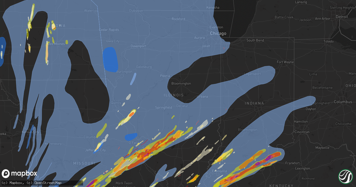
Hail Map in Illinois on March 14, 2025
Get this storm
March 14 map
$229
one time, instant access
Download today. No call, no setup
Keep the $229
Bought the map and want the full workflow? Apply the entire $229 to a subscription within 7 days. None of it is wasted.
Every map, not just this one
This buys you this map. Subscription and you get every map we run, in the markets you choose from a few cities to whole states to nationwide. Plus real-time alerts the moment a storm fires.
Contact data
Name, contact info, occupancy, even credit band for addresses in the footprint. You go from where it hit to who to call.
Become the source they trust
Unlimited branding weather history reports on demand. You already have the documented answer ready for the property owner, and you are the one who showed up with it.
Property data and RoofTrace estimates
Pull up any address you have got, its value and the exact code rules for that jurisdiction, straight from One Click Code. Then RoofTrace estimates the squares, pitch, and roof value, priced the way you price.
Storm reports in Illinois
Illinois
| Date | Description |
|---|---|
| 03/14/20253:54 PM CDT | Possible tornado. Damage to trees and powerlines and outbuildings. |
| 03/14/202511:58 AM CDT | A local report indicates 58 MPH wind near 1 SW West Chicago |
| 03/14/202511:55 AM CDT | Structural damage near cutler... Il. Roof off trailer on lincoln street and 2 barns destroyed. |
| 03/14/202511:40 AM CDT | A local report indicates 63 MPH wind near 1 SE Timberlane |
| 03/14/20252:31 AM CDT | Tree down on house in brookport. Line damage. |
| 03/14/20251:49 AM CDT | A local report indicates 1.75 inch wind near Harrisburg |
| 03/14/20251:46 AM CDT | Report from mping of half dollar |
| 03/14/20251:31 AM CDT | Severe damage to a home on gilead church road. No injuries. |
| 03/14/20251:23 AM CDT | Drone footage of multiple destroyed buildings including mobile homes along us highway 45 north of vienna near interstate 64. |
| 03/14/20251:08 AM CDT | Report from mping: half dollar |
| 03/14/202512:58 AM CDT | A few trailers flipped. |
| 03/14/202512:51 AM CDT | Delayed report. Relayed from social media. Time estimated by radar. Multiple power poles down east side of paris along us 150. |
| 03/14/202512:50 AM CDT | Trees uprooted... Structural damage to a trailer home... And a roof uplifted from a single residence home. |
| 03/14/202512:40 AM CDT | Tornado reported north of carterville. |
| 03/14/202512:36 AM CDT | Multiple trees uprooted at glen flora county club. Time estimated from radar. |
| 03/14/202512:32 AM CDT | Reported at cmi. |
| 03/14/202512:31 AM CDT | Power poles broken and powerlines down. |
| 03/14/202512:25 AM CDT | Gravestones toppled and windows blown out of the paradise baptist church and cemetery. Probably tornado damage. |
| 03/14/202512:24 AM CDT | A local report indicates 59 MPH wind near 1 NNW Antioch |
| 03/14/202512:23 AM CDT | Photo shared on social media showing multiple softwood trees damaged with some snapped in vernon hills. Time estimated from radar. |
| 03/14/202512:20 AM CDT | Large 40 foot tall 10 inch diameter pine tree snapped about 10 feet up and landed onto house. |
| 03/14/202512:20 AM CDT | Power poles and lines down. Time estimated from radar. |
| 03/14/202512:17 AM CDT | Multiple reports of trees and power poles down in du quoin. |
| 03/14/202512:15 AM CDT | Fire department responding to blown transformers... Some on fire across town. |
| 03/14/202512:15 AM CDT | Power lines down. Time estimated from radar. |
| 03/14/202512:12 AM CDT | Power poles reported down on highway 154. Time estimated from radar. |
| 03/14/202512:12 AM CDT | Peak measured wind gust. Tree also downed. |
| 03/14/202512:09 AM CDT | Report of house destroyed. |
| 03/14/202512:08 AM CDT | Outbuilding destroyed. Time estimated from radar with a radar confirmed tornado. |
| 03/14/202512:08 AM CDT | Photo shared of tree uprooted in johnsburg. Time estimated from radar. |
| 03/14/202512:04 AM CDT | Trained spotter reports part of a roof was blown off of a pole barn along button rd northeast of hebron. Time estimated by radar. |
| 03/14/202512:03 AM CDT | Six inch tree over little kinkaid rd... East of mcclure rd . |
| 03/14/202512:02 AM CDT | Semis blown over on i-57. |
| 03/14/202512:00 AM CDT | Report from social media. Porch and portion of roof torn off of home. |
| 03/14/202512:00 AM CDT | Multiple reports of uprooted or damaged trees in naperville. Time estimated from radar. |
| 03/14/202512:00 AM CDT | Trained spotter reports 6 power poles down at sr 173 and price rd in hebron. Time estimated by radar. |
| 03/13/202511:59 PM CDT | Gutters and roofing material ripped off of house... Small outbuilding demolished... Large limbs and cell tower blown down. Time estimated from radar. |
| 03/13/202511:59 PM CDT | Measured on personal weather station at west chicago esda. |
| 03/13/202511:57 PM CDT | Multiple reports of tree and fence damage in woodstock. Time estimated from radar. |
| 03/13/202511:57 PM CDT | Part of a tree snapped off on the northeast side of plainfield. Time estimated from radar. |
| 03/13/202511:56 PM CDT | Asos station kdpa west chicago - dupage arpt. |
| 03/13/202511:55 PM CDT | Measured on personal weather station. |
| 03/13/202511:53 PM CDT | Delayed report. Relayed from broadcast media. Time estimated by radar. Large 12 in tree limbs down on a house. Shingles peeled upward on roofing. |
| 03/13/202511:51 PM CDT | Fayette county ema reporting multiple lines down in vandalia. |
| 03/13/202511:49 PM CDT | Multiple areas with power lines downed across west side of aurora. |
| 03/13/202511:49 PM CDT | Large sections of siding peeled off of a large outbuilding near union. Time estimated from radar. |
| 03/13/202511:49 PM CDT | Tree down blocking road. |
| 03/13/202511:48 PM CDT | Photo shared of tree uprooted in marengo. Time estimated from radar. |
| 03/13/202511:45 PM CDT | Hail lasted for approximately 5 minutes and partially covered the road. |
| 03/13/202511:45 PM CDT | Measured on personal weather station. |
| 03/13/202511:44 PM CDT | Awos station karr 2 wnw sugar grove. |
| 03/13/202511:44 PM CDT | Tree debris on roadway. |
| 03/13/202511:44 PM CDT | Centralia esda reporting multiple power lines down. |
| 03/13/202511:42 PM CDT | Power line and tree limbs down. |
| 03/13/202511:41 PM CDT | Building damage... Wires down. |
| 03/13/202511:40 PM CDT | Barn with 2nd level torn off... Near findlay along rt 128. Delayed report. Time estimated by radar. |
| 03/13/202511:40 PM CDT | Tree in road... 20-30 feet long... 3-4 feet diameter. |
| 03/13/202511:38 PM CDT | Corrects previous tstm wnd dmg report from 4 ssw maple park. Pritchard road between perry and harter roads closed due to downed power lines. |
| 03/13/202511:37 PM CDT | Report of trees downed and building damage. |
| 03/13/202511:37 PM CDT | Tree down across road on power lines. |
| 03/13/202511:37 PM CDT | Trees reported down on road in many locations along beith road. |
| 03/13/202511:37 PM CDT | Tree downed onto wires in genoa. Time estimated from radar. |
| 03/13/202511:35 PM CDT | Tree down on power lines with a minor fire. |
| 03/13/202511:35 PM CDT | Report shared via social media of power lines downed on i-90 near south beloit. Time estimated by radar. |
| 03/13/202511:33 PM CDT | Sign damage and downed power poles near the blains farm and fleet on riverside blvd. Time estimated from radar. |
| 03/13/202511:32 PM CDT | A local report indicates 65 MPH wind near 4 NNW Hinckley |
| 03/13/202511:31 PM CDT | A local report indicates 65 MPH wind near 3 NNE Leland |
| 03/13/202511:28 PM CDT | A local report indicates 62 MPH wind near 4 NNW Winnebago |
| 03/13/202511:25 PM CDT | A local report indicates 1.25 inch wind near Altamont |
| 03/13/202511:25 PM CDT | A local report indicates 67 MPH wind near 3 W Hinckley |
| 03/13/202511:23 PM CDT | Asos station krfd rockford airport. |
| 03/13/202511:22 PM CDT | A local report indicates 1.75 inch wind near 1 S Vandalia |
| 03/13/202511:20 PM CDT | Wtvo/wqrf. |
| 03/13/202511:20 PM CDT | Delayed report. School bus barn roof was peeled off. Time estimated by radar. |
| 03/13/202511:18 PM CDT | Irvington grade school has a light pole broken at ground level. |
| 03/13/202511:13 PM CDT | Multiple power poles downed or snapped east of rochelle. Report of tree damage in the general area as well. Time estimated from radar. |
| 03/13/202511:10 PM CDT | 4 foot diameter pine tree uprooted. |
| 03/13/202511:10 PM CDT | A local report indicates 64 MPH wind near Dayton |
| 03/13/202511:10 PM CDT | A local report indicates 59 MPH wind near 1 NE Byron |
| 03/13/202511:09 PM CDT | Large tree blocking wolf road near westview road. |
| 03/13/202511:08 PM CDT | Power poles leaning at a 30 degree angle as a result of the strong thunderstorm winds. Time estimated from radar. |
| 03/13/202511:08 PM CDT | Report from mping: hen egg+ |
| 03/13/202511:07 PM CDT | House collapsed with 2 elderly occupants trapped. |
| 03/13/202511:07 PM CDT | A local report indicates 60 MPH wind near 4 NE Oregon |
| 03/13/202511:05 PM CDT | A local report indicates 1.50 inch wind near 3 SE Taylorville |
| 03/13/202511:05 PM CDT | A local report indicates 65 MPH wind near 2 SE Compton |
| 03/13/202511:04 PM CDT | A local report indicates 72 MPH wind near Ancona |
| 03/13/202511:03 PM CDT | Tree on a house with residents trapped. Residents have been freed. |
| 03/13/202511:00 PM CDT | Report from mping: quarter |
| 03/13/202511:00 PM CDT | St. Clair county em reported mobile home overturned with residents trapped inside. |
| 03/13/202510:57 PM CDT | Damage to a shed and fence. |
| 03/13/202510:55 PM CDT | Awos station kvys peru airport. |
| 03/13/202510:52 PM CDT | Large tree limbs and branches downed in polo. Time estimated from radar. |
| 03/13/202510:52 PM CDT | Possible tornado. Damage to trees and outbuildings. |
| 03/13/202510:50 PM CDT | Barn... Silos and outbuildings damaged. |
| 03/13/202510:50 PM CDT | A local report indicates 58 MPH wind near 4 WSW Troy Grove |
| 03/13/202510:47 PM CDT | St. Clair county em reported more than 20 places of power lines down in ofallon... Mascoutah... And lebanon. |
| 03/13/202510:45 PM CDT | Report from mping: golf ball |
| 03/13/202510:45 PM CDT | A local report indicates 1.00 inch wind near Shiloh |
| 03/13/202510:44 PM CDT | Ham operator reporting quarter size hail. |
| 03/13/202510:41 PM CDT | Report of mobile home destroyed. |
| 03/13/202510:40 PM CDT | A local report indicates 1.00 inch wind near 1 ESE Highland |
| 03/13/202510:39 PM CDT | Dime to quarter size hail. |
| 03/13/202510:39 PM CDT | Several power poles sheared off between hennepin and mark. 1400 customers without power. |
| 03/13/202510:38 PM CDT | Multiple buildings and silos damaged or destroyed on farm near new baden... Il. |
| 03/13/202510:38 PM CDT | Pritchard road between perry and harter roads closed due to downed power lines. |
| 03/13/202510:35 PM CDT | Numerous trees down blocking roads south of hennepin. |
| 03/13/202510:33 PM CDT | From madison county il em. |
| 03/13/202510:32 PM CDT | Siding and windows destroyed by wind driven hail. |
| 03/13/202510:31 PM CDT | Also reported quarter size hail with 1.1 inches of rain. |
| 03/13/202510:30 PM CDT | A local report indicates 1.00 inch wind near O'Fallon |
| 03/13/202510:28 PM CDT | Report from mping: quarter |
| 03/13/202510:28 PM CDT | Report from mping: quarter |
| 03/13/202510:28 PM CDT | Measured from personal weather station. Time estimated. |
| 03/13/202510:27 PM CDT | Report from mping: quarter |
| 03/13/202510:27 PM CDT | Report from mping: quarter |
| 03/13/202510:25 PM CDT | Large trees blown down on the south side of washington. |
| 03/13/202510:25 PM CDT | Large tree snapped onto house/deck. |
| 03/13/202510:25 PM CDT | A local report indicates 1.00 inch wind near O'Fallon |
| 03/13/202510:25 PM CDT | Wind driven hail resulted in extensive damage to west facing homes and buildings. |
| 03/13/202510:22 PM CDT | A local report indicates 61 MPH wind near Chillicothe |
| 03/13/202510:15 PM CDT | A grain bin was destroyed and part of a barn roof was damaged. |
| 03/13/202510:12 PM CDT | Columbia pd reported hail between quarter and golf ball size. |
| 03/13/202510:10 PM CDT | A local report indicates 1.50 inch wind near Marine |
| 03/13/202510:10 PM CDT | Damage to trees and outbuildings. |
| 03/13/202510:10 PM CDT | Report from mping: ping pong ball |
| 03/13/202510:10 PM CDT | 60 to 70 mph winds estimated from new berlin to loami. |
| 03/13/202510:08 PM CDT | Tree down. Time estimated from radar. |
| 03/13/202510:08 PM CDT | Report from mping: half dollar |
| 03/13/202510:08 PM CDT | A local report indicates 1.00 inch wind near Troy |
| 03/13/202510:07 PM CDT | Trees down. |
| 03/13/202510:07 PM CDT | Corrects previous hail report from 2 ese columbia. Columbia pd reported hail between quarter and golf ball size. |
| 03/13/202510:06 PM CDT | A local report indicates 1.00 inch wind near O'Fallon |
| 03/13/202510:06 PM CDT | Damage to trees and sheds. |
| 03/13/202510:06 PM CDT | A local report indicates 1.00 inch wind near 1 SE Glen Carbon |
| 03/13/202510:05 PM CDT | A local report indicates 1.00 inch wind near 1 ESE Troy |
| 03/13/202510:05 PM CDT | Two power poles down. |
| 03/13/202510:05 PM CDT | Possible tornado. Two mobile homes damage... One was completely rolled over. Time estimated. |
| 03/13/202510:05 PM CDT | A local report indicates 1.25 inch wind near 3 ESE Columbia |
| 03/13/202510:05 PM CDT | Report from mping: quarter |
| 03/13/202510:05 PM CDT | A local report indicates 1.00 inch wind near 2 E Glen Carbon |
| 03/13/202510:03 PM CDT | A local report indicates 1.50 inch wind near Collinsville |
| 03/13/202510:03 PM CDT | A local report indicates 1.50 inch wind near Collinsville |
| 03/13/202510:00 PM CDT | A local report indicates 1.00 inch wind near 1 ENE Glen Carbon |
| 03/13/202510:00 PM CDT | A couple trees downed by thunderstorm winds. Time estimated from radar. |
| 03/13/202510:00 PM CDT | Restaurant sign blown over. Time estimated from radar. |
| 03/13/20259:59 PM CDT | Roofing material ripped off of a large building. Time estimated from radar. |
| 03/13/20259:58 PM CDT | A large section of sturdy fencing was knocked down across from the kroger on rt 40. |
| 03/13/20259:58 PM CDT | Rotted tree snapped at its base at the peoria country club golf course. Time estimated from radar. |
| 03/13/20259:57 PM CDT | Fence and a few ill-looking trees downed by thunderstorm winds. Time estimated from radar. |
| 03/13/20259:57 PM CDT | Large but decayed tree snapped near the base. Time estimated by radar. |
| 03/13/20259:55 PM CDT | Structural damage to a home porch. |
| 03/13/20259:52 PM CDT | St. Clair county em reported a tree fell on a house on melvin drive... Injuring a 9-year old in cahokia heights. Time estimated from radar. |
| 03/13/20259:47 PM CDT | Trees down. |
| 03/13/20259:46 PM CDT | Overturned semi on the illinois side of the jb bridge. |
| 03/13/20259:41 PM CDT | A local report indicates 70 MPH wind near Cambridge |
| 03/13/20259:40 PM CDT | Metal carport blown down. Time estimated from radar. |
| 03/13/20259:39 PM CDT | Decayed tree split... Powerlines down... And pieces of roofing material blown off a couple buildings. Timing estimated from radar. |
| 03/13/20259:15 PM CDT | Reported at gbg. |
| 03/13/20259:10 PM CDT | Several tree branches were blown down and power was out for about 6 hours. |
| 03/13/20259:05 PM CDT | Sheriff department reported multiple powerlines down throughout the county. |
| 03/13/20259:04 PM CDT | Delayed report and time estimated from radar. Steeple blown off a church. |
| 03/13/20258:56 PM CDT | Estimated storm outflow gust. |
| 03/13/20258:55 PM CDT | Public report of 60 to 70 mph wind gusts. Some small branches reported down. |
| 03/13/20258:47 PM CDT | Report from mping: quarter |
| 03/13/20258:45 PM CDT | Report from mping: golf ball |
| 03/13/20258:40 PM CDT | Corrects time of occurrence for previous tstm wnd gst report from 2 e bald bluff. Estimated storm outflow gust. |
| 03/13/20258:31 PM CDT | A local report indicates 81 MPH wind near 4 SE Blandinsville |
| 03/13/20257:47 PM CDT | Large limbs down in quincy. |
All States Impacted by Hail Map on March 14, 2025
Cities Impacted by Hail Map on March 14, 2025
- Burkesville, KY
- Cable, WI
- Grand View, WI
- Ashland, WI
- Washburn, WI
- Adair, OK
- Saint Paul, AR
- McLouth, KS
- Easton, KS
- Winchester, KS
- Atchison, KS
- Rushville, MO
- Grapevine, AR
- Pickford, MI
- Osawatomie, KS
- Paola, KS
- Edgerton, KS
- Wellsville, KS
- Spring Hill, KS
- Gardner, KS
- New Century, KS
- Olathe, KS
- Barbeau, MI
- Sault Sainte Marie, MI
- Columbus, KS
- Farlington, KS
- Fort Scott, KS
- Arcadia, KS
- Garland, KS
- Deerfield, MO
- Richards, MO
- Hume, MO
- Lenexa, KS
- De Soto, KS
- Scammon, KS
- Weir, KS
- Bonner Springs, KS
- Shawnee, KS
- Pleasanton, KS
- Prescott, KS
- Mound City, KS
- Chetopa, KS
- Baxter Springs, KS
- Miami, OK
- Rich Hill, MO
- Foster, MO
- Amoret, MO
- Fulton, KS
- Butler, MO
- Amsterdam, MO
- Adrian, MO
- Louisburg, KS
- Bucyrus, KS
- Stilwell, KS
- Overland Park, KS
- Leawood, KS
- Kansas City, MO
- Prairie Village, KS
- Kansas City, KS
- La Cygne, KS
- Archie, MO
- Harrisonville, MO
- Waldron, MO
- Platte City, MO
- Nevada, MO
- Bronaugh, MO
- Moundville, MO
- Galena, KS
- Sheldon, MO
- Quapaw, OK
- Garden City, MO
- Drexel, MO
- Joplin, MO
- Liberty, MO
- Carl Junction, MO
- Anderson, MO
- Goodman, MO
- Asbury, MO
- Pittsburg, KS
- Opolis, KS
- Mindenmines, MO
- Walker, MO
- Pleasant Hill, MO
- Neosho, MO
- Greenwood, MO
- Freeman, MO
- Cleveland, MO
- Peculiar, MO
- Camden Point, MO
- Smithville, MO
- Dearborn, MO
- Edgerton, MO
- Milo, MO
- El Dorado Springs, MO
- Webb City, MO
- Carterville, MO
- Carthage, MO
- Oronogo, MO
- Jasper, MO
- Alba, MO
- Purcell, MO
- Neck City, MO
- Raymore, MO
- Lone Jack, MO
- East Lynne, MO
- Lees Summit, MO
- Diamond, MO
- Granby, MO
- Gower, MO
- Agency, MO
- Faucett, MO
- Trimble, MO
- Treece, KS
- Harwood, MO
- Picher, OK
- Schell City, MO
- Rockville, MO
- Appleton City, MO
- Riverton, KS
- Sterling, NE
- Tecumseh, NE
- Liberal, MO
- Lamar, MO
- Saint Joseph, MO
- Wathena, KS
- Amazonia, MO
- Savannah, MO
- Easton, MO
- Independence, MO
- Stewartsville, MO
- Plattsburg, MO
- Blue Springs, MO
- Oak Grove, MO
- Grain Valley, MO
- Missouri City, MO
- Excelsior Springs, MO
- Buckner, MO
- Sibley, MO
- Orrick, MO
- Creighton, MO
- Holden, MO
- Kingsville, MO
- Urich, MO
- Montrose, MO
- Humboldt, NE
- Adams, NE
- Bennet, NE
- Clinton, MO
- Pickrell, NE
- Wyandotte, OK
- Grove, OK
- Tiff City, MO
- Seneca, MO
- Reeds, MO
- Sarcoxie, MO
- Avilla, MO
- Rosendale, MO
- Fillmore, MO
- Bolckow, MO
- La Russell, MO
- Amity, MO
- Clarksdale, MO
- Maysville, MO
- Osborn, MO
- Cosby, MO
- Helena, MO
- Union Star, MO
- Lawson, MO
- Lathrop, MO
- Cameron, MO
- Holt, MO
- Turney, MO
- Kearney, MO
- Table Rock, NE
- Burr, NE
- Golden City, MO
- Jay, OK
- Cortland, NE
- Syracuse, NE
- Cook, NE
- Miller, MO
- Wellington, MO
- Bates City, MO
- Odessa, MO
- Centerview, MO
- Chilhowee, MO
- Blairstown, MO
- Osceola, MO
- Warrensburg, MO
- Deepwater, MO
- Lowry City, MO
- Lockwood, MO
- Otoe, NE
- Unadilla, NE
- South Greenfield, MO
- Greenfield, MO
- Arcola, MO
- Adair, IA
- Dadeville, MO
- Stockton, MO
- Casey, IA
- Maryville, MO
- Barnard, MO
- Skidmore, MO
- Graham, MO
- Pickering, MO
- Burlington Junction, MO
- Avoca, NE
- King City, MO
- McFall, MO
- Albany, MO
- Darlington, MO
- Stanberry, MO
- Guilford, MO
- Rea, MO
- Clyde, MO
- Murray, IA
- Peru, IA
- Lorimor, IA
- Stark City, MO
- Weatherby, MO
- Pattonsburg, MO
- Kingston, MO
- Winston, MO
- Polo, MO
- Altamont, MO
- Mayview, MO
- Lexington, MO
- Norborne, MO
- Richmond, MO
- Henrietta, MO
- Hardin, MO
- Braymer, MO
- Camden, MO
- Leeton, MO
- Windsor, MO
- Calhoun, MO
- Corder, MO
- Knob Noster, MO
- Concordia, MO
- Higginsville, MO
- Dover, MO
- Collins, MO
- Manley, NE
- Murdock, NE
- Weeping Water, NE
- Louisville, NE
- Ashland, NE
- Humansville, MO
- Plattsmouth, NE
- Murray, NE
- Springfield, NE
- Nehawka, NE
- Pacific Junction, IA
- South Bend, NE
- Greenwood, NE
- Alvo, NE
- Elmwood, NE
- Gretna, NE
- Cedar Creek, NE
- Papillion, NE
- Offutt Afb, NE
- Bellevue, NE
- Council Bluffs, IA
- Memphis, NE
- Waterloo, NE
- Omaha, NE
- Ithaca, NE
- Yutan, NE
- Everton, MO
- Wentworth, MO
- Pierce City, MO
- Gentry, AR
- Bentonville, AR
- Decatur, AR
- Siloam Springs, AR
- Cave Springs, AR
- Anita, IA
- Massena, IA
- Bridgewater, IA
- Fontanelle, IA
- Springdale, AR
- Summers, AR
- Fayetteville, AR
- Winterset, IA
- Saint Charles, IA
- Lowell, AR
- Rogers, AR
- Pea Ridge, AR
- Centerton, AR
- Bella Vista, AR
- Seligman, MO
- Garfield, AR
- Bedford, IA
- Shambaugh, IA
- Braddyville, IA
- Clearmont, MO
- Hopkins, MO
- Clarinda, IA
- Elmo, MO
- New Market, IA
- Gravity, IA
- Van Meter, IA
- Stanton, IA
- Nodaway, IA
- Villisca, IA
- Corning, IA
- Redding, IA
- Worth, MO
- Blockton, IA
- Denver, MO
- Gentry, MO
- Sheridan, MO
- Clearfield, IA
- Grant City, MO
- Benton, IA
- La Vista, NE
- Treynor, IA
- Boys Town, NE
- Elkhorn, NE
- Mead, NE
- Valley, NE
- Tingley, IA
- Afton, IA
- Shannon City, IA
- Diagonal, IA
- Mount Ayr, IA
- Lenox, IA
- Sharpsburg, IA
- Creston, IA
- Prescott, IA
- Guthrie Center, IA
- New Hampton, MO
- Brayton, IA
- Hatfield, MO
- Bethany, MO
- Martinsville, MO
- Exira, IA
- Davis City, IA
- Grand River, IA
- Mercer, MO
- Lamoni, IA
- Ellston, IA
- Gilman City, MO
- Coffey, MO
- Cainsville, MO
- Eagleville, MO
- Kellerton, IA
- Blythedale, MO
- Leon, IA
- Ridgeway, MO
- Decatur, IA
- Princeton, MO
- Chillicothe, MO
- Ludlow, MO
- Whiteman Air Force Base, MO
- Waverly, MO
- Dawn, MO
- Carrollton, MO
- Mooresville, MO
- Breckenridge, MO
- Trenton, MO
- Chula, MO
- Alma, MO
- Laredo, MO
- Utica, MO
- Spickard, MO
- Jamesport, MO
- Bogard, MO
- Tina, MO
- Washburn, MO
- Coon Rapids, IA
- Green Ridge, MO
- Sweet Springs, MO
- Cole Camp, MO
- Mora, MO
- La Monte, MO
- Ionia, MO
- Sedalia, MO
- Houstonia, MO
- Lincoln, MO
- Malta Bend, MO
- Warsaw, MO
- Hughesville, MO
- Blackburn, MO
- Edwards, MO
- Cross Timbers, MO
- Wheatland, MO
- Urbana, MO
- Preston, MO
- Hermitage, MO
- Dunnegan, MO
- Weaubleau, MO
- Quincy, MO
- Bolivar, MO
- Flemington, MO
- Pittsburg, MO
- Cassville, MO
- Exeter, MO
- Fair Play, MO
- Walnut Grove, MO
- Aldrich, MO
- De Soto, IA
- Ash Grove, MO
- Mount Vernon, MO
- Verona, MO
- Purdy, MO
- Silver City, IA
- Glenwood, IA
- Fremont, NE
- Colon, NE
- Carter Lake, IA
- Bennington, NE
- Monett, MO
- West Des Moines, IA
- Clive, IA
- Windsor Heights, IA
- Des Moines, IA
- Urbandale, IA
- Johnston, IA
- Grimes, IA
- Crane, MO
- Aurora, MO
- Marionville, MO
- Granger, IA
- Adel, IA
- Waukee, IA
- Dallas Center, IA
- Billings, MO
- Glidden, IA
- Scranton, IA
- Ralston, IA
- Churdan, IA
- Woodward, IA
- McClelland, IA
- Underwood, IA
- Minden, IA
- Shelby, IA
- Fort Calhoun, NE
- Neola, IA
- Crescent, IA
- Persia, IA
- Honey Creek, IA
- Oakland, IA
- Logan, IA
- Missouri Valley, IA
- Blair, NE
- Arlington, NE
- Washington, NE
- Kennard, NE
- De Witt, MO
- Marshall, MO
- Blackwater, MO
- Sumner, MO
- Wheeling, MO
- Keytesville, MO
- Miami, MO
- Otterville, MO
- Browning, MO
- Gilliam, MO
- Pilot Grove, MO
- Mendon, MO
- Polk, MO
- Bosworth, MO
- Triplett, MO
- Laclede, MO
- Florence, MO
- Slater, MO
- Galt, MO
- Smithton, MO
- Salisbury, MO
- Linneus, MO
- Purdin, MO
- Dalton, MO
- Nelson, MO
- Meadville, MO
- Humphreys, MO
- Brunswick, MO
- Stover, MO
- Rothville, MO
- Glasgow, MO
- Hale, MO
- Brookfield, MO
- Harris, MO
- Milan, MO
- Marceline, MO
- Lake City, IA
- Lohrville, IA
- Madrid, IA
- Orient, IA
- Allerton, IA
- Saint Marys, IA
- Garden Grove, IA
- Grant, IA
- Lineville, IA
- Truro, IA
- Humeston, IA
- Liberty Center, IA
- Powersville, MO
- Thayer, IA
- Elliott, IA
- Patterson, IA
- Osceola, IA
- Greenfield, IA
- Williamson, IA
- Seymour, IA
- Menlo, IA
- Plano, IA
- Lucas, IA
- Redfield, IA
- Prole, IA
- Marne, IA
- Carlisle, IA
- Derby, IA
- Red Oak, IA
- Millerton, IA
- Columbia, IA
- Carbon, IA
- New Virginia, IA
- Griswold, IA
- Bevington, IA
- Martensdale, IA
- Elk Horn, IA
- Ackworth, IA
- Chariton, IA
- Macksburg, IA
- Corydon, IA
- Melcher Dallas, IA
- Norwalk, IA
- Newtown, MO
- Atlantic, IA
- Cumming, IA
- Russell, IA
- Weldon, IA
- Lacona, IA
- Woodburn, IA
- Indianola, IA
- Kimballton, IA
- Stuart, IA
- Lewis, IA
- Dexter, IA
- Audubon, IA
- Earlham, IA
- Wiota, IA
- Cromwell, IA
- Milo, IA
- Lucerne, MO
- Melrose, IA
- Van Wert, IA
- Promise City, IA
- Clio, IA
- Cumberland, IA
- Lovilia, IA
- Knoxville, IA
- Pleasantville, IA
- Unionville, MO
- Ogden, IA
- Bouton, IA
- Mineola, IA
- Woodbine, IA
- Panama, IA
- Portsmouth, IA
- Dunlap, IA
- Malvern, IA
- Farragut, IA
- Henderson, IA
- Union, NE
- Carson, IA
- Macedonia, IA
- Sidney, IA
- Imogene, IA
- Shenandoah, IA
- Emerson, IA
- Randolph, IA
- Thurman, IA
- Tabor, IA
- Hastings, IA
- Essex, IA
- Harlan, IA
- Irwin, IA
- Kirkman, IA
- Booneville, IA
- Hancock, IA
- Walnut, IA
- Hamlin, IA
- New Cambria, MO
- New Franklin, MO
- Fayette, MO
- Armstrong, MO
- Arrow Rock, MO
- Clifton Hill, MO
- Bucklin, MO
- Boonville, MO
- Bunceton, MO
- Winigan, MO
- Franklin, MO
- New Boston, MO
- Ames, IA
- Boone, IA
- Bois D Arc, MO
- Republic, MO
- Fairview, MO
- Clarksburg, MO
- Higbee, MO
- Macks Creek, MO
- Climax Springs, MO
- Latham, MO
- Louisburg, MO
- Sunrise Beach, MO
- Syracuse, MO
- Gravois Mills, MO
- Versailles, MO
- Half Way, MO
- Tunas, MO
- Buffalo, MO
- Barnett, MO
- Camdenton, MO
- Rocky Mount, MO
- Fortuna, MO
- Tipton, MO
- Roach, MO
- Rockwell City, IA
- Manson, IA
- Farnhamville, IA
- Somers, IA
- Story City, IA
- Stanhope, IA
- Freistatt, MO
- Schuyler, NE
- Columbus, NE
- Leigh, NE
- Clare, IA
- Knierim, IA
- Eureka Springs, AR
- Clever, MO
- Galena, MO
- Nixa, MO
- Cape Fair, MO
- Eagle Rock, MO
- Shell Knob, MO
- Prairie City, IA
- Highlandville, MO
- Colfax, IA
- Maitland, MO
- Altoona, IA
- Runnells, IA
- Mitchellville, IA
- Otley, IA
- Newton, IA
- Swan, IA
- Pleasant Hill, IA
- Reasnor, IA
- Hartford, IA
- Monroe, IA
- Perry, IA
- Brookline, MO
- Springfield, MO
- Kelley, IA
- Gravette, AR
- Avoca, IA
- Palmer, IA
- Gilmore City, IA
- Conception Junction, MO
- Berwick, IA
- Minburn, IA
- Linden, IA
- Bondurant, IA
- Panora, IA
- Ankeny, IA
- Westside, IA
- Manilla, IA
- Manning, IA
- Lidderdale, IA
- Arcadia, IA
- Aspinwall, IA
- Wall Lake, IA
- Carroll, IA
- Vail, IA
- Breda, IA
- Halbur, IA
- Gray, IA
- Templeton, IA
- Auburn, IA
- Dedham, IA
- Strafford, MO
- Lanesboro, IA
- Fair Grove, MO
- Mingo, IA
- Jamestown, MO
- Elkhart, IA
- Harrisburg, MO
- Sheldahl, IA
- Alleman, IA
- California, MO
- Ira, IA
- Prairie Home, MO
- Baxter, IA
- Rocheport, MO
- Slater, IA
- Maxwell, IA
- Columbia, MO
- Cambridge, IA
- Huxley, IA
- Polk City, IA
- Wooldridge, MO
- Luther, IA
- Collins, IA
- Ozark, MO
- Odebolt, IA
- Dow City, IA
- Schleswig, IA
- Lytton, IA
- Defiance, IA
- Deloit, IA
- Arthur, IA
- Ida Grove, IA
- Battle Creek, IA
- Sac City, IA
- Kiron, IA
- Denison, IA
- Lake View, IA
- Elkland, MO
- Linn Creek, MO
- Eldon, MO
- Osage Beach, MO
- Lake Ozark, MO
- Russellville, MO
- Rogersville, MO
- Sparta, MO
- State Center, IA
- Nevada, IA
- Colo, IA
- Kellogg, IA
- Laurel, IA
- Rhodes, IA
- Haverhill, IA
- Melbourne, IA
- Yorktown, IA
- Marshalltown, IA
- Zearing, IA
- Blairsburg, IA
- Gilbert, IA
- Radcliffe, IA
- Saint Anthony, IA
- Jewell, IA
- Garden City, IA
- Hubbard, IA
- McCallsburg, IA
- Kamrar, IA
- Roland, IA
- Clemons, IA
- Webster City, IA
- Ellsworth, IA
- Williams, IA
- Randall, IA
- Fordland, MO
- Stratford, IA
- Albion, IA
- New Providence, IA
- Iowa Falls, IA
- Alden, IA
- Conway, MO
- Golden, MO
- Marshfield, MO
- Reeds Spring, MO
- Ponce De Leon, MO
- Phillipsburg, MO
- Montreal, MO
- Eldora, IA
- Eugene, MO
- Brumley, MO
- Kaiser, MO
- Union, IA
- Tuscumbia, MO
- Centertown, MO
- Olean, MO
- Lohman, MO
- Seymour, MO
- Oldfield, MO
- Bruner, MO
- Spokane, MO
- Long Lane, MO
- Stanton, NE
- Hartville, MO
- Dows, IA
- Fort Dodge, IA
- Clarion, IA
- Moorland, IA
- Duncombe, IA
- Vincent, IA
- Popejoy, IA
- Eagle Grove, IA
- Rowan, IA
- Lehigh, IA
- Galt, IA
- Woolstock, IA
- Walnut Shade, MO
- Chestnutridge, MO
- Early, IA
- Huntsville, MO
- Forsyth, MO
- Grovespring, MO
- Niangua, MO
- Dayton, IA
- Pilot Mound, IA
- Chadwick, MO
- Garrison, MO
- Fulton, MO
- Marquez, TX
- Auxvasse, MO
- Winside, NE
- Kingdom City, MO
- Thompson, MO
- Mexico, MO
- Norfolk, NE
- Santa Fe, MO
- Nemaha, IA
- Moberly, MO
- Ashland, MO
- Latimer, IA
- Belmond, IA
- Clark, MO
- Havelock, IA
- Hallsville, MO
- Madison, MO
- Albert City, IA
- Dakota City, IA
- Schaller, IA
- Newell, IA
- Laurens, IA
- Pocahontas, IA
- Renwick, IA
- Jolley, IA
- Alta, IA
- Storm Lake, IA
- Thor, IA
- Livermore, IA
- Holstein, IA
- Ottosen, IA
- Paris, MO
- Galva, IA
- Goldfield, IA
- Varina, IA
- Pomeroy, IA
- Rolfe, IA
- Fonda, IA
- Barnum, IA
- Rutland, IA
- Hardy, IA
- Jefferson City, MO
- Sturgeon, MO
- Humboldt, IA
- Bradgate, IA
- Centralia, MO
- New Bloomfield, MO
- Bode, IA
- Hartsburg, MO
- Badger, IA
- Henley, MO
- Kanawha, IA
- Loose Creek, MO
- Argyle, MO
- Holts Summit, MO
- Koeltztown, MO
- Iberia, MO
- Dixon, MO
- Meta, MO
- Linn, MO
- Mokane, MO
- Saint Thomas, MO
- Westphalia, MO
- Freeburg, MO
- Ulman, MO
- Chamois, MO
- Saint Elizabeth, MO
- Tebbetts, MO
- Vienna, MO
- Bonnots Mill, MO
- Mansfield, MO
- Falcon, MO
- Lebanon, MO
- Stoutland, MO
- Lynchburg, MO
- Plato, MO
- Laddonia, MO
- Rush Hill, MO
- Laquey, MO
- Richland, MO
- Waynesville, MO
- Fort Leonard Wood, MO
- Newburg, MO
- Buffalo, TX
- Oakwood, TX
- Garrison, IA
- Le Grand, IA
- Hudson, IA
- Parkersburg, IA
- Grundy Center, IA
- Van Horne, IA
- Vinton, IA
- Chelsea, IA
- Ferguson, IA
- Conrad, IA
- Lincoln, IA
- Ackley, IA
- Steamboat Rock, IA
- Hampton, IA
- Malcom, IA
- Tama, IA
- Garwin, IA
- Whitten, IA
- Morrison, IA
- Traer, IA
- Dysart, IA
- Liscomb, IA
- Keystone, IA
- Gilman, IA
- Grinnell, IA
- Belle Plaine, IA
- Wellsburg, IA
- Bradford, IA
- Buckingham, IA
- Geneva, IA
- Coulter, IA
- Aplington, IA
- Austinville, IA
- Vining, IA
- Beaman, IA
- Holland, IA
- Sheffield, IA
- Montour, IA
- Clutier, IA
- Toledo, IA
- Reinbeck, IA
- Alexander, IA
- Elberon, IA
- Gladbrook, IA
- Dike, IA
- Jewett, TX
- Ava, MO
- Mountain Grove, MO
- Perry, MO
- Armstrong, IA
- Swea City, IA
- Granada, MN
- Fairmont, MN
- Duke, MO
- Paris, AR
- Licking, MO
- Edgar Springs, MO
- Deer, AR
- Montgomery City, MO
- Williamsburg, MO
- Steedman, MO
- Scranton, AR
- Martinsburg, MO
- Gause, TX
- Milano, TX
- Cameron, TX
- Lewisville, MN
- Amboy, MN
- Truman, MN
- Hartman, AR
- Norwood, MO
- Jonesburg, MO
- Rhineland, MO
- Warrenton, MO
- Marthasville, MO
- Mount Sterling, MO
- New Florence, MO
- Berger, MO
- Bland, MO
- High Hill, MO
- Owensville, MO
- Belle, MO
- Benton City, MO
- Hermann, MO
- Morrison, MO
- Wellsville, MO
- Portland, MO
- New Haven, MO
- Truxton, MO
- New London, MO
- Curryville, MO
- Palmyra, MO
- Farber, MO
- Quincy, IL
- Stoutsville, MO
- Taylor, MO
- Frankford, MO
- Center, MO
- Hannibal, MO
- Vandalia, MO
- Monroe City, MO
- Bellflower, MO
- Maywood, MO
- Middletown, MO
- Cedar Falls, IA
- West Chester, IA
- Montezuma, IA
- Wayland, IA
- Allison, IA
- Millersburg, IA
- Greene, IA
- Blairstown, IA
- New Hartford, IA
- Chapin, IA
- Shell Rock, IA
- Rockwell, IA
- Rockford, IA
- Luzerne, IA
- Waverly, IA
- North English, IA
- Marengo, IA
- South Amana, IA
- Clarksville, IA
- Brooklyn, IA
- Bristow, IA
- Guernsey, IA
- Webster, IA
- Stout, IA
- Keota, IA
- Victor, IA
- Conroy, IA
- Parnell, IA
- Aredale, IA
- Kesley, IA
- Williamsburg, IA
- Keswick, IA
- Waterloo, IA
- Dumont, IA
- Wellman, IA
- La Porte City, IA
- Marble Rock, IA
- Deep River, IA
- Washington, IA
- Nashua, IA
- Dougherty, IA
- Harper, IA
- Brighton, IA
- South English, IA
- Janesville, IA
- Charles City, IA
- Ladora, IA
- Hartwick, IA
- Alexandria, MO
- New Sharon, IA
- Barnes City, IA
- What Cheer, IA
- Canton, MO
- La Grange, MO
- Searsboro, IA
- Plainfield, IA
- Mount Auburn, IA
- Luray, MO
- Milton, IA
- Ewing, MO
- Arbela, MO
- Libertyville, IA
- Agency, IA
- Richland, IA
- Hedrick, IA
- Ollie, IA
- Eldon, IA
- Douds, IA
- Batavia, IA
- Gibson, IA
- Fairfield, IA
- Martinsburg, IA
- Hayesville, IA
- Packwood, IA
- Cantril, IA
- Keosauqua, IA
- Mount Sterling, IA
- Selma, IA
- Raymond, IA
- Delta, IA
- Sigourney, IA
- Gilbertville, IA
- Watkins, IA
- Birmingham, IA
- Tripoli, IA
- Evansdale, IA
- Rose Hill, IA
- Readlyn, IA
- Ottumwa, IA
- Floris, IA
- Fairbank, IA
- Dewar, IA
- Jesup, IA
- Monticello, MO
- Dunkerton, IA
- Denver, IA
- Brandon, IA
- Kahoka, MO
- Newhall, IA
- Williamstown, MO
- Hull, IL
- Saint Patrick, MO
- Stockport, IA
- Bowling Green, MO
- Farmington, IA
- Bonaparte, IA
- Silex, MO
- Lewistown, MO
- Payson, IL
- Ursa, IL
- Hillsboro, IA
- Homestead, IA
- Amana, IA
- Wayland, MO
- Lockridge, IA
- Rolla, MO
- Hearne, TX
- Durham, MO
- Franklin, TX
- Crocker, MO
- Vichy, MO
- Saint Robert, MO
- Devils Elbow, MO
- Brinktown, MO
- Jerome, MO
- Beulah, MO
- Huggins, MO
- Success, MO
- Bucyrus, MO
- Graff, MO
- Roby, MO
- Fowler, IL
- Mount Pleasant, IA
- Winfield, IA
- Rowley, IA
- Argyle, IA
- Mount Union, IA
- Salem, IA
- Olds, IA
- North Liberty, IA
- Tiffin, IA
- Mendon, IL
- Ainsworth, IA
- Revere, MO
- Swisher, IA
- Nauvoo, IL
- Kalona, IA
- Solon, IA
- Fairfax, IA
- Middle Amana, IA
- Donnellson, IA
- Walker, IA
- Norway, IA
- Walford, IA
- Liberty, IL
- West Point, IA
- Cedar Rapids, IA
- Riverside, IA
- Crawfordsville, IA
- Saint Paul, IA
- Palo, IA
- Iowa City, IA
- West Point, IL
- Keokuk, IA
- Hamilton, IL
- Atkins, IA
- New London, IA
- Coralville, IA
- Warsaw, IL
- Oxford, IA
- Shellsburg, IA
- Urbana, IA
- Fort Madison, IA
- Independence, IA
- Sutter, IL
- Center Point, IA
- Montrose, IA
- Danville, IA
- Pettigrew, AR
- Parthenon, AR
- Jasper, AR
- Ponca, AR
- Clarksville, AR
- Lamar, AR
- Coal Hill, AR
- Centerville, TX
- Oark, AR
- Ozone, AR
- Yellville, AR
- Subiaco, AR
- Western Grove, AR
- Everton, AR
- Valley Springs, AR
- Vernon Center, MN
- Madelia, MN
- Morning Sun, IA
- Columbus Junction, IA
- Yarmouth, IA
- Lone Tree, IA
- Conesville, IA
- Hiawatha, IA
- Hazleton, IA
- Oelwein, IA
- Toddville, IA
- Fredericksburg, IA
- Westgate, IA
- Ionia, IA
- Sumner, IA
- New Hampton, IA
- Oran, IA
- Frederika, IA
- Hagarville, AR
- Wesco, MO
- Cook Sta, MO
- Salem, MO
- Lenox, MO
- Cherryville, MO
- Steelville, MO
- Saint James, MO
- Cuba, MO
- Leasburg, MO
- Summit, AR
- Flippin, AR
- Cotter, AR
- Mount Judea, AR
- Pelsor, AR
- Lakeview, AR
- Hasty, AR
- Gassville, AR
- Harrison, AR
- Hills, IA
- Lisbon, IA
- Paloma, IL
- Columbus City, IA
- West Burlington, IA
- Elvaston, IL
- Letts, IA
- Wever, IA
- Burlington, IA
- Mediapolis, IA
- Coggon, IA
- Carthage, IL
- Loraine, IL
- Alburnett, IA
- Quasqueton, IA
- Winthrop, IA
- West Liberty, IA
- Central City, IA
- Ely, IA
- Dallas City, IL
- Niota, IL
- Robins, IA
- Marion, IA
- Basco, IL
- Sperry, IA
- Mount Vernon, IA
- West Branch, IA
- Wapello, IA
- Denmark, IA
- Nichols, IA
- Middletown, IA
- Rosebud, MO
- Ashburn, MO
- Lomax, IL
- Gerald, MO
- Kinderhook, IL
- Bourbon, MO
- Camp Point, IL
- Leslie, MO
- Coatsburg, IL
- Sullivan, MO
- Plainville, IL
- Louisiana, MO
- Hector, AR
- Dover, AR
- Vendor, AR
- Lake Village, AR
- Dermott, AR
- Arkansas City, AR
- Midway, AR
- Mountain Home, AR
- Grapeland, TX
- Clayton, IL
- London, AR
- Crockett, TX
- Clarkridge, AR
- Saint Joe, AR
- Gainesville, MO
- Bakersfield, MO
- Udall, MO
- Beaufort, MO
- Saint Clair, MO
- Union, MO
- Russellville, AR
- Rockport, IL
- Pleasant Hill, IL
- Witts Springs, AR
- Pittsfield, IL
- Pindall, AR
- Marshall, AR
- Tilly, AR
- Leslie, AR
- Jerusalem, AR
- Huntsville, IL
- Timewell, IL
- La Prairie, IL
- Golden, IL
- Caulfield, MO
- Gamaliel, AR
- West Plains, MO
- Villa Ridge, MO
- Gray Summit, MO
- Labadie, MO
- Gepp, AR
- Lyford, TX
- Tecumseh, MO
- Pottersville, MO
- Moody, MO
- Plainview, AR
- Griggsville, IL
- Edcouch, TX
- Washington, MO
- Pacific, MO
- Wildwood, MO
- Alton, MO
- Koshkonong, MO
- Dennard, AR
- Ballwin, MO
- Chesterfield, MO
- Onia, AR
- Timbo, AR
- Clarksville, MO
- Foristell, MO
- Truesdale, MO
- Luebbering, MO
- Fletcher, MO
- Lonedell, MO
- Augusta, IL
- Saint Albans, MO
- Foley, MO
- Nebo, IL
- Barry, IL
- Bowen, IL
- Eolia, MO
- Potosi, MO
- New Canton, IL
- Moscow Mills, MO
- Richwoods, MO
- Defiance, MO
- Wentzville, MO
- Plymouth, IL
- Grubville, MO
- Baylis, IL
- La Harpe, IL
- Lake Saint Louis, MO
- Elsberry, MO
- Hawk Point, MO
- Wright City, MO
- Dittmer, MO
- Augusta, MO
- Troy, MO
- Carman, IL
- Winfield, MO
- Catawissa, MO
- Robertsville, MO
- Cedar Hill, MO
- Gladstone, IL
- Eureka, MO
- O'Fallon, MO
- Saint Charles, MO
- Annada, MO
- Saint Peters, MO
- New Salem, IL
- Old Monroe, MO
- De Soto, MO
- Arenzville, IL
- Colchester, IL
- Rushville, IL
- Frederick, IL
- Meredosia, IL
- Versailles, IL
- Bardolph, IL
- Biggsville, IL
- Chambersburg, IL
- Table Grove, IL
- Vermont, IL
- Kirkwood, IL
- Bushnell, IL
- Roseville, IL
- Raritan, IL
- Littleton, IL
- Oquawka, IL
- Hardin, IL
- Grandview, IA
- Monmouth, IL
- Mount Sterling, IL
- Fieldon, IL
- Alexis, IL
- White Hall, IL
- Macomb, IL
- Prairie City, IL
- Hillview, IL
- Aledo, IL
- Saint Augustine, IL
- Berwick, IL
- Oakville, IA
- Bluffs, IL
- Perry, IL
- Camden, IL
- Media, IL
- Seaton, IL
- Golden Eagle, IL
- Sciota, IL
- Little York, IL
- Eldred, IL
- Good Hope, IL
- Milton, IL
- Abingdon, IL
- Blandinsville, IL
- Batchtown, IL
- Kampsville, IL
- Beardstown, IL
- Keithsburg, IL
- Stronghurst, IL
- Winchester, IL
- Brussels, IL
- Avon, IL
- Smithshire, IL
- Adair, IL
- Hamburg, IL
- Gerlaw, IL
- Pearl, IL
- Industry, IL
- Tennessee, IL
- Muscatine, IA
- Cameron, IL
- Marietta, IL
- Galesburg, IL
- Clinton, AR
- Perryville, AR
- Fifty Six, AR
- Henderson, AR
- Atkins, AR
- Mountain View, AR
- House Springs, MO
- Hillsboro, MO
- Arnold, MO
- Imperial, MO
- High Ridge, MO
- Barnhart, MO
- Valley Park, MO
- Fenton, MO
- Birch Tree, MO
- Adona, AR
- Casa, AR
- Perry, AR
- Hattieville, AR
- Hot Springs National Park, AR
- Melbourne, AR
- Brockwell, AR
- Scotland, AR
- Peace Valley, MO
- Big Flat, AR
- Calico Rock, AR
- Saint Louis, MO
- Columbia, IL
- Blackwell, MO
- Festus, MO
- Royal, AR
- Millstadt, IL
- Dupo, IL
- East Carondelet, IL
- East Saint Louis, IL
- Orion, IL
- Lynn Center, IL
- Browning, IL
- Matherville, IL
- Cambridge, IL
- Alpha, IL
- Osco, IL
- Joy, IL
- North Henderson, IL
- Wataga, IL
- East Galesburg, IL
- Henderson, IL
- Rio, IL
- New Boston, IL
- Geneseo, IL
- Reynolds, IL
- Andover, IL
- Ophiem, IL
- New Windsor, IL
- Sherrard, IL
- Woodhull, IL
- Gilson, IL
- Viola, IL
- Oneida, IL
- Astoria, IL
- Cabool, MO
- Delight, AR
- Brandsville, MO
- Winona, MO
- Amity, AR
- Houston, AR
- Morrilton, AR
- Hot Springs Village, AR
- Cleveland, AR
- Center Ridge, AR
- Franklin, AR
- Violet Hill, AR
- Dow, IL
- Murrayville, IL
- Concord, IL
- Florissant, MO
- Earth City, MO
- Elsah, IL
- Ellisville, IL
- Virginia, IL
- Jacksonville, IL
- Hazelwood, MO
- London Mills, IL
- Patterson, IL
- Roodhouse, IL
- Herculaneum, MO
- Ipava, IL
- Saint Ann, MO
- Jerseyville, IL
- Maquon, IL
- Rockbridge, IL
- Grafton, IL
- Knoxville, IL
- Crystal City, MO
- Greenfield, IL
- Smithfield, IL
- Bath, IL
- Maryland Heights, MO
- Pevely, MO
- Cuba, IL
- Kane, IL
- Portage Des Sioux, MO
- Carrollton, IL
- Bridgeton, MO
- Chapin, IL
- Chandlerville, IL
- West Alton, MO
- Horseshoe Bend, AR
- Valmeyer, IL
- Waterloo, IL
- O'Fallon, IL
- Caseyville, IL
- Belleville, IL
- Fairview Heights, IL
- Bee Branch, AR
- Choctaw, AR
- Venice, IL
- Madison, IL
- Maryville, IL
- Lovejoy, IL
- Glen Carbon, IL
- Collinsville, IL
- Edwardsville, IL
- Granite City, IL
- Bismarck, AR
- Okolona, AR
- Ash Flat, AR
- Troy, IL
- Fulton, AR
- Texarkana, AR
- Edgemont, AR
- Shirley, AR
- Bigelow, AR
- Fremont, MO
- Davisville, MO
- Hope, AR
- Lebanon, IL
- Saint Jacob, IL
- Salem, AR
- Marine, IL
- Highland, IL
- Alhambra, IL
- East Alton, IL
- Worden, IL
- Sage, AR
- Wiseman, AR
- Van Buren, MO
- Ellington, MO
- New Douglas, IL
- Bunker Hill, IL
- Havana, IL
- Fairview, IL
- Godfrey, IL
- Palmyra, IL
- Chesterfield, IL
- Moro, IL
- Fidelity, IL
- Medora, IL
- Modesto, IL
- Alton, IL
- Carlinville, IL
- Bethalto, IL
- Altona, IL
- Wood River, IL
- Brighton, IL
- Alexander, IL
- Roxana, IL
- Freeburg, IL
- Piasa, IL
- Cottage Hills, IL
- Canton, IL
- Franklin, IL
- Shipman, IL
- Wrights, IL
- Hettick, IL
- Waverly, IL
- Hartford, IL
- Ashland, IL
- Dorsey, IL
- Lewistown, IL
- South Roxana, IL
- Woodson, IL
- Arkadelphia, AR
- Higden, AR
- Fairfield Bay, AR
- Gurdon, AR
- Pocahontas, IL
- Cherokee Village, AR
- Williford, AR
- Hardy, AR
- Donaldson, AR
- Malvern, AR
- Scott Air Force Base, IL
- Mascoutah, IL
- Trenton, IL
- Summerfield, IL
- Thayer, MO
- Paron, AR
- Benton, AR
- Greenville, IL
- Sorento, IL
- New Baden, IL
- Romance, AR
- Mount Vernon, AR
- Rose Bud, AR
- Little Rock, AR
- Piedmont, MO
- Cadet, MO
- Roland, AR
- Leola, AR
- Gillespie, IL
- Donnellson, IL
- Drasco, AR
- Prim, AR
- Enola, AR
- Batesville, AR
- Hillsboro, IL
- Coffeen, IL
- Ravenden, AR
- Ravenden Springs, AR
- Fillmore, IL
- Breese, IL
- Aviston, IL
- Pocahontas, AR
- Warm Springs, AR
- Emmet, AR
- Carlyle, IL
- Bingham, IL
- Witt, IL
- Raymond, IL
- Nilwood, IL
- Waggoner, IL
- Sawyerville, IL
- Oakford, IL
- Auburn, IL
- Mount Olive, IL
- Liverpool, IL
- Victoria, IL
- Staunton, IL
- Girard, IL
- Benld, IL
- Wilsonville, IL
- Yates City, IL
- Saint David, IL
- Easton, IL
- Farmington, IL
- Topeka, IL
- Bryant, IL
- Petersburg, IL
- Pleasant Plains, IL
- Kilbourne, IL
- Hamel, IL
- Litchfield, IL
- Dahinda, IL
- Virden, IL
- Tallula, IL
- Loami, IL
- Chatham, IL
- New Berlin, IL
- Cave City, AR
- Hollandale, MS
- Anguilla, MS
- Heber Springs, AR
- Chillicothe, IL
- Divernon, IL
- Creve Coeur, IL
- Peoria Heights, IL
- Morton, IL
- Laura, IL
- Chestnut, IL
- Edelstein, IL
- Sherman, IL
- Lawndale, IL
- Glasford, IL
- Mossville, IL
- Washington, IL
- Middletown, IL
- Mechanicsburg, IL
- Athens, IL
- Illiopolis, IL
- Mapleton, IL
- Williamsfield, IL
- Danvers, IL
- McLean, IL
- Brimfield, IL
- Elkhart, IL
- Forest City, IL
- East Peoria, IL
- Emden, IL
- Norris, IL
- Galva, IL
- Buffalo, IL
- Riverton, IL
- Toulon, IL
- Speer, IL
- Green Valley, IL
- Elmwood, IL
- Hartsburg, IL
- Trivoli, IL
- Armington, IL
- Rochester, IL
- Bishop Hill, IL
- Glenarm, IL
- Hopedale, IL
- Delavan, IL
- Bloomington, IL
- Heyworth, IL
- Mount Pulaski, IL
- Clinton, IL
- Mackinaw, IL
- Thayer, IL
- Springfield, IL
- Cantrall, IL
- Deer Creek, IL
- Pekin, IL
- Williamsville, IL
- Pawnee, IL
- Hanna City, IL
- Tremont, IL
- Beason, IL
- Atlanta, IL
- Waynesville, IL
- Groveland, IL
- Kenney, IL
- South Pekin, IL
- Greenview, IL
- Metamora, IL
- Manito, IL
- Dawson, IL
- Princeville, IL
- Stanford, IL
- Dunlap, IL
- Shirley, IL
- Minier, IL
- Peoria, IL
- Kewanee, IL
- Farmersville, IL
- Kingston Mines, IL
- Lincoln, IL
- San Jose, IL
- Edwards, IL
- La Fayette, IL
- Mason City, IL
- Edinburg, IL
- New Holland, IL
- Isola, MS
- Belzoni, MS
- Poughkeepsie, AR
- Smithville, AR
- Locust Grove, AR
- Marcella, AR
- Vilonia, AR
- Austin, AR
- Smithboro, IL
- Keyesport, IL
- Annapolis, MO
- Patterson, MO
- Silva, MO
- Des Arc, MO
- Ramsey, IL
- Nokomis, IL
- Evening Shade, AR
- Conway, AR
- Sherwood, AR
- Secor, IL
- Roanoke, IL
- Putnam, IL
- Henry, IL
- Bureau, IL
- Wyanet, IL
- Magnolia, IL
- Toluca, IL
- Mineral, IL
- Malden, IL
- Buda, IL
- Princeton, IL
- Lacon, IL
- Hooppole, IL
- Eureka, IL
- Carlock, IL
- Harmon, IL
- Tampico, IL
- Atkinson, IL
- Amboy, IL
- Lowpoint, IL
- Benson, IL
- Goodfield, IL
- Deer Grove, IL
- Manlius, IL
- Prophetstown, IL
- Walnut, IL
- Annawan, IL
- Congerville, IL
- McNabb, IL
- Dover, IL
- Sparland, IL
- La Moille, IL
- Minonk, IL
- Sheffield, IL
- Varna, IL
- Wyoming, IL
- Ohio, IL
- Hennepin, IL
- Granville, IL
- Bradford, IL
- New Bedford, IL
- Depue, IL
- Neponset, IL
- La Rose, IL
- Tiskilwa, IL
- Washburn, IL
- Triumph, IL
- Troy Grove, IL
- Lee, IL
- Wenona, IL
- West Brooklyn, IL
- Peru, IL
- Cedar Point, IL
- Steward, IL
- Sublette, IL
- Arlington, IL
- Standard, IL
- Oglesby, IL
- Normal, IL
- La Salle, IL
- Cherry, IL
- Compton, IL
- Rutland, IL
- Earlville, IL
- Hudson, IL
- Van Orin, IL
- Dana, IL
- Ladd, IL
- Tonica, IL
- Utica, IL
- Mendota, IL
- El Paso, IL
- Paw Paw, IL
- Mark, IL
- Dalzell, IL
- Seatonville, IL
- Lostant, IL
- Spring Valley, IL
- Streator, IL
- Mulberry Grove, IL
- Black Rock, AR
- Searcy, AR
- Lewisville, AR
- Vulcan, MO
- Vandalia, IL
- Jacksonville, AR
- Prescott, AR
- Strawberry, AR
- Maynard, AR
- Doniphan, MO
- Cabot, AR
- Grandin, MO
- Mill Spring, MO
- Ellsinore, MO
- Powhatan, AR
- Rosston, AR
- Pangburn, AR
- Judsonia, AR
- Coal Valley, IL
- Aurora, IA
- Cherry Valley, IL
- Nora, IL
- Wheatland, IA
- Madison, WI
- Avoca, WI
- Cordova, IL
- Freeport, IL
- Blackstone, IL
- Zwingle, IA
- Juda, WI
- Saint Lucas, IA
- Hazel Green, WI
- Sherrill, IA
- Harvard, IL
- Kieler, WI
- Belmont, WI
- Potosi, WI
- Argyle, WI
- Lost Nation, IA
- Orfordville, WI
- Farmersburg, IA
- Cobb, WI
- Spring Green, WI
- Carbon Cliff, IL
- Lyndon, IL
- Dyersville, IA
- Greeley, IA
- Kingston, IL
- Cortland, IL
- Castalia, IA
- Tipton, IA
- Winnebago, IL
- Sheridan, IL
- Long Point, IL
- New Liberty, IA
- Dundee, IA
- Lexington, IL
- Bennett, IA
- Wilton, IA
- Grand Ridge, IL
- Genoa, IL
- Darien, WI
- Port Byron, IL
- Sterling, IL
- Baileyville, IL
- Garnavillo, IA
- Manchester, IA
- Davis Junction, IL
- Welton, IA
- Chadwick, IL
- Bellevue, IA
- Orangeville, IL
- Mount Carroll, IL
- Milledgeville, IL
- Marquette, IA
- Goose Lake, IA
- Monroe Center, IL
- Loves Park, IL
- Arena, WI
- Saint Charles, IL
- Calamus, IA
- Marseilles, IL
- Martelle, IA
- Delmar, IA
- Benton, WI
- Grand Mound, IA
- Spragueville, IA
- Shirland, IL
- Onslow, IA
- Gratiot, WI
- Prairieburg, IA
- Boscobel, WI
- Bryant, IA
- Fruitland, IA
- Blue Grass, IA
- Patch Grove, WI
- Center Junction, IA
- McConnell, IL
- Esmond, IL
- Delaware, IA
- Stitzer, WI
- Sycamore, IL
- Apple River, IL
- Belvidere, IL
- Waukon, IA
- Lancaster, WI
- Beloit, WI
- Monroe, WI
- Chana, IL
- Leonore, IL
- Ottawa, IL
- Woodford, WI
- Andrew, IA
- Elkport, IA
- Harpers Ferry, IA
- Fenton, IL
- Shabbona, IL
- Milan, IL
- Brooklyn, WI
- Waterville, IA
- Byron, IL
- McGregor, IA
- Colesburg, IA
- Rockton, IL
- Fort Atkinson, IA
- Malta, IL
- Newark, IL
- Kirkland, IL
- Clare, IL
- Atalissa, IA
- Rewey, WI
- Bloomington, WI
- Wauzeka, WI
- Muscoda, WI
- Miles, IA
- Serena, IL
- Millbrook, IL
- Rapids City, IL
- Ossian, IA
- Colona, IL
- Thomson, IL
- Dixon, IL
- Seneca, IL
- Worthington, IA
- Hampshire, IL
- Stoughton, WI
- Ryan, IA
- Graymont, IL
- Monticello, WI
- Elgin, IA
- Scales Mound, IL
- Bernard, IA
- Dubuque, IA
- Platteville, WI
- Rock Island, IL
- Brodhead, WI
- Arlington, IA
- Belleville, WI
- Prairie Du Chien, WI
- Dickeyville, WI
- Dakota, IL
- Pecatonica, IL
- Andalusia, IL
- Sandwich, IL
- West Union, IA
- Strawberry Point, IA
- German Valley, IL
- Silvis, IL
- Fulton, IL
- Earlville, IA
- Hillsdale, IL
- Illinois City, IL
- Cascade, IA
- Avalon, WI
- Morrison, IL
- Edgewood, IA
- Dodgeville, WI
- Springville, IA
- Teeds Grove, IA
- Somonauk, IL
- Elburn, IL
- Cedarville, IL
- Franklin Grove, IL
- Mount Hope, WI
- Woosung, IL
- Moscow, IA
- Fennimore, WI
- Eastman, WI
- Guttenberg, IA
- Blue River, WI
- Millington, IL
- Rock Falls, IL
- Stanley, IA
- Hampton, IL
- Morley, IA
- Oregon, WI
- Warren, IL
- Ridott, IL
- Verona, WI
- Bagley, WI
- Clinton, WI
- Elgin, IL
- Maynard, IA
- South Wayne, WI
- La Motte, IA
- Donahue, IA
- Mount Horeb, WI
- East Dubuque, IL
- Randalia, IA
- Afton, WI
- Pearl City, IL
- East Moline, IL
- Waucoma, IA
- Galena, IL
- Lanark, IL
- Machesney Park, IL
- Albany, IL
- Black Earth, WI
- South Beloit, IL
- Cassville, WI
- Mazomanie, WI
- Richland Center, WI
- Farley, IA
- Rock City, IL
- Lena, IL
- Dixon, IA
- Lowden, IA
- Gotham, WI
- Steuben, WI
- Woodman, WI
- Mount Morris, IL
- Moline, IL
- Lawler, IA
- Clermont, IA
- New Vienna, IA
- Montfort, WI
- Epworth, IA
- Masonville, IA
- Anamosa, IA
- Montpelier, IA
- Peosta, IA
- Wyoming, IA
- Lone Rock, WI
- Gays Mills, WI
- Le Claire, IA
- Sugar Grove, IL
- Davenport, IA
- Milton, WI
- Union, IL
- Evansville, WI
- Princeton, IA
- Wadena, IA
- Garber, IA
- Browntown, WI
- Durand, IL
- Albany, WI
- Sabula, IA
- Ashton, IL
- Savanna, IL
- Lamont, IA
- Mineral Point, WI
- Rockford, IL
- Towanda, IL
- Eldena, IL
- Leland, IL
- Luana, IA
- Shullsburg, WI
- Taylor Ridge, IL
- Ransom, IL
- Marengo, IL
- Long Grove, IA
- New Glarus, WI
- Olin, IA
- Eldridge, IA
- Elizabeth, IL
- Gridley, IL
- Leaf River, IL
- Hopkinton, IA
- Forreston, IL
- Durant, IA
- McCausland, IA
- Hanover, IL
- Pleasant Valley, IA
- Hollandale, WI
- Blanchardville, WI
- Burlington, IL
- Maquoketa, IA
- Fayette, IA
- Livingston, WI
- Poplar Grove, IL
- Lindenwood, IL
- Huntley, IL
- Kent, IL
- Stillman Valley, IL
- Blue Mounds, WI
- Postville, IA
- Hinckley, IL
- Bettendorf, IA
- Durango, IA
- Holy Cross, IA
- Dekalb, IL
- Wedron, IL
- Woodstock, IL
- Buffalo, IA
- Janesville, WI
- Stockton, IA
- Cornell, IL
- Charlotte, IA
- Highland, WI
- Maple Park, IL
- Ridgeway, WI
- Footville, WI
- Monmouth, IA
- Capron, IL
- Stockton, IL
- Plano, IL
- Garden Prairie, IL
- De Witt, IA
- Walcott, IA
- Edgerton, WI
- Luxemburg, IA
- Low Moor, IA
- Glen Haven, WI
- Cross Plains, WI
- Roscoe, IL
- Ancona, IL
- Rochelle, IL
- Preston, IA
- Clarence, IA
- Pontiac, IL
- Polo, IL
- Baldwin, IA
- Holcomb, IL
- Davis, IL
- Langworthy, IA
- Delhi, IA
- Monticello, IA
- Waterman, IL
- Caledonia, IL
- Stanwood, IA
- Linden, WI
- Elkader, IA
- Mechanicsville, IA
- Sharon, WI
- Winslow, IL
- Oregon, IL
- Flanagan, IL
- Barneveld, WI
- Big Rock, IL
- Cuba City, WI
- North Buena Vista, IA
- Saint Olaf, IA
- Camanche, IA
- Darlington, WI
- Oxford Junction, IA
- Erie, IL
- Clinton, IA
- Monona, IA
- Lansing, IA
- Shannon, IL
- Volga, IA
- Hawkeye, IA
- Yorkville, IL
- Chenoa, IL
- Morris, IL
- Bristol, IL
- Aurora, IL
- Harvel, IL
- Tovey, IL
- Morrisonville, IL
- Mount Auburn, IL
- Inverness, MS
- Itta Bena, MS
- Beebe, AR
- El Paso, AR
- Smithton, IL
- Bluff City, AR
- Greenville, MO
- Lynn, AR
- Sulphur Rock, AR
- Lodi, MO
- Brownstown, IL
- Fredericktown, MO
- Beecher City, IL
- Higginson, AR
- Clubb, MO
- McRae, AR
- Saint Elmo, IL
- Kensett, AR
- Marquand, MO
- Glenallen, MO
- Kinsman, IL
- Dwight, IL
- Verona, IL
- Odell, IL
- Patton, MO
- Bald Knob, AR
- Latham, IL
- Warrensburg, IL
- Decatur, IL
- Niantic, IL
- Maroa, IL
- Sheridan, AR
- Pleasant Plains, AR
- Bradford, AR
- Oconee, IL
- Bethany, IL
- Mason, IL
- Harristown, IL
- Taylorville, IL
- Livingston, IL
- Boody, IL
- Butler, IL
- Pana, IL
- Shobonier, IL
- Taylor Springs, IL
- Owaneco, IL
- Panama, IL
- Mt Zion, IL
- Palmer, IL
- Shelbyville, IL
- Stonington, IL
- Findlay, IL
- Kincaid, IL
- Altamont, IL
- Tower Hill, IL
- Blue Mound, IL
- Ohlman, IL
- Bulpitt, IL
- Herrick, IL
- Macon, IL
- Assumption, IL
- Lakewood, IL
- Rosamond, IL
- Dalton City, IL
- Moweaqua, IL
- Forsyth, IL
- Walshville, IL
- Irving, IL
- Cowden, IL
- Newport, AR
- Sedgewickville, MO
- Tuckerman, AR
- Oil Trough, AR
- Prattsville, AR
- Sidon, MS
- Cruger, MS
- Mcfarland, WI
- Middleton, WI
- Garner, AR
- Imboden, AR
- Portia, AR
- Walnut Ridge, AR
- Redfield, AR
- Hensley, AR
- Poplar Bluff, MO
- Marble Hill, MO
- Hoxie, AR
- Chidester, AR
- Thida, AR
- Perryville, MO
- Greenwood, MS
- Harviell, MO
- Williamsville, MO
- Coila, MS
- Puxico, MO
- Wappapello, MO
- North Little Rock, AR
- Swifton, AR
- Oxly, MO
- Broseley, MO
- Fairdealing, MO
- Naylor, MO
- Dudley, MO
- Fisk, MO
- Camden, AR
- Cash, AR
- England, AR
- Friedheim, MO
- Daisy, MO
- Peach Orchard, AR
- Delaplaine, AR
- Biggers, AR
- Germantown, IL
- Stewardson, IL
- Effingham, IL
- Shumway, IL
- Augusta, AR
- Scott, AR
- Keo, AR
- Whitewater, WI
- Walworth, WI
- Carrollton, MS
- Sigel, IL
- McCrory, AR
- Hickory Ridge, AR
- Fisher, AR
- Amagon, AR
- Chester, IL
- Saint Mary, MO
- Patoka, IL
- Mode, IL
- Vernon, IL
- Sparkman, AR
- Carthage, AR
- Bono, AR
- Alicia, AR
- Fontana, WI
- Crystal Lake, IL
- Lake In The Hills, IL
- Hebron, IL
- West Chicago, IL
- Algonquin, IL
- Lake Geneva, WI
- Carpentersville, IL
- Streamwood, IL
- Cary, IL
- Plainfield, IL
- Hoffman Estates, IL
- Montgomery, IL
- Mchenry, IL
- Geneva, IL
- Dundee, IL
- Warrenville, IL
- Wayne, IL
- North Aurora, IL
- Batavia, IL
- Wasco, IL
- Bartlett, IL
- Wonder Lake, IL
- Minooka, IL
- South Elgin, IL
- Gilberts, IL
- Naperville, IL
- Williams Bay, WI
- Mooseheart, IL
- Barrington, IL
- Oswego, IL
- Delavan, WI
- Mazon, IL
- Bloomfield, MO
- Coulterville, IL
- Jacob, IL
- Rockwood, IL
- Ava, IL
- Percy, IL
- Farrar, MO
- Cutler, IL
- Walsh, IL
- Steeleville, IL
- Frohna, MO
- Sparta, IL
- Campbell Hill, IL
- Knobel, AR
- Murphysboro, IL
- Elkville, IL
- Pinckneyville, IL
- Vergennes, IL
- Du Quoin, IL
- Uniontown, MO
- Bell City, MO
- Oran, MO
- Dowell, IL
- Fordyce, AR
- Carlisle, AR
- Oak Ridge, MO
- Millersville, MO
- McCarley, MS
- Grenada, MS
- Holcomb, MS
- North Carrollton, MS
- Winona, MS
- Cambridge, WI
- Marshall, WI
- Lake Mills, WI
- Fort Atkinson, WI
- Deerfield, WI
- Cottage Grove, WI
- Waterloo, WI
- Columbus, WI
- Jefferson, WI
- Ivan, AR
- Jonesboro, AR
- Saint Peter, IL
- Bearden, AR
- Elkhorn, WI
- Eagle, WI
- Palmyra, WI
- Watertown, WI
- East Troy, WI
- Johnson Creek, WI
- Sullivan, WI
- Dousman, WI
- Mukwonago, WI
- Reeseville, WI
- Helenville, WI
- Lonoke, AR
- Pollard, AR
- Corning, AR
- Neoga, IL
- Willowbrook, IL
- Western Springs, IL
- Rolling Meadows, IL
- Broadview, IL
- Brookfield, IL
- Westchester, IL
- Trevor, WI
- Union Grove, WI
- Winnetka, IL
- Buffalo Grove, IL
- Palatine, IL
- La Grange Park, IL
- Romeoville, IL
- Maywood, IL
- Hines, IL
- Riverside, IL
- Island Lake, IL
- Wheaton, IL
- Ingleside, IL
- Berkeley, IL
- Melrose Park, IL
- Springfield, WI
- Waukegan, IL
- Richmond, IL
- Itasca, IL
- Skokie, IL
- Summit Argo, IL
- Wheeling, IL
- Round Lake, IL
- Hanover Park, IL
- Burlington, WI
- Hinsdale, IL
- Lake Forest, IL
- Mundelein, IL
- Libertyville, IL
- Northbrook, IL
- Morton Grove, IL
- Twin Lakes, WI
- Clarendon Hills, IL
- Willow Springs, IL
- Roselle, IL
- Gurnee, IL
- Franklin Park, IL
- Joliet, IL
- Salem, WI
- River Grove, IL
- Oak Park, IL
- Elk Grove Village, IL
- Winfield, IL
- Deerfield, IL
- Glen Ellyn, IL
- Chicago, IL
- Medinah, IL
- Bolingbrook, IL
- Highland Park, IL
- Spring Grove, IL
- Lake Zurich, IL
- Grayslake, IL
- Stone Park, IL
- Fox Lake, IL
- Niles, IL
- Bristol, WI
- Kansasville, WI
- Lisle, IL
- Justice, IL
- Bensenville, IL
- Lockport, IL
- Wood Dale, IL
- Berwyn, IL
- Fox River Grove, IL
- Elmwood Park, IL
- Downers Grove, IL
- Ringwood, IL
- Carol Stream, IL
- La Grange, IL
- Bridgeview, IL
- Darien, IL
- Bellwood, IL
- Hillside, IL
- Lemont, IL
- Great Lakes, IL
- Wauconda, IL
- Wilmot, WI
- Crest Hill, IL
- Hickory Hills, IL
- Lincolnshire, IL
- Schiller Park, IL
- Park Ridge, IL
- Arlington Heights, IL
- Glendale Heights, IL
- Prospect Heights, IL
- Des Plaines, IL
- Homer Glen, IL
- Palos Hills, IL
- Wadsworth, IL
- River Forest, IL
- Forest Park, IL
- Vernon Hills, IL
- Lake Villa, IL
- Glenview, IL
- Golf, IL
- Shorewood, IL
- Genoa City, WI
- Harwood Heights, IL
- Westmont, IL
- Schaumburg, IL
- Silver Lake, WI
- Elmhurst, IL
- Kenosha, WI
- Mount Prospect, IL
- Lombard, IL
- Addison, IL
- Antioch, IL
- Woodridge, IL
- North Chicago, IL
- Lake Bluff, IL
- Oak Brook, IL
- Lyons, IL
- Bloomingdale, IL
- Villa Park, IL
- Kingsland, AR
- Rison, AR
- Montrose, IL
- Toledo, IL
- Weiner, AR
- Altenburg, MO
- Old Appleton, MO
- Vanduser, MO
- Gorham, IL
- Hazen, AR
- Braidwood, IL
- New Lenox, IL
- Frankfort, IL
- Tinley Park, IL
- Wilmington, IL
- Gardner, IL
- Manhattan, IL
- Braceville, IL
- Channahon, IL
- Orland Park, IL
- Elwood, IL
- Coal City, IL
- Mokena, IL
- Palos Park, IL
- De Valls Bluff, AR
- Watson, IL
- Teutopolis, IL
- Neelyville, MO
- Sturdivant, MO
- Dexter, MO
- Bernie, MO
- Zalma, MO
- Advance, MO
- Paragould, AR
- Duck Hill, MS
- Marmaduke, AR
- Qulin, MO
- Chaffee, MO
- Scott City, MO
- Cape Girardeau, MO
- Mendenhall, MS
- Biscoe, AR
- Brownwood, MO
- Benton, MO
- Letona, AR
- Beech Grove, AR
- Stuttgart, AR
- Campbell, MO
- Wheeler, IL
- Dieterich, IL
- Jewett, IL
- Carterville, IL
- Herrin, IL
- Brinkley, AR
- Clarendon, AR
- Wheatley, AR
- Moro, AR
- Goodwin, AR
- Palestine, AR
- Lafe, AR
- Charleston, IL
- Westfield, IL
- Casey, IL
- Greenup, IL
- Lerna, IL
- Bay, AR
- Pelahatchie, MS
- Morton, MS
- De Soto, IL
- Malden, MO
- Brandon, MS
- Mattoon, IL
- Royalton, IL
- Rector, AR
- Beaver Dam, WI
- Fox Lake, WI
- Burnett, WI
- Clyman, WI
- Neosho, WI
- Iron Ridge, WI
- Waupun, WI
- Juneau, WI
- Oconomowoc, WI
- Horicon, WI
- Hustisford, WI
- Lebanon, WI
- Ixonia, WI
- Mayville, WI
- Lowell, WI
- Zion, IL
- North Prairie, WI
- Waterford, WI
- Rochester, WI
- Pleasant Prairie, WI
- Ashippun, WI
- Gore Springs, MS
- Waukesha, WI
- Hartland, WI
- Big Bend, WI
- Nashotah, WI
- Muskego, WI
- Okauchee, WI
- Delafield, WI
- Brookfield, WI
- New Berlin, WI
- Wales, WI
- Pewaukee, WI
- South Milwaukee, WI
- Elm Grove, WI
- Evanston, IL
- Winthrop Harbor, IL
- Highwood, IL
- Wilmette, IL
- Franklin, WI
- Hales Corners, WI
- Milwaukee, WI
- Evergreen Park, IL
- Burbank, IL
- Hometown, IL
- Glencoe, IL
- Midlothian, IL
- Cicero, IL
- Greendale, WI
- Saint Francis, WI
- Franksville, WI
- Oak Lawn, IL
- Alsip, IL
- Racine, WI
- Palos Heights, IL
- Oak Creek, WI
- Chicago Ridge, IL
- Lincolnwood, IL
- Worth, IL
- Crestwood, IL
- Sturtevant, WI
- Cudahy, WI
- Caledonia, WI
- Kenilworth, IL
- Edgewood, IL
- Harvey, IL
- Farina, IL
- Country Club Hills, IL
- Flossmoor, IL
- Robbins, IL
- Whiting, IN
- Hazel Crest, IL
- Homewood, IL
- Calumet City, IL
- Matteson, IL
- Blue Island, IL
- Riverdale, IL
- Posen, IL
- Alma, IL
- Markham, IL
- Hammond, IN
- South Holland, IL
- Oak Forest, IL
- Dolton, IL
- Monee, IL
- Kansas, IL
- Trilla, IL
- Humboldt, IL
- Marshall, IL
- Ashmore, IL
- Arthur, IL
- Strasburg, IL
- Lovington, IL
- Martinsville, IL
- Sullivan, IL
- Windsor, IL
- Paris, IL
- Gays, IL
- Arcola, IL
- Hammond, IL
- Dennison, IL
- Brocton, IL
- Argenta, IL
- Camargo, IL
- La Place, IL
- Tuscola, IL
- Cerro Gordo, IL
- Oakland, IL
- Hindsboro, IL
- Hidalgo, IL
- Jonesboro, IL
- Anna, IL
- Newman, IL
- Coffeeville, MS
- Big Creek, MS
- Mulkeytown, IL
- Benton, IL
- Christopher, IL
- Buckner, IL
- Hurst, IL
- Zeigler, IL
- West Frankfort, IL
- Sikeston, MO
- Essex, MO
- State University, AR
- Brookland, AR
- Lake City, AR
- Kennett, MO
- Monette, AR
- Cardwell, MO
- Arbyrd, MO
- Holcomb, MO
- Greenway, AR
- Calhoun City, MS
- Black Oak, AR
- Belle Rive, IL
- Orient, IL
- Dahlgren, IL
- Macedonia, IL
- Whittington, IL
- Ewing, IL
- Oreana, IL
- Atwood, IL
- McClure, IL
- Ullin, IL
- Thebes, IL
- Dongola, IL
- Cypress, IL
- Buncombe, IL
- Olive Branch, IL
- Vienna, IL
- Tamms, IL
- Leachville, AR
- Senath, MO
- Hornersville, MO
- Vardaman, MS
- Pittsboro, MS
- Gobler, MO
- Wardell, MO
- Portageville, MO
- Bragg City, MO
- Hayti, MO
- Steele, MO
- Bement, IL
- Union, MS
- Decatur, MS
- Gibson, MO
- Clarkton, MO
- Crown Point, IN
- Derma, MS
- Gary, IN
- Crete, IL
- Thornton, IL
- Beecher, IL
- Lansing, IL
- University Park, IL
- Munster, IN
- Dyer, IN
- Griffith, IN
- Olympia Fields, IL
- Saint John, IN
- Steger, IL
- Peotone, IL
- Richton Park, IL
- Schererville, IN
- Lowell, IN
- Chicago Heights, IL
- Cedar Lake, IN
- Glenwood, IL
- Grant Park, IL
- Manteno, IL
- Park Forest, IL
- East Chicago, IN
- Merrillville, IN
- Highland, IN
- Woodland, MS
- Houston, MS
- Gideon, MO
- Ivesdale, IL
- Sidell, IL
- Monticello, IL
- Seymour, IL
- Villa Grove, IL
- Fairmount, IL
- Potomac, IL
- Murdock, IL
- Lake Station, IN
- Redmon, IL
- Tolono, IL
- Bondville, IL
- Pesotum, IL
- Allerton, IL
- Broadlands, IL
- Fithian, IL
- Sidney, IL
- Milmine, IL
- Sadorus, IL
- Muncie, IL
- Rankin, IL
- Rantoul, IL
- Penfield, IL
- Savoy, IL
- Chrisman, IL
- White Heath, IL
- Champaign, IL
- Metcalf, IL
- Philo, IL
- Indianola, IL
- Hume, IL
- Hobart, IN
- Thomasboro, IL
- Royal, IL
- Gifford, IL
- Portage, IN
- Urbana, IL
- Homer, IL
- Armstrong, IL
- Ogden, IL
- Saint Joseph, IL
- Longview, IL
- Bertrand, MO
- Perrysville, IN
- Covington, IN
- Ridge Farm, IL
- Bismarck, IL
- Dana, IN
- Cayuga, IN
- Rossville, IL
- Catlin, IL
- Collison, IL
- Henning, IL
- Georgetown, IL
- Tilton, IL
- Westville, IL
- Oakwood, IL
- Danville, IL
- Hoopeston, IL
- Alvin, IL
- Oakland, MS
- Water Valley, MS
- Wayne City, IL
- Barnhill, IL
- Goreville, IL
- Creal Springs, IL
- Ozark, IL
- Philadelphia, MS
- McLeansboro, IL
- Tiptonville, TN
- Yorktown, AR
- Marston, MO
- Lilbourn, MO
- New Madrid, MO
- Fairfield, IL
- Mounds, IL
- Hickman, KY
- Star City, AR
- Geff, IL
- Hornbeak, TN
- Ridgely, TN
- Mount Erie, IL
- Olney, IL
- Ingraham, IL
- Clay City, IL
- Louisville, IL
- Newton, IL
- Sailor Springs, IL
- Carrier Mills, IL
- Stonefort, IL
- Harrisburg, IL
- Karnak, IL
- Villa Ridge, IL
- Olmsted, IL
- Grand Chain, IL
- Pulaski, IL
- Cairo, IL
- Belknap, IL
- Parma, MO
- Lincoln, TX
- Paige, TX
- Lexington, TX
- Dime Box, TX
- Caldwell, TX
- New Burnside, IL
- Equality, IL
- Eldorado, IL
- Somerville, TX
- Elgin, TX
- Del Valle, TX
- Bastrop, TX
- Cedar Creek, TX
- Shannon, MS
- Nettleton, MS
- Plantersville, MS
- Okolona, MS
- Randolph, MS
- Houlka, MS
- Omaha, IL
- Ridgway, IL
- Grady, AR
- Bloomingdale, IN
- Royal Center, IN
- Williamsport, IN
- Camden, IN
- Darlington, IN
- Burlington, IN
- Clinton, IN
- Templeton, IN
- Buck Creek, IN
- Russiaville, IN
- Mellott, IN
- Waynetown, IN
- Otterbein, IN
- Veedersburg, IN
- Monticello, IN
- Bringhurst, IN
- Newtown, IN
- Lafayette, IN
- Battle Ground, IN
- State Line, IN
- Ambia, IN
- Fowler, IN
- Mulberry, IN
- Flora, IN
- Kingman, IN
- Idaville, IN
- Young America, IN
- Clarks Hill, IN
- Boswell, IN
- Hillsboro, IN
- Logansport, IN
- Yeoman, IN
- Wingate, IN
- Galveston, IN
- Rossville, IN
- Brookston, IN
- Frankfort, IN
- Delphi, IN
- Forest, IN
- Attica, IN
- Westpoint, IN
- Oxford, IN
- Montezuma, IN
- Michigantown, IN
- West Lafayette, IN
- Hillsdale, IN
- Pine Village, IN
- Linden, IN
- Dayton, IN
- Burnettsville, IN
- Chalmers, IN
- Marshall, IN
- West Lebanon, IN
- Romney, IN
- New Richmond, IN
- Walton, IN
- Kokomo, IN
- Crawfordsville, IN
- Bunker Hill, IN
- Colfax, IN
- Cutler, IN
- Paducah, KY
- West Paducah, KY
- Columbus, KY
- East Prairie, MO
- Union City, TN
- Clinton, KY
- Arlington, KY
- Golden Gate, IL
- Ledbetter, KY
- Brookport, IL
- Boaz, KY
- McDade, TX
- Matthews, MO
- Catron, MO
- Kevil, KY
- Charleston, MO
- Miller City, IL
- Greentown, IN
- Simpson, IL
- Milford, IL
- Reynolds, IN
- Wellington, IL
- Remington, IN
- Wolcott, IN
- Cisne, IL
- Sumner, IL
- Parkersburg, IL
- Bone Gap, IL
- Albion, IL
- Calhoun, IL
- West Salem, IL
- Onward, IN
- Miami, IN
- Wabash, IN
- Swayzee, IN
- La Fontaine, IN
- Denver, IN
- Grissom Arb, IN
- Macy, IN
- Converse, IN
- New Waverly, IN
- North Manchester, IN
- Twelve Mile, IN
- Marion, IN
- Roann, IN
- Sweetser, IN
- Peru, IN
- Amboy, IN
- Mexico, IN
- Bryan, TX
- Fort Branch, IN
- Princeton, IN
- Columbus, MS
- Salem, KY
- Hampton, KY
- Ethelsville, AL
- Oaktown, IN
- Carlisle, IN
- Lawrenceville, IL
- Sullivan, IN
- Banner, MS
- Bruce, MS
- Golden, MS
- Fulton, MS
- Tupelo, MS
- Tremont, MS
- Giddings, TX
- College Station, TX
- Owensville, IN
- Cynthiana, IN
- Poseyville, IN
- Hazleton, IN
- Petersburg, IN
- Francisco, IN
- Patoka, IN
- Oakland City, IN
- Thompsonville, IL
- Galatia, IL
- Marion, IL
- Raleigh, IL
- Dugger, IN
- Haubstadt, IN
- Mount Carmel, IL
- Bardwell, KY
- Piggott, AR
- Ledbetter, TX
- Burna, KY
- Smithland, KY
- Tiline, KY
- Golconda, IL
- Lyons, TX
- Snook, TX
- Fancy Farm, KY
- Cunningham, KY
- Melber, KY
- Marion, KY
- Elizabethtown, IL
- Cave In Rock, IL
- Morganfield, KY
- Sturgis, KY
- Iola, TX
- Otwell, IN
- La Center, KY
- Wickliffe, KY
- Grantsburg, IL
- Vina, AL
- Montgomery, IN
- Washington, IN
- Monroe City, IN
- Winslow, IN
- Spottsville, KY
- Sebree, KY
- Chandler, IN
- Owensboro, KY
- Robards, KY
- Boonville, IN
- Calhoun, KY
- Newburgh, IN
- Corydon, KY
- Henderson, KY
- Dixon, KY
- Waverly, KY
- Reed, KY
- Tennyson, IN
- Evansville, IN
- Clay, KY
- Herod, IL
- New Haven, IL
- Junction, IL
- Mount Vernon, IN
- Shawneetown, IL
- Rosiclare, IL
- Spurgeon, IN
- Lynnville, IN
- Uniontown, KY
- Holland, IN
- Huntingburg, IN
- Velpen, IN
- Dale, IN
- New Harmony, IN
- Jasper, IN
- Elberfeld, IN
- Wadesville, IN
- Stendal, IN
- Loogootee, IN
- Cannelburg, IN
- Carrollton, AL
- Gordo, AL
- North Zulch, TX
- Madisonville, TX
- Bedias, TX
- Eddyville, IL
- Flat Rock, IL
- Hamilton, AL
- Hodges, AL
- Amory, MS
- Providence, KY
- Anderson, TX
- Crawford, MS
- Ramer, TN
- Phil Campbell, AL
- Red Bay, AL
- Russellville, AL
- Spruce Pine, AL
- Princeton, KY
- Corinth, MS
- Townley, AL
- Carbon Hill, AL
- Hickory, KY
- Grand Rivers, KY
- Calvert City, KY
- Benton, KY
- Barlow, KY
- Symsonia, KY
- Midway, TX
- Shoals, IN
- Bedford, IN
- Oolitic, IN
- Orleans, IN
- Springville, IN
- Nashville, IN
- Dubois, IN
- French Lick, IN
- Williams, IN
- Gentryville, IN
- Ferdinand, IN
- Chrisney, IN
- Celestine, IN
- Heltonville, IN
- Richland, IN
- Mitchell, IN
- Norman, IN
- Saint Anthony, IN
- West Baden Springs, IN
- Avoca, IN
- Rockport, IN
- Slaughters, KY
- Fayette, AL
- Reform, AL
- Berry, AL
- Elrod, AL
- Northport, AL
- Dundas, IL
- Carmi, IL
- Norris City, IL
- Oakman, AL
- Parrish, AL
- Jasper, AL
- English, IN
- Saint Croix, IN
- Saint Francisville, IL
- Dale, TX
- Macon, MS
- Shuqualak, MS
- Falkner, MS
- Ashland, MS
- Aliceville, AL
- Walnut, MS
- Michie, TN
- Pontotoc, MS
- Metropolis, IL
- Holly Springs, MS
- Paoli, IN
- Santa Claus, IN
- Freetown, IN
- Campbellsburg, IN
- Tell City, IN
- Edinburgh, IN
- Nineveh, IN
- Bristow, IN
- Fredericksburg, IN
- Birdseye, IN
- Franklin, IN
- Evanston, IN
- Vallonia, IN
- Ramsey, IN
- Leopold, IN
- Hardinsburg, IN
- Grandview, IN
- Lincoln City, IN
- Seymour, IN
- Tunnelton, IN
- Branchville, IN
- Schnellville, IN
- Salem, IN
- Leavenworth, IN
- Lamar, IN
- Grantsburg, IN
- Saint Meinrad, IN
- Milltown, IN
- Depauw, IN
- Marengo, IN
- Columbus, IN
- Eckerty, IN
- Taswell, IN
- Medora, IN
- Sulphur, IN
- Brownstown, IN
- Fredonia, KY
- Haleyville, AL
- Bear Creek, AL
- Hackleburg, AL
- Utica, KY
- Jacksonville, TX
- Rusk, TX
- Troy, IN
- Maceo, KY
- Philpot, KY
- Lewisport, KY
- Adamsville, TN
- Shiloh, TN
- Selmer, TN
- Stantonville, TN
- Savannah, TN
- Hanson, KY
- Rumsey, KY
- Westport, IN
- Greensburg, IN
- Saint Paul, IN
- Madison, IN
- Palmyra, IN
- Hartsville, IN
- Sunman, IN
- Butlerville, IN
- Manilla, IN
- Shelbyville, IN
- Crothersville, IN
- Jonesville, IN
- Paris Crossing, IN
- Milroy, IN
- Taylorsville, IN
- Batesville, IN
- Grammer, IN
- New Salisbury, IN
- Elizabethtown, IN
- Vernon, IN
- Commiskey, IN
- Waldron, IN
- Clifford, IN
- Scipio, IN
- Osgood, IN
- North Vernon, IN
- Austin, IN
- Milan, IN
- Cross Plains, IN
- Napoleon, IN
- Dillsboro, IN
- Flat Rock, IN
- Versailles, IN
- Holton, IN
- Hope, IN
- Pekin, IN
- Scottsburg, IN
- Kennard, TX
- Alto, TX
- Wells, TX
- Douglass, TX
- Hawesville, KY
- Shreveport, LA
- Greenwood, LA
- Mooringsport, LA
- Blanchard, LA
- Cushing, TX
- Nacogdoches, TX
- Garrison, TX
- Long Branch, TX
- Carthage, TX
- Reynolds Station, KY
- Cloverport, KY
- Whitesville, KY
- Payneville, KY
- Rome, IN
- Hardinsburg, KY
- Cannelton, IN
- Union Star, KY
- Stephensport, KY
- Derby, IN
- Underwood, IN
- Borden, IN
- Henryville, IN
- Battletown, KY
- Corydon, IN
- Mauckport, IN
- Rhodelia, KY
- Central, IN
- Belcher, LA
- Benton, LA
- Georgetown, IN
- Lanesville, IN
- Floyds Knobs, IN
- New Albany, IN
- Laconia, IN
- Guston, KY
- Webster, KY
- Brandenburg, KY
- Nebo, KY
- Harned, KY
- Irvington, KY
- Dupont, IN
- Sacramento, KY
- Madisonville, KY
- Manitou, KY
- Crandall, IN
- Greenville, IN
- Deputy, IN
- De Berry, TX
- Elizabeth, IN
- Sellersburg, IN
- Louisville, KY
- Clarksville, IN
- Jeffersonville, IN
- Crestwood, KY
- La Grange, KY
- Goshen, KY
- Prospect, KY
- Westport, KY
- Charlestown, IN
- Warren, IN
- Servia, IN
- Huntington, IN
- Urbana, IN
- Andrews, IN
- Lagro, IN
- Lexington, IN
- Hanover, IN
- Otisco, IN
- Memphis, IN
- Nabb, IN
- Marysville, IN
- Pendleton, KY
- Smithfield, KY
- Bedford, KY
- Sulphur, KY
- New Middletown, IN
- Ekron, KY
- Milton, KY
- Glenview, KY
- Masonic Home, KY
- New Washington, IN
- Bethlehem, IN
- Fairdale, KY
- Shelbyville, KY
- Buckner, KY
- Pewee Valley, KY
- Simpsonville, KY
- Shongaloo, LA
- Sarepta, LA
- Emerson, AR
- Cotton Valley, LA
- Boston, IN
- Homer, IN
- New Paris, OH
- Richmond, IN
- West Manchester, OH
- Arlington, IN
- Christiansburg, OH
- New Carlisle, OH
- Piqua, OH
- Webster, IN
- Clayton, OH
- Saint Paris, OH
- Falmouth, IN
- Laura, OH
- Eldorado, OH
- Connersville, IN
- Brookville, OH
- Englewood, OH
- Pitsburg, OH
- Conover, OH
- Centerville, IN
- Troy, OH
- Verona, OH
- Dayton, OH
- Phillipsburg, OH
- Brownsville, IN
- Rushville, IN
- Pleasant Hill, OH
- Tipp City, OH
- Arcanum, OH
- Bradford, OH
- Turners Station, KY
- New Madison, OH
- Glenwood, IN
- Milton, IN
- New Castle, KY
- Greenville, OH
- Campbellsburg, KY
- Hollansburg, OH
- Covington, OH
- Eaton, OH
- West Alexandria, OH
- Brookville, IN
- Metamora, IN
- Cambridge City, IN
- Greens Fork, IN
- Lewisburg, OH
- Liberty, IN
- Fletcher, OH
- Ludlow Falls, OH
- Casstown, OH
- Laurel, IN
- Oldenburg, IN
- Vandalia, OH
- Eminence, KY
- West Milton, OH
- Karnack, TX
- Jefferson, TX
- Bivins, TX
- Magnolia, AR
- Tucker, AR
- Des Arc, AR
- Cotton Plant, AR
- Batesville, MS
- Courtland, MS
- Leland, MS
- Shaw, MS
- Boyle, MS
- Cleveland, MS
- Montrose, AR
- Hamburg, AR
- Vernon, AL
- Winfield, AL
- Cullman, AL
- Hanceville, AL
- Bossier City, LA
- Jones, LA
- Wilmot, AR
- Courtland, AL
- Hillsboro, AL
- Moulton, AL
- Warrior, AL
- Kennedy, AL
- Natchitoches, LA
- Cordova, AL
- Potts Camp, MS
- Senatobia, MS
- Como, MS
- Crossett, AR
- Huttig, AR
- Marion, LA
- Bremen, AL
- Crane Hill, AL
- Marshall, TX
- Waskom, TX
- Rohwer, AR
- McGehee, AR
- Greenville, MS
- Rockville, IN
- Thorntown, IN
- Waveland, IN
- New Ross, IN
- New Market, IN
- Alamo, IN
- Oxford, OH
- Camden, OH
- West College Corner, IN
- College Corner, OH
- Cedar Grove, IN
- New Lebanon, OH
- Germantown, OH
- Bath, IN
- West Harrison, IN
- Hamilton, OH
- Farmersville, OH
- Somerville, OH
- Coldwater, MS
- Brooksville, MS
- Byhalia, MS
- Millport, AL
- Lovelady, TX
- Bankston, AL
- Goldonna, LA
- Locust Fork, AL
- Kimberly, AL
- Cleveland, AL
- Gardendale, AL
- Hayden, AL
- Trafford, AL
- Holly Pond, AL
- Willard, OH
- Springhill, LA
- Plain Dealing, LA
- Guys, TN
- Bethany, LA
- Watson, AR
- Portland, AR
- Counce, TN
- Chatham, LA
- Sterlington, LA
- Farmerville, LA
- Bastrop, LA
- Henderson, TX
- Berlin Heights, OH
- Milan, OH
- Dora, AL
- Quitman, LA
- Downsville, LA
- Arab, AL
- Baileyton, AL
- Joppa, AL
- Eros, LA
- West Monroe, LA
- Union Grove, AL
- Blountsville, AL
- Eva, AL
- Somerville, AL
- Eldridge, AL
- Albertville, AL
- Horton, AL
- Blanchester, OH
- Tillar, AR
- West Point, KY
- Quinton, AL
- Bessemer, AL
- Enville, TN
- Laneville, TX
- Mount Enterprise, TX
- Coshocton, OH
- Birch Run, MI
- Nauvoo, AL
- Moscow, TN
- Ellery, IL
- Williamsburg, OH
- Fayetteville, OH
- Colt, AR
- Monticello, AR
- Natchez, LA
- Robeline, LA
- Jonesboro, LA
- Provencal, LA
- Marks, MS
- Pocahontas, TN
- Echola, AL
- Huron, OH
- Vermilion, OH
- Choudrant, LA
- Fisherville, KY
- Mayfield, KY
- Winnfield, LA
- Parkdale, AR
- Taylor, AR
- Ellettsville, IN
- Gosport, IN
- Fairfield, TX
- Somerville, TN
- Grand Junction, TN
- New Vienna, OH
- Martinsville, OH
- Edison, OH
- Cardington, OH
- Marion, OH
- Caledonia, OH
- Leona, TX
- Benoit, MS
- Calhoun, LA
- Adger, AL
- Tuscaloosa, AL
- Buhl, AL
- Coker, AL
- Universal, IN
- New Goshen, IN
- Rosedale, IN
- Mecca, IN
- Vermilion, IL
- West Terre Haute, IN
- Creston, NE
- Bloomington, IN
- Odon, IN
- Crane, IN
- Bloomfield, IN
- Plainville, IN
- Owensburg, IN
- Scotland, IN
- Newberry, IN
- Solsberry, IN
- Wheatland, IN
- Elnora, IN
- Trafalgar, IN
- Morgantown, IN
- Bargersville, IN
- Unionville, IN
- Martinsville, IN
- Greenfield, IN
- Gwynneville, IN
- Fairland, IN
- Needham, IN
- Carthage, IN
- Morristown, IN
- Whiteland, IN
- Fountaintown, IN
- Boggstown, IN
- Straughn, IN
- Williamsburg, IN
- Knightstown, IN
- Mays, IN
- Lewisville, IN
- Fountain City, IN
- Earling, IA
- College Springs, IA
- Charter Oak, IA
- Arion, IA
- Mount Hope, AL


