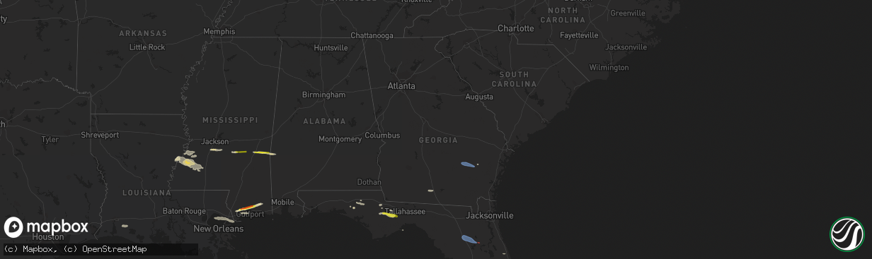
Hail Map in Georgia on March 12, 2023
The weather event in Georgia on March 12, 2023 includes Wind, Hail, and Tornado maps. 6 states and 88 cities were impacted and suffered possible damage. The total estimated number of properties impacted is 0.
Want more than just the map?
Turn this storm into a full workflow.
- Owner + property data so you know who to knock
- OnDemand branded weather history reports to win the "did we even have hail?" argument
- RoofTrace estimate so reps stop guessing numbers at the door
Bought this map? Upgrade within 7 days and we'll credit the $230. (10-15 min setup call)
Wind
Hail
Tornado
0
Estimated number of impacted properties by a 1.00" hail or larger0
Estimated number of impacted properties by a 1.75" hail or larger0
Estimated number of impacted properties by a 2.50" hail or largerStorm reports in Georgia
Georgia
| Date | Description |
|---|---|
| 03/12/20232:15 PM CDT | Awos station kbhc baxley muni. |
| 03/12/20232:15 PM CDT | Appling county em reports doors blown off their hinges at the baxley municipal airport hangers and airplanes. Time estimated by awos kbhc gust timing. |
| 03/12/20231:50 PM CDT | Thomas co 911 reports a tree down across hwy 33 at woodhaven rd. |
| 03/12/20231:35 PM CDT | Colquitt co 911 reports a cable line down on talmadge dt. |
| 03/12/20231:12 PM CDT | Mitchell co 911 reports a tree down on glausier st. |
| 03/12/20231:10 PM CDT | Mitchell co 911 reports a power line down on hwy 93. |
| 03/12/20231:07 PM CDT | Trees down on railroad street. Time estimated by radar. |
| 03/12/20231:02 PM CDT | Tree down on stagecoach road. Time estimated by radar. |
| 03/12/202311:15 AM CDT | Lee county 911 reports a tree down on pettis rd. |
All States Impacted by Hail Map on March 12, 2023
Cities Impacted by Hail Map on March 12, 2023
- Union Church, MS
- Port Gibson, MS
- Hermanville, MS
- Pattison, MS
- Lorman, MS
- Waterproof, LA
- McCall Creek, MS
- Brookhaven, MS
- Fayette, MS
- Saint Joseph, LA
- Natchez, MS
- Meadville, MS
- Wesson, MS
- Baxley, GA
- Alma, GA
- Surrency, GA
- Odum, GA
- Hosford, FL
- Sopchoppy, FL
- Tallahassee, FL
- Telogia, FL
- Bristol, FL
- Ponce De Leon, FL
- Raleigh, MS
- Vernon, FL
- Chipley, FL
- Florence, MS
- Terry, MS
- Mize, MS
- Braxton, MS
- Caryville, FL
- Hahira, GA
- Barney, GA
- Morven, GA
- Crystal Springs, MS
- Grand Ridge, FL
- Dos Palos, CA
- Firebaugh, CA
- Madera, CA
- Taylorsville, MS
- Bay Springs, MS
- Louin, MS
- Pachuta, MS
- Quitman, MS
- Shubuta, MS
- Kerman, CA
- Fresno, CA
- Biola, CA
- Selma, CA
- Fowler, CA
- Kingsburg, CA
- Dinuba, CA
- Kiln, MS
- Pass Christian, MS
- Gulfport, MS
- Saucier, MS
- Traver, CA
- Chowchilla, CA
- Bonifay, FL
- Gilbertown, AL
- Needham, AL
- Harrisville, MS
- Pinola, MS
- Georgetown, MS
- Melvin, AL
- Altha, FL
- Magee, MS
- Toxey, AL
- Lacombe, LA
- Laurel, MS
- Paulding, MS
- Vossburg, MS
- Quincy, FL
- Bell City, LA
- Cameron, LA
- Lacassine, LA
- New Orleans, LA
- Slidell, LA
- Biloxi, MS
- Diamondhead, MS
- Long Beach, MS
- Vancleave, MS
- Panacea, FL
- Holt, FL
- Alachua, FL
- Gainesville, FL
- Hawthorne, FL
- Ormond Beach, FL


