Hail Map in Fort Worth, TX on March 8, 2016
The weather event in Fort Worth, TX on March 8, 2016 includes Hail map. 4 states and 252 cities were impacted and suffered possible damage. The total estimated number of properties impacted is 38,830.
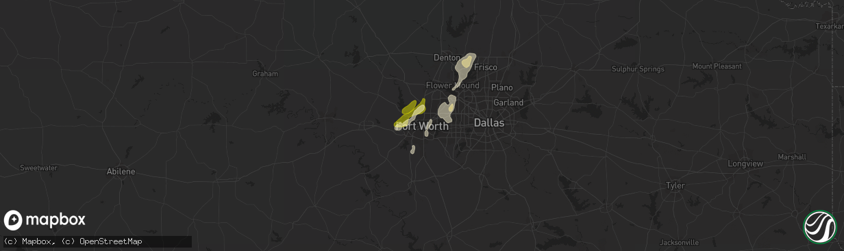
Hail
38,830
Estimated number of impacted properties by a 1.00" hail or larger0
Estimated number of impacted properties by a 1.75" hail or larger0
Estimated number of impacted properties by a 2.50" hail or largerStorm reports in Fort Worth, TX
Fort Worth, TX
| Date | Description |
|---|---|
| 03/08/20168:53 AM CST | Large branches down on rufe snow drive sidewalk. |
| 03/08/20168:18 AM CST | Roof blown off of a business at saginaw-main near 820 in the city of saginaw. Time estimated via radar. |
| 03/08/20168:15 AM CST | Delayed report - damage to campus building at tcc northwest. Time is radar estimated. |
| 03/08/20168:15 AM CST | Estimated 70mph winds with quarter sized hail in saginaw. |
| 03/08/20168:15 AM CST | Several large trees snapped at the mira vista golf course. Largest tree was 36 inches in diameter. Total of 25 trees uprooted. |
| 03/08/20168:15 AM CST | Delayed report - damage to campus building at tcc northwest. Time is radar estimated. |
| 03/08/20168:14 AM CST | Measured 66 mph wind gust at fort worth joint reserve base |
| 03/08/20168:13 AM CST | Damage to siding at a service station at blue mound road. Time estimated via radar. |
| 03/08/20168:13 AM CST | Delayed report---damage to small shed near verizon store just north of 820 in lake worth. Time estimated via radar. |
| 03/08/20168:05 AM CST | Delayed report - damage to benbrook marina relayed via twitter |
| 03/08/20168:05 AM CST | Dozens of boats damaged at benbrook lake marina. Picnic tables blown into lake. Boat masts wrapped around poles. |
| 03/08/20167:55 AM CST | Delayed report - heavy rain and nickel size hail along with winds estimated at 65 mph. Report from former nws employee. |
All Cities Impacted by Hail Map on March 8, 2016
- Hibbing, MN
- Lampasas, TX
- Frisco, TX
- Aubrey, TX
- Prosper, TX
- Flower Mound, TX
- Denton, TX
- Lake Dallas, TX
- Little Elm, TX
- Lewisville, TX
- Sulphur, LA
- Westlake, LA
- Lake Charles, LA
- Fort Worth, TX
- San Antonio, TX
- Jacksonville, TX
- Uvalde, TX
- Brimson, MN
- Weatherford, TX
- Big Wells, TX
- Camp Wood, TX
- Franklin, TX
- Haltom City, TX
- Jacksboro, TX
- Bridgeport, TX
- Provencal, LA
- Robeline, LA
- Natchez, LA
- Natchitoches, LA
- Florien, LA
- Woodsboro, TX
- New Braunfels, TX
- Seguin, TX
- San Marcos, TX
- Kingsbury, TX
- Laredo, TX
- Smiley, TX
- Crystal City, TX
- Stephenville, TX
- Dublin, TX
- Isabella, MN
- Waynoka, OK
- Brady, TX
- Mason, TX
- Voca, TX
- Lorena, TX
- Chilton, TX
- Crowley, TX
- Joshua, TX
- Hamilton, TX
- Harper, TX
- Goldthwaite, TX
- Aledo, TX
- Jonesboro, TX
- Star, TX
- Purmela, TX
- Lometa, TX
- Evant, TX
- Menard, TX
- Fort McKavett, TX
- Ozona, TX
- San Saba, TX
- Hext, TX
- Fredonia, TX
- Mcallen, TX
- Mission, TX
- Sonora, TX
- Gatesville, TX
- Valley Mills, TX
- Rio Grande City, TX
- Tow, TX
- Bluffton, TX
- Comstock, TX
- Del Rio, TX
- Jbsa Ft Sam Houston, TX
- Montgomery, TX
- Sentinel, OK
- Mountain Park, OK
- Pearsall, TX
- Rocksprings, TX
- Pontotoc, TX
- London, TX
- Richland Springs, TX
- Cherokee, TX
- Valley Spring, TX
- Rochelle, TX
- Buda, TX
- Kyle, TX
- Nemo, TX
- Paradise, TX
- Mullin, TX
- Mountain Home, TX
- Junction, TX
- Leakey, TX
- Hunt, TX
- Barksdale, TX
- Dequincy, LA
- Vinton, LA
- Dilley, TX
- Roma, TX
- Eden, TX
- Asherton, TX
- Henderson, TX
- Leander, TX
- Liberty Hill, TX
- Brookeland, TX
- Hondo, TX
- Huntsville, TX
- New Waverly, TX
- Poolville, TX
- Perrin, TX
- Big Spring, TX
- Coahoma, TX
- Mountain Iron, MN
- Kinney, MN
- Palestine, TX
- Walnut Springs, TX
- Iredell, TX
- Zephyr, TX
- Glen Rose, TX
- Sterling City, TX
- Llano, TX
- Dodson, LA
- Cotulla, TX
- Maxwell, TX
- Caldwell, TX
- Batesville, TX
- Natalia, TX
- Babbitt, MN
- Carrizo Springs, TX
- Bertram, TX
- Eros, LA
- Chatham, LA
- Winnie, TX
- Gonzales, TX
- Hico, TX
- Morgan, TX
- Meridian, TX
- Kopperl, TX
- Atascosa, TX
- Lytle, TX
- San Ygnacio, TX
- Lawn, TX
- Tuscola, TX
- Ovalo, TX
- Sabinal, TX
- Buffalo Gap, TX
- Abilene, TX
- Edinburg, TX
- Brackettville, TX
- Pottsville, TX
- Burnet, TX
- Bend, TX
- Buchanan Dam, TX
- Concan, TX
- Knippa, TX
- Brazoria, TX
- Boerne, TX
- Westbrook, TX
- Mertzon, TX
- Boling, TX
- Pledger, TX
- De Leon, TX
- Poteet, TX
- Marble Falls, TX
- Pollok, TX
- Alto, TX
- Wells, TX
- Bigfoot, TX
- Cedar Creek, TX
- Apple Springs, TX
- Cleburne, TX
- Granbury, TX
- Comanche, TX
- Floydada, TX
- Roosevelt, OK
- Giddings, TX
- Converse, TX
- Lake Providence, LA
- Naval Air Station Jrb, TX
- Universal City, TX
- Schertz, TX
- Von Ormy, TX
- Jbsa Lackland, TX
- Jbsa Randolph, TX
- Crawford, TX
- Rio Frio, TX
- Wortham, TX
- Bedford, TX
- Euless, TX
- Dallas, TX
- Colleyville, TX
- Grapevine, TX
- Salado, TX
- Buffalo, TX
- Jonesboro, LA
- Celina, TX
- Buhl, MN
- Somerset, TX
- Pipe Creek, TX
- Plainview, TX
- Linn, TX
- Roosevelt, TX
- Georgetown, TX
- Florence, TX
- Frankston, TX
- Goldonna, LA
- Winnfield, LA
- Catarina, TX
- Many, LA
- Arlington, TX
- North Richland Hills, TX
- Hurst, TX
- Southlake, TX
- Jasper, TX
- La Pryor, TX
- Arapaho, OK
- Weatherford, OK
- Mora, LA
- Bluff Dale, TX
- Novice, TX
- Goldsboro, TX
- Lena, LA
- Carnegie, OK
- Sweeny, TX
- Hominy, OK
- Fort Cobb, OK
- Rusk, TX
- Waelder, TX
- Reklaw, TX
- Laneville, TX
- Lipan, TX
- Blanket, TX
- Victoria, TX
- Chico, TX
- Briggs, TX
- Saint Hedwig, TX
- Littlefork, MN
- Hidalgo, TX
- Pharr, TX
- Austin, TX
- Refugio, TX
- Kempner, TX
- Eldorado, TX
- West Monroe, LA
- Centerville, TX
- Athens, TX
- Waller, TX
- Plantersville, TX
- Port Lavaca, TX
- Haslet, TX
- Keller, TX


