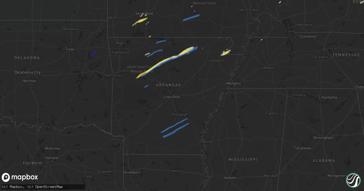
Hail Map in Arkansas on March 6, 2022
Get this storm
March 6 map
$229
one time, instant access
Download today. No call, no setup
Keep the $229
Bought the map and want the full workflow? Apply the entire $229 to a subscription within 7 days. None of it is wasted.
Every map, not just this one
This buys you this map. Subscription and you get every map we run, in the markets you choose from a few cities to whole states to nationwide. Plus real-time alerts the moment a storm fires.
Contact data
Name, contact info, occupancy, even credit band for addresses in the footprint. You go from where it hit to who to call.
Become the source they trust
Unlimited branding weather history reports on demand. You already have the documented answer ready for the property owner, and you are the one who showed up with it.
Property data and RoofTrace estimates
Pull up any address you have got, its value and the exact code rules for that jurisdiction, straight from One Click Code. Then RoofTrace estimates the squares, pitch, and roof value, priced the way you price.
Storm reports in Arkansas
Arkansas
| Date | Description |
|---|---|
| 03/06/20225:24 PM CST | Trees fell on a home on walnut valley road and on a home on sara page road. There were no injuries reported. |
| 03/06/20225:23 PM CST | Tornado video posted on social media west of hector. Trees were down and damage reported at the martin township fire department. |
| 03/06/20225:21 PM CST | Trees down from a confirmed tornado near the rushing road area approximately 3 miles north of dover... Ar. |
| 03/06/20224:03 PM CST | Funnel or possible tornado located 13 miles southeast of bono ar... Northeast at 35 mph. |
| 03/06/20223:50 PM CST | Metal shed destroyed near the intersection of pitts road and long creek ln. |
| 03/06/20224:31 AM CST | At 1031 PM CST, severe thunderstorms were located along a line extending from 8 miles southwest of Culp to 7 miles west of Mountain View to Old Lexington, moving east at 60 mph. HAZARD...60 mph wind gusts. SOURCE...Radar indicated. IMPACT...Expect damage to roofs, siding, and trees. Locations impacted include... Mountain View... Melbourne... Calico Rock... Oxford... Mount Pleasant... Pineville... Franklin... Lone Star... Wideman... Gid... Herpel... Lunenburg... Culp... Blanchard Springs Campground... Thola... Brandenberg... Croker... Gorby... Stella... Old Lexington... |
| 03/06/20224:25 AM CST | At 1025 PM CST, a severe thunderstorm was located over Plainview in Yell County, or near Danville, moving northeast at 60 mph. HAZARD...60 mph wind gusts. SOURCE...Radar indicated. IMPACT...Expect damage to roofs, siding, and trees. Locations impacted include... Russellville... Danville... Dardanelle... Atkins... Pottsville... Ola... Adona... Carden Bottoms... Happy Bend... Petit Jean State Park... Plainview in Yell County... Petit Jean River WMA... Galla Creek WMA... Mosley... Belleville... Casa... Aplin... Corinth... Birta... Ada...This includes Interstate 40 between mile markers 86 and 99. |
| 03/06/20224:05 AM CST | At 1005 PM CST, severe thunderstorms were located along a line extending from near Kay to near Woolum to 6 miles north of Jerusalem, moving east at 55 mph. HAZARD...60 mph wind gusts and quarter size hail. SOURCE...Radar indicated. IMPACT...Hail damage to vehicles is expected. Expect wind damage to roofs, siding, and trees. Locations impacted include... Clinton... Fairfield Bay... Marshall... Hector... Shirley... Marsena... Witts Spring... Rocky Hill... Dabney... Bohannon... Sugar Loaf Recreation Area... Imo... Elberta... Watts... Thola... Kay... Fairfield Bay Marina... Claude... Elba... Woolum... |
| 03/06/20223:52 AM CST | At 952 PM CST, a severe thunderstorm was located 9 miles southwest of Gravelly, or 16 miles southeast of Waldron, moving east at 55 mph. HAZARD...60 mph wind gusts and quarter size hail. SOURCE...Radar indicated. IMPACT...Hail damage to vehicles is expected. Expect wind damage to roofs, siding, and trees. Locations impacted include... Danville... Cardiff... Gravelly... Fourche Valley... Muddy Creek WMA... Plainview in Yell County... Belleville... Corinth... Ranger... Wing... Olio... Kingston... Bluffton... Rover... Blue Ball... Union Hill... Chula... Macedonia in Yell County... Cedar Creek... Waltreak... |
| 03/06/20222:56 AM CST | At 855 PM CST, a severe thunderstorm was located over Beauchamp, or 10 miles southwest of Waldron, moving northeast at 60 mph. HAZARD...60 mph wind gusts and nickel size hail. SOURCE...Radar indicated. IMPACT...Expect damage to roofs, siding, and trees. Locations impacted include... Waldron... Beauchamp... Cardiff... Oliver... Morgan Springs... Bates... Cauthron... Winfield... Olio... Hon... Cedar Creek... Needmore... Harvey... Boles... Parks... Grayson... Y City... |
| 03/06/20222:55 AM CST | Corrects previous tstm wnd dmg report from 4 wsw lexa. Three power poles were knocked down on highway 316 one mile north of highway 49. One tree was also knocked down a |
| 03/06/20222:55 AM CST | Five power poles were knocked down on highway 316 one mile north of highway 49. |
| 03/06/20222:43 AM CST | At 843 PM CST, a severe thunderstorm was located 6 miles northeast of Fern, moving northeast at 55 mph. HAZARD...60 mph wind gusts and half dollar size hail. SOURCE...Radar indicated. IMPACT...Hail damage to vehicles is expected. Expect wind damage to roofs, siding, and trees. Locations in or near the path include... St. Paul... Cass... Saint Paul... Pettigrew... Kingston... Witter... Boston... Dutton... Bidville... Red Star... Weathers... Delaney... Brashears... Patrick... Combs... Turners Bend... |
| 03/06/20222:14 AM CST | At 814 PM CST, a severe thunderstorm was located 3 miles west of Figure Five, moving northeast at 45 mph. HAZARD...60 mph wind gusts and quarter size hail. SOURCE...Radar indicated. IMPACT...Hail damage to vehicles is expected. Expect wind damage to roofs, siding, and trees. Locations in or near the path include... Van Buren... Cedarville... Mountainburg... Alma... Chester... Rudy... Lake Fort Smith... Figure Five... Fern... Concord... Shibley... Piney... Uniontown... Locke... Dora... Furry...This includes the following highways, Interstate 40 in Arkansas between mile markers 0 and 14. Interstate 540 between mile markers 1 and 3. Interstate 49 between mile markers 22 and 38. |
| 03/06/20222:11 AM CST | Trees were blown down on highway 1 5 miles south of dewitt. |
| 03/06/202212:23 AM CST | At 623 PM CST, a severe thunderstorm was located 6 miles northeast of Peggs, moving northeast at 70 mph. Quarter size hail has been reported with this storm. HAZARD...60 mph wind gusts and quarter size hail. SOURCE...Trained weather spotters. IMPACT...Hail damage to vehicles is expected. Expect wind damage to roofs, siding, and trees. Locations in or near the path include... Tahlequah... Jay... Gravette... Decatur... Colcord... Kansas... Hulbert... Oaks... Maysville... Peggs... Rose... Hiwasse... Leach... Scraper... Twin Oaks... Lake Eucha State Park... Lost City... Cherokee City... Natural Falls State Park... |
| 03/05/20228:34 PM CST | A local report indicates 1.00 inch wind near 1 NNE MOUNTAINBURG |
| 03/05/20228:05 PM CST | Several power poles knocked down along with damage to poultry houses and two structures. |
| 03/05/20227:36 PM CST | Trained storm spotter report of 62 mph wind gust with trees and power lines down at the junction of highway 167 and bear valley road about 5 miles north of evening shad |
| 03/05/20227:32 PM CST | Trained storm chasers reported power flashes and tree debris across highway 167 approximately 3 miles north of evening shade... Ar. This was possibly a tornado. |
| 03/05/20227:32 PM CST | Trained storm chasers reported power flashes and tree debris across highway 167 approximately 3 miles north of evening shade... Ar. This was possibly a tornado. |
| 03/05/20227:24 PM CST | *** 5 inj *** a severe thunderstorm with a possible tornado damaged two houses with possibly 5 injured. This was on jackson schoolhouse rd. 3 ene of zion. |
| 03/05/20227:17 PM CST | Two barns on finley creek road sustained damage... And multiple mobile homes were blown off of their blocks on piney cove road. |
| 03/05/20226:48 PM CST | Power lines and trees were blown down on north ridgeview drive. |
| 03/05/20226:34 PM CST | Power lines and trees were blown down on ramsey cemetery road. |
| 03/05/20226:32 PM CST | Power lines and trees were blown down on jimmy creek road. |
All States Impacted by Hail Map on March 6, 2022
Cities Impacted by Hail Map on March 6, 2022
- Hector, AR
- Lamar, AR
- Scranton, AR
- Dover, AR
- Mountain View, AR
- Fifty Six, AR
- Timbo, AR
- Cardwell, MO
- Arbyrd, MO
- Paragould, AR
- Carrier Mills, IL
- Stonefort, IL
- Billings, MO
- Nixa, MO
- Clever, MO
- Marshall, AR
- Leslie, AR
- Jerusalem, AR
- Tilly, AR
- Pelsor, AR
- Patoka, IN
- Princeton, IN
- Owensville, IN
- Marionville, MO
- Aurora, MO
- Ozark, MO
- Crane, MO
- Pampa, TX
- Melbourne, AR
- Sage, AR
- Franklin, AR
- Jasper, AR
- Hasty, AR
- Parthenon, AR
- Harrison, AR
- Harrisburg, IL
- Cedarcreek, MO
- Kirbyville, MO
- Hardy, AR
- Ash Flat, AR
- Evening Shade, AR
- Horseshoe Bend, AR
- Vichy, MO
- Henderson, KY
- Waverly, KY
- Raywick, KY
- Campbellsville, KY
- Lebanon, KY
- Willisburg, KY
- Harrodsburg, KY
- Rector, AR
- Elizabethtown, IL
- Rosiclare, IL
- Springfield, MO
- Brookline, MO
- Republic, MO
- Vancleve, KY
- Senath, MO
- Subiaco, AR
- New Blaine, AR
- Dennard, AR
- Knoxville, AR
- London, AR
- Salem, MO
- Onia, AR
- Rogersville, MO
- Monette, AR
- Shamrock, TX
- Witts Springs, AR
- Herod, IL
- Eminence, MO
- Quail, TX
- Hedley, TX
- Union City, TN
- Sidney, AR
- Violet Hill, AR
- Columbus, IN
- Edinburgh, IN
- Stendal, IN
- Paoli, IN
- Dale, IN
- Dubois, IN
- French Lick, IN
- English, IN
- Jasper, IN
- Celestine, IN
- Holland, IN
- Saint Anthony, IN
- Huntingburg, IN
- Schnellville, IN
- Eckerty, IN
- Birdseye, IN
- Galena, MO
- Highlandville, MO
- Winona, MO
- Mountain View, MO
- Summersville, MO
- Birch Tree, MO
- Willow Springs, MO
- Evansville, IN
- Morganfield, KY
- Spottsville, KY
- Corydon, KY
- Paris, AR
- Peggs, OK
- Hulbert, OK
- Rose, OK
- Mount Pleasant, AR
- Guion, AR
- Williford, AR
- Poughkeepsie, AR
- Clinton, AR
- Fox, AR
- Pollard, AR
- Corning, AR
- Strawberry, AR
- Lynn, AR
- Imboden, AR
- Everton, AR
- Valley Springs, AR
- Yellville, AR
- Saint Joe, AR
- Vendor, AR
- Western Grove, AR
- Mountain Home, AR
- Lakeview, AR
- Midway, AR
- Bull Shoals, AR
- Peel, AR
- Dardanelle, AR
- Ola, AR
- Danville, AR
- Rison, AR
- Pine Bluff, AR
- Bearden, AR
- Yorktown, AR
- Grady, AR
- Fordyce, AR
- Hampton, AR
- Kingsland, AR
- Thornton, AR
- Star City, AR
- New Edinburg, AR
- Harrell, AR
- Warren, AR
- Banks, AR
- Wilmar, AR
- Mountainburg, AR
- Chester, AR


