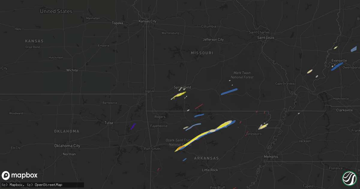
Hail Map on March 6, 2022
Get this storm
March 6 map
$229
one time, instant access
Download today. No call, no setup
Keep the $229
Bought the map and want the full workflow? Apply the entire $229 to a subscription within 7 days. None of it is wasted.
Every map, not just this one
This buys you this map. Subscription and you get every map we run, in the markets you choose from a few cities to whole states to nationwide. Plus real-time alerts the moment a storm fires.
Contact data
Name, contact info, occupancy, even credit band for addresses in the footprint. You go from where it hit to who to call.
Become the source they trust
Unlimited branding weather history reports on demand. You already have the documented answer ready for the property owner, and you are the one who showed up with it.
Property data and RoofTrace estimates
Pull up any address you have got, its value and the exact code rules for that jurisdiction, straight from One Click Code. Then RoofTrace estimates the squares, pitch, and roof value, priced the way you price.
States Impacted by Hail Map on March 6, 2022
Storm reports
Ohio
| Date | Description |
|---|---|
| 03/06/20223:55 AM CST | Tree down on fountain ave. Time estimated |
| 03/05/202210:00 PM CST | At 359 AM EST, severe thunderstorms were located along a line extending from near Holgate to 7 miles northeast of Celina, moving east at 80 mph. HAZARD...70 mph wind gusts. SOURCE...Radar indicated. IMPACT...Expect considerable tree damage. Damage is likely to mobile homes, roofs, and outbuildings. Locations impacted include... Lima, Delphos, Ottawa, Bluffton, Fort Shawnee, Spencerville, Columbus Grove, Leipsic, Elida, Deshler, Kalida, Continental, Pandora, Holgate, Glandorf, Ottoville, Spencerville In Allen County, Hamler, Middle Point and Cairo.This includes Interstate 75 between mile markers 119 and 141. |
| 03/05/20229:58 PM CST | At 358 AM EST, a severe thunderstorm was located near Winchester, or 15 miles west of Greenville, moving east at 55 mph. HAZARD...60 mph wind gusts. SOURCE...Radar indicated. IMPACT...Expect damage to roofs, siding, and trees. This severe thunderstorm will remain over mainly rural areas of eastern Randolph County. |
| 03/05/20229:37 PM CST | At 337 AM EST, severe thunderstorms were located along a line extending from near Muncie to 7 miles west of New Castle, moving east at 55 mph. HAZARD...60 mph wind gusts. SOURCE...Radar indicated. IMPACT...Expect damage to trees and power lines. Locations impacted include... Richmond, Centerville, Cambridge City, Arcanum, Lewisburg, Hagerstown, New Paris, New Madison, Fountain City, Dublin, Franklin, Wayne Lakes, Eldorado, Verona, West Manchester, Greens Fork, East Germantown, Pitsburg, Spring Grove and Bethel.This includes the following Interstates... I-70 in Indiana between mile markers 134 and 156. I-70 in Ohio between mile markers 0 and 14. |
| 03/05/20229:28 PM CST | At 327 AM EST, a severe thunderstorm was located near Muncie, moving east at 70 mph. HAZARD...60 mph wind gusts. SOURCE...Radar indicated. IMPACT...Expect damage to roofs, siding, and trees. This severe thunderstorm will be near... Selma around 335 AM EST. Albany and Parker City around 340 AM EST. Farmland around 345 AM EST.Other locations in the path of this severe thunderstorm includeWinchester, Ridgeville, Union City and Saratoga.This includes Interstate 69 between mile markers 222 and 251. |
| 03/05/20229:21 PM CST | At 321 AM EST, severe thunderstorms were located along a line extending from near Auburn to near Monroeville to near Matthews, moving east at 80 mph. HAZARD...70 mph wind gusts. SOURCE...Radar indicated. IMPACT...Expect considerable tree damage. Damage is likely to mobile homes, roofs, and outbuildings. Locations impacted include... Fort Wayne, Lima, Defiance, New Haven, Auburn, Van Wert, Bluffton, Decatur, Napoleon, Bryan, Wauseon, Delphos, Garrett, Portland, Ottawa, Archbold, Berne, Fort Shawnee, Hicksville and Ossian.This includes the following highways... Interstate 469 between mile markers 4 and 6, and between milemarkers 9 and 30. Interstate 69 in Indiana between mile markers 310 and 339. Interstate 75 between mile markers 119 and 132. |
Oklahoma
| Date | Description |
|---|---|
| 03/05/20226:21 PM CST | A local report indicates 1.00 inch wind near 1 ESE HULBERT |
Indiana
| Date | Description |
|---|---|
| 03/06/20226:26 AM CST | At 1226 AM CST, severe thunderstorms were located along a line extending from near Earl Park to near Boswell to 8 miles east of Hoopeston, moving northeast at 70 mph. HAZARD...60 mph wind gusts. SOURCE...Radar indicated. IMPACT...Expect damage to roofs, siding, and trees. Severe thunderstorms will be near... Fowler around 130 AM EST. Remington around 1240 AM CST. Oxford around 140 AM EST. Otterbein around 145 AM EST.Other locations impacted by these severe thunderstorms includeTempleton, Swanington and Wadena.Including the following interstate... Indiana I-65 between mile markers 200 and 203. |
| 03/06/20223:10 AM CST | Trees down at 5156 n county road 100 e. |
| 03/06/20223:09 AM CST | Elementary school roof damaged... Trees and power poles knocked down. Time estimated from radar. |
| 03/06/20223:07 AM CST | Trees down at 550 s old michigan road |
| 03/06/20222:35 AM CST | Late report. Damage to a metal storage barn. Trees down. Time estimated by radar. |
| 03/06/20222:20 AM CST | Reports of a large tree blocking a roadway on sr 64 just west of bretzville. |
| 03/06/20222:10 AM CST | Trees down williams rd and 50n... Williams rd and 200w. Time estimated |
| 03/06/20222:05 AM CST | Report of a tree in roadway at sr 56 and 500 w. |
| 03/06/20221:40 AM CST | Late report. Large tree down. Time estimated by radar. |
| 03/06/20221:15 AM CST | Heavy wooden swing set blown over and thrown through a fence into a field. |
| 03/06/20221:15 AM CST | Wind gust broke 1 inch tree limbs and blew off shingles. Time estimated from radar. |
| 03/06/20221:05 AM CST | Late report. Tree damage on ford ridge rd. Time estimated by radar. |
| 03/06/20221:00 AM CST | Late report. A van was moved and a trailer was moved several hundred yards. Time estimated by radar. |
| 03/05/202211:15 PM CST | Late report. Debris in the road at sr 58 and cr 450s. Also... Social media pictures showing destroyed travel trailer and a vehicle flipped over. Possible tornado. Will |
| 03/05/20229:25 PM CST | At 325 AM EST, severe thunderstorms were located along a line extending from 6 miles west of Decatur to near Muncie, moving east at 55 mph. HAZARD...60 mph wind gusts. SOURCE...Radar indicated. IMPACT...Expect damage to trees and power lines. Locations impacted include... Troy, Sidney, Piqua, Greenville, Celina, Wapakoneta, St. Marys, Coldwater, New Bremen, Minster, Versailles, Covington, St. Henry, Newport, Cridersville, Bradford, Union City, Anna, Fort Loramie and Jackson Center.This includes I-75 in Ohio between mile markers 76 and 117. |
| 03/05/20229:16 PM CST | At 316 AM EST, a severe thunderstorm was located near Lawrence, or 12 miles northeast of Indianapolis, moving east at 55 mph. HAZARD...60 mph wind gusts. SOURCE...Radar indicated. IMPACT...Expect damage to roofs, siding, and trees. This severe thunderstorm will be near... McCordsville around 320 AM EST. Fortville around 325 AM EST. Ingalls around 330 AM EST. Pendleton around 335 AM EST.Other locations in the path of this severe thunderstorm includeShirley, Markleville, Wilkinson and Kennard.This includes the following highways... Interstate 69 between mile markers 200 and 205, near mile marker207, and between mile markers 215 and 218. Interstate 70 between mile markers 114 and 118. |
| 03/05/20229:05 PM CST | At 304 AM EST, a severe thunderstorm was located 9 miles northeast of Noblesville, or 9 miles west of Anderson, moving east at 70 mph. HAZARD...60 mph wind gusts. SOURCE...Radar indicated. IMPACT...Expect damage to roofs, siding, and trees. This severe thunderstorm will be near... Edgewood, Frankton and River Forest around 310 AM EST. Anderson, Alexandria, Country Club Heights and Woodlawn Heights around 315 AM EST. Chesterfield and Daleville around 320 AM EST.Other locations in the path of this severe thunderstorm includeYorktown, Ball State University, Muncie, Parker City, Selma andPrairie Creek Reservoir.This includes Interstate 69 between mile markers 205 and 252. |
| 03/05/20228:53 PM CST | At 253 AM EST, severe thunderstorms were located along a line extending from near Sweetser to 6 miles northwest of Noblesville, moving east at 60 mph. HAZARD...60 mph wind gusts. SOURCE...Radar indicated. IMPACT...Expect damage to roofs, siding, and trees. Locations impacted include... Marion, Hartford City, Gas City, Upland, Fairmount, Dunkirk, Montpelier, Jonesboro, Redkey, Sweetser, Swayzee, Pennville, Matthews, Sims, Nottingham, Fowlerton, Shamrock Lakes, Mill Grove, Herbst and Keystone.This includes Interstate 69 in Indiana between mile markers 252 and267. |
| 03/05/20228:43 PM CST | At 243 AM EST, severe thunderstorms were located along a line extending from near Winona Lake to 6 miles northwest of Wabash to 6 miles northeast of Kokomo, moving east at 65 mph. HAZARD...60 mph wind gusts. SOURCE...Radar indicated. IMPACT...Expect damage to roofs, siding, and trees. Locations impacted include... Fort Wayne, Marion, Huntington, New Haven, Warsaw, Peru, Wabash, Bluffton, Columbia City, North Manchester, Winona Lake, Ossian, Tri-lakes, Huntertown, Avilla, Churubusco, South Whitley, Sweetser, Andrews and North Webster.This includes the following highways... Interstate 469 between mile markers 0 and 15, and between milemarkers 25 and 30. Interstate 69 in Indiana between mile markers 266 and 322. |
| 03/05/20228:42 PM CST | At 241 AM EST, a severe thunderstorm was located 11 miles northwest of Danville, or 17 miles southeast of Crawfordsville, moving northeast at 75 mph. HAZARD...70 mph wind gusts. SOURCE...Radar indicated. IMPACT...Expect considerable tree damage. Damage is likely to mobile homes, roofs, and outbuildings. This severe thunderstorm will be near... Jamestown around 245 AM EST. Pittsboro and Lizton around 250 AM EST. Brownsburg around 255 AM EST. Zionsville and Whitestown around 300 AM EST.Other locations in the path of this severe thunderstorm includeMeridian Hills, Williams Creek, Carmel, Westfield, Fishers,Noblesville, Cicero, Arcadia and Morse Reservoir.This includes the following highways... Interstate 65 between mile markers 123 and 152. Interstate 69 between mile markers 205 and 210. Interstate 74 between mile markers 44 and 68. |
| 03/05/20228:27 PM CST | At 226 AM EST, a severe thunderstorm was located 11 miles north of Frankfort, moving northeast at 75 mph. HAZARD...60 mph wind gusts. SOURCE...Radar indicated. IMPACT...Expect damage to roofs, siding, and trees. This severe thunderstorm will be near... Russiaville around 235 AM EST. Kokomo and Indian Heights around 240 AM EST.This includes Interstate 65 between mile markers 154 and 170. |
| 03/05/20228:14 PM CST | At 214 AM EST, severe thunderstorms were located along a line extending from near Royal Center to 8 miles northeast of Delphi to 6 miles east of Lafayette, moving east at 50 mph. HAZARD...60 mph wind gusts. SOURCE...Radar indicated. IMPACT...Expect damage to roofs, siding, and trees. Locations impacted include... Logansport, Peru, Grissom Afb, Akron, Walton, Bunker Hill, Royal Center, Mexico, Lincoln, Wells, Galveston, Miami, Erie, Denver, Fulton, Macy, Onward, Clymers, Bennetts Switch and Nyena Lake. |
| 03/05/20228:11 PM CST | At 210 AM EST, a severe thunderstorm was located 10 miles southwest of Crawfordsville, moving east at 80 mph. HAZARD...70 mph wind gusts. SOURCE...Radar indicated. IMPACT...Expect considerable tree damage. Damage is likely to mobile homes, roofs, and outbuildings. This severe thunderstorm will be near... Ladoga and New Ross around 220 AM EST. Jamestown and Advance around 225 AM EST. Thorntown around 230 AM EST.Other locations in the path of this severe thunderstorm includeLebanon and Ulen.This includes the following highways... Interstate 65 between mile markers 134 and 153. Interstate 70 between mile markers 1 and 5. Interstate 74 between mile markers 23 and 66. |
| 03/05/20227:41 PM CST | At 139 AM EST, a severe thunderstorm was located over Chrisman, or 13 miles north of Paris, moving east at 75 mph. HAZARD...70 mph wind gusts. SOURCE...Radar indicated. IMPACT...Expect considerable tree damage. Damage is likely to mobile homes, roofs, and outbuildings. This severe thunderstorm will be near... Newport, Cayuga, Montezuma and Lodi around 150 AM EST. Kingman, Bloomingdale and Turkey Run State Park around 155 AM EST.Other locations in the path of this severe thunderstorm includeMarshall, Wallace, Judson, Waveland, Russellville, Alamo, ShadesState Park, New Market and Crawfordsville.This includes Interstate 74 between mile markers 23 and 35. |
| 03/05/20227:31 PM CST | At 131 AM EST, severe thunderstorms were located along a line extending from near Perkins to near Boswell to 10 miles northwest of Covington, moving east at 60 mph. HAZARD...60 mph wind gusts. SOURCE...Radar indicated. IMPACT...Expect damage to roofs, siding, and trees. Locations impacted include... Monticello, Brookston, Wolcott, Royal Center, Reynolds, Chalmers, Burnettsville, Clymers, Badger Grove, Smithson, Golden Hill, Indiana Beach, Norway, Idaville, Sitka, Cedar Point, Bell Center and Lake Cicott.This includes Interstate 65 between mile markers 185 and 198. |
| 03/05/20227:23 PM CST | At 122 AM EST, a severe thunderstorm was located 10 miles east of Rossville, or 17 miles northeast of Danville, moving east at 75 mph. HAZARD...60 mph wind gusts. SOURCE...Radar indicated. IMPACT...Expect damage to roofs, siding, and trees. This severe thunderstorm will be near... Pine Village and Rainsville around 130 AM EST. Lafayette, West Lafayette and Purdue University around 140 AM EST.Other locations in the path of this severe thunderstorm includeBattle Ground.This includes the following highways... Interstate 65 between mile markers 161 and 183. Interstate 74 between mile markers 1 and 22. |
| 03/05/20227:04 PM CST | At 104 AM EST, severe thunderstorms were located along a line extending from 21 miles west of Stevensville to Porter, moving east at 65 mph. HAZARD...60 mph wind gusts. SOURCE...Radar indicated. IMPACT...Expect damage to roofs, siding, and trees. Locations impacted include... Niles, Benton Harbor, St. Joseph, Dowagiac, Buchanan, Fair Plain, Benton Heights, Bridgman, New Buffalo, Berrien Springs, Watervliet, Three Oaks, Coloma, Stevensville, Shorewood-Tower Hill, Paw Paw Lake, Shorewood-Tower Hills-Harbert, Lake Michigan Beach, Bertrand and Pokagon.This includes the following highways... Interstate 196 between mile markers 0 and 7. Interstate 94 in Michigan between mile markers 0 and 42. |
| 03/05/20227:00 PM CST | At 100 AM CST, a severe thunderstorm was located near Charleston, moving east at 55 mph. HAZARD...60 mph wind gusts and penny size hail. SOURCE...Radar indicated. IMPACT...Expect damage to roofs, siding, and trees. This severe thunderstorm will be near... Westfield around 110 AM CST. Martinsville around 115 AM CST. Clarksville around 120 AM CST.Other locations in the path of this severe thunderstorm includeMarshall, Oliver, Dennison and Vermilion.This includes Interstate 70 between mile markers 137 and 154. |
Arkansas
| Date | Description |
|---|---|
| 03/06/20225:24 PM CST | Trees fell on a home on walnut valley road and on a home on sara page road. There were no injuries reported. |
| 03/06/20225:23 PM CST | Tornado video posted on social media west of hector. Trees were down and damage reported at the martin township fire department. |
| 03/06/20225:21 PM CST | Trees down from a confirmed tornado near the rushing road area approximately 3 miles north of dover... Ar. |
| 03/06/20224:03 PM CST | Funnel or possible tornado located 13 miles southeast of bono ar... Northeast at 35 mph. |
| 03/06/20223:50 PM CST | Metal shed destroyed near the intersection of pitts road and long creek ln. |
| 03/06/20224:31 AM CST | At 1031 PM CST, severe thunderstorms were located along a line extending from 8 miles southwest of Culp to 7 miles west of Mountain View to Old Lexington, moving east at 60 mph. HAZARD...60 mph wind gusts. SOURCE...Radar indicated. IMPACT...Expect damage to roofs, siding, and trees. Locations impacted include... Mountain View... Melbourne... Calico Rock... Oxford... Mount Pleasant... Pineville... Franklin... Lone Star... Wideman... Gid... Herpel... Lunenburg... Culp... Blanchard Springs Campground... Thola... Brandenberg... Croker... Gorby... Stella... Old Lexington... |
| 03/06/20224:25 AM CST | At 1025 PM CST, a severe thunderstorm was located over Plainview in Yell County, or near Danville, moving northeast at 60 mph. HAZARD...60 mph wind gusts. SOURCE...Radar indicated. IMPACT...Expect damage to roofs, siding, and trees. Locations impacted include... Russellville... Danville... Dardanelle... Atkins... Pottsville... Ola... Adona... Carden Bottoms... Happy Bend... Petit Jean State Park... Plainview in Yell County... Petit Jean River WMA... Galla Creek WMA... Mosley... Belleville... Casa... Aplin... Corinth... Birta... Ada...This includes Interstate 40 between mile markers 86 and 99. |
| 03/06/20224:05 AM CST | At 1005 PM CST, severe thunderstorms were located along a line extending from near Kay to near Woolum to 6 miles north of Jerusalem, moving east at 55 mph. HAZARD...60 mph wind gusts and quarter size hail. SOURCE...Radar indicated. IMPACT...Hail damage to vehicles is expected. Expect wind damage to roofs, siding, and trees. Locations impacted include... Clinton... Fairfield Bay... Marshall... Hector... Shirley... Marsena... Witts Spring... Rocky Hill... Dabney... Bohannon... Sugar Loaf Recreation Area... Imo... Elberta... Watts... Thola... Kay... Fairfield Bay Marina... Claude... Elba... Woolum... |
| 03/06/20223:52 AM CST | At 952 PM CST, a severe thunderstorm was located 9 miles southwest of Gravelly, or 16 miles southeast of Waldron, moving east at 55 mph. HAZARD...60 mph wind gusts and quarter size hail. SOURCE...Radar indicated. IMPACT...Hail damage to vehicles is expected. Expect wind damage to roofs, siding, and trees. Locations impacted include... Danville... Cardiff... Gravelly... Fourche Valley... Muddy Creek WMA... Plainview in Yell County... Belleville... Corinth... Ranger... Wing... Olio... Kingston... Bluffton... Rover... Blue Ball... Union Hill... Chula... Macedonia in Yell County... Cedar Creek... Waltreak... |
| 03/06/20222:56 AM CST | At 855 PM CST, a severe thunderstorm was located over Beauchamp, or 10 miles southwest of Waldron, moving northeast at 60 mph. HAZARD...60 mph wind gusts and nickel size hail. SOURCE...Radar indicated. IMPACT...Expect damage to roofs, siding, and trees. Locations impacted include... Waldron... Beauchamp... Cardiff... Oliver... Morgan Springs... Bates... Cauthron... Winfield... Olio... Hon... Cedar Creek... Needmore... Harvey... Boles... Parks... Grayson... Y City... |
| 03/06/20222:55 AM CST | Five power poles were knocked down on highway 316 one mile north of highway 49. |
| 03/06/20222:55 AM CST | Corrects previous tstm wnd dmg report from 4 wsw lexa. Three power poles were knocked down on highway 316 one mile north of highway 49. One tree was also knocked down a |
| 03/06/20222:43 AM CST | At 843 PM CST, a severe thunderstorm was located 6 miles northeast of Fern, moving northeast at 55 mph. HAZARD...60 mph wind gusts and half dollar size hail. SOURCE...Radar indicated. IMPACT...Hail damage to vehicles is expected. Expect wind damage to roofs, siding, and trees. Locations in or near the path include... St. Paul... Cass... Saint Paul... Pettigrew... Kingston... Witter... Boston... Dutton... Bidville... Red Star... Weathers... Delaney... Brashears... Patrick... Combs... Turners Bend... |
| 03/06/20222:14 AM CST | At 814 PM CST, a severe thunderstorm was located 3 miles west of Figure Five, moving northeast at 45 mph. HAZARD...60 mph wind gusts and quarter size hail. SOURCE...Radar indicated. IMPACT...Hail damage to vehicles is expected. Expect wind damage to roofs, siding, and trees. Locations in or near the path include... Van Buren... Cedarville... Mountainburg... Alma... Chester... Rudy... Lake Fort Smith... Figure Five... Fern... Concord... Shibley... Piney... Uniontown... Locke... Dora... Furry...This includes the following highways, Interstate 40 in Arkansas between mile markers 0 and 14. Interstate 540 between mile markers 1 and 3. Interstate 49 between mile markers 22 and 38. |
| 03/06/20222:11 AM CST | Trees were blown down on highway 1 5 miles south of dewitt. |
| 03/06/202212:23 AM CST | At 623 PM CST, a severe thunderstorm was located 6 miles northeast of Peggs, moving northeast at 70 mph. Quarter size hail has been reported with this storm. HAZARD...60 mph wind gusts and quarter size hail. SOURCE...Trained weather spotters. IMPACT...Hail damage to vehicles is expected. Expect wind damage to roofs, siding, and trees. Locations in or near the path include... Tahlequah... Jay... Gravette... Decatur... Colcord... Kansas... Hulbert... Oaks... Maysville... Peggs... Rose... Hiwasse... Leach... Scraper... Twin Oaks... Lake Eucha State Park... Lost City... Cherokee City... Natural Falls State Park... |
| 03/05/20228:34 PM CST | A local report indicates 1.00 inch wind near 1 NNE MOUNTAINBURG |
| 03/05/20228:05 PM CST | Several power poles knocked down along with damage to poultry houses and two structures. |
| 03/05/20227:36 PM CST | Trained storm spotter report of 62 mph wind gust with trees and power lines down at the junction of highway 167 and bear valley road about 5 miles north of evening shad |
| 03/05/20227:32 PM CST | Trained storm chasers reported power flashes and tree debris across highway 167 approximately 3 miles north of evening shade... Ar. This was possibly a tornado. |
| 03/05/20227:32 PM CST | Trained storm chasers reported power flashes and tree debris across highway 167 approximately 3 miles north of evening shade... Ar. This was possibly a tornado. |
| 03/05/20227:24 PM CST | *** 5 inj *** a severe thunderstorm with a possible tornado damaged two houses with possibly 5 injured. This was on jackson schoolhouse rd. 3 ene of zion. |
| 03/05/20227:17 PM CST | Two barns on finley creek road sustained damage... And multiple mobile homes were blown off of their blocks on piney cove road. |
| 03/05/20226:48 PM CST | Power lines and trees were blown down on north ridgeview drive. |
| 03/05/20226:34 PM CST | Power lines and trees were blown down on ramsey cemetery road. |
| 03/05/20226:32 PM CST | Power lines and trees were blown down on jimmy creek road. |
Illinois
| Date | Description |
|---|---|
| 03/05/202211:03 PM CST | Multiple machine sheds and outbuildings destroyed near duncanville... East of hwy 1. |
| 03/05/20227:47 PM CST | At 146 AM EST, a severe thunderstorm was located 9 miles south of Otterbein, moving east at 75 mph. HAZARD...60 mph wind gusts. SOURCE...Radar indicated. IMPACT...Expect damage to roofs, siding, and trees. This severe thunderstorm will be near... Lafayette, West Lafayette, Shadeland and Purdue University around 155 AM EST. Dayton and Battle Ground around 205 AM EST. Delphi and Rossville around 210 AM EST.Other locations in the path of this severe thunderstorm includeFlora, Camden and Burlington.This includes the following highways... Interstate 65 between mile markers 154 and 184. Interstate 74 between mile markers 1 and 22. |
Missouri
| Date | Description |
|---|---|
| 03/06/20225:35 PM CST | Video relayed to the national weather service from emergency management of an apparent tornado over an open field east of neelyville. No known damage at this time. Time |
| 03/06/20226:57 AM CST | Media relayed photo of barn damage from the lenox mo area. Damage estimated between 655 pm and 700 pm. |
| 03/06/20224:57 AM CST | At 1057 PM CST, severe thunderstorms were located along a line extending from 10 miles east of Eminence to near Winona to near Birch Tree to 9 miles west of Alton to 9 miles west of Thayer, moving east at 50 mph. HAZARD...60 mph wind gusts and penny size hail. SOURCE...Radar indicated. IMPACT...Expect damage to roofs, siding, and trees. Locations impacted include... Grand Gulf State Park... Ozark National Scenic Riverways... Thayer... Winona... Alton... Birch Tree... Eminence... Koshkonong... Thomasville... Myrtle... Wilderness... Couch... Rover... West Eminence... Greer... |
| 03/06/20224:55 AM CST | At 1055 PM CST, severe thunderstorms were located along a line extending from 10 miles east of Eminence to 6 miles southeast of Birch Tree to 11 miles west of Thayer, moving east at 50 mph. HAZARD...60 mph wind gusts. SOURCE...Radar indicated. IMPACT...Expect damage to roofs, siding, and trees. Severe thunderstorms will be near... Fremont around 1115 PM CST.Other locations in the path of these severe thunderstorms include VanBuren and Handy. |
| 03/06/20224:05 AM CST | At 1005 PM CST, severe thunderstorms were located along a line extending from 9 miles northeast of Willow Springs to 6 miles west of Mountain View to 9 miles north of West Plains to near Bakersfield, moving northeast at 140 mph. HAZARD...60 mph wind gusts. SOURCE...Radar indicated. IMPACT...Expect damage to roofs, siding, and trees. Locations impacted include... West Plains... Current River State Park... Ozark National Scenic Riverways... Echo Bluff State Park... Mountain View... Willow Springs... Winona... Alton... Birch Tree... Eminence... Pomona... Summersville... South Fork... Koshkonong... Brandsville... Montier... Thomasville... Teresita... Midridge... Pottersville... |
| 03/06/20223:33 AM CST | At 933 PM CST, severe thunderstorms were located along a line extending from 11 miles west of Willow Springs to 17 miles northeast of Gainesville to near Price Place, moving east at 60 mph. HAZARD...60 mph wind gusts and penny size hail. SOURCE...Radar indicated. IMPACT...Expect damage to roofs, siding, and trees. Locations impacted include... West Plains... Norfork Lake... Mountain View... Willow Springs... Pomona... Summersville... Bakersfield... South Fork... Brandsville... Peace Valley... Lanton... Tecumseh... Arroll... Pottersville... Caulfield... Udall... Siloam Springs... White Church... Moody... Clear Springs... |
| 03/06/20223:04 AM CST | At 903 PM CST, severe thunderstorms were located along a line extending from 14 miles south of Ava to 11 miles northwest of Price Place to 8 miles northeast of Diamond City, moving east at 45 mph. HAZARD...60 mph wind gusts and penny size hail. SOURCE...Radar indicated. IMPACT...Expect damage to roofs, siding, and trees. Locations impacted include... Bull Shoals Lake... Norfork Lake... Gainesville... Bakersfield... Theodosia... Pontiac... Wasola... Sundown... Brixey... Willhoit... Tecumseh... Udall... Hardenville... Thornfield... Vanzant... Squires... Zanoni... Noble... Gentryville... Sycamore... |
| 03/06/20222:41 AM CST | At 841 PM CST, severe thunderstorms were located along a line extending from 8 miles southeast of Taneyville to 8 miles northwest of Diamond City, moving northeast at 55 mph. HAZARD...60 mph wind gusts and quarter size hail. SOURCE...Radar indicated. IMPACT...Hail damage to vehicles is expected. Expect wind damage to roofs, siding, and trees. Locations impacted include... Bull Shoals Lake... Protem... Rueter... |
| 03/06/20221:56 AM CST | A local report indicates 1.25 inch wind near ARBYRD |
| 03/06/20221:54 AM CST | A local report indicates 1.00 inch wind near CARDWELL |
| 03/05/202211:13 PM CST | At 512 PM CST, a severe thunderstorm was located near Corning, moving northeast at 35 mph. HAZARD...60 mph wind gusts and penny size hail. SOURCE...Radar indicated. IMPACT...Expect damage to roofs, siding, and trees. This severe thunderstorm will be near... Naylor around 520 PM CST. Neelyville around 525 PM CST. |
| 03/05/202210:15 PM CST | Report of knocked down tree along highway jj just north of summersville. |
| 03/05/20228:24 PM CST | Report from mping: half dollar |
| 03/05/20228:15 PM CST | A local report indicates 1.00 inch wind near 4 SSE BOAZ |
Kentucky
| Date | Description |
|---|---|
| 03/06/20224:05 AM CST | *** 1 fatal *** corrects previous tstm wnd dmg report from 3 s murray. 1 fatality. Semi-trailer blown over on us-641 south of midway near phillips drive. The semi-truck |
| 03/06/20224:05 AM CST | Semi-trailer blown over on us-641 south of murray. |
| 03/06/20222:45 AM CST | At 844 PM CST, a severe thunderstorm was located over Henderson, moving northeast at 55 mph. HAZARD...60 mph wind gusts and penny size hail. SOURCE...Radar indicated. IMPACT...Expect damage to roofs, siding, and trees. This severe thunderstorm will be near... Evansville around 855 PM CST. Newburgh and Chandler around 900 PM CST.Other locations in the path of this severe thunderstorm includeBoonville, Folsomville, Dale and Santa Claus.This includes the following highways... Interstate 69 in Kentucky between Mile Markers 147 and 148. Interstate 69 in Indiana between Mile Markers 1 and 12. Interstate 64 in Indiana between Mile Markers 46 and 60. Audubon Parkway between Mile Markers 1 and 3. |
| 03/05/202210:08 PM CST | At 408 PM EST, a severe thunderstorm was located near Shirley, or 12 miles southwest of Irvine, moving east at 50 mph. HAZARD...60 mph wind gusts and penny size hail. SOURCE...Radar indicated. IMPACT...Expect damage to roofs, siding, and trees. This severe thunderstorm will be near... Jinks around 415 PM EST. Wagersville around 420 PM EST. Leighton around 425 PM EST.Other locations in the path of this severe thunderstorm include OldLanding, Beattyville and Fincastle. |
| 03/05/20229:46 PM CST | At 346 PM EST, a severe thunderstorm was located 7 miles southeast of Lancaster, moving east at 50 mph. HAZARD...60 mph wind gusts. SOURCE...Radar indicated. IMPACT...Expect damage to roofs, siding, and trees. This severe thunderstorm will remain over mainly rural areas of southeastern Garrard and southern Madison Counties, including the following locations... Duluth, Paint Lick, Bighill, Manse, Panola, Kingston, Whites, Buggytown, Cartersville and Hyattsville. |
| 03/05/20228:43 PM CST | Small tree limbs down. |
| 03/05/20228:40 PM CST | Awos station kehr henderson ky. |
Michigan
| Date | Description |
|---|---|
| 03/06/20226:00 AM CST | Large tree knocked down. |
Cities Impacted by Hail Map on March 6, 2022
- Hector, AR
- Lamar, AR
- Scranton, AR
- Dover, AR
- Mountain View, AR
- Fifty Six, AR
- Timbo, AR
- Cardwell, MO
- Arbyrd, MO
- Paragould, AR
- Carrier Mills, IL
- Stonefort, IL
- Billings, MO
- Nixa, MO
- Clever, MO
- Marshall, AR
- Leslie, AR
- Jerusalem, AR
- Tilly, AR
- Pelsor, AR
- Patoka, IN
- Princeton, IN
- Owensville, IN
- Marionville, MO
- Aurora, MO
- Ozark, MO
- Crane, MO
- Pampa, TX
- Melbourne, AR
- Sage, AR
- Franklin, AR
- Jasper, AR
- Hasty, AR
- Parthenon, AR
- Harrison, AR
- Harrisburg, IL
- Cedarcreek, MO
- Kirbyville, MO
- Hardy, AR
- Ash Flat, AR
- Evening Shade, AR
- Horseshoe Bend, AR
- Vichy, MO
- Henderson, KY
- Waverly, KY
- Raywick, KY
- Campbellsville, KY
- Lebanon, KY
- Willisburg, KY
- Harrodsburg, KY
- Rector, AR
- Elizabethtown, IL
- Rosiclare, IL
- Springfield, MO
- Brookline, MO
- Republic, MO
- Vancleve, KY
- Senath, MO
- Subiaco, AR
- New Blaine, AR
- Dennard, AR
- Knoxville, AR
- London, AR
- Salem, MO
- Onia, AR
- Rogersville, MO
- Monette, AR
- Shamrock, TX
- Witts Springs, AR
- Herod, IL
- Eminence, MO
- Quail, TX
- Hedley, TX
- Union City, TN
- Sidney, AR
- Violet Hill, AR
- Columbus, IN
- Edinburgh, IN
- Stendal, IN
- Paoli, IN
- Dale, IN
- Dubois, IN
- French Lick, IN
- English, IN
- Jasper, IN
- Celestine, IN
- Holland, IN
- Saint Anthony, IN
- Huntingburg, IN
- Schnellville, IN
- Eckerty, IN
- Birdseye, IN
- Galena, MO
- Highlandville, MO
- Winona, MO
- Mountain View, MO
- Summersville, MO
- Birch Tree, MO
- Willow Springs, MO
- Evansville, IN
- Morganfield, KY
- Spottsville, KY
- Corydon, KY
- Paris, AR
- Peggs, OK
- Hulbert, OK
- Rose, OK
- Mount Pleasant, AR
- Guion, AR
- Williford, AR
- Poughkeepsie, AR
- Clinton, AR
- Fox, AR
- Pollard, AR
- Corning, AR
- Strawberry, AR
- Lynn, AR
- Imboden, AR
- Everton, AR
- Valley Springs, AR
- Yellville, AR
- Saint Joe, AR
- Vendor, AR
- Western Grove, AR
- Mountain Home, AR
- Lakeview, AR
- Midway, AR
- Bull Shoals, AR
- Peel, AR
- Dardanelle, AR
- Ola, AR
- Danville, AR
- Rison, AR
- Pine Bluff, AR
- Bearden, AR
- Yorktown, AR
- Grady, AR
- Fordyce, AR
- Hampton, AR
- Kingsland, AR
- Thornton, AR
- Star City, AR
- New Edinburg, AR
- Harrell, AR
- Warren, AR
- Banks, AR
- Wilmar, AR
- Mountainburg, AR
- Chester, AR