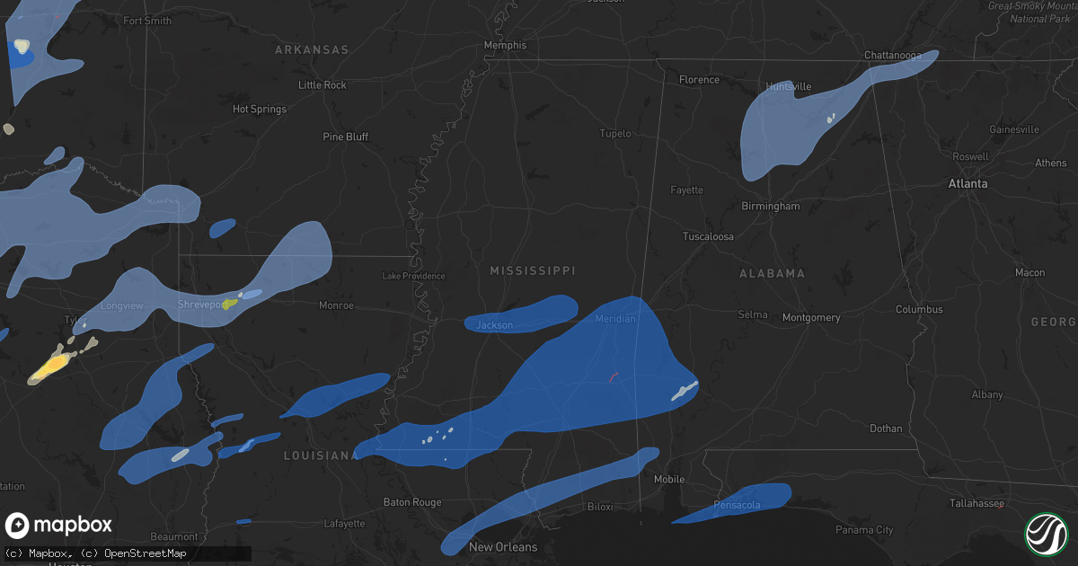
Hail Map in Mississippi on March 4, 2025
Get this storm
March 4 map
$229
one time, instant access
Download today. No call, no setup
Keep the $229
Bought the map and want the full workflow? Apply the entire $229 to a subscription within 7 days. None of it is wasted.
Every map, not just this one
This buys you this map. Subscription and you get every map we run, in the markets you choose from a few cities to whole states to nationwide. Plus real-time alerts the moment a storm fires.
Contact data
Name, contact info, occupancy, even credit band for addresses in the footprint. You go from where it hit to who to call.
Become the source they trust
Unlimited branding weather history reports on demand. You already have the documented answer ready for the property owner, and you are the one who showed up with it.
Property data and RoofTrace estimates
Pull up any address you have got, its value and the exact code rules for that jurisdiction, straight from One Click Code. Then RoofTrace estimates the squares, pitch, and roof value, priced the way you price.
Storm reports in Mississippi
Mississippi
| Date | Description |
|---|---|
| 03/04/20255:50 PM CST | A few trees down and some power lines in the central parts of the county. Rose ln and buffalo hill rd. |
| 03/04/20255:45 PM CST | Tree downed along cr 812. |
| 03/04/20255:38 PM CST | Tree downed on archie smith rd. |
| 03/04/20255:03 PM CST | Tree down on old hwy 24 west. |
| 03/04/20254:55 PM CST | A few trees down scattered about as the line of storms moved through. |
| 03/04/20254:54 PM CST | Tree down on w reservoir rd. |
| 03/04/20254:33 PM CST | A few trees down in the county. |
| 03/04/20254:22 PM CST | Tree down. |
| 03/04/20254:03 PM CST | Roof damage to a storm |
| 03/04/20253:52 PM CST | Couple trees down on roads in the s part of the county. |
| 03/04/20253:19 PM CST | Report from mping: 3-inch tree limbs broken. |
| 03/04/20253:16 PM CST | A couple trees down. |
| 03/04/20253:07 PM CST | 70mph wind gust measured with anemometer. Intersection of hwy 18 and hwy 80. |
| 03/04/20252:58 PM CST | A couple trees down. |
| 03/04/20252:37 PM CST | Tree down on hinds blvd blocking road. |
| 03/04/20252:04 PM CST | Tree down in town. |
| 03/04/20251:43 PM CST | A few trees down in town... One on a home. |
| 03/03/20257:55 PM CST | An ef1 tornado began near the intersection of marshall smith road and cooks corner road where a farm building was completely destroyed on the west side of the road. On |
| 03/03/20257:05 PM CST | Thunderstorm winds downed power lines across northern portions of hancock county near necaise. |
| 03/03/20256:47 PM CST | Trees downed around the 100 block of old hwy 49 s. |
| 03/03/20256:30 PM CST | Significant structural damage reported near whistler. Likely tornado based on radar tds. |
| 03/03/20256:30 PM CST | Significant structural damage reported near whistler. Likely tornado based on radar tds. |
| 03/03/20256:30 PM CST | Scattered trees down in the county. |
| 03/03/20256:24 PM CST | *** 4 inj *** the tornado began in the forested area near earl pitts rd before rapidly strengthening as it crossed highway 84. A single vehicle was rolled in a parking |
| 03/03/20256:20 PM CST | Large tree downed in front of house on poplar springs drive... Between 23rd and 24th street. |
| 03/03/20256:18 PM CST | Corrects previous tstm wnd gst report from hattiesburg. 58 mph wind gust measured at hbg airport. |
| 03/03/20256:18 PM CST | Corrects previous tstm wnd gst report from hattiesburg. 58 mph wind gust measured at hbg airport. |
| 03/03/20256:18 PM CST | 58 mph wind gust measured at hbg airport. |
| 03/03/20256:15 PM CST | Tree and powerlines downed on cal bonner dr. |
| 03/03/20256:13 PM CST | Tree downed at the intersection of timber lakes dr and thagard dr. |
All States Impacted by Hail Map on March 4, 2025
Cities Impacted by Hail Map on March 4, 2025
- Weleetka, OK
- Lamar, OK
- Wetumka, OK
- Dustin, OK
- Holdenville, OK
- Mcalester, OK
- Stuart, OK
- Kiowa, OK
- Wardville, OK
- Eufaula, OK
- Hanna, OK
- Indianola, OK
- Krebs, OK
- Savanna, OK
- Blanco, OK
- Caney, OK
- Atoka, OK
- Columbia, MO
- Auxvasse, MO
- Clearwater, NE
- Crowder, OK
- Canadian, OK
- Henryetta, OK
- Checotah, OK
- Council Hill, OK
- Boynton, OK
- Oktaha, OK
- Coalgate, OK
- Calvin, OK
- Pittsburg, OK
- Seagoville, TX
- Leonard, TX
- Ravenna, TX
- Forney, TX
- Trenton, TX
- Whitewright, TX
- Bonham, TX
- Celeste, TX
- Savoy, TX
- Randolph, TX
- Royse City, TX
- Blue Ridge, TX
- Nevada, TX
- Ector, TX
- Crandall, TX
- Rockwall, TX
- Farmersville, TX
- Lavon, TX
- Caddo Mills, TX
- Terrell, TX
- Greenville, TX
- Bailey, TX
- Wolfe City, TX
- Windom, TX
- Cooper, TX
- Brashear, TX
- Campbell, TX
- Klondike, TX
- Ladonia, TX
- Dodd City, TX
- Cumby, TX
- Sulphur Springs, TX
- Pecan Gap, TX
- Commerce, TX
- Honey Grove, TX
- Dike, TX
- Enloe, TX
- Roxton, TX
- Paris, TX
- Ben Franklin, TX
- Telephone, TX
- Petty, TX
- Sumner, TX
- Brookston, TX
- Lake Creek, TX
- Lone Oak, TX
- Point, TX
- Wills Point, TX
- Quinlan, TX
- Emory, TX
- Yantis, TX
- Mineola, TX
- Alba, TX
- Quitman, TX
- Como, TX
- Winnsboro, TX
- Pickton, TX
- Blossom, TX
- Pattonville, TX
- Sulphur Bluff, TX
- Saltillo, TX
- Deport, TX
- Muskogee, OK
- Haskell, OK
- Braggs, OK
- Warner, OK
- Hugo, OK
- Fort Gibson, OK
- Wagoner, OK
- Porter, OK
- Taft, OK
- Oakwood, TX
- Palestine, TX
- Tennessee Colony, TX
- Haileyville, OK
- Hartshorne, OK
- Wilburton, OK
- Red Oak, OK
- Overbrook, OK
- Roff, OK
- Tupelo, OK
- Centrahoma, OK
- Fittstown, OK
- Stonewall, OK
- Ada, OK
- Mannsville, OK
- Davis, OK
- Marietta, OK
- Wapanucka, OK
- Konawa, OK
- Sulphur, OK
- Lone Grove, OK
- Dougherty, OK
- Allen, OK
- Tishomingo, OK
- Springer, OK
- Atwood, OK
- Sasakwa, OK
- Ardmore, OK
- Fitzhugh, OK
- Milburn, OK
- Mill Creek, OK
- Hinton, OK
- Butler, OK
- Sharon, OK
- Hennessey, OK
- Hitchcock, OK
- Dill City, OK
- Thomas, OK
- Arapaho, OK
- Chester, OK
- Anadarko, OK
- Foss, OK
- Eldorado, OK
- Rocky, OK
- Colony, OK
- Greenfield, OK
- Hydro, OK
- Vici, OK
- Mooreland, OK
- Clinton, OK
- Cordell, OK
- Hollis, OK
- Custer City, OK
- Childress, TX
- Canute, OK
- Okarche, OK
- Binger, OK
- Olustee, OK
- Carter, OK
- Drummond, OK
- Camargo, OK
- Quanah, TX
- Calumet, OK
- Canton, OK
- Sayre, OK
- Gracemont, OK
- Hobart, OK
- Watonga, OK
- Geary, OK
- Ames, OK
- Oakwood, OK
- Fairview, OK
- Kingfisher, OK
- Gould, OK
- Lookeba, OK
- Mountain Park, OK
- Carnegie, OK
- Duke, OK
- Bison, OK
- Mangum, OK
- Blair, OK
- Roosevelt, OK
- Lawton, OK
- Omega, OK
- Granite, OK
- Leedey, OK
- Loyal, OK
- Taloga, OK
- Mountain View, OK
- Willow, OK
- Sentinel, OK
- Putnam, OK
- Southard, OK
- Hammon, OK
- Elk City, OK
- Lone Wolf, OK
- Mutual, OK
- Headrick, OK
- Bessie, OK
- Fort Cobb, OK
- Waukomis, OK
- Corn, OK
- Weatherford, OK
- Minco, OK
- Okeene, OK
- Dover, OK
- Longdale, OK
- Seiling, OK
- Gotebo, OK
- El Reno, OK
- Altus, OK
- Fay, OK
- Kemp, TX
- Frankston, TX
- Tyler, TX
- Bullard, TX
- Flint, TX
- Jacksonville, TX
- Hulbert, OK
- Whitehouse, TX
- Talco, TX
- Winfield, TX
- Detroit, TX
- Leesburg, TX
- Mount Pleasant, TX
- Pittsburg, TX
- Scroggins, TX
- Mount Vernon, TX
- Bogata, TX
- Clarksville, TX
- Overton, TX
- Winona, TX
- Kilgore, TX
- Arp, TX
- Longview, TX
- White Oak, TX
- Gladewater, TX
- Hallsville, TX
- Harleton, TX
- Gilmer, TX
- Diana, TX
- Ore City, TX
- Troup, TX
- Lone Star, TX
- Avinger, TX
- Jefferson, TX
- Henderson, TX
- Tatum, TX
- Marshall, TX
- Karnack, TX
- Beckville, TX
- Waskom, TX
- Shreveport, LA
- Mooringsport, LA
- Diboll, TX
- Lufkin, TX
- Apple Springs, TX
- Corrigan, TX
- Groveton, TX
- Huntington, TX
- Greenwood, LA
- Bethany, LA
- Keithville, LA
- Blanchard, LA
- De Berry, TX
- Bossier City, LA
- Haughton, LA
- Barksdale Afb, LA
- Stonewall, LA
- Frierson, LA
- Etoile, TX
- Nacogdoches, TX
- Chireno, TX
- Timpson, TX
- Center, TX
- Tenaha, TX
- San Augustine, TX
- Zavalla, TX
- Livingston, TX
- Chester, TX
- Moscow, TX
- Woodville, TX
- Elm Grove, LA
- Princeton, LA
- Minden, LA
- Joaquin, TX
- Colmesneil, TX
- Shelbyville, TX
- Logansport, LA
- Broaddus, TX
- Doyline, LA
- Warren, TX
- Ringgold, LA
- Bronson, TX
- Grand Cane, LA
- Mansfield, LA
- Sibley, LA
- Heflin, LA
- Dubberly, LA
- Gibsland, LA
- Athens, LA
- Homer, LA
- Jasper, TX
- Arcadia, LA
- Princeton, TX
- Mesquite, TX
- Newton, TX
- Wiergate, TX
- Dubach, LA
- Bernice, LA
- Lillie, LA
- Spearsville, LA
- Farmerville, LA
- Marion, LA
- Florien, LA
- Anacoco, LA
- Hornbeck, LA
- Deridder, LA
- Evans, LA
- Leesville, LA
- Fort Polk, LA
- Pitkin, LA
- Boyce, LA
- Colfax, LA
- Dry Prong, LA
- Sulphur, LA
- Lake Charles, LA
- Westlake, LA
- Kaufman, TX
- Simmesport, LA
- Moreauville, LA
- Plaucheville, LA
- Lettsworth, LA
- Woodville, MS
- Monterey, LA
- Batchelor, LA
- Angola, LA
- Saint Francisville, LA
- Gloster, MS
- Centreville, MS
- Waco, TX
- Woodway, TX
- McGregor, TX
- Oglesby, TX
- Crawford, TX
- Gatesville, TX
- Hewitt, TX
- Lorena, TX
- Moody, TX
- Chilton, TX
- Marlin, TX
- Riesel, TX
- Groesbeck, TX
- Mart, TX
- Bruceville, TX
- Eddy, TX
- Troy, TX
- Crosby, MS
- Norwood, LA
- Purdon, TX
- Dawson, TX
- Corsicana, TX
- Powell, TX
- Kerens, TX
- Liberty, MS
- Trinidad, TX
- Mabank, TX
- Jackson, LA
- Wilson, LA
- Clinton, LA
- Hemphill, TX
- Magnolia, MS
- Smithdale, MS
- Mccomb, MS
- Summit, MS
- Lisbon, LA
- Haynesville, LA
- Junction City, AR
- Summerfield, LA
- El Dorado, AR
- Hampton, AR
- Calion, AR
- Strong, AR
- Jersey, AR
- Huttig, AR
- Edwards, MS
- Bolton, MS
- Raymond, MS
- Jackson, MS
- Byram, MS
- Richland, MS
- Flowood, MS
- Clinton, MS
- Pearl, MS
- Tougaloo, MS
- Brandon, MS
- Ridgeland, MS
- Ethel, LA
- Greensburg, LA
- Kentwood, LA
- Osyka, MS
- Bogue Chitto, MS
- Mount Hermon, LA
- Lena, LA
- Pelahatchie, MS
- Morton, MS
- Lena, MS
- Pineville, LA
- Forest, MS
- Pulaski, MS
- Conehatta, MS
- Walnut Grove, MS
- Bentley, LA
- Pollock, LA
- Trout, LA
- Jena, LA
- Ball, LA
- Alexandria, LA
- Deville, LA
- Jonesville, LA
- Sicily Island, LA
- Harrisonburg, LA
- Lake, MS
- Hineston, LA
- Tylertown, MS
- Jayess, MS
- Ruth, MS
- Sieper, LA
- Ferriday, LA
- Clayton, LA
- Newton, MS
- Decatur, MS
- Lawrence, MS
- Union, MS
- Sebastopol, MS
- Philadelphia, MS
- Franklinton, LA
- Monticello, MS
- Kokomo, MS
- Foxworth, MS
- Brookhaven, MS
- Oak Vale, MS
- Silver Creek, MS
- Fluker, LA
- Amite, LA
- Columbia, MS
- Prentiss, MS
- Magee, MS
- Collins, MS
- Mount Olive, MS
- Carson, MS
- Newhebron, MS
- Mendenhall, MS
- Raleigh, MS
- Pinola, MS
- Mize, MS
- Bassfield, MS
- Seminary, MS
- Sumrall, MS
- Lumberton, MS
- Taylorsville, MS
- Soso, MS
- Purvis, MS
- Petal, MS
- Hattiesburg, MS
- Moselle, MS
- Ellisville, MS
- Bay Springs, MS
- Little Rock, MS
- Enterprise, MS
- Heidelberg, MS
- Laurel, MS
- Collinsville, MS
- Chunky, MS
- Stringer, MS
- Paulding, MS
- Meridian, MS
- Louin, MS
- Vossburg, MS
- Hickory, MS
- Rose Hill, MS
- Waynesboro, MS
- Pachuta, MS
- Ovett, MS
- Shubuta, MS
- Daleville, MS
- Quitman, MS
- Richton, MS
- Toomsuba, MS
- Bailey, MS
- Marion, MS
- Lauderdale, MS
- Stonewall, MS
- Thibodaux, LA
- Vacherie, LA
- Gramercy, LA
- Paulina, LA
- Convent, LA
- Saint James, LA
- Garyville, LA
- Lutcher, LA
- Reserve, LA
- La Place, LA
- Mount Airy, LA
- Edgard, LA
- Hahnville, LA
- Covington, LA
- Ponchatoula, LA
- Madisonville, LA
- Mandeville, LA
- Lacombe, LA
- Poplarville, MS
- Kiln, MS
- Gulfport, MS
- Lucedale, MS
- Pearl River, LA
- Vancleave, MS
- Picayune, MS
- Saucier, MS
- Stennis Space Center, MS
- Carriere, MS
- Pass Christian, MS
- Slidell, LA
- McHenry, MS
- Perkinston, MS
- Abita Springs, LA
- Bay Saint Louis, MS
- Biloxi, MS
- Bush, LA
- Wilmer, AL
- Citronelle, AL
- New Augusta, MS
- Toxey, AL
- Butler, AL
- Melvin, AL
- Silas, AL
- Cuba, AL
- Lisman, AL
- Porterville, MS
- York, AL
- Needham, AL
- Gilbertown, AL
- Jachin, AL
- Ward, AL
- State Line, MS
- Leakesville, MS
- Buckatunna, MS
- Deer Park, AL
- Beaumont, MS
- Coffeeville, AL
- Leroy, AL
- Jackson, AL
- Fruitdale, AL
- Wagarville, AL
- Chatom, AL
- Saint Stephens, AL
- Campbell, AL
- Thomasville, AL
- Frankville, AL
- Tibbie, AL
- Millry, AL
- Chunchula, AL
- Sweet Water, AL
- Whatley, AL
- Grove Hill, AL
- Dickinson, AL
- Vinegar Bend, AL
- Neely, MS
- Arley, AL
- Vinemont, AL
- Addison, AL
- Crane Hill, AL
- Logan, AL
- Cullman, AL
- Cordova, AL
- Bremen, AL
- Jasper, AL
- Empire, AL
- Hanceville, AL
- Dora, AL
- Hayden, AL
- Sumiton, AL
- Warrior, AL
- Oneonta, AL
- Cleveland, AL
- Blountsville, AL
- Danville, AL
- Tanner, AL
- Joppa, AL
- Falkville, AL
- Valhermoso Springs, AL
- Somerville, AL
- Holly Pond, AL
- Laceys Spring, AL
- Huntsville, AL
- Eva, AL
- Madison, AL
- Baileyton, AL
- Decatur, AL
- Hartselle, AL
- Arab, AL
- Union Grove, AL
- Owens Cross Roads, AL
- Grant, AL
- Altoona, AL
- New Hope, AL
- Albertville, AL
- Horton, AL
- Boaz, AL
- Guntersville, AL
- Brownsboro, AL
- Groveoak, AL
- Crossville, AL
- Geraldine, AL
- Monticello, FL
- Fort Walton Beach, FL
- Navarre, FL
- Gulf Breeze, FL
- Mary Esther, FL
- Pensacola, FL
- Lillian, AL
- Orange Beach, AL
- Seminole, AL
- Elberta, AL
- Eglin Afb, FL
- Milton, FL
- Bagdad, FL
- Hurlburt Field, FL
- Shalimar, FL
- Bon Secour, AL
- Foley, AL
- Gulf Shores, AL
- Burkeville, TX
- Arthur City, TX
- Powderly, TX
- Grant, OK
- Fort Towson, OK
- Sawyer, OK
- Woodville, AL
- Paint Rock, AL
- Gurley, AL
- Langston, AL
- Scottsboro, AL
- De Kalb, TX
- Cookville, TX
- Avery, TX
- Annona, TX
- Naples, TX
- Simms, TX
- Omaha, TX
- New Boston, TX
- Foreman, AR
- Texarkana, TX
- Hooks, TX
- Maud, TX
- Fyffe, AL
- Section, AL
- Ashdown, AR
- Fouke, AR
- Nash, TX
- Texarkana, AR
- Dutton, AL
- Hollywood, AL
- Sylvania, AL
- Henagar, AL
- Dawson, AL
- Rainsville, AL
- Pisgah, AL
- Fulton, AR
- Ogden, AR
- Flat Rock, AL
- Fort Payne, AL
- Stevenson, AL
- Valley Head, AL
- Ider, AL
- Bryant, AL
- Higdon, AL
- Trenton, GA
- Rising Fawn, GA
- Lewisville, AR
- Taylor, AR
- Buckner, AR
- Stamps, AR
- Waldo, AR
- Chickamauga, GA
- Flintstone, GA
- Rossville, GA
- Wildwood, GA
- Lookout Mountain, GA
- La Fayette, GA
- Rock Spring, GA
- Ooltewah, TN
- Chattanooga, TN
- Fort Oglethorpe, GA
- Cleveland, TN
- McDonald, TN
- Ringgold, GA
- Apison, TN
- Cohutta, GA
- Tunnel Hill, GA
- Dalton, GA
- Old Fort, TN
- Rusk, TX
- Okmulgee, OK
- Morris, OK


