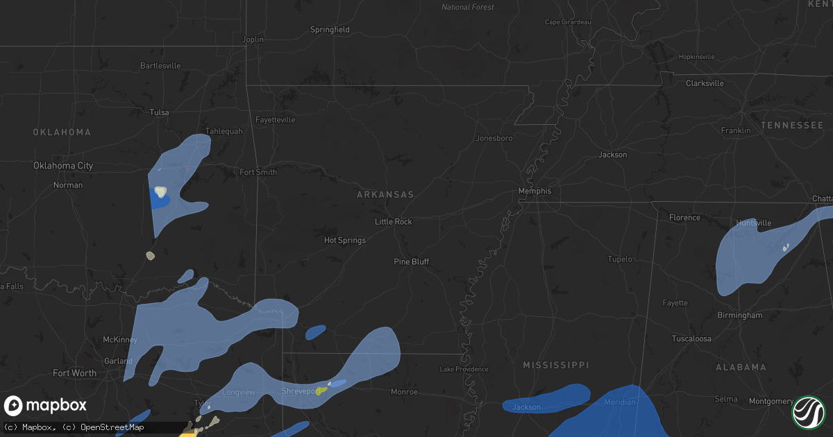
Hail Map in Arkansas on March 4, 2025
Get this storm
March 4 map
$229
one time, instant access
Download today. No call, no setup
Keep the $229
Bought the map and want the full workflow? Apply the entire $229 to a subscription within 7 days. None of it is wasted.
Every map, not just this one
This buys you this map. Subscription and you get every map we run, in the markets you choose from a few cities to whole states to nationwide. Plus real-time alerts the moment a storm fires.
Contact data
Name, contact info, occupancy, even credit band for addresses in the footprint. You go from where it hit to who to call.
Become the source they trust
Unlimited branding weather history reports on demand. You already have the documented answer ready for the property owner, and you are the one who showed up with it.
Property data and RoofTrace estimates
Pull up any address you have got, its value and the exact code rules for that jurisdiction, straight from One Click Code. Then RoofTrace estimates the squares, pitch, and roof value, priced the way you price.
Storm reports in Arkansas
Arkansas
| Date | Description |
|---|---|
| 03/04/20254:46 PM CST | Large tree limb reported in the road - near hwy 10 and washburn mountain loop area; time estimated by radar. |
| 03/04/202512:12 PM CST | Report of a measured wind gust of 61 mph along meadows rd in texarkana... Ar. |
| 03/04/202510:35 AM CST | Report of a large tree uprooted on a house at the intersection of sixth st and calion rd. |
| 03/04/20259:14 AM CST | Reports of fallen tree limbs and damage to several chicken houses at the intersection of cr 19 and cr 21. |
| 03/04/20259:10 AM CST | Hempstead county sheriff office received a report of trees down on hempstead 185 near hwy 278 w just outside of the town of old washington. |
| 03/04/20258:55 AM CST | Howard county sheriff office received report of a tree limb down on a home on w sunset st in nashville. |
| 03/04/20258:41 AM CST | Reports of multiple trees down in genoa. |
| 03/04/20258:30 AM CST | 911 dispatch center in sevier county received reports of multiple trees down on frog level road... Southeast of horatio. |
| 03/04/20258:20 AM CST | Little river sherriff office received reports of several trees down; near the intersection of ar 41 s and ar 32 w and along ar-32 w near the town of wallace... Ar. |
| 03/04/20258:20 AM CST | Little river sheriff office received report of a blown over tractor trailer near the intersection of ar 41 s and little river 4. |
| 03/04/20257:53 AM CST | Power poles down... Barn roof torn off. |
All States Impacted by Hail Map on March 4, 2025
Cities Impacted by Hail Map on March 4, 2025
- Weleetka, OK
- Lamar, OK
- Wetumka, OK
- Dustin, OK
- Holdenville, OK
- Mcalester, OK
- Stuart, OK
- Kiowa, OK
- Wardville, OK
- Eufaula, OK
- Hanna, OK
- Indianola, OK
- Krebs, OK
- Savanna, OK
- Blanco, OK
- Caney, OK
- Atoka, OK
- Columbia, MO
- Auxvasse, MO
- Clearwater, NE
- Crowder, OK
- Canadian, OK
- Henryetta, OK
- Checotah, OK
- Council Hill, OK
- Boynton, OK
- Oktaha, OK
- Coalgate, OK
- Calvin, OK
- Pittsburg, OK
- Seagoville, TX
- Leonard, TX
- Ravenna, TX
- Forney, TX
- Trenton, TX
- Whitewright, TX
- Bonham, TX
- Celeste, TX
- Savoy, TX
- Randolph, TX
- Royse City, TX
- Blue Ridge, TX
- Nevada, TX
- Ector, TX
- Crandall, TX
- Rockwall, TX
- Farmersville, TX
- Lavon, TX
- Caddo Mills, TX
- Terrell, TX
- Greenville, TX
- Bailey, TX
- Wolfe City, TX
- Windom, TX
- Cooper, TX
- Brashear, TX
- Campbell, TX
- Klondike, TX
- Ladonia, TX
- Dodd City, TX
- Cumby, TX
- Sulphur Springs, TX
- Pecan Gap, TX
- Commerce, TX
- Honey Grove, TX
- Dike, TX
- Enloe, TX
- Roxton, TX
- Paris, TX
- Ben Franklin, TX
- Telephone, TX
- Petty, TX
- Sumner, TX
- Brookston, TX
- Lake Creek, TX
- Lone Oak, TX
- Point, TX
- Wills Point, TX
- Quinlan, TX
- Emory, TX
- Yantis, TX
- Mineola, TX
- Alba, TX
- Quitman, TX
- Como, TX
- Winnsboro, TX
- Pickton, TX
- Blossom, TX
- Pattonville, TX
- Sulphur Bluff, TX
- Saltillo, TX
- Deport, TX
- Muskogee, OK
- Haskell, OK
- Braggs, OK
- Warner, OK
- Hugo, OK
- Fort Gibson, OK
- Wagoner, OK
- Porter, OK
- Taft, OK
- Oakwood, TX
- Palestine, TX
- Tennessee Colony, TX
- Haileyville, OK
- Hartshorne, OK
- Wilburton, OK
- Red Oak, OK
- Overbrook, OK
- Roff, OK
- Tupelo, OK
- Centrahoma, OK
- Fittstown, OK
- Stonewall, OK
- Ada, OK
- Mannsville, OK
- Davis, OK
- Marietta, OK
- Wapanucka, OK
- Konawa, OK
- Sulphur, OK
- Lone Grove, OK
- Dougherty, OK
- Allen, OK
- Tishomingo, OK
- Springer, OK
- Atwood, OK
- Sasakwa, OK
- Ardmore, OK
- Fitzhugh, OK
- Milburn, OK
- Mill Creek, OK
- Hinton, OK
- Butler, OK
- Sharon, OK
- Hennessey, OK
- Hitchcock, OK
- Dill City, OK
- Thomas, OK
- Arapaho, OK
- Chester, OK
- Anadarko, OK
- Foss, OK
- Eldorado, OK
- Rocky, OK
- Colony, OK
- Greenfield, OK
- Hydro, OK
- Vici, OK
- Mooreland, OK
- Clinton, OK
- Cordell, OK
- Hollis, OK
- Custer City, OK
- Childress, TX
- Canute, OK
- Okarche, OK
- Binger, OK
- Olustee, OK
- Carter, OK
- Drummond, OK
- Camargo, OK
- Quanah, TX
- Calumet, OK
- Canton, OK
- Sayre, OK
- Gracemont, OK
- Hobart, OK
- Watonga, OK
- Geary, OK
- Ames, OK
- Oakwood, OK
- Fairview, OK
- Kingfisher, OK
- Gould, OK
- Lookeba, OK
- Mountain Park, OK
- Carnegie, OK
- Duke, OK
- Bison, OK
- Mangum, OK
- Blair, OK
- Roosevelt, OK
- Lawton, OK
- Omega, OK
- Granite, OK
- Leedey, OK
- Loyal, OK
- Taloga, OK
- Mountain View, OK
- Willow, OK
- Sentinel, OK
- Putnam, OK
- Southard, OK
- Hammon, OK
- Elk City, OK
- Lone Wolf, OK
- Mutual, OK
- Headrick, OK
- Bessie, OK
- Fort Cobb, OK
- Waukomis, OK
- Corn, OK
- Weatherford, OK
- Minco, OK
- Okeene, OK
- Dover, OK
- Longdale, OK
- Seiling, OK
- Gotebo, OK
- El Reno, OK
- Altus, OK
- Fay, OK
- Kemp, TX
- Frankston, TX
- Tyler, TX
- Bullard, TX
- Flint, TX
- Jacksonville, TX
- Hulbert, OK
- Whitehouse, TX
- Talco, TX
- Winfield, TX
- Detroit, TX
- Leesburg, TX
- Mount Pleasant, TX
- Pittsburg, TX
- Scroggins, TX
- Mount Vernon, TX
- Bogata, TX
- Clarksville, TX
- Overton, TX
- Winona, TX
- Kilgore, TX
- Arp, TX
- Longview, TX
- White Oak, TX
- Gladewater, TX
- Hallsville, TX
- Harleton, TX
- Gilmer, TX
- Diana, TX
- Ore City, TX
- Troup, TX
- Lone Star, TX
- Avinger, TX
- Jefferson, TX
- Henderson, TX
- Tatum, TX
- Marshall, TX
- Karnack, TX
- Beckville, TX
- Waskom, TX
- Shreveport, LA
- Mooringsport, LA
- Diboll, TX
- Lufkin, TX
- Apple Springs, TX
- Corrigan, TX
- Groveton, TX
- Huntington, TX
- Greenwood, LA
- Bethany, LA
- Keithville, LA
- Blanchard, LA
- De Berry, TX
- Bossier City, LA
- Haughton, LA
- Barksdale Afb, LA
- Stonewall, LA
- Frierson, LA
- Etoile, TX
- Nacogdoches, TX
- Chireno, TX
- Timpson, TX
- Center, TX
- Tenaha, TX
- San Augustine, TX
- Zavalla, TX
- Livingston, TX
- Chester, TX
- Moscow, TX
- Woodville, TX
- Elm Grove, LA
- Princeton, LA
- Minden, LA
- Joaquin, TX
- Colmesneil, TX
- Shelbyville, TX
- Logansport, LA
- Broaddus, TX
- Doyline, LA
- Warren, TX
- Ringgold, LA
- Bronson, TX
- Grand Cane, LA
- Mansfield, LA
- Sibley, LA
- Heflin, LA
- Dubberly, LA
- Gibsland, LA
- Athens, LA
- Homer, LA
- Jasper, TX
- Arcadia, LA
- Princeton, TX
- Mesquite, TX
- Newton, TX
- Wiergate, TX
- Dubach, LA
- Bernice, LA
- Lillie, LA
- Spearsville, LA
- Farmerville, LA
- Marion, LA
- Florien, LA
- Anacoco, LA
- Hornbeck, LA
- Deridder, LA
- Evans, LA
- Leesville, LA
- Fort Polk, LA
- Pitkin, LA
- Boyce, LA
- Colfax, LA
- Dry Prong, LA
- Sulphur, LA
- Lake Charles, LA
- Westlake, LA
- Kaufman, TX
- Simmesport, LA
- Moreauville, LA
- Plaucheville, LA
- Lettsworth, LA
- Woodville, MS
- Monterey, LA
- Batchelor, LA
- Angola, LA
- Saint Francisville, LA
- Gloster, MS
- Centreville, MS
- Waco, TX
- Woodway, TX
- McGregor, TX
- Oglesby, TX
- Crawford, TX
- Gatesville, TX
- Hewitt, TX
- Lorena, TX
- Moody, TX
- Chilton, TX
- Marlin, TX
- Riesel, TX
- Groesbeck, TX
- Mart, TX
- Bruceville, TX
- Eddy, TX
- Troy, TX
- Crosby, MS
- Norwood, LA
- Purdon, TX
- Dawson, TX
- Corsicana, TX
- Powell, TX
- Kerens, TX
- Liberty, MS
- Trinidad, TX
- Mabank, TX
- Jackson, LA
- Wilson, LA
- Clinton, LA
- Hemphill, TX
- Magnolia, MS
- Smithdale, MS
- Mccomb, MS
- Summit, MS
- Lisbon, LA
- Haynesville, LA
- Junction City, AR
- Summerfield, LA
- El Dorado, AR
- Hampton, AR
- Calion, AR
- Strong, AR
- Jersey, AR
- Huttig, AR
- Edwards, MS
- Bolton, MS
- Raymond, MS
- Jackson, MS
- Byram, MS
- Richland, MS
- Flowood, MS
- Clinton, MS
- Pearl, MS
- Tougaloo, MS
- Brandon, MS
- Ridgeland, MS
- Ethel, LA
- Greensburg, LA
- Kentwood, LA
- Osyka, MS
- Bogue Chitto, MS
- Mount Hermon, LA
- Lena, LA
- Pelahatchie, MS
- Morton, MS
- Lena, MS
- Pineville, LA
- Forest, MS
- Pulaski, MS
- Conehatta, MS
- Walnut Grove, MS
- Bentley, LA
- Pollock, LA
- Trout, LA
- Jena, LA
- Ball, LA
- Alexandria, LA
- Deville, LA
- Jonesville, LA
- Sicily Island, LA
- Harrisonburg, LA
- Lake, MS
- Hineston, LA
- Tylertown, MS
- Jayess, MS
- Ruth, MS
- Sieper, LA
- Ferriday, LA
- Clayton, LA
- Newton, MS
- Decatur, MS
- Lawrence, MS
- Union, MS
- Sebastopol, MS
- Philadelphia, MS
- Franklinton, LA
- Monticello, MS
- Kokomo, MS
- Foxworth, MS
- Brookhaven, MS
- Oak Vale, MS
- Silver Creek, MS
- Fluker, LA
- Amite, LA
- Columbia, MS
- Prentiss, MS
- Magee, MS
- Collins, MS
- Mount Olive, MS
- Carson, MS
- Newhebron, MS
- Mendenhall, MS
- Raleigh, MS
- Pinola, MS
- Mize, MS
- Bassfield, MS
- Seminary, MS
- Sumrall, MS
- Lumberton, MS
- Taylorsville, MS
- Soso, MS
- Purvis, MS
- Petal, MS
- Hattiesburg, MS
- Moselle, MS
- Ellisville, MS
- Bay Springs, MS
- Little Rock, MS
- Enterprise, MS
- Heidelberg, MS
- Laurel, MS
- Collinsville, MS
- Chunky, MS
- Stringer, MS
- Paulding, MS
- Meridian, MS
- Louin, MS
- Vossburg, MS
- Hickory, MS
- Rose Hill, MS
- Waynesboro, MS
- Pachuta, MS
- Ovett, MS
- Shubuta, MS
- Daleville, MS
- Quitman, MS
- Richton, MS
- Toomsuba, MS
- Bailey, MS
- Marion, MS
- Lauderdale, MS
- Stonewall, MS
- Thibodaux, LA
- Vacherie, LA
- Gramercy, LA
- Paulina, LA
- Convent, LA
- Saint James, LA
- Garyville, LA
- Lutcher, LA
- Reserve, LA
- La Place, LA
- Mount Airy, LA
- Edgard, LA
- Hahnville, LA
- Covington, LA
- Ponchatoula, LA
- Madisonville, LA
- Mandeville, LA
- Lacombe, LA
- Poplarville, MS
- Kiln, MS
- Gulfport, MS
- Lucedale, MS
- Pearl River, LA
- Vancleave, MS
- Picayune, MS
- Saucier, MS
- Stennis Space Center, MS
- Carriere, MS
- Pass Christian, MS
- Slidell, LA
- McHenry, MS
- Perkinston, MS
- Abita Springs, LA
- Bay Saint Louis, MS
- Biloxi, MS
- Bush, LA
- Wilmer, AL
- Citronelle, AL
- New Augusta, MS
- Toxey, AL
- Butler, AL
- Melvin, AL
- Silas, AL
- Cuba, AL
- Lisman, AL
- Porterville, MS
- York, AL
- Needham, AL
- Gilbertown, AL
- Jachin, AL
- Ward, AL
- State Line, MS
- Leakesville, MS
- Buckatunna, MS
- Deer Park, AL
- Beaumont, MS
- Coffeeville, AL
- Leroy, AL
- Jackson, AL
- Fruitdale, AL
- Wagarville, AL
- Chatom, AL
- Saint Stephens, AL
- Campbell, AL
- Thomasville, AL
- Frankville, AL
- Tibbie, AL
- Millry, AL
- Chunchula, AL
- Sweet Water, AL
- Whatley, AL
- Grove Hill, AL
- Dickinson, AL
- Vinegar Bend, AL
- Neely, MS
- Arley, AL
- Vinemont, AL
- Addison, AL
- Crane Hill, AL
- Logan, AL
- Cullman, AL
- Cordova, AL
- Bremen, AL
- Jasper, AL
- Empire, AL
- Hanceville, AL
- Dora, AL
- Hayden, AL
- Sumiton, AL
- Warrior, AL
- Oneonta, AL
- Cleveland, AL
- Blountsville, AL
- Danville, AL
- Tanner, AL
- Joppa, AL
- Falkville, AL
- Valhermoso Springs, AL
- Somerville, AL
- Holly Pond, AL
- Laceys Spring, AL
- Huntsville, AL
- Eva, AL
- Madison, AL
- Baileyton, AL
- Decatur, AL
- Hartselle, AL
- Arab, AL
- Union Grove, AL
- Owens Cross Roads, AL
- Grant, AL
- Altoona, AL
- New Hope, AL
- Albertville, AL
- Horton, AL
- Boaz, AL
- Guntersville, AL
- Brownsboro, AL
- Groveoak, AL
- Crossville, AL
- Geraldine, AL
- Monticello, FL
- Fort Walton Beach, FL
- Navarre, FL
- Gulf Breeze, FL
- Mary Esther, FL
- Pensacola, FL
- Lillian, AL
- Orange Beach, AL
- Seminole, AL
- Elberta, AL
- Eglin Afb, FL
- Milton, FL
- Bagdad, FL
- Hurlburt Field, FL
- Shalimar, FL
- Bon Secour, AL
- Foley, AL
- Gulf Shores, AL
- Burkeville, TX
- Arthur City, TX
- Powderly, TX
- Grant, OK
- Fort Towson, OK
- Sawyer, OK
- Woodville, AL
- Paint Rock, AL
- Gurley, AL
- Langston, AL
- Scottsboro, AL
- De Kalb, TX
- Cookville, TX
- Avery, TX
- Annona, TX
- Naples, TX
- Simms, TX
- Omaha, TX
- New Boston, TX
- Foreman, AR
- Texarkana, TX
- Hooks, TX
- Maud, TX
- Fyffe, AL
- Section, AL
- Ashdown, AR
- Fouke, AR
- Nash, TX
- Texarkana, AR
- Dutton, AL
- Hollywood, AL
- Sylvania, AL
- Henagar, AL
- Dawson, AL
- Rainsville, AL
- Pisgah, AL
- Fulton, AR
- Ogden, AR
- Flat Rock, AL
- Fort Payne, AL
- Stevenson, AL
- Valley Head, AL
- Ider, AL
- Bryant, AL
- Higdon, AL
- Trenton, GA
- Rising Fawn, GA
- Lewisville, AR
- Taylor, AR
- Buckner, AR
- Stamps, AR
- Waldo, AR
- Chickamauga, GA
- Flintstone, GA
- Rossville, GA
- Wildwood, GA
- Lookout Mountain, GA
- La Fayette, GA
- Rock Spring, GA
- Ooltewah, TN
- Chattanooga, TN
- Fort Oglethorpe, GA
- Cleveland, TN
- McDonald, TN
- Ringgold, GA
- Apison, TN
- Cohutta, GA
- Tunnel Hill, GA
- Dalton, GA
- Old Fort, TN
- Rusk, TX
- Okmulgee, OK
- Morris, OK


