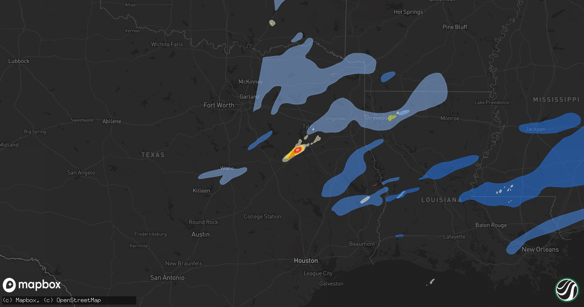
Hail Map on March 4, 2025
Get this storm
March 4 map
$229
one time, instant access
Download today. No call, no setup
Keep the $229
Bought the map and want the full workflow? Apply the entire $229 to a subscription within 7 days. None of it is wasted.
Every map, not just this one
This buys you this map. Subscription and you get every map we run, in the markets you choose from a few cities to whole states to nationwide. Plus real-time alerts the moment a storm fires.
Contact data
Name, contact info, occupancy, even credit band for addresses in the footprint. You go from where it hit to who to call.
Become the source they trust
Unlimited branding weather history reports on demand. You already have the documented answer ready for the property owner, and you are the one who showed up with it.
Property data and RoofTrace estimates
Pull up any address you have got, its value and the exact code rules for that jurisdiction, straight from One Click Code. Then RoofTrace estimates the squares, pitch, and roof value, priced the way you price.
States Impacted by Hail Map on March 4, 2025
Storm reports
Nebraska
| Date | Description |
|---|---|
| 03/04/202511:40 AM CST | Kgri. |
| 03/03/20258:20 PM CST | Report from mping: 1-inch tree limbs broken; shingles blown off. |
Alabama
| Date | Description |
|---|---|
| 03/04/20253:21 PM CST | Power lines down on wright drive in florence. |
| 03/04/20259:25 AM CST | Large trees down blocking old leeds road near irondale. Time estimated from radar. Via social media. |
| 03/04/202512:55 AM CST | Trees and powerlines reported down at white oak campground and along white oak creek. Time estimated from radar. |
| 03/04/202512:50 AM CST | Henry county dispatch reported a few trees down in the area of cr-7 & cr-80. |
| 03/04/202512:20 AM CST | Coffee county dispatch reported a tree down on cr-124. |
| 03/04/202512:00 AM CST | Coffee county dispatch reported a tree down on cr-107. |
| 03/04/202512:00 AM CST | Coffee county dispatch reported a tree down on cr-228. |
| 03/03/202511:57 PM CST | Coffee county dispatch reported a downed tree on cr-331. |
| 03/03/202511:52 PM CST | Coffee county dispatch reported a downed tree on cr-474. |
| 03/03/202511:15 PM CST | Trees down blocking most of the roadway at us highway 278 and county rd 181. Time estimated from radar. |
| 03/03/202511:13 PM CST | Tree down at highway 78 and county road 49. Another tree down on country road 49 near i-20. |
| 03/03/202511:00 PM CST | Multiple reports of trees down across northern cherokee county with multiple callouts to broomtown vfd to help clear trees from roadways. |
| 03/03/202510:48 PM CST | Multiple trees reported down blocking roadways across southern portions of calhoun county south of oxford. |
| 03/03/202510:47 PM CST | A couple trees down on highway 281 near highway 49. |
| 03/03/202510:45 PM CST | Trees down blocking both lanes of county rd 70 northwest of leesburg. Time estimated from radar. |
| 03/03/202510:45 PM CST | Tree down near cr 366. |
| 03/03/202510:45 PM CST | Minor roof damage sustained to a home in weaver. Sent via social media... Time estimated from radar. |
| 03/03/202510:40 PM CST | Tree down on iron mountain road. |
| 03/03/202510:40 PM CST | A more concentrated area of trees and powerlines were reported down near salt creek falls just west of mt. Cheaha. A large number of residents were without power. |
| 03/03/202510:30 PM CST | Trees down in the scottsboro area. |
| 03/03/202510:30 PM CST | Trees down in the scottsboro area. |
| 03/03/202510:30 PM CST | Single trees down in four different locations across the county. |
| 03/03/202510:28 PM CST | Trees reported down near bryant. |
| 03/03/202510:25 PM CST | Multiple trees and power lines reported down across talladega county caused by the line of storms that moved across the county between 930 and 11pm ct. |
| 03/03/202510:05 PM CST | Trees down near hwy 71 in pisgah. |
| 03/03/202510:00 PM CST | Barn heavily damaged off near douglas. |
| 03/03/202510:00 PM CST | Old open-sided chicken house collapsed... Trapping cows and damaging equipment. One cow was killed and a few others sustained injuries. Shingles blown off a residence a |
| 03/03/202510:00 PM CST | Trees down in far southern marshall co. |
| 03/03/202510:00 PM CST | Corrects time of previous tstm wnd dmg report from ashville. Multiple reports of trees down across the northern end of the county. |
| 03/03/20259:55 PM CST | Multiple trees and powerlines down in and around odenville... Including liberty road... Where a vehicle accident also occurred. No injuries reported. |
| 03/03/20259:53 PM CST | Tree in roadway. |
| 03/03/20259:50 PM CST | Trees reported down on hwy 79. |
| 03/03/20259:45 PM CST | Corrects previous tstm wnd dmg report from 3 ssw section. Tree down near cr 366. |
| 03/03/20259:43 PM CST | Tree blocking entire roadway. |
| 03/03/20259:42 PM CST | Tree and power pole down. |
| 03/03/20259:40 PM CST | Argo pd reported roulain road was impassible and closed due to trees and powerlines down. Time estimated from radar... Via social media. |
| 03/03/20259:40 PM CST | Tree down at cove spring rd and little cove rd. Also a tree down on bristow cove rd. |
| 03/03/20259:40 PM CST | An amateur radio antenna was bent over and damaged morningside drive. Time estimated by radar. |
| 03/03/20259:37 PM CST | Tree down across the road near county road 57 and county road 40. |
| 03/03/20259:35 PM CST | Multiple trees down in the vicinity of columbiana... Including kewaw drive... Atchison trace... Highway 47... Mcmahon highlands... And chelsea rd. |
| 03/03/20259:30 PM CST | Corrects previous tstm wnd dmg report from 7 nnw douglas. Trees reported down on hwy 79. |
| 03/03/20259:30 PM CST | Tree down county road 24 and county road 21. |
| 03/03/20259:30 PM CST | Trees down countywide. |
| 03/03/20259:20 PM CST | Large tree down on power lines blocking shades crest rd at erwin circle... With power lines snapped. Time estimated from radar... Via social media. |
| 03/03/20259:20 PM CST | Corrects previous tstm wnd dmg report from 3 wnw douglas. Barn heavily damaged off near douglas. |
| 03/03/20259:19 PM CST | Report from mping: 1-inch tree limbs broken; shingles blown off. |
| 03/03/20259:15 PM CST | Powerlines down on helena rd. |
| 03/03/20259:13 PM CST | Multiple reports of trees down across the northern end of the county. |
| 03/03/20259:10 PM CST | Power pole broken at cr 416 and cr 47. |
| 03/03/20259:05 PM CST | Multiple reports of trees down including cecil jackson bypass... River road... And cr 304. |
| 03/03/20258:58 PM CST | Asos station khsv huntsville. |
| 03/03/20258:50 PM CST | Trees reported down on i-65 at exit 287 blocking travel lanes. Via social media... Time estimated from radar. |
| 03/03/20258:38 PM CST | Trees down. |
| 03/03/20258:35 PM CST | Report from mping: 1-inch tree limbs broken; shingles blown off. |
| 03/03/20258:35 PM CST | Multiple trees down and power outages around marion and sprott. |
| 03/03/20258:28 PM CST | Tree down on sipsey rd. |
| 03/03/20258:26 PM CST | Tree down at bryan rd and ball park rd and on horse creek blvd. |
| 03/03/20258:20 PM CST | Tree down on smith lake dam rd. |
| 03/03/20258:15 PM CST | Report from mping: trees uprooted or snapped; roof blown off. |
| 03/03/20258:12 PM CST | Tree down on highway 269 at gorgas rd and on tutwiler road. |
| 03/03/20258:06 PM CST | Tree down on redmill saragossa rd. |
| 03/03/20257:30 PM CST | Tree down on mundy rd. |
| 03/03/20257:27 PM CST | Tree on a home. |
| 03/03/20257:19 PM CST | Powerlines down with a small fire. |
| 03/03/20257:13 PM CST | Corrects previous tstm wnd dmg report from 1 sse haleyville. Tree and power pole down. |
| 03/03/20257:10 PM CST | Tree down on new bethel rd. |
| 03/03/20257:08 PM CST | Tree down in york and also on mcelroy rd. |
Georgia
| Date | Description |
|---|---|
| 03/04/20254:00 AM CST | Tree reported down along hwy 319 s and mitchell store rd. |
| 03/04/20252:10 AM CST | Dispatch reported a tree down near hwy-200. |
| 03/04/20251:59 AM CST | Seminole so reported a tree on a powerline off burl lane rd & three notch rd. |
| 03/04/20251:35 AM CST | Early county dispatch reported a down tree in ric hall ln. |
| 03/04/20251:24 AM CST | A tree was downed into the roadway on ormewood ave se. |
| 03/04/20251:16 AM CST | Report of a tree down on a vehicle parked in a driveway on the 3500 block of union hill rd. |
| 03/04/20251:15 AM CST | Tree down on roadway. |
| 03/04/20251:10 AM CST | Report of trees and powerlines down along hwy 140 leading to a closure of the highway between canton and waleska for several hours. |
| 03/04/20251:08 AM CST | A large tree fell on turtle landing. |
| 03/04/20251:06 AM CST | Tree down near the intersection of upper burris road and fields mcghee drive. |
| 03/04/20251:04 AM CST | Report of a tree on a house on the 1800 block of ridge rd. |
| 03/04/20251:02 AM CST | Regional dispatch reported a down tree around east bank and 39 n. |
| 03/04/20251:02 AM CST | Tree down near the intersection of sam nelson road and talcmine drive. |
| 03/04/202512:58 AM CST | Tree down near the intersection of wyngate parkway and bells ferry road. |
| 03/04/202512:44 AM CST | Tree down near the intersection of mountain ridge se and redtop drive se. |
| 03/04/202512:40 AM CST | Powerlines downed by thunderstorm winds. |
| 03/04/202512:39 AM CST | Tree down along dingler road. |
| 03/04/202512:39 AM CST | Tree down on the road near the intersection of chadds and picketts ridge. |
| 03/04/202512:37 AM CST | Tree down at amlajack and bledsoe. |
| 03/04/202512:36 AM CST | Tree down on the road at tidwell rd and hiram douglasville highway. |
| 03/04/202512:35 AM CST | Corrects previous tstm wnd dmg report from 1 sw madras. Tree down near highway 29 and sunny brook. |
| 03/04/202512:31 AM CST | Tree down on powerlines along blackhawk trail. |
| 03/04/202512:26 AM CST | Report of powerlines downed by thunderstorms winds. |
| 03/04/202512:25 AM CST | Report of power lines down at county line church rd and stovall rd. |
| 03/04/202512:20 AM CST | Report of at least two trees down on hogansville rd... Between ralls rd and trimble station rd. |
| 03/04/202512:20 AM CST | Report of a tree down on the 700 block of stewart rd. |
| 03/04/202512:19 AM CST | Tree down near wagers mill and highway 16. |
| 03/04/202512:19 AM CST | Tree blocking the road near the intersection of winn road and bobby austin road. |
| 03/04/202512:18 AM CST | Tree blocking the roadway near the intersection of ray lee road and ridge road. |
| 03/04/202512:17 AM CST | Report of a tree down on the 200 block of hightower rd. |
| 03/04/202512:16 AM CST | Tree down on the road at ray cole road and georgian parkway. |
| 03/04/202512:15 AM CST | Tree down along flatbottom road. |
| 03/04/202512:13 AM CST | Report of a tree down on the 1300 block of dennis smith rd. |
| 03/04/202512:13 AM CST | Multiple trees down in villa rica. |
| 03/04/202512:12 AM CST | Report of at least two power lines down near the intersection of hogansville rd and n/s davis rd. |
| 03/04/202512:10 AM CST | Two trees down in the city of whitesburg. |
| 03/04/202512:10 AM CST | Tree down near the intersection of arnold mill road and hendon road. |
| 03/04/202512:05 AM CST | Tree down on the road near the intersection of wilson road and mcgarity road. |
| 03/04/202512:05 AM CST | Tree down on a house along sandhill shady grove road. |
| 03/04/202512:00 AM CST | Strong wind gust at the cohutta raws station. |
| 03/04/202512:00 AM CST | Report of power lines down on the 200 block of westside ct. |
| 03/03/202511:58 PM CST | Report of a tree down at mooty bridge rd and lovic davis rd. |
| 03/03/202511:57 PM CST | Multiple trees down in the city of carrollton. |
| 03/03/202511:57 PM CST | Tree down near the intersection of big oak tree road nw and plantation road nw. |
| 03/03/202511:55 PM CST | Tree down at intersection. |
| 03/03/202511:55 PM CST | Tree down on house along cedar heights road. |
| 03/03/202511:55 PM CST | Report of a large tree down off of hwy 278 on the west side of rockmart. |
| 03/03/202511:55 PM CST | Tree down along sewell road. |
| 03/03/202511:53 PM CST | 1 tree down. |
| 03/03/202511:52 PM CST | Report of a tree down on the 1200 block of antioch rd. |
| 03/03/202511:49 PM CST | Tree down. |
| 03/03/202511:49 PM CST | Tree down. |
| 03/03/202511:46 PM CST | 1 tree down. |
| 03/03/202511:35 PM CST | Tree down. |
| 03/03/202511:35 PM CST | Tree down along smithfield road. |
| 03/03/202511:33 PM CST | Report of multiple trees down across a subdivision at bryant circle and pinecrest rd. One tree fell through a house. |
| 03/03/202511:27 PM CST | The roof was partially blown off of a building at sikes storey lumber yard... Off of sikes storey rd. |
| 03/03/202511:17 PM CST | Multiple trees down in ringgold. |
| 03/03/202511:15 PM CST | Report of a tree down off of ramey st. |
| 03/03/202511:05 PM CST | Powerline down along colony circle road. |
| 03/03/202511:03 PM CST | Two trees down on roadways. One tree near the intersection of farming rock road and lee clarkson road. One tree down along red belt road. |
| 03/03/202511:03 PM CST | Tree down in roadway. |
| 03/03/202510:38 PM CST | A tree fell across the 600 block of slygo road. |
| 03/03/202510:35 PM CST | A tree fell across the 4000 block of brow road and blocked both lanes. |
Tennessee
| Date | Description |
|---|---|
| 03/03/20258:55 PM CST | Several trees were blown down in eagleville. |
Kansas
| Date | Description |
|---|---|
| 03/03/20256:36 PM CST | Report from mping: 1-inch tree limbs broken; shingles blown off. |
Florida
| Date | Description |
|---|---|
| 03/04/20254:00 AM CST | Fallen trees or limbs resulted in a power outage along bloxham cutoff road. |
| 03/04/20253:57 AM CST | Fallen trees or limbs resulted in a power outage along smith creek road northwest of sopchoppy. |
| 03/04/20253:00 AM CST | Gadsden county dispatch reported a powerline on a tree that sparked a fire on the limb. |
| 03/04/20252:02 AM CST | Calhoun county dispatch reported a down tree at macedonia church rd off sr-69a. |
| 03/04/202512:30 AM CST | Holmes county dispatch reported a down tree on westville park off hwy-90. |
| 03/04/202512:30 AM CST | Washington county dispatch reported a tree down on hwy-79 and millers ferry rd. |
| 03/04/202512:20 AM CST | Holmes county dispatch reported a down tree on morrow rd off hwy-90. |
| 03/04/202512:00 AM CST | Walton county so reported several trees and powerlines down on bob sikes rd off 285. |
| 03/03/202511:20 PM CST | Reported by navarre weatherstem station. |
| 03/03/202511:07 PM CST | Mino soffit and shingle damage to a home on champagne ave. |
| 03/03/202511:06 PM CST | The tornado touched down along champagne ave... Causing minor shingle damage to several homes. As it crossed a culdesac at champagne ave... A metal awning was destroyed |
| 03/03/202510:54 PM CST | Reported by kpns pensacola international airport. |
| 03/03/202510:40 PM CST | Recorded at knpa - pensacola nas. |
Texas
| Date | Description |
|---|---|
| 03/04/202512:52 PM CST | Report from mping: 1-inch tree limbs broken; shingles blown off. |
| 03/04/202512:07 PM CST | Report from mping: 1-inch tree limbs broken; shingles blown off. |
| 03/04/202511:31 AM CST | Report from mping: trees uprooted or snapped; roof blown off. |
| 03/04/202511:28 AM CST | Report from mping: trees uprooted or snapped; roof blown off. |
| 03/04/202511:09 AM CST | Kfdm mesonet. |
| 03/04/202510:50 AM CST | Trees and power lines reported down by ham radio. |
| 03/04/202510:39 AM CST | Reports of trees and powerlines down... Concentrated in area surrounding shawnee shore rd. |
| 03/04/202510:38 AM CST | Trees and power lines reported down by ham radio. |
| 03/04/202510:30 AM CST | Clustering of trees down in usfs land. Possible tornado. |
| 03/04/202510:12 AM CST | Local emergency management reports tree down on hwy 92 near dam b. Time estimated from radar. |
| 03/04/202510:12 AM CST | Reports of trees down throughout huxley. |
| 03/04/202510:08 AM CST | Mesonet station hcft2 harris county flood control at b. |
| 03/04/20259:57 AM CST | Emergency manager reports a tree down on fm 256 e. Time estimated from radar. |
| 03/04/20259:50 AM CST | The tornado began roughly 0.5 miles west of hwy 287 where several trees were damaged along with some outbuildings. The tornado then continued northeast where it damaged |
| 03/04/20259:19 AM CST | Measured at the angelina county airport near burke. |
| 03/04/20259:18 AM CST | Report from mping: roof blown off. |
| 03/04/20258:35 AM CST | Broadcast media reported structure damage along fm 230 in houston county. |
| 03/04/20258:23 AM CST | Report from mping: 1-inch tree limbs broken; shingles blown off. |
| 03/04/20258:20 AM CST | 911 call of multiple trees down along block county road 4105. |
| 03/04/20258:20 AM CST | Report of trees and powerlines down over n holiday blvd in overton... Tx. |
| 03/04/20258:15 AM CST | Sh 294 was closed near the cherokee county line due to five large downed trees. Time estimated via radar. |
| 03/04/20258:13 AM CST | Report of trees down near the intersection of sh 42 and fm 850. Including a tree fallen on fm 850 blocking the road. |
| 03/04/20258:08 AM CST | Reports of structures damaged in new boston. |
| 03/04/20258:00 AM CST | Reports of roofs taken off houses in de kalb. No specific locations given. |
| 03/04/20257:55 AM CST | Report from mping: 3-inch tree limbs broken; power poles broken. |
| 03/04/20257:44 AM CST | Tree down on a vehicle in cason. |
| 03/04/20257:41 AM CST | Report from mping: 1-inch tree limbs broken; shingles blown off. |
| 03/04/20257:38 AM CST | Report from mping: 3-inch tree limbs broken; power poles broken. |
| 03/04/20257:38 AM CST | Reports of overturned camper trailers at bigal barefoot bay north of rochy mound... Tx. Unknown number of injuries reported. |
| 03/04/20257:35 AM CST | Report from mping: 3-inch tree limbs broken or power poles broken. |
| 03/04/20257:35 AM CST | Measured at the mount pleasant regional airport. |
| 03/04/20257:30 AM CST | Images of measured three inch hailstone. Two other hailstones in photo approximately golf ball sized. |
| 03/04/20257:30 AM CST | Spotter reported power line down on top of a car near intersection of kinsey dr and loop 323 |
| 03/04/20257:26 AM CST | Roof damage was reported in the elmwood area near acr 445. Time estimated via radar. |
| 03/04/20257:23 AM CST | Storm spotter report of trees down near 344 and 346 |
| 03/04/20257:00 AM CST | Report from mping: 1-inch tree limbs broken; shingles blown off. |
| 03/04/20257:00 AM CST | Report from mping: 3-inch tree limbs broken or power poles broken. |
| 03/04/20257:00 AM CST | Report from mping: 1-inch tree limbs broken; shingles blown off. |
| 03/04/20256:53 AM CST | Tree damage reported on highway 164... Fm 3371... And s fm 39 in limestone county. |
| 03/04/20256:50 AM CST | Reports of trees on houses in canton and numerous trees down across van zandt county. Time estimated via radar. |
| 03/04/20256:50 AM CST | 61 mph wind gust measured at the kslr awos. |
| 03/04/20256:50 AM CST | Major structural damage reported near cr 4759 and cr 4760... Including structural damage... Tree damage... And downed power lines. |
| 03/04/20256:48 AM CST | Images of roof of small building removed... Trees snapped. Partial loss of roof decking on home. Time estimated via radar. |
| 03/04/20256:46 AM CST | 62 mph wind gust reported by a cwop site in blooming grove. |
| 03/04/20256:45 AM CST | Broadcast media reported damage in somerville around the school campus. One home sustained major damage from a fallen tree. One vehicle was damaged by a fallen tree. No |
| 03/04/20256:44 AM CST | Damage to trees... Carports... And awnings was reported in rains county. Time estimated via radar. |
| 03/04/20256:42 AM CST | 59 mph wind gust measured at the kcrs asos. |
| 03/04/20256:42 AM CST | Minor damage to siding on home. Snapped flag pole and tree branches. |
| 03/04/20256:32 AM CST | A metal southwest facing wall of a pole barn was blown down at a residence off of county road 1600 near county road 1609. |
| 03/04/20256:32 AM CST | Shoe store building collapsed at 4th st and high st in wills point. |
| 03/04/20256:30 AM CST | Multiple accidents including an overturned 18 wheeler in commerce. |
| 03/04/20256:29 AM CST | Report from mping: trees uprooted or snapped or roof blown off. |
| 03/04/20256:26 AM CST | Multiple homes with shingles missing and fences blown over. Metal barn building collapsed and roof is missing. Nearby powerlines blown over and snapped approximately 10 |
| 03/04/20256:26 AM CST | Multiple trees down and roof off of one house in commerce. |
| 03/04/20256:25 AM CST | Multiple power poles down and road closed at old robinson rd and us 77. |
| 03/04/20256:25 AM CST | Overturned 18 wheeler reported on westbound pgbt near marsh ln. |
| 03/04/20256:20 AM CST | Downed tree on an rv at bonham state park. |
| 03/04/20256:19 AM CST | Multiple power poles down along highway 77 in robinson. Tree damage reported near n andrews st. |
| 03/04/20256:17 AM CST | Major roof damage reported at a large commercial warehouse in the 900 block of s airport dr. |
| 03/04/20256:12 AM CST | 65 mph wind gust reported in woodway. |
| 03/04/20256:10 AM CST | 61 mph wind gust measured by the bonham jones field awos. |
| 03/04/20256:05 AM CST | 72 mph wind gust reported in trenton. |
| 03/04/20256:05 AM CST | Nickel size hail reported in bells. |
| 03/04/20256:05 AM CST | Six downed power poles along nb dallas parkway near texas health frisco. |
| 03/04/20256:02 AM CST | Images of partial loss of roof decking to home. Sporadic tree damage and small metal outbuilding destroyed. |
Arkansas
| Date | Description |
|---|---|
| 03/04/20254:46 PM CST | Large tree limb reported in the road - near hwy 10 and washburn mountain loop area; time estimated by radar. |
| 03/04/202512:12 PM CST | Report of a measured wind gust of 61 mph along meadows rd in texarkana... Ar. |
| 03/04/202510:35 AM CST | Report of a large tree uprooted on a house at the intersection of sixth st and calion rd. |
| 03/04/20259:14 AM CST | Reports of fallen tree limbs and damage to several chicken houses at the intersection of cr 19 and cr 21. |
| 03/04/20259:10 AM CST | Hempstead county sheriff office received a report of trees down on hempstead 185 near hwy 278 w just outside of the town of old washington. |
| 03/04/20258:55 AM CST | Howard county sheriff office received report of a tree limb down on a home on w sunset st in nashville. |
| 03/04/20258:41 AM CST | Reports of multiple trees down in genoa. |
| 03/04/20258:30 AM CST | 911 dispatch center in sevier county received reports of multiple trees down on frog level road... Southeast of horatio. |
| 03/04/20258:20 AM CST | Little river sherriff office received reports of several trees down; near the intersection of ar 41 s and ar 32 w and along ar-32 w near the town of wallace... Ar. |
| 03/04/20258:20 AM CST | Little river sheriff office received report of a blown over tractor trailer near the intersection of ar 41 s and little river 4. |
| 03/04/20257:53 AM CST | Power poles down... Barn roof torn off. |
Mississippi
| Date | Description |
|---|---|
| 03/04/20255:50 PM CST | A few trees down and some power lines in the central parts of the county. Rose ln and buffalo hill rd. |
| 03/04/20255:45 PM CST | Tree downed along cr 812. |
| 03/04/20255:38 PM CST | Tree downed on archie smith rd. |
| 03/04/20255:03 PM CST | Tree down on old hwy 24 west. |
| 03/04/20254:55 PM CST | A few trees down scattered about as the line of storms moved through. |
| 03/04/20254:54 PM CST | Tree down on w reservoir rd. |
| 03/04/20254:33 PM CST | A few trees down in the county. |
| 03/04/20254:22 PM CST | Tree down. |
| 03/04/20254:03 PM CST | Roof damage to a storm |
| 03/04/20253:52 PM CST | Couple trees down on roads in the s part of the county. |
| 03/04/20253:19 PM CST | Report from mping: 3-inch tree limbs broken. |
| 03/04/20253:16 PM CST | A couple trees down. |
| 03/04/20253:07 PM CST | 70mph wind gust measured with anemometer. Intersection of hwy 18 and hwy 80. |
| 03/04/20252:58 PM CST | A couple trees down. |
| 03/04/20252:37 PM CST | Tree down on hinds blvd blocking road. |
| 03/04/20252:04 PM CST | Tree down in town. |
| 03/04/20251:43 PM CST | A few trees down in town... One on a home. |
| 03/03/20257:55 PM CST | An ef1 tornado began near the intersection of marshall smith road and cooks corner road where a farm building was completely destroyed on the west side of the road. On |
| 03/03/20257:05 PM CST | Thunderstorm winds downed power lines across northern portions of hancock county near necaise. |
| 03/03/20256:47 PM CST | Trees downed around the 100 block of old hwy 49 s. |
| 03/03/20256:30 PM CST | Significant structural damage reported near whistler. Likely tornado based on radar tds. |
| 03/03/20256:30 PM CST | Significant structural damage reported near whistler. Likely tornado based on radar tds. |
| 03/03/20256:30 PM CST | Scattered trees down in the county. |
| 03/03/20256:24 PM CST | *** 4 inj *** the tornado began in the forested area near earl pitts rd before rapidly strengthening as it crossed highway 84. A single vehicle was rolled in a parking |
| 03/03/20256:20 PM CST | Large tree downed in front of house on poplar springs drive... Between 23rd and 24th street. |
| 03/03/20256:18 PM CST | Corrects previous tstm wnd gst report from hattiesburg. 58 mph wind gust measured at hbg airport. |
| 03/03/20256:18 PM CST | 58 mph wind gust measured at hbg airport. |
| 03/03/20256:18 PM CST | Corrects previous tstm wnd gst report from hattiesburg. 58 mph wind gust measured at hbg airport. |
| 03/03/20256:15 PM CST | Tree and powerlines downed on cal bonner dr. |
| 03/03/20256:13 PM CST | Tree downed at the intersection of timber lakes dr and thagard dr. |
Louisiana
| Date | Description |
|---|---|
| 03/04/20255:59 PM CST | Tree down causing additional damage to power pole near intersection of foy and dupard. |
| 03/04/20255:15 PM CST | Roof and tree damage on n nobile st in paulina. |
| 03/04/20255:15 PM CST | Dam |
| 03/04/20255:15 PM CST | Damage around the 1100 block of north airline ave in gramercy with continued damage to the east as well. |
| 03/04/20254:52 PM CST | Roof damage along river rd/hwy 942 in darrow. |
| 03/04/20254:25 PM CST | Multiple powerlines were downed by thunderstorm winds west of kentwood. |
| 03/04/20252:42 PM CST | Report from mping: 1-inch tree limbs broken; shingles blown off. |
| 03/04/20252:35 PM CST | West feliciana emergency management reported multiple trees down on along highway 10 northeast of st. Francisville. |
| 03/04/20252:27 PM CST | West feliciana emergency management reported multiple trees down on highway 421 east of highway 61. |
| 03/04/20251:00 PM CST | At the jonesville mesonet station. |
| 03/04/202512:55 PM CST | Near lana ln and hwy 3165... Trees down and a farm shed damaged. |
| 03/04/202512:45 PM CST | Roof blown off a building downtown. |
| 03/04/202512:28 PM CST | Pictures of several trees blown down from cenlaweather. |
| 03/04/202512:28 PM CST | Couple trees down. |
| 03/04/202512:28 PM CST | Gutters blown down and a 5 inch diameter tree snapped at that location. From cenlaweather meteorologist. |
| 03/04/202512:27 PM CST | Report from mping: 1-inch tree limbs broken; shingles blown off. |
| 03/04/202512:10 PM CST | A large tree was downed across highway 117 near the intersection of highway 478 in the vowells mill community. |
| 03/04/202512:06 PM CST | A tree was downed across miller road. |
| 03/04/202511:58 AM CST | A tree was downed across highway 139. |
| 03/04/202511:52 AM CST | The boyce tornado began between hwy 49 and hwy 1 in rapides parish... Where it downed several power lines. From there it continued northeast where it damaged homes as i |
| 03/04/202511:52 AM CST | Reports of damage in the boyce area. This may have been a tornado and will be surveyed tomorrow. |
| 03/04/202511:27 AM CST | Awos station kpoe fort polk fr. |
| 03/04/202511:24 AM CST | A tree was downed onto a power line across william basco road near the derry community. |
| 03/04/202511:24 AM CST | Utility lines were downed across highway 119 near longleaf vista road. |
| 03/04/202511:24 AM CST | Report from mping: 1-inch tree limbs broken; shingles blown off. |
| 03/04/202511:22 AM CST | Overturn trailer reported on base. 70 mph reported at the airfield at the time. |
| 03/04/202511:20 AM CST | Powerlines down. |
| 03/04/202511:12 AM CST | Multiple trees down on homes on mary street just north of natchitoches. |
| 03/04/202511:10 AM CST | Report from mping: 3-inch tree limbs broken; power poles broken. |
| 03/04/202511:05 AM CST | Large tree on train tracks in anacoco area. |
| 03/04/202511:02 AM CST | Photos received via social media showing an area of trees damaged. Several trees and power poles are snapped off 10 to 20 feet off of the ground. Possible tornado. Loca |
| 03/04/202510:59 AM CST | Picture of limbs down. One landed on a vehicle. |
| 03/04/202510:40 AM CST | Trees down with one fallen over highway 3121. |
| 03/04/202510:00 AM CST | Reports of multiple trees down around the intersection of hwy 80 and hwy 532. |
| 03/04/20259:27 AM CST | Straight-line winds estimated at 85 mph uplifted most of the roof of an outbuilding. |
| 03/04/20259:24 AM CST | Light post blown down at car dealership in north bossier city. |
| 03/04/20259:24 AM CST | Light post blown down at car dealership in north bossier city. |
| 03/04/20259:24 AM CST | Social media report of trees down near the shreveport hilton on n spring st. |
| 03/04/20259:22 AM CST | Measured at wfo shv by asos. |
| 03/04/20259:19 AM CST | This brief ef1 tornado touched down in the north highlands neighborhood of north shreveport. It initially began along booth drive and move east snapping the trunks of a |
| 03/04/20259:00 AM CST | This ef1 tornado began just east of the texas/louisiana state line in caddo parish and generally moved east along blanchard furrh road. Most of the damage consisted of |
| 03/03/20257:31 PM CST | Power poles down in the 26100 block of hwy 23 near port sulphur. |
| 03/03/20257:28 PM CST | Power pole damage near the courthouse in pointe a la hache. |
| 03/03/20256:38 PM CST | Large tree branches down on oak grove way in slidell. |
| 03/03/20256:09 PM CST | Wind gusts near mandeville estimated between 60 and 70 mph. |
| 03/03/20256:05 PM CST | Weatherflow mandeville observation recorded a 58 mph wind gust. |
Oklahoma
| Date | Description |
|---|---|
| 03/04/20254:10 PM CST | M-ping report - 1-inch tree limbs broken; time estimated by radar. |
| 03/04/20257:53 AM CST | Corrects previous tstm wnd dmg report. Power poles down... Barn roof torn off. |
| 03/04/20257:30 AM CST | Trees down at the wright city park. |
| 03/04/20257:09 AM CST | A local report indicates 58 MPH wind near 2 SW Wilburton |
| 03/04/20256:57 AM CST | Power lines down. |
| 03/04/20256:51 AM CST | This tornado snapped large tree limbs... Damaged the roof of a home... And blew the roof off an outbuilding. This tornado was rated ef-0 with maximum wind of 80 to 85 m |
| 03/04/20256:50 AM CST | A local report indicates 58 MPH wind near 2 NW Hugo |
| 03/04/20256:36 AM CST | A local report indicates 60 MPH wind near Eufaula |
| 03/04/20256:30 AM CST | A local report indicates 65 MPH wind near Checotah |
| 03/04/20256:30 AM CST | Power lines down. |
| 03/04/20256:25 AM CST | This tornado snapped large tree limbs and damaged the roof of a home. This tornado was rated ef-0 with maximum wind of 75 to 80 mph based on the damage. |
| 03/04/20256:23 AM CST | This tornado rolled an rv... Snapped large tree limbs... Damaged the roof of a home... And snapped several power poles. This tornado was rated ef-1 with maximum wind of |
| 03/04/20256:10 AM CST | This tornado snapped several trees on new lake road... Crossed i-40... And damaged several outbuildings on holly road. This tornado was rated ef-1 with maximum wind of |
| 03/04/20256:10 AM CST | This tornado snapped several trees on new lake road... Crossed i-40... And damaged several outbuildings on holly road. This tornado was rated ef-1 with maximum wind of ( |
| 03/04/20256:08 AM CST | This tornado snapped and uprooted trees at the henryetta golf and country club... And damaged several outbuildings. Homes were damaged and outbuildings were destroyed w |
Cities Impacted by Hail Map on March 4, 2025
- Weleetka, OK
- Lamar, OK
- Wetumka, OK
- Dustin, OK
- Holdenville, OK
- Mcalester, OK
- Stuart, OK
- Kiowa, OK
- Wardville, OK
- Eufaula, OK
- Hanna, OK
- Indianola, OK
- Krebs, OK
- Savanna, OK
- Blanco, OK
- Caney, OK
- Atoka, OK
- Columbia, MO
- Auxvasse, MO
- Clearwater, NE
- Crowder, OK
- Canadian, OK
- Henryetta, OK
- Checotah, OK
- Council Hill, OK
- Boynton, OK
- Oktaha, OK
- Coalgate, OK
- Calvin, OK
- Pittsburg, OK
- Seagoville, TX
- Leonard, TX
- Ravenna, TX
- Forney, TX
- Trenton, TX
- Whitewright, TX
- Bonham, TX
- Celeste, TX
- Savoy, TX
- Randolph, TX
- Royse City, TX
- Blue Ridge, TX
- Nevada, TX
- Ector, TX
- Crandall, TX
- Rockwall, TX
- Farmersville, TX
- Lavon, TX
- Caddo Mills, TX
- Terrell, TX
- Greenville, TX
- Bailey, TX
- Wolfe City, TX
- Windom, TX
- Cooper, TX
- Brashear, TX
- Campbell, TX
- Klondike, TX
- Ladonia, TX
- Dodd City, TX
- Cumby, TX
- Sulphur Springs, TX
- Pecan Gap, TX
- Commerce, TX
- Honey Grove, TX
- Dike, TX
- Enloe, TX
- Roxton, TX
- Paris, TX
- Ben Franklin, TX
- Telephone, TX
- Petty, TX
- Sumner, TX
- Brookston, TX
- Lake Creek, TX
- Lone Oak, TX
- Point, TX
- Wills Point, TX
- Quinlan, TX
- Emory, TX
- Yantis, TX
- Mineola, TX
- Alba, TX
- Quitman, TX
- Como, TX
- Winnsboro, TX
- Pickton, TX
- Blossom, TX
- Pattonville, TX
- Sulphur Bluff, TX
- Saltillo, TX
- Deport, TX
- Muskogee, OK
- Haskell, OK
- Braggs, OK
- Warner, OK
- Hugo, OK
- Fort Gibson, OK
- Wagoner, OK
- Porter, OK
- Taft, OK
- Oakwood, TX
- Palestine, TX
- Tennessee Colony, TX
- Haileyville, OK
- Hartshorne, OK
- Wilburton, OK
- Red Oak, OK
- Overbrook, OK
- Roff, OK
- Tupelo, OK
- Centrahoma, OK
- Fittstown, OK
- Stonewall, OK
- Ada, OK
- Mannsville, OK
- Davis, OK
- Marietta, OK
- Wapanucka, OK
- Konawa, OK
- Sulphur, OK
- Lone Grove, OK
- Dougherty, OK
- Allen, OK
- Tishomingo, OK
- Springer, OK
- Atwood, OK
- Sasakwa, OK
- Ardmore, OK
- Fitzhugh, OK
- Milburn, OK
- Mill Creek, OK
- Hinton, OK
- Butler, OK
- Sharon, OK
- Hennessey, OK
- Hitchcock, OK
- Dill City, OK
- Thomas, OK
- Arapaho, OK
- Chester, OK
- Anadarko, OK
- Foss, OK
- Eldorado, OK
- Rocky, OK
- Colony, OK
- Greenfield, OK
- Hydro, OK
- Vici, OK
- Mooreland, OK
- Clinton, OK
- Cordell, OK
- Hollis, OK
- Custer City, OK
- Childress, TX
- Canute, OK
- Okarche, OK
- Binger, OK
- Olustee, OK
- Carter, OK
- Drummond, OK
- Camargo, OK
- Quanah, TX
- Calumet, OK
- Canton, OK
- Sayre, OK
- Gracemont, OK
- Hobart, OK
- Watonga, OK
- Geary, OK
- Ames, OK
- Oakwood, OK
- Fairview, OK
- Kingfisher, OK
- Gould, OK
- Lookeba, OK
- Mountain Park, OK
- Carnegie, OK
- Duke, OK
- Bison, OK
- Mangum, OK
- Blair, OK
- Roosevelt, OK
- Lawton, OK
- Omega, OK
- Granite, OK
- Leedey, OK
- Loyal, OK
- Taloga, OK
- Mountain View, OK
- Willow, OK
- Sentinel, OK
- Putnam, OK
- Southard, OK
- Hammon, OK
- Elk City, OK
- Lone Wolf, OK
- Mutual, OK
- Headrick, OK
- Bessie, OK
- Fort Cobb, OK
- Waukomis, OK
- Corn, OK
- Weatherford, OK
- Minco, OK
- Okeene, OK
- Dover, OK
- Longdale, OK
- Seiling, OK
- Gotebo, OK
- El Reno, OK
- Altus, OK
- Fay, OK
- Kemp, TX
- Frankston, TX
- Tyler, TX
- Bullard, TX
- Flint, TX
- Jacksonville, TX
- Hulbert, OK
- Whitehouse, TX
- Talco, TX
- Winfield, TX
- Detroit, TX
- Leesburg, TX
- Mount Pleasant, TX
- Pittsburg, TX
- Scroggins, TX
- Mount Vernon, TX
- Bogata, TX
- Clarksville, TX
- Overton, TX
- Winona, TX
- Kilgore, TX
- Arp, TX
- Longview, TX
- White Oak, TX
- Gladewater, TX
- Hallsville, TX
- Harleton, TX
- Gilmer, TX
- Diana, TX
- Ore City, TX
- Troup, TX
- Lone Star, TX
- Avinger, TX
- Jefferson, TX
- Henderson, TX
- Tatum, TX
- Marshall, TX
- Karnack, TX
- Beckville, TX
- Waskom, TX
- Shreveport, LA
- Mooringsport, LA
- Diboll, TX
- Lufkin, TX
- Apple Springs, TX
- Corrigan, TX
- Groveton, TX
- Huntington, TX
- Greenwood, LA
- Bethany, LA
- Keithville, LA
- Blanchard, LA
- De Berry, TX
- Bossier City, LA
- Haughton, LA
- Barksdale Afb, LA
- Stonewall, LA
- Frierson, LA
- Etoile, TX
- Nacogdoches, TX
- Chireno, TX
- Timpson, TX
- Center, TX
- Tenaha, TX
- San Augustine, TX
- Zavalla, TX
- Livingston, TX
- Chester, TX
- Moscow, TX
- Woodville, TX
- Elm Grove, LA
- Princeton, LA
- Minden, LA
- Joaquin, TX
- Colmesneil, TX
- Shelbyville, TX
- Logansport, LA
- Broaddus, TX
- Doyline, LA
- Warren, TX
- Ringgold, LA
- Bronson, TX
- Grand Cane, LA
- Mansfield, LA
- Sibley, LA
- Heflin, LA
- Dubberly, LA
- Gibsland, LA
- Athens, LA
- Homer, LA
- Jasper, TX
- Arcadia, LA
- Princeton, TX
- Mesquite, TX
- Newton, TX
- Wiergate, TX
- Dubach, LA
- Bernice, LA
- Lillie, LA
- Spearsville, LA
- Farmerville, LA
- Marion, LA
- Florien, LA
- Anacoco, LA
- Hornbeck, LA
- Deridder, LA
- Evans, LA
- Leesville, LA
- Fort Polk, LA
- Pitkin, LA
- Boyce, LA
- Colfax, LA
- Dry Prong, LA
- Sulphur, LA
- Lake Charles, LA
- Westlake, LA
- Kaufman, TX
- Simmesport, LA
- Moreauville, LA
- Plaucheville, LA
- Lettsworth, LA
- Woodville, MS
- Monterey, LA
- Batchelor, LA
- Angola, LA
- Saint Francisville, LA
- Gloster, MS
- Centreville, MS
- Waco, TX
- Woodway, TX
- McGregor, TX
- Oglesby, TX
- Crawford, TX
- Gatesville, TX
- Hewitt, TX
- Lorena, TX
- Moody, TX
- Chilton, TX
- Marlin, TX
- Riesel, TX
- Groesbeck, TX
- Mart, TX
- Bruceville, TX
- Eddy, TX
- Troy, TX
- Crosby, MS
- Norwood, LA
- Purdon, TX
- Dawson, TX
- Corsicana, TX
- Powell, TX
- Kerens, TX
- Liberty, MS
- Trinidad, TX
- Mabank, TX
- Jackson, LA
- Wilson, LA
- Clinton, LA
- Hemphill, TX
- Magnolia, MS
- Smithdale, MS
- Mccomb, MS
- Summit, MS
- Lisbon, LA
- Haynesville, LA
- Junction City, AR
- Summerfield, LA
- El Dorado, AR
- Hampton, AR
- Calion, AR
- Strong, AR
- Jersey, AR
- Huttig, AR
- Edwards, MS
- Bolton, MS
- Raymond, MS
- Jackson, MS
- Byram, MS
- Richland, MS
- Flowood, MS
- Clinton, MS
- Pearl, MS
- Tougaloo, MS
- Brandon, MS
- Ridgeland, MS
- Ethel, LA
- Greensburg, LA
- Kentwood, LA
- Osyka, MS
- Bogue Chitto, MS
- Mount Hermon, LA
- Lena, LA
- Pelahatchie, MS
- Morton, MS
- Lena, MS
- Pineville, LA
- Forest, MS
- Pulaski, MS
- Conehatta, MS
- Walnut Grove, MS
- Bentley, LA
- Pollock, LA
- Trout, LA
- Jena, LA
- Ball, LA
- Alexandria, LA
- Deville, LA
- Jonesville, LA
- Sicily Island, LA
- Harrisonburg, LA
- Lake, MS
- Hineston, LA
- Tylertown, MS
- Jayess, MS
- Ruth, MS
- Sieper, LA
- Ferriday, LA
- Clayton, LA
- Newton, MS
- Decatur, MS
- Lawrence, MS
- Union, MS
- Sebastopol, MS
- Philadelphia, MS
- Franklinton, LA
- Monticello, MS
- Kokomo, MS
- Foxworth, MS
- Brookhaven, MS
- Oak Vale, MS
- Silver Creek, MS
- Fluker, LA
- Amite, LA
- Columbia, MS
- Prentiss, MS
- Magee, MS
- Collins, MS
- Mount Olive, MS
- Carson, MS
- Newhebron, MS
- Mendenhall, MS
- Raleigh, MS
- Pinola, MS
- Mize, MS
- Bassfield, MS
- Seminary, MS
- Sumrall, MS
- Lumberton, MS
- Taylorsville, MS
- Soso, MS
- Purvis, MS
- Petal, MS
- Hattiesburg, MS
- Moselle, MS
- Ellisville, MS
- Bay Springs, MS
- Little Rock, MS
- Enterprise, MS
- Heidelberg, MS
- Laurel, MS
- Collinsville, MS
- Chunky, MS
- Stringer, MS
- Paulding, MS
- Meridian, MS
- Louin, MS
- Vossburg, MS
- Hickory, MS
- Rose Hill, MS
- Waynesboro, MS
- Pachuta, MS
- Ovett, MS
- Shubuta, MS
- Daleville, MS
- Quitman, MS
- Richton, MS
- Toomsuba, MS
- Bailey, MS
- Marion, MS
- Lauderdale, MS
- Stonewall, MS
- Thibodaux, LA
- Vacherie, LA
- Gramercy, LA
- Paulina, LA
- Convent, LA
- Saint James, LA
- Garyville, LA
- Lutcher, LA
- Reserve, LA
- La Place, LA
- Mount Airy, LA
- Edgard, LA
- Hahnville, LA
- Covington, LA
- Ponchatoula, LA
- Madisonville, LA
- Mandeville, LA
- Lacombe, LA
- Poplarville, MS
- Kiln, MS
- Gulfport, MS
- Lucedale, MS
- Pearl River, LA
- Vancleave, MS
- Picayune, MS
- Saucier, MS
- Stennis Space Center, MS
- Carriere, MS
- Pass Christian, MS
- Slidell, LA
- McHenry, MS
- Perkinston, MS
- Abita Springs, LA
- Bay Saint Louis, MS
- Biloxi, MS
- Bush, LA
- Wilmer, AL
- Citronelle, AL
- New Augusta, MS
- Toxey, AL
- Butler, AL
- Melvin, AL
- Silas, AL
- Cuba, AL
- Lisman, AL
- Porterville, MS
- York, AL
- Needham, AL
- Gilbertown, AL
- Jachin, AL
- Ward, AL
- State Line, MS
- Leakesville, MS
- Buckatunna, MS
- Deer Park, AL
- Beaumont, MS
- Coffeeville, AL
- Leroy, AL
- Jackson, AL
- Fruitdale, AL
- Wagarville, AL
- Chatom, AL
- Saint Stephens, AL
- Campbell, AL
- Thomasville, AL
- Frankville, AL
- Tibbie, AL
- Millry, AL
- Chunchula, AL
- Sweet Water, AL
- Whatley, AL
- Grove Hill, AL
- Dickinson, AL
- Vinegar Bend, AL
- Neely, MS
- Arley, AL
- Vinemont, AL
- Addison, AL
- Crane Hill, AL
- Logan, AL
- Cullman, AL
- Cordova, AL
- Bremen, AL
- Jasper, AL
- Empire, AL
- Hanceville, AL
- Dora, AL
- Hayden, AL
- Sumiton, AL
- Warrior, AL
- Oneonta, AL
- Cleveland, AL
- Blountsville, AL
- Danville, AL
- Tanner, AL
- Joppa, AL
- Falkville, AL
- Valhermoso Springs, AL
- Somerville, AL
- Holly Pond, AL
- Laceys Spring, AL
- Huntsville, AL
- Eva, AL
- Madison, AL
- Baileyton, AL
- Decatur, AL
- Hartselle, AL
- Arab, AL
- Union Grove, AL
- Owens Cross Roads, AL
- Grant, AL
- Altoona, AL
- New Hope, AL
- Albertville, AL
- Horton, AL
- Boaz, AL
- Guntersville, AL
- Brownsboro, AL
- Groveoak, AL
- Crossville, AL
- Geraldine, AL
- Monticello, FL
- Fort Walton Beach, FL
- Navarre, FL
- Gulf Breeze, FL
- Mary Esther, FL
- Pensacola, FL
- Lillian, AL
- Orange Beach, AL
- Seminole, AL
- Elberta, AL
- Eglin Afb, FL
- Milton, FL
- Bagdad, FL
- Hurlburt Field, FL
- Shalimar, FL
- Bon Secour, AL
- Foley, AL
- Gulf Shores, AL
- Burkeville, TX
- Arthur City, TX
- Powderly, TX
- Grant, OK
- Fort Towson, OK
- Sawyer, OK
- Woodville, AL
- Paint Rock, AL
- Gurley, AL
- Langston, AL
- Scottsboro, AL
- De Kalb, TX
- Cookville, TX
- Avery, TX
- Annona, TX
- Naples, TX
- Simms, TX
- Omaha, TX
- New Boston, TX
- Foreman, AR
- Texarkana, TX
- Hooks, TX
- Maud, TX
- Fyffe, AL
- Section, AL
- Ashdown, AR
- Fouke, AR
- Nash, TX
- Texarkana, AR
- Dutton, AL
- Hollywood, AL
- Sylvania, AL
- Henagar, AL
- Dawson, AL
- Rainsville, AL
- Pisgah, AL
- Fulton, AR
- Ogden, AR
- Flat Rock, AL
- Fort Payne, AL
- Stevenson, AL
- Valley Head, AL
- Ider, AL
- Bryant, AL
- Higdon, AL
- Trenton, GA
- Rising Fawn, GA
- Lewisville, AR
- Taylor, AR
- Buckner, AR
- Stamps, AR
- Waldo, AR
- Chickamauga, GA
- Flintstone, GA
- Rossville, GA
- Wildwood, GA
- Lookout Mountain, GA
- La Fayette, GA
- Rock Spring, GA
- Ooltewah, TN
- Chattanooga, TN
- Fort Oglethorpe, GA
- Cleveland, TN
- McDonald, TN
- Ringgold, GA
- Apison, TN
- Cohutta, GA
- Tunnel Hill, GA
- Dalton, GA
- Old Fort, TN
- Rusk, TX
- Okmulgee, OK
- Morris, OK