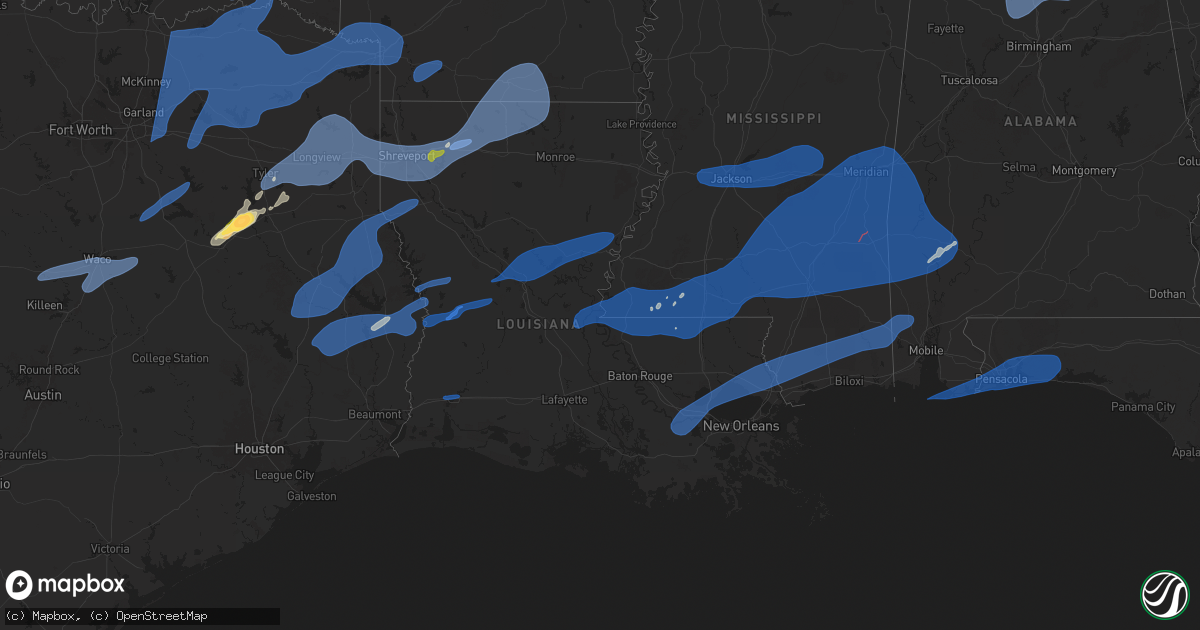
Hail Map in Louisiana on March 4, 2025
Get this storm
March 4 map
$229
one time, instant access
Download today. No call, no setup
Keep the $229
Bought the map and want the full workflow? Apply the entire $229 to a subscription within 7 days. None of it is wasted.
Every map, not just this one
This buys you this map. Subscription and you get every map we run, in the markets you choose from a few cities to whole states to nationwide. Plus real-time alerts the moment a storm fires.
Contact data
Name, contact info, occupancy, even credit band for addresses in the footprint. You go from where it hit to who to call.
Become the source they trust
Unlimited branding weather history reports on demand. You already have the documented answer ready for the property owner, and you are the one who showed up with it.
Property data and RoofTrace estimates
Pull up any address you have got, its value and the exact code rules for that jurisdiction, straight from One Click Code. Then RoofTrace estimates the squares, pitch, and roof value, priced the way you price.
Storm reports in Louisiana
Louisiana
| Date | Description |
|---|---|
| 03/04/20255:59 PM CST | Tree down causing additional damage to power pole near intersection of foy and dupard. |
| 03/04/20255:15 PM CST | Dam |
| 03/04/20255:15 PM CST | Roof and tree damage on n nobile st in paulina. |
| 03/04/20255:15 PM CST | Damage around the 1100 block of north airline ave in gramercy with continued damage to the east as well. |
| 03/04/20254:52 PM CST | Roof damage along river rd/hwy 942 in darrow. |
| 03/04/20254:25 PM CST | Multiple powerlines were downed by thunderstorm winds west of kentwood. |
| 03/04/20252:42 PM CST | Report from mping: 1-inch tree limbs broken; shingles blown off. |
| 03/04/20252:35 PM CST | West feliciana emergency management reported multiple trees down on along highway 10 northeast of st. Francisville. |
| 03/04/20252:27 PM CST | West feliciana emergency management reported multiple trees down on highway 421 east of highway 61. |
| 03/04/20251:00 PM CST | At the jonesville mesonet station. |
| 03/04/202512:55 PM CST | Near lana ln and hwy 3165... Trees down and a farm shed damaged. |
| 03/04/202512:45 PM CST | Roof blown off a building downtown. |
| 03/04/202512:28 PM CST | Couple trees down. |
| 03/04/202512:28 PM CST | Pictures of several trees blown down from cenlaweather. |
| 03/04/202512:28 PM CST | Gutters blown down and a 5 inch diameter tree snapped at that location. From cenlaweather meteorologist. |
| 03/04/202512:27 PM CST | Report from mping: 1-inch tree limbs broken; shingles blown off. |
| 03/04/202512:10 PM CST | A large tree was downed across highway 117 near the intersection of highway 478 in the vowells mill community. |
| 03/04/202512:06 PM CST | A tree was downed across miller road. |
| 03/04/202511:58 AM CST | A tree was downed across highway 139. |
| 03/04/202511:52 AM CST | Reports of damage in the boyce area. This may have been a tornado and will be surveyed tomorrow. |
| 03/04/202511:52 AM CST | The boyce tornado began between hwy 49 and hwy 1 in rapides parish... Where it downed several power lines. From there it continued northeast where it damaged homes as i |
| 03/04/202511:27 AM CST | Awos station kpoe fort polk fr. |
| 03/04/202511:24 AM CST | A tree was downed onto a power line across william basco road near the derry community. |
| 03/04/202511:24 AM CST | Utility lines were downed across highway 119 near longleaf vista road. |
| 03/04/202511:24 AM CST | Report from mping: 1-inch tree limbs broken; shingles blown off. |
| 03/04/202511:22 AM CST | Overturn trailer reported on base. 70 mph reported at the airfield at the time. |
| 03/04/202511:20 AM CST | Powerlines down. |
| 03/04/202511:12 AM CST | Multiple trees down on homes on mary street just north of natchitoches. |
| 03/04/202511:10 AM CST | Report from mping: 3-inch tree limbs broken; power poles broken. |
| 03/04/202511:05 AM CST | Large tree on train tracks in anacoco area. |
| 03/04/202511:02 AM CST | Photos received via social media showing an area of trees damaged. Several trees and power poles are snapped off 10 to 20 feet off of the ground. Possible tornado. Loca |
| 03/04/202510:59 AM CST | Picture of limbs down. One landed on a vehicle. |
| 03/04/202510:40 AM CST | Trees down with one fallen over highway 3121. |
| 03/04/202510:00 AM CST | Reports of multiple trees down around the intersection of hwy 80 and hwy 532. |
| 03/04/20259:27 AM CST | Straight-line winds estimated at 85 mph uplifted most of the roof of an outbuilding. |
| 03/04/20259:24 AM CST | Social media report of trees down near the shreveport hilton on n spring st. |
| 03/04/20259:24 AM CST | Light post blown down at car dealership in north bossier city. |
| 03/04/20259:24 AM CST | Light post blown down at car dealership in north bossier city. |
| 03/04/20259:22 AM CST | Measured at wfo shv by asos. |
| 03/04/20259:19 AM CST | This brief ef1 tornado touched down in the north highlands neighborhood of north shreveport. It initially began along booth drive and move east snapping the trunks of a |
| 03/04/20259:00 AM CST | This ef1 tornado began just east of the texas/louisiana state line in caddo parish and generally moved east along blanchard furrh road. Most of the damage consisted of |
| 03/03/20257:31 PM CST | Power poles down in the 26100 block of hwy 23 near port sulphur. |
| 03/03/20257:28 PM CST | Power pole damage near the courthouse in pointe a la hache. |
| 03/03/20256:38 PM CST | Large tree branches down on oak grove way in slidell. |
| 03/03/20256:09 PM CST | Wind gusts near mandeville estimated between 60 and 70 mph. |
| 03/03/20256:05 PM CST | Weatherflow mandeville observation recorded a 58 mph wind gust. |
All States Impacted by Hail Map on March 4, 2025
Cities Impacted by Hail Map on March 4, 2025
- Weleetka, OK
- Lamar, OK
- Wetumka, OK
- Dustin, OK
- Holdenville, OK
- Mcalester, OK
- Stuart, OK
- Kiowa, OK
- Wardville, OK
- Eufaula, OK
- Hanna, OK
- Indianola, OK
- Krebs, OK
- Savanna, OK
- Blanco, OK
- Caney, OK
- Atoka, OK
- Columbia, MO
- Auxvasse, MO
- Clearwater, NE
- Crowder, OK
- Canadian, OK
- Henryetta, OK
- Checotah, OK
- Council Hill, OK
- Boynton, OK
- Oktaha, OK
- Coalgate, OK
- Calvin, OK
- Pittsburg, OK
- Seagoville, TX
- Leonard, TX
- Ravenna, TX
- Forney, TX
- Trenton, TX
- Whitewright, TX
- Bonham, TX
- Celeste, TX
- Savoy, TX
- Randolph, TX
- Royse City, TX
- Blue Ridge, TX
- Nevada, TX
- Ector, TX
- Crandall, TX
- Rockwall, TX
- Farmersville, TX
- Lavon, TX
- Caddo Mills, TX
- Terrell, TX
- Greenville, TX
- Bailey, TX
- Wolfe City, TX
- Windom, TX
- Cooper, TX
- Brashear, TX
- Campbell, TX
- Klondike, TX
- Ladonia, TX
- Dodd City, TX
- Cumby, TX
- Sulphur Springs, TX
- Pecan Gap, TX
- Commerce, TX
- Honey Grove, TX
- Dike, TX
- Enloe, TX
- Roxton, TX
- Paris, TX
- Ben Franklin, TX
- Telephone, TX
- Petty, TX
- Sumner, TX
- Brookston, TX
- Lake Creek, TX
- Lone Oak, TX
- Point, TX
- Wills Point, TX
- Quinlan, TX
- Emory, TX
- Yantis, TX
- Mineola, TX
- Alba, TX
- Quitman, TX
- Como, TX
- Winnsboro, TX
- Pickton, TX
- Blossom, TX
- Pattonville, TX
- Sulphur Bluff, TX
- Saltillo, TX
- Deport, TX
- Muskogee, OK
- Haskell, OK
- Braggs, OK
- Warner, OK
- Hugo, OK
- Fort Gibson, OK
- Wagoner, OK
- Porter, OK
- Taft, OK
- Oakwood, TX
- Palestine, TX
- Tennessee Colony, TX
- Haileyville, OK
- Hartshorne, OK
- Wilburton, OK
- Red Oak, OK
- Overbrook, OK
- Roff, OK
- Tupelo, OK
- Centrahoma, OK
- Fittstown, OK
- Stonewall, OK
- Ada, OK
- Mannsville, OK
- Davis, OK
- Marietta, OK
- Wapanucka, OK
- Konawa, OK
- Sulphur, OK
- Lone Grove, OK
- Dougherty, OK
- Allen, OK
- Tishomingo, OK
- Springer, OK
- Atwood, OK
- Sasakwa, OK
- Ardmore, OK
- Fitzhugh, OK
- Milburn, OK
- Mill Creek, OK
- Hinton, OK
- Butler, OK
- Sharon, OK
- Hennessey, OK
- Hitchcock, OK
- Dill City, OK
- Thomas, OK
- Arapaho, OK
- Chester, OK
- Anadarko, OK
- Foss, OK
- Eldorado, OK
- Rocky, OK
- Colony, OK
- Greenfield, OK
- Hydro, OK
- Vici, OK
- Mooreland, OK
- Clinton, OK
- Cordell, OK
- Hollis, OK
- Custer City, OK
- Childress, TX
- Canute, OK
- Okarche, OK
- Binger, OK
- Olustee, OK
- Carter, OK
- Drummond, OK
- Camargo, OK
- Quanah, TX
- Calumet, OK
- Canton, OK
- Sayre, OK
- Gracemont, OK
- Hobart, OK
- Watonga, OK
- Geary, OK
- Ames, OK
- Oakwood, OK
- Fairview, OK
- Kingfisher, OK
- Gould, OK
- Lookeba, OK
- Mountain Park, OK
- Carnegie, OK
- Duke, OK
- Bison, OK
- Mangum, OK
- Blair, OK
- Roosevelt, OK
- Lawton, OK
- Omega, OK
- Granite, OK
- Leedey, OK
- Loyal, OK
- Taloga, OK
- Mountain View, OK
- Willow, OK
- Sentinel, OK
- Putnam, OK
- Southard, OK
- Hammon, OK
- Elk City, OK
- Lone Wolf, OK
- Mutual, OK
- Headrick, OK
- Bessie, OK
- Fort Cobb, OK
- Waukomis, OK
- Corn, OK
- Weatherford, OK
- Minco, OK
- Okeene, OK
- Dover, OK
- Longdale, OK
- Seiling, OK
- Gotebo, OK
- El Reno, OK
- Altus, OK
- Fay, OK
- Kemp, TX
- Frankston, TX
- Tyler, TX
- Bullard, TX
- Flint, TX
- Jacksonville, TX
- Hulbert, OK
- Whitehouse, TX
- Talco, TX
- Winfield, TX
- Detroit, TX
- Leesburg, TX
- Mount Pleasant, TX
- Pittsburg, TX
- Scroggins, TX
- Mount Vernon, TX
- Bogata, TX
- Clarksville, TX
- Overton, TX
- Winona, TX
- Kilgore, TX
- Arp, TX
- Longview, TX
- White Oak, TX
- Gladewater, TX
- Hallsville, TX
- Harleton, TX
- Gilmer, TX
- Diana, TX
- Ore City, TX
- Troup, TX
- Lone Star, TX
- Avinger, TX
- Jefferson, TX
- Henderson, TX
- Tatum, TX
- Marshall, TX
- Karnack, TX
- Beckville, TX
- Waskom, TX
- Shreveport, LA
- Mooringsport, LA
- Diboll, TX
- Lufkin, TX
- Apple Springs, TX
- Corrigan, TX
- Groveton, TX
- Huntington, TX
- Greenwood, LA
- Bethany, LA
- Keithville, LA
- Blanchard, LA
- De Berry, TX
- Bossier City, LA
- Haughton, LA
- Barksdale Afb, LA
- Stonewall, LA
- Frierson, LA
- Etoile, TX
- Nacogdoches, TX
- Chireno, TX
- Timpson, TX
- Center, TX
- Tenaha, TX
- San Augustine, TX
- Zavalla, TX
- Livingston, TX
- Chester, TX
- Moscow, TX
- Woodville, TX
- Elm Grove, LA
- Princeton, LA
- Minden, LA
- Joaquin, TX
- Colmesneil, TX
- Shelbyville, TX
- Logansport, LA
- Broaddus, TX
- Doyline, LA
- Warren, TX
- Ringgold, LA
- Bronson, TX
- Grand Cane, LA
- Mansfield, LA
- Sibley, LA
- Heflin, LA
- Dubberly, LA
- Gibsland, LA
- Athens, LA
- Homer, LA
- Jasper, TX
- Arcadia, LA
- Princeton, TX
- Mesquite, TX
- Newton, TX
- Wiergate, TX
- Dubach, LA
- Bernice, LA
- Lillie, LA
- Spearsville, LA
- Farmerville, LA
- Marion, LA
- Florien, LA
- Anacoco, LA
- Hornbeck, LA
- Deridder, LA
- Evans, LA
- Leesville, LA
- Fort Polk, LA
- Pitkin, LA
- Boyce, LA
- Colfax, LA
- Dry Prong, LA
- Sulphur, LA
- Lake Charles, LA
- Westlake, LA
- Kaufman, TX
- Simmesport, LA
- Moreauville, LA
- Plaucheville, LA
- Lettsworth, LA
- Woodville, MS
- Monterey, LA
- Batchelor, LA
- Angola, LA
- Saint Francisville, LA
- Gloster, MS
- Centreville, MS
- Waco, TX
- Woodway, TX
- McGregor, TX
- Oglesby, TX
- Crawford, TX
- Gatesville, TX
- Hewitt, TX
- Lorena, TX
- Moody, TX
- Chilton, TX
- Marlin, TX
- Riesel, TX
- Groesbeck, TX
- Mart, TX
- Bruceville, TX
- Eddy, TX
- Troy, TX
- Crosby, MS
- Norwood, LA
- Purdon, TX
- Dawson, TX
- Corsicana, TX
- Powell, TX
- Kerens, TX
- Liberty, MS
- Trinidad, TX
- Mabank, TX
- Jackson, LA
- Wilson, LA
- Clinton, LA
- Hemphill, TX
- Magnolia, MS
- Smithdale, MS
- Mccomb, MS
- Summit, MS
- Lisbon, LA
- Haynesville, LA
- Junction City, AR
- Summerfield, LA
- El Dorado, AR
- Hampton, AR
- Calion, AR
- Strong, AR
- Jersey, AR
- Huttig, AR
- Edwards, MS
- Bolton, MS
- Raymond, MS
- Jackson, MS
- Byram, MS
- Richland, MS
- Flowood, MS
- Clinton, MS
- Pearl, MS
- Tougaloo, MS
- Brandon, MS
- Ridgeland, MS
- Ethel, LA
- Greensburg, LA
- Kentwood, LA
- Osyka, MS
- Bogue Chitto, MS
- Mount Hermon, LA
- Lena, LA
- Pelahatchie, MS
- Morton, MS
- Lena, MS
- Pineville, LA
- Forest, MS
- Pulaski, MS
- Conehatta, MS
- Walnut Grove, MS
- Bentley, LA
- Pollock, LA
- Trout, LA
- Jena, LA
- Ball, LA
- Alexandria, LA
- Deville, LA
- Jonesville, LA
- Sicily Island, LA
- Harrisonburg, LA
- Lake, MS
- Hineston, LA
- Tylertown, MS
- Jayess, MS
- Ruth, MS
- Sieper, LA
- Ferriday, LA
- Clayton, LA
- Newton, MS
- Decatur, MS
- Lawrence, MS
- Union, MS
- Sebastopol, MS
- Philadelphia, MS
- Franklinton, LA
- Monticello, MS
- Kokomo, MS
- Foxworth, MS
- Brookhaven, MS
- Oak Vale, MS
- Silver Creek, MS
- Fluker, LA
- Amite, LA
- Columbia, MS
- Prentiss, MS
- Magee, MS
- Collins, MS
- Mount Olive, MS
- Carson, MS
- Newhebron, MS
- Mendenhall, MS
- Raleigh, MS
- Pinola, MS
- Mize, MS
- Bassfield, MS
- Seminary, MS
- Sumrall, MS
- Lumberton, MS
- Taylorsville, MS
- Soso, MS
- Purvis, MS
- Petal, MS
- Hattiesburg, MS
- Moselle, MS
- Ellisville, MS
- Bay Springs, MS
- Little Rock, MS
- Enterprise, MS
- Heidelberg, MS
- Laurel, MS
- Collinsville, MS
- Chunky, MS
- Stringer, MS
- Paulding, MS
- Meridian, MS
- Louin, MS
- Vossburg, MS
- Hickory, MS
- Rose Hill, MS
- Waynesboro, MS
- Pachuta, MS
- Ovett, MS
- Shubuta, MS
- Daleville, MS
- Quitman, MS
- Richton, MS
- Toomsuba, MS
- Bailey, MS
- Marion, MS
- Lauderdale, MS
- Stonewall, MS
- Thibodaux, LA
- Vacherie, LA
- Gramercy, LA
- Paulina, LA
- Convent, LA
- Saint James, LA
- Garyville, LA
- Lutcher, LA
- Reserve, LA
- La Place, LA
- Mount Airy, LA
- Edgard, LA
- Hahnville, LA
- Covington, LA
- Ponchatoula, LA
- Madisonville, LA
- Mandeville, LA
- Lacombe, LA
- Poplarville, MS
- Kiln, MS
- Gulfport, MS
- Lucedale, MS
- Pearl River, LA
- Vancleave, MS
- Picayune, MS
- Saucier, MS
- Stennis Space Center, MS
- Carriere, MS
- Pass Christian, MS
- Slidell, LA
- McHenry, MS
- Perkinston, MS
- Abita Springs, LA
- Bay Saint Louis, MS
- Biloxi, MS
- Bush, LA
- Wilmer, AL
- Citronelle, AL
- New Augusta, MS
- Toxey, AL
- Butler, AL
- Melvin, AL
- Silas, AL
- Cuba, AL
- Lisman, AL
- Porterville, MS
- York, AL
- Needham, AL
- Gilbertown, AL
- Jachin, AL
- Ward, AL
- State Line, MS
- Leakesville, MS
- Buckatunna, MS
- Deer Park, AL
- Beaumont, MS
- Coffeeville, AL
- Leroy, AL
- Jackson, AL
- Fruitdale, AL
- Wagarville, AL
- Chatom, AL
- Saint Stephens, AL
- Campbell, AL
- Thomasville, AL
- Frankville, AL
- Tibbie, AL
- Millry, AL
- Chunchula, AL
- Sweet Water, AL
- Whatley, AL
- Grove Hill, AL
- Dickinson, AL
- Vinegar Bend, AL
- Neely, MS
- Arley, AL
- Vinemont, AL
- Addison, AL
- Crane Hill, AL
- Logan, AL
- Cullman, AL
- Cordova, AL
- Bremen, AL
- Jasper, AL
- Empire, AL
- Hanceville, AL
- Dora, AL
- Hayden, AL
- Sumiton, AL
- Warrior, AL
- Oneonta, AL
- Cleveland, AL
- Blountsville, AL
- Danville, AL
- Tanner, AL
- Joppa, AL
- Falkville, AL
- Valhermoso Springs, AL
- Somerville, AL
- Holly Pond, AL
- Laceys Spring, AL
- Huntsville, AL
- Eva, AL
- Madison, AL
- Baileyton, AL
- Decatur, AL
- Hartselle, AL
- Arab, AL
- Union Grove, AL
- Owens Cross Roads, AL
- Grant, AL
- Altoona, AL
- New Hope, AL
- Albertville, AL
- Horton, AL
- Boaz, AL
- Guntersville, AL
- Brownsboro, AL
- Groveoak, AL
- Crossville, AL
- Geraldine, AL
- Monticello, FL
- Fort Walton Beach, FL
- Navarre, FL
- Gulf Breeze, FL
- Mary Esther, FL
- Pensacola, FL
- Lillian, AL
- Orange Beach, AL
- Seminole, AL
- Elberta, AL
- Eglin Afb, FL
- Milton, FL
- Bagdad, FL
- Hurlburt Field, FL
- Shalimar, FL
- Bon Secour, AL
- Foley, AL
- Gulf Shores, AL
- Burkeville, TX
- Arthur City, TX
- Powderly, TX
- Grant, OK
- Fort Towson, OK
- Sawyer, OK
- Woodville, AL
- Paint Rock, AL
- Gurley, AL
- Langston, AL
- Scottsboro, AL
- De Kalb, TX
- Cookville, TX
- Avery, TX
- Annona, TX
- Naples, TX
- Simms, TX
- Omaha, TX
- New Boston, TX
- Foreman, AR
- Texarkana, TX
- Hooks, TX
- Maud, TX
- Fyffe, AL
- Section, AL
- Ashdown, AR
- Fouke, AR
- Nash, TX
- Texarkana, AR
- Dutton, AL
- Hollywood, AL
- Sylvania, AL
- Henagar, AL
- Dawson, AL
- Rainsville, AL
- Pisgah, AL
- Fulton, AR
- Ogden, AR
- Flat Rock, AL
- Fort Payne, AL
- Stevenson, AL
- Valley Head, AL
- Ider, AL
- Bryant, AL
- Higdon, AL
- Trenton, GA
- Rising Fawn, GA
- Lewisville, AR
- Taylor, AR
- Buckner, AR
- Stamps, AR
- Waldo, AR
- Chickamauga, GA
- Flintstone, GA
- Rossville, GA
- Wildwood, GA
- Lookout Mountain, GA
- La Fayette, GA
- Rock Spring, GA
- Ooltewah, TN
- Chattanooga, TN
- Fort Oglethorpe, GA
- Cleveland, TN
- McDonald, TN
- Ringgold, GA
- Apison, TN
- Cohutta, GA
- Tunnel Hill, GA
- Dalton, GA
- Old Fort, TN
- Rusk, TX
- Okmulgee, OK
- Morris, OK


