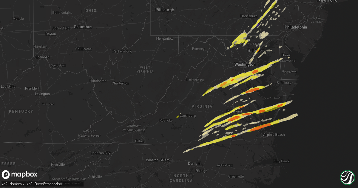
Hail Map in Virginia on February 25, 2017
Get this storm
February 25 map
$229
one time, instant access
Download today. No call, no setup
Keep the $229
Bought the map and want the full workflow? Apply the entire $229 to a subscription within 7 days. None of it is wasted.
Every map, not just this one
This buys you this map. Subscription and you get every map we run, in the markets you choose from a few cities to whole states to nationwide. Plus real-time alerts the moment a storm fires.
Contact data
Name, contact info, occupancy, even credit band for addresses in the footprint. You go from where it hit to who to call.
Become the source they trust
Unlimited branding weather history reports on demand. You already have the documented answer ready for the property owner, and you are the one who showed up with it.
Property data and RoofTrace estimates
Pull up any address you have got, its value and the exact code rules for that jurisdiction, straight from One Click Code. Then RoofTrace estimates the squares, pitch, and roof value, priced the way you price.
Storm reports in Virginia
Virginia
| Date | Description |
|---|---|
| 02/25/20175:11 PM CST | . |
| 02/25/20175:09 PM CST | At christopher newport college |
| 02/25/20175:01 PM CST | A local report indicates 1.00 inch wind near LANGLEY AFB |
| 02/25/20175:00 PM CST | Quarter to golfball size coverning the ground. |
| 02/25/20175:00 PM CST | Quarter to golfball size coverning the ground at hampton holiday park. |
| 02/25/20174:59 PM CST | . |
| 02/25/20174:58 PM CST | A local report indicates 1.50 inch wind near HAMPTON |
| 02/25/20174:54 PM CST | . |
| 02/25/20174:49 PM CST | Hail is covering the ground and roads. |
| 02/25/20174:48 PM CST | . |
| 02/25/20174:45 PM CST | Hail covering the ground. |
| 02/25/20174:29 PM CST | . The duration of the hail event was 5 minutes. |
| 02/25/20173:15 PM CST | . The duration of the hail event was 10 minutes. |
| 02/25/20173:10 PM CST | A local report indicates 1.00 inch wind near PROVIDENCE FORGE |
| 02/25/20173:10 PM CST | A local report indicates 1.00 inch wind near 2 NNW JORDAN POINT COUN |
| 02/25/20173:06 PM CST | A local report indicates 1.00 inch wind near 3 NW BOWENS CORNER |
| 02/25/20173:00 PM CST | A local report indicates 1.00 inch wind near COLONIAL HEIGHTS |
| 02/25/20172:48 PM CST | Picture from social media. Time estimated from radar. |
| 02/25/20172:46 PM CST | Large diameter tree knocked down into a house. |
| 02/25/20172:46 PM CST | A local report indicates 1.75 inch wind near 3 SW MEADOWVILLE |
| 02/25/20172:45 PM CST | Time estimated by radar. |
| 02/25/20172:36 PM CST | Hail covering the ground. |
| 02/25/20172:35 PM CST | Report from mping. |
| 02/25/20172:28 PM CST | A local report indicates 1.00 inch wind near 3 ESE WINTERPOCK |
| 02/25/20172:27 PM CST | Hail covering the ground. Estimated 50-60 mph wind gust. Time estimated from radar. |
| 02/25/20172:21 PM CST | Time estimated from radar. |
| 02/25/20172:16 PM CST | A local report indicates 1.00 inch wind near 2 WSW MECHANICSVILLE |
| 02/25/20172:12 PM CST | Roof damage. |
| 02/25/20172:08 PM CST | Quarter size hail |
| 02/25/20171:53 PM CST | Time estimated from radar. |
| 02/25/20171:48 PM CST | Quarter sized hail |
| 02/25/20171:47 PM CST | A local report indicates 58 MPH wind near 1 SW QUANTICO |
| 02/25/20171:42 PM CST | Quarter sized hail |
| 02/25/20171:40 PM CST | A local report indicates 1.00 inch wind near AQUIA |
| 02/25/20171:39 PM CST | Hail covering the ground. Time estimated from radar. |
| 02/25/20171:37 PM CST | Quarter size hail at intersection of va rt 610 and i-95 |
| 02/25/20171:36 PM CST | Quarter size hail |
| 02/25/20171:32 PM CST | Quarter sized hail |
| 02/25/20171:29 PM CST | At courthouse rd. |
| 02/25/20171:21 PM CST | Tree limb on power lines on east market street near church street. |
| 02/25/20171:16 PM CST | A local report indicates 1.00 inch wind near 3 W LOGAN |
| 02/25/20171:10 PM CST | Time estimated from radar. |
| 02/25/20171:05 PM CST | Time estimated by radar. |
| 02/25/201712:51 PM CST | Large tree down near orange county landfill |
| 02/25/201712:24 PM CST | Multiple trees down and dime size hail |
| 02/25/201712:22 PM CST | Tree down at 1500 block of dairy rd |
| 02/25/201712:06 PM CST | Tree down onto power lines at 4734 cowan rd |
| 02/25/201711:54 AM CST | Electric company reported one tree down on a power line along little piney road |
| 02/25/201711:52 AM CST | Large tree limbs down on indian valley road |
| 02/25/201711:40 AM CST | Wind split part of tree in lynchburg which caused damage to a chain link fence. |
All States Impacted by Hail Map on February 25, 2017
Cities Impacted by Hail Map on February 25, 2017
- Onancock, VA
- Greenbush, VA
- Onley, VA
- Accomac, VA
- Parksley, VA
- Hopewell, VA
- Baltimore, MD
- Rosedale, MD
- Linthicum Heights, MD
- Brooklyn, MD
- Glen Burnie, MD
- Curtis Bay, MD
- Halethorpe, MD
- White Haven, PA
- Lake Harmony, PA
- Blakeslee, PA
- Tappahannock, VA
- Milford, VA
- Valley Lee, MD
- Drayden, MD
- Hague, VA
- Callaway, MD
- Tall Timbers, MD
- Warsaw, VA
- Bowling Green, VA
- Ruther Glen, VA
- Hustle, VA
- Champlain, VA
- Bumpass, VA
- Colonial Beach, VA
- Loretto, VA
- Montpelier, VA
- Coltons Point, MD
- Leonardtown, MD
- Beaverdam, VA
- Montross, VA
- Great Mills, MD
- Doswell, VA
- Maidens, VA
- Park Hall, MD
- Caret, VA
- California, MD
- Patuxent River, MD
- Lexington Park, MD
- Fishing Creek, MD
- Fredericksburg, VA
- Petersburg, VA
- Disputanta, VA
- Charles City, VA
- King William, VA
- Walkerton, VA
- Frederick, MD
- Middletown, DE
- Townsend, DE
- Shartlesville, PA
- Bernville, PA
- Richland, PA
- Myerstown, PA
- Hamburg, PA
- Newmanstown, PA
- Womelsdorf, PA
- Lebanon, PA
- Chesterfield, VA
- Colonial Heights, VA
- Richmond, VA
- Henrico, VA
- Chester, VA
- Amelia Court House, VA
- Church Road, VA
- Blackstone, VA
- Barhamsville, VA
- West Point, VA
- Keysville, VA
- Meherrin, VA
- Poquoson, VA
- Smithfield, VA
- Elberon, VA
- Hampton, VA
- Ivor, VA
- Yorktown, VA
- Wakefield, VA
- Newport News, VA
- Cape Charles, VA
- Westminster, MD
- New Windsor, MD
- Brandywine, MD
- Walton, NY
- Downsville, NY
- Glen Arm, MD
- Fork, MD
- Hydes, MD
- Fallston, MD
- Kingsville, MD
- Baldwin, MD
- Big Island, VA
- Goode, VA
- Goldsboro, MD
- Felton, DE
- Camden Wyoming, DE
- East Berlin, PA
- Dover, PA
- Thomasville, PA
- Jarratt, VA
- King George, VA
- Rhoadesville, VA
- Shady Side, MD
- Mcdaniel, MD
- North Beach, MD
- Owings, MD
- Woodbridge, VA
- Saint Michaels, MD
- Stafford, VA
- Churchton, MD
- Richardsville, VA
- Midland, VA
- Culpeper, VA
- Waldorf, MD
- Charlottesville, VA
- Queenstown, MD
- Cordova, MD
- Burr Hill, VA
- Barboursville, VA
- Quantico, VA
- Claiborne, MD
- Spotsylvania, VA
- Nanjemoy, MD
- North Garden, VA
- Rapidan, VA
- Deale, MD
- Goldvein, VA
- White Plains, MD
- Keswick, VA
- Easton, MD
- Wittman, MD
- La Plata, MD
- Wye Mills, MD
- Accokeek, MD
- Bryans Road, MD
- Triangle, VA
- Welcome, MD
- Huntingtown, MD
- Chesapeake Beach, MD
- Gordonsville, VA
- Stevensville, MD
- Centreville, MD
- Tracys Landing, MD
- Sherwood, MD
- Pomfret, MD
- Henderson, MD
- Lorton, VA
- Port Tobacco, MD
- Marbury, MD
- Locust Grove, VA
- Sumerduck, VA
- Orange, VA
- Upper Marlboro, MD
- Sunderland, MD
- Queen Anne, MD
- Bozman, MD
- Dumfries, VA
- Ridgely, MD
- Indian Head, MD
- Aquasco, MD
- Lignum, VA
- Friendship, MD
- Greensboro, MD
- Dunkirk, MD
- Unionville, VA
- Somerset, VA
- Ijamsville, MD
- La Crosse, VA
- Port Clinton, PA
- Orwigsburg, PA
- Williamsburg, VA
- Charles Town, WV
- Kenbridge, VA
- Dundas, VA
- Farnham, VA
- Center Cross, VA
- Dunnsville, VA
- Starlight, PA
- Hancock, NY
- Fishs Eddy, NY
- Equinunk, PA
- East Branch, NY
- Long Eddy, NY
- Weatherly, PA
- Beaver Meadows, PA
- Nesquehoning, PA
- Freeland, PA
- Tamaqua, PA
- Yale, VA
- Stony Creek, VA
- McKenney, VA
- Charlotte Hall, MD
- Prince Frederick, MD
- Benedict, MD
- Mechanicsville, MD
- Hughesville, MD
- Ford, VA
- Topping, VA
- Melfa, VA
- Shacklefords, VA
- Saluda, VA
- New Kent, VA
- Burkeville, VA
- Locust Hill, VA
- Toano, VA
- Drakes Branch, VA
- North, VA
- Mattaponi, VA
- Wilsons, VA
- Gloucester, VA
- Saxe, VA
- White Stone, VA
- Deltaville, VA
- Hartfield, VA
- Crewe, VA
- Lanexa, VA
- Victoria, VA
- Prince George, VA
- Cobbs Creek, VA
- Bloxom, VA
- Wake, VA
- Hardyville, VA
- Dutton, VA
- Green Bay, VA
- Sutherland, VA
- Providence Forge, VA
- Painter, VA
- Keymar, MD
- Woodsboro, MD
- Union Bridge, MD
- Odenton, MD
- Conowingo, MD
- Darlington, MD
- Whiteford, MD
- Pylesville, MD
- Fawn Grove, PA
- Peach Bottom, PA
- Airville, PA
- Street, MD
- Drumore, PA
- Jarrettsville, MD
- Delta, PA
- Frederica, DE
- Magnolia, DE
- Dover, DE
- Littlestown, PA
- Lakewood, PA
- Pleasant Mount, PA
- Laurel, MD
- Bowie, MD
- Middletown, MD
- Braddock Heights, MD
- Jefferson, MD
- Hazleton, PA
- Drums, PA
- Red Oak, VA
- Skipwith, VA
- Dewitt, VA
- Dinwiddie, VA
- Lancaster, PA
- Washington Boro, PA
- Millersville, PA
- Bryantown, MD
- Newburg, MD
- Port Republic, MD
- Bel Alton, MD
- Faulkner, MD
- Rice, VA
- Moseley, VA
- Jetersville, VA
- Macungie, PA
- Boyertown, PA
- Bechtelsville, PA
- Emmaus, PA
- Barto, PA
- Zionsville, PA
- Auburn, PA
- Kempton, PA
- Manheim, PA
- Lititz, PA
- New Ringgold, PA
- Mohrsville, PA
- Schaefferstown, PA
- Robesonia, PA
- Aberdeen Proving Ground, MD
- Gunpowder, MD
- Edgewood, MD
- Leasburg, NC
- Roxboro, NC
- Midlothian, VA
- Pasadena, MD
- Felton, PA
- Stewartstown, PA
- Sandston, VA
- Emmitsburg, MD
- Taneytown, MD
- Crapo, MD
- Marietta, PA
- Maytown, PA
- Mount Joy, PA
- Knoxville, MD
- Bird In Hand, PA
- Willow Street, PA
- Leola, PA
- Worton, MD
- Chestertown, MD
- Pittston, PA
- Wilkes Barre, PA
- Mechanicsville, VA
- Surry, VA
- Spring Grove, VA
- Bruington, VA
- Wylliesburg, VA
- Chase City, VA
- Saint Stephens Church, VA
- Aylett, VA
- Thurmont, MD
- Hanover, PA
- Rocky Ridge, MD
- Gettysburg, PA
- Walkersville, MD
- Upperville, VA
- Mountain Top, PA
- Hampstead, MD
- Manchester, MD
- Duryea, PA
- Moosic, PA
- Scranton, PA
- Moscow, PA
- Taylor, PA
- Peckville, PA
- Old Forge, PA
- Olyphant, PA
- Jermyn, PA
- Jessup, PA
- Wapwallopen, PA
- Archbald, PA
- Elizabethtown, PA
- York New Salem, PA
- Wrightsville, PA
- Seven Valleys, PA
- York, PA
- Columbia, PA
- Severna Park, MD
- Purcellville, VA
- Round Hill, VA
- Waverly, VA
- Ronks, PA
- Strasburg, PA
- Quarryville, PA
- Paradise, PA
- King And Queen Court House, VA
- Fort George G Meade, MD
- Lanham, MD
- Glenn Dale, MD
- Ephrata, PA
- Fleetwood, PA
- Mertztown, PA
- Sykesville, MD
- Newtown, VA
- Windsor, PA
- Landisville, PA
- Mountville, PA
- Red Lion, PA
- Freeman, VA
- Lawrenceville, VA
- Clarksville, VA
- Cumbola, PA
- Pine Grove, PA
- Pottsville, PA
- New Philadelphia, PA
- Cressona, PA
- Schuylkill Haven, PA
- Port Carbon, PA
- Emporia, VA
- Boydton, VA
- South Hill, VA
- Bullock, NC
- White Plains, VA
- Brodnax, VA
- Bracey, VA
- Oxford, NC
- Nelson, VA
- Buffalo Junction, VA
- Baskerville, VA
- Douglassville, PA
- Birdsboro, PA
- Kutztown, PA
- Lenhartsville, PA
- Ashland, VA
- Bethel, PA
- Barnesville, PA
- Middleport, PA
- Brockton, PA
- Hayes, VA
- Farmville, VA
- Finksburg, MD
- Hanover, MD
- Hyattsville, MD
- Bel Air, MD
- Harmans, MD
- Capitol Heights, MD
- Parkville, MD
- Perry Hall, MD
- Nottingham, MD
- Beltsville, MD
- Forest Hill, MD
- Greenbelt, MD
- Severn, MD
- Spring Grove, PA
- Myersville, MD
- Reading, PA
- Prompton, PA
- Denver, PA
- Reinholds, PA
- Mohnton, PA
- East Earl, PA
- New Holland, PA
- Terre Hill, PA
- Stevens, PA
- Kinzers, PA
- Andreas, PA
- McSherrystown, PA
- Glenville, PA
- New Oxford, PA
- Leesport, PA
- Powhatan, VA
- Brogue, PA
- Waymart, PA
- Lake Ariel, PA
- Forest City, PA
- Carbondale, PA
- Lovettsville, VA
- Manquin, VA
- Stevensville, VA
- Hanover, VA
- Lutherville Timonium, MD
- Towson, MD
- Mount Airy, MD
- Woodbine, MD
- Freeland, MD
- Gloucester Point, VA
- Randolph, VA
- Clover, VA
- Scottsburg, VA
- Alberta, VA
- Shoemakersville, PA
- Warfield, VA
- Dolphin, VA
- Windsor, VA
- Henderson, NC
- Courtland, VA
- Burlington, NC
- Yanceyville, NC
- Mebane, NC
- White Hall, MD
- Deposit, NY
- Gouldsboro, PA
- Honesdale, PA
- Sterling, PA
- Hawley, PA
- Virgilina, VA
- Narvon, PA
- Morgantown, PA
- Harleigh, PA
- Sheppton, PA
- Rodman, NY
- Churchville, MD
- New Park, PA
- Holtwood, PA
- Pocono Lake, PA
- Tobyhanna, PA
- Belle Haven, VA
- Hudgins, VA
- Hacksneck, VA
- Carson, VA
- Carrollton, VA
- Earlysville, VA
- Bedford, VA


