Hail Map in Stafford, VA on February 25, 2017
The weather event in Stafford, VA on February 25, 2017 includes Hail map. 7 states and 482 cities were impacted and suffered possible damage. The total estimated number of properties impacted is 19,221.
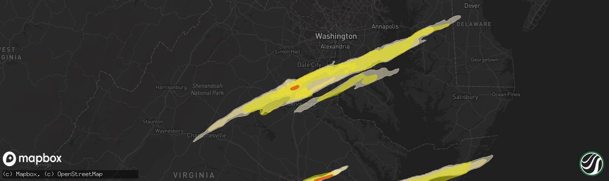
Hail
19,221
Estimated number of impacted properties by a 1.00" hail or larger2,073
Estimated number of impacted properties by a 1.75" hail or larger0
Estimated number of impacted properties by a 2.50" hail or largerStorm reports in Stafford, VA
Stafford, VA
| Date | Description |
|---|---|
| 02/25/20171:48 PM CST | Quarter sized hail |
| 02/25/20171:40 PM CST | A local report indicates 1.00 inch wind near AQUIA |
| 02/25/20171:37 PM CST | Quarter size hail at intersection of va rt 610 and i-95 |
| 02/25/20171:36 PM CST | Quarter size hail |
| 02/25/20171:29 PM CST | At courthouse rd. |
All States Impacted by Hail Map on February 25, 2017
All Cities Impacted by Hail Map on February 25, 2017
- Onancock, VA
- Greenbush, VA
- Onley, VA
- Accomac, VA
- Parksley, VA
- Hopewell, VA
- Baltimore, MD
- Rosedale, MD
- Linthicum Heights, MD
- Brooklyn, MD
- Glen Burnie, MD
- Curtis Bay, MD
- Halethorpe, MD
- White Haven, PA
- Lake Harmony, PA
- Blakeslee, PA
- Tappahannock, VA
- Milford, VA
- Valley Lee, MD
- Drayden, MD
- Hague, VA
- Callaway, MD
- Tall Timbers, MD
- Warsaw, VA
- Bowling Green, VA
- Ruther Glen, VA
- Hustle, VA
- Champlain, VA
- Bumpass, VA
- Colonial Beach, VA
- Loretto, VA
- Montpelier, VA
- Coltons Point, MD
- Leonardtown, MD
- Beaverdam, VA
- Montross, VA
- Great Mills, MD
- Doswell, VA
- Maidens, VA
- Park Hall, MD
- Caret, VA
- California, MD
- Patuxent River, MD
- Lexington Park, MD
- Fishing Creek, MD
- Fredericksburg, VA
- Petersburg, VA
- Disputanta, VA
- Charles City, VA
- King William, VA
- Walkerton, VA
- Frederick, MD
- Middletown, DE
- Townsend, DE
- Shartlesville, PA
- Bernville, PA
- Richland, PA
- Myerstown, PA
- Hamburg, PA
- Newmanstown, PA
- Womelsdorf, PA
- Lebanon, PA
- Chesterfield, VA
- Colonial Heights, VA
- Richmond, VA
- Henrico, VA
- Chester, VA
- Amelia Court House, VA
- Church Road, VA
- Blackstone, VA
- Barhamsville, VA
- West Point, VA
- Keysville, VA
- Meherrin, VA
- Poquoson, VA
- Smithfield, VA
- Elberon, VA
- Hampton, VA
- Ivor, VA
- Yorktown, VA
- Wakefield, VA
- Newport News, VA
- Cape Charles, VA
- Westminster, MD
- New Windsor, MD
- Brandywine, MD
- Walton, NY
- Downsville, NY
- Glen Arm, MD
- Fork, MD
- Hydes, MD
- Fallston, MD
- Kingsville, MD
- Baldwin, MD
- Big Island, VA
- Goode, VA
- Goldsboro, MD
- Felton, DE
- Camden Wyoming, DE
- East Berlin, PA
- Dover, PA
- Thomasville, PA
- Jarratt, VA
- King George, VA
- Rhoadesville, VA
- Shady Side, MD
- Mcdaniel, MD
- North Beach, MD
- Owings, MD
- Woodbridge, VA
- Saint Michaels, MD
- Stafford, VA
- Churchton, MD
- Richardsville, VA
- Midland, VA
- Culpeper, VA
- Waldorf, MD
- Charlottesville, VA
- Queenstown, MD
- Cordova, MD
- Burr Hill, VA
- Barboursville, VA
- Quantico, VA
- Claiborne, MD
- Spotsylvania, VA
- Nanjemoy, MD
- North Garden, VA
- Rapidan, VA
- Deale, MD
- Goldvein, VA
- White Plains, MD
- Keswick, VA
- Easton, MD
- Wittman, MD
- La Plata, MD
- Wye Mills, MD
- Accokeek, MD
- Bryans Road, MD
- Triangle, VA
- Welcome, MD
- Huntingtown, MD
- Chesapeake Beach, MD
- Gordonsville, VA
- Stevensville, MD
- Centreville, MD
- Tracys Landing, MD
- Sherwood, MD
- Pomfret, MD
- Henderson, MD
- Lorton, VA
- Port Tobacco, MD
- Marbury, MD
- Locust Grove, VA
- Sumerduck, VA
- Orange, VA
- Upper Marlboro, MD
- Sunderland, MD
- Queen Anne, MD
- Bozman, MD
- Dumfries, VA
- Ridgely, MD
- Indian Head, MD
- Aquasco, MD
- Lignum, VA
- Friendship, MD
- Greensboro, MD
- Dunkirk, MD
- Unionville, VA
- Somerset, VA
- Ijamsville, MD
- La Crosse, VA
- Port Clinton, PA
- Orwigsburg, PA
- Williamsburg, VA
- Charles Town, WV
- Kenbridge, VA
- Dundas, VA
- Farnham, VA
- Center Cross, VA
- Dunnsville, VA
- Starlight, PA
- Hancock, NY
- Fishs Eddy, NY
- Equinunk, PA
- East Branch, NY
- Long Eddy, NY
- Weatherly, PA
- Beaver Meadows, PA
- Nesquehoning, PA
- Freeland, PA
- Tamaqua, PA
- Yale, VA
- Stony Creek, VA
- McKenney, VA
- Charlotte Hall, MD
- Prince Frederick, MD
- Benedict, MD
- Mechanicsville, MD
- Hughesville, MD
- Ford, VA
- Topping, VA
- Melfa, VA
- Shacklefords, VA
- Saluda, VA
- New Kent, VA
- Burkeville, VA
- Locust Hill, VA
- Toano, VA
- Drakes Branch, VA
- North, VA
- Mattaponi, VA
- Wilsons, VA
- Gloucester, VA
- Saxe, VA
- White Stone, VA
- Deltaville, VA
- Hartfield, VA
- Crewe, VA
- Lanexa, VA
- Victoria, VA
- Prince George, VA
- Cobbs Creek, VA
- Bloxom, VA
- Wake, VA
- Hardyville, VA
- Dutton, VA
- Green Bay, VA
- Sutherland, VA
- Providence Forge, VA
- Painter, VA
- Keymar, MD
- Woodsboro, MD
- Union Bridge, MD
- Odenton, MD
- Conowingo, MD
- Darlington, MD
- Whiteford, MD
- Pylesville, MD
- Fawn Grove, PA
- Peach Bottom, PA
- Airville, PA
- Street, MD
- Drumore, PA
- Jarrettsville, MD
- Delta, PA
- Frederica, DE
- Magnolia, DE
- Dover, DE
- Littlestown, PA
- Lakewood, PA
- Pleasant Mount, PA
- Laurel, MD
- Bowie, MD
- Middletown, MD
- Braddock Heights, MD
- Jefferson, MD
- Hazleton, PA
- Drums, PA
- Red Oak, VA
- Skipwith, VA
- Dewitt, VA
- Dinwiddie, VA
- Lancaster, PA
- Washington Boro, PA
- Millersville, PA
- Bryantown, MD
- Newburg, MD
- Port Republic, MD
- Bel Alton, MD
- Faulkner, MD
- Rice, VA
- Moseley, VA
- Jetersville, VA
- Macungie, PA
- Boyertown, PA
- Bechtelsville, PA
- Emmaus, PA
- Barto, PA
- Zionsville, PA
- Auburn, PA
- Kempton, PA
- Manheim, PA
- Lititz, PA
- New Ringgold, PA
- Mohrsville, PA
- Schaefferstown, PA
- Robesonia, PA
- Aberdeen Proving Ground, MD
- Gunpowder, MD
- Edgewood, MD
- Leasburg, NC
- Roxboro, NC
- Midlothian, VA
- Pasadena, MD
- Felton, PA
- Stewartstown, PA
- Sandston, VA
- Emmitsburg, MD
- Taneytown, MD
- Crapo, MD
- Marietta, PA
- Maytown, PA
- Mount Joy, PA
- Knoxville, MD
- Bird In Hand, PA
- Willow Street, PA
- Leola, PA
- Worton, MD
- Chestertown, MD
- Pittston, PA
- Wilkes Barre, PA
- Mechanicsville, VA
- Surry, VA
- Spring Grove, VA
- Bruington, VA
- Wylliesburg, VA
- Chase City, VA
- Saint Stephens Church, VA
- Aylett, VA
- Thurmont, MD
- Hanover, PA
- Rocky Ridge, MD
- Gettysburg, PA
- Walkersville, MD
- Upperville, VA
- Mountain Top, PA
- Hampstead, MD
- Manchester, MD
- Duryea, PA
- Moosic, PA
- Scranton, PA
- Moscow, PA
- Taylor, PA
- Peckville, PA
- Old Forge, PA
- Olyphant, PA
- Jermyn, PA
- Jessup, PA
- Wapwallopen, PA
- Archbald, PA
- Elizabethtown, PA
- York New Salem, PA
- Wrightsville, PA
- Seven Valleys, PA
- York, PA
- Columbia, PA
- Severna Park, MD
- Purcellville, VA
- Round Hill, VA
- Waverly, VA
- Ronks, PA
- Strasburg, PA
- Quarryville, PA
- Paradise, PA
- King And Queen Court House, VA
- Fort George G Meade, MD
- Lanham, MD
- Glenn Dale, MD
- Ephrata, PA
- Fleetwood, PA
- Mertztown, PA
- Sykesville, MD
- Newtown, VA
- Windsor, PA
- Landisville, PA
- Mountville, PA
- Red Lion, PA
- Freeman, VA
- Lawrenceville, VA
- Clarksville, VA
- Cumbola, PA
- Pine Grove, PA
- Pottsville, PA
- New Philadelphia, PA
- Cressona, PA
- Schuylkill Haven, PA
- Port Carbon, PA
- Emporia, VA
- Boydton, VA
- South Hill, VA
- Bullock, NC
- White Plains, VA
- Brodnax, VA
- Bracey, VA
- Oxford, NC
- Nelson, VA
- Buffalo Junction, VA
- Baskerville, VA
- Douglassville, PA
- Birdsboro, PA
- Kutztown, PA
- Lenhartsville, PA
- Ashland, VA
- Bethel, PA
- Barnesville, PA
- Middleport, PA
- Brockton, PA
- Hayes, VA
- Farmville, VA
- Finksburg, MD
- Hanover, MD
- Hyattsville, MD
- Bel Air, MD
- Harmans, MD
- Capitol Heights, MD
- Parkville, MD
- Perry Hall, MD
- Nottingham, MD
- Beltsville, MD
- Forest Hill, MD
- Greenbelt, MD
- Severn, MD
- Spring Grove, PA
- Myersville, MD
- Reading, PA
- Prompton, PA
- Denver, PA
- Reinholds, PA
- Mohnton, PA
- East Earl, PA
- New Holland, PA
- Terre Hill, PA
- Stevens, PA
- Kinzers, PA
- Andreas, PA
- McSherrystown, PA
- Glenville, PA
- New Oxford, PA
- Leesport, PA
- Powhatan, VA
- Brogue, PA
- Waymart, PA
- Lake Ariel, PA
- Forest City, PA
- Carbondale, PA
- Lovettsville, VA
- Manquin, VA
- Stevensville, VA
- Hanover, VA
- Lutherville Timonium, MD
- Towson, MD
- Mount Airy, MD
- Woodbine, MD
- Freeland, MD
- Gloucester Point, VA
- Randolph, VA
- Clover, VA
- Scottsburg, VA
- Alberta, VA
- Shoemakersville, PA
- Warfield, VA
- Dolphin, VA
- Windsor, VA
- Henderson, NC
- Courtland, VA
- Burlington, NC
- Yanceyville, NC
- Mebane, NC
- White Hall, MD
- Deposit, NY
- Gouldsboro, PA
- Honesdale, PA
- Sterling, PA
- Hawley, PA
- Virgilina, VA
- Narvon, PA
- Morgantown, PA
- Harleigh, PA
- Sheppton, PA
- Rodman, NY
- Churchville, MD
- New Park, PA
- Holtwood, PA
- Pocono Lake, PA
- Tobyhanna, PA
- Belle Haven, VA
- Hudgins, VA
- Hacksneck, VA
- Carson, VA
- Carrollton, VA
- Earlysville, VA
- Bedford, VA


