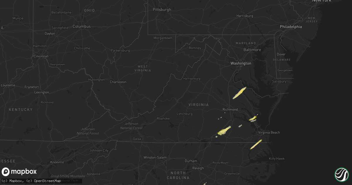
Hail Map in Virginia on February 21, 2014
Get this storm
February 21 map
$229
one time, instant access
Download today. No call, no setup
Keep the $229
Bought the map and want the full workflow? Apply the entire $229 to a subscription within 7 days. None of it is wasted.
Every map, not just this one
This buys you this map. Subscription and you get every map we run, in the markets you choose from a few cities to whole states to nationwide. Plus real-time alerts the moment a storm fires.
Contact data
Name, contact info, occupancy, even credit band for addresses in the footprint. You go from where it hit to who to call.
Become the source they trust
Unlimited branding weather history reports on demand. You already have the documented answer ready for the property owner, and you are the one who showed up with it.
Property data and RoofTrace estimates
Pull up any address you have got, its value and the exact code rules for that jurisdiction, straight from One Click Code. Then RoofTrace estimates the squares, pitch, and roof value, priced the way you price.
Storm reports in Virginia
Virginia
| Date | Description |
|---|---|
| 02/21/20141:35 PM CST | Tree down onto a house. |
| 02/21/20141:27 PM CST | Several trees down. |
| 02/21/20141:27 PM CST | A local report indicates 1.00 inch wind near 1 WSW SAINT BRIDES |
| 02/21/201412:13 PM CST | Trees down. |
| 02/21/201412:11 PM CST | Trees down...damage to sheds. |
| 02/21/201412:10 PM CST | Trees down along pinetta road. |
| 02/21/201412:10 PM CST | Numerous trees snapped. |
| 02/21/201412:10 PM CST | Trees and power lines down in the cobbs creek area. |
| 02/21/201412:09 PM CST | Numerous trees down or snapped off. Minor damage to roofs. |
| 02/21/201412:05 PM CST | Widespread damage across an area 13 miles long. Mobile homes shifted off foundations...minor roof damage to homes. Damage to a greenhouse and part of a produce packing |
| 02/21/201412:00 PM CST | Widespread damage across southern gloucester from river park road to tidemill road. Property damage with numerous trees down. |
| 02/21/201411:50 AM CST | Awos jgg williamburg airport |
| 02/21/201411:50 AM CST | Trees down blocking route 5 near chicohominy park. |
| 02/21/201411:40 AM CST | Tree on a car. Several trees down across the area. |
| 02/21/201411:30 AM CST | Large tree down on hines road |
| 02/21/201411:28 AM CST | Trees down in the howerton area. |
| 02/21/201411:23 AM CST | Numerous trees down along loving union road. |
| 02/21/201411:20 AM CST | Multiple trees and power lines down |
| 02/21/201411:17 AM CST | Numerous trees down along courtland road. |
| 02/21/201411:17 AM CST | Several trees down along courtland road between templeton rd. And log rd. |
| 02/21/201411:15 AM CST | Excessive amount of downed trees...more than 10 and finding more via county emt |
| 02/21/201411:15 AM CST | Multiple trees and power lines down |
| 02/21/201411:15 AM CST | Multiple trees and power lines down |
| 02/21/201411:12 AM CST | Ef0 tornado downed or sheared off numerous trees over a 0.8 mile by 25 yard path that ended about 1.5 miles ne of foneswood. |
| 02/21/201411:12 AM CST | Excessive amount of downed trees...more than 10 and finding more via county emt |
| 02/21/201411:12 AM CST | Roof off a house on flat iron road in the bainsville area. Numerous trees and power lines down. |
| 02/21/201411:10 AM CST | Quarter size hail. |
| 02/21/201411:10 AM CST | Trees down along the 7300 block of elko road. |
| 02/21/201411:10 AM CST | Trees down along pinetta road. |
| 02/21/201411:10 AM CST | Trees down. Farm sheds damaged. |
| 02/21/201411:08 AM CST | Large tree down across baugh rd. |
| 02/21/201411:08 AM CST | Numerous trees snapped and uprooted along hardwood creek road...courthouse road and bolsters road. Outbuidings destroyed. Possible torando reported by emergency officia |
| 02/21/201411:08 AM CST | All outbuildings on a farm destoyed on baugh road north of stony creek. |
| 02/21/201411:07 AM CST | Trees down along with lost of dime size hail. Very high wind 60 mph and greater. |
| 02/21/201411:05 AM CST | Quarter size hail covering the ground. |
| 02/21/201411:05 AM CST | Large tree down. |
| 02/21/201411:05 AM CST | Power poles and wires down along osborne parkway near herman road. |
| 02/21/201411:03 AM CST | Numerous trees down from stewart road to walkers mill road. |
| 02/21/201411:00 AM CST | Numerous trees down or snapped off from chance northeast to the river. |
| 02/21/201411:00 AM CST | Power lines and trees down along williamsburg and garland roads. |
| 02/21/201411:00 AM CST | Quarter size hail covering the ground. |
| 02/21/201411:00 AM CST | Numerous trees snapped and uprooted along hardwood creek road...courthouse road and bolsters road. Outbuidings damaged. All straight line wind damage via nws survey. |
| 02/21/201411:00 AM CST | Treesd own or snapped off. Barn damaged. |
| 02/21/201411:00 AM CST | Numerous trees down across northern essex county. |
| 02/21/201410:55 AM CST | Trees down. |
| 02/21/201410:50 AM CST | Trees down river road and graves road. |
| 02/21/201410:46 AM CST | Trees down |
| 02/21/201410:41 AM CST | Trees down at chippenham and jahnke rd. |
| 02/21/201410:40 AM CST | Trees down along pinetta road...one fell onto a house. |
| 02/21/201410:40 AM CST | Trees down |
| 02/21/201410:33 AM CST | Trees down |
| 02/21/20149:18 AM CST | A couple of trees down between south boston and scottsburg. Time est from radar. |
| 02/21/20148:12 AM CST | Trees and wires down in callands. Time est from radar. |
| 02/21/20147:50 AM CST | Scattered trees/wires down across henry county. |
| 02/21/20147:35 AM CST | Trees down and damage to a barn roof. Time est from radar. |
All States Impacted by Hail Map on February 21, 2014
Cities Impacted by Hail Map on February 21, 2014
- Dinwiddie, VA
- Stony Creek, VA
- Dewitt, VA
- Dolphin, VA
- Lawrenceville, VA
- Emporia, VA
- Warfield, VA
- Jarratt, VA
- Alberta, VA
- Freeman, VA
- Carson, VA
- McKenney, VA
- Yorktown, VA
- Williamsburg, VA
- Gloucester, VA
- Hayes, VA
- Sanford, FL
- Hustle, VA
- Colonial Beach, VA
- Loretto, VA
- Champlain, VA
- Newtown, VA
- Ruther Glen, VA
- Caret, VA
- Montross, VA
- Aylett, VA
- Tappahannock, VA
- Bowling Green, VA
- Newburg, MD
- Milford, VA
- Midlothian, VA
- Newport News, VA
- Saint Augustine, FL
- Waverly, VA
- Chesapeake, VA
- Sunbury, NC
- Corapeake, NC
- South Mills, NC
- Gatesville, NC
- Hobbsville, NC
- Mims, FL
- Bunnell, FL
- Geneva, FL
- Four Oaks, NC
- Chesterfield, VA
- Brodnax, VA
- White Oak, NC
- Newton Grove, NC
- Dunn, NC
- Benson, NC
- Amelia Court House, VA
- Red Springs, NC
- Fellsmere, FL
- Newberry, FL
- Sebastian, FL
- Roseboro, NC
- Autryville, NC
- Palm City, FL
- Green Cove Springs, FL
- Palatka, FL


