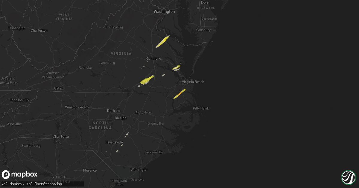
Hail Map on February 21, 2014
Get this storm
February 21 map
$229
one time, instant access
Download today. No call, no setup
Keep the $229
Bought the map and want the full workflow? Apply the entire $229 to a subscription within 7 days. None of it is wasted.
Every map, not just this one
This buys you this map. Subscription and you get every map we run, in the markets you choose from a few cities to whole states to nationwide. Plus real-time alerts the moment a storm fires.
Contact data
Name, contact info, occupancy, even credit band for addresses in the footprint. You go from where it hit to who to call.
Become the source they trust
Unlimited branding weather history reports on demand. You already have the documented answer ready for the property owner, and you are the one who showed up with it.
Property data and RoofTrace estimates
Pull up any address you have got, its value and the exact code rules for that jurisdiction, straight from One Click Code. Then RoofTrace estimates the squares, pitch, and roof value, priced the way you price.
States Impacted by Hail Map on February 21, 2014
Storm reports
Maryland
| Date | Description |
|---|---|
| 02/21/20141:23 PM CST | Tree down at catalina drive and clubhouse drive. |
| 02/21/201412:51 PM CST | A farm building was damaged in preston. |
| 02/21/201412:20 PM CST | Trees down on dark road |
| 02/21/201412:10 PM CST | A farm building was damaged in preston. |
| 02/21/201411:55 AM CST | Trees down on dark road |
| 02/21/201411:54 AM CST | Tree down on trapp road |
| 02/21/201411:39 AM CST | Tree down at cove lake road and cove point drive. |
| 02/21/201411:39 AM CST | Tree down on cove point road northwest of cove point. |
| 02/21/201411:38 AM CST | Power lines reported down at two locations on three notch road. |
| 02/21/201411:37 AM CST | Tree down at catalina drive and clubhouse drive. |
| 02/21/201411:37 AM CST | Tree down on soundings road. |
| 02/21/201411:37 AM CST | Tree down at park chesapeake dr and manoe ct |
| 02/21/201411:37 AM CST | Tree down at little cove point road and haltrace drive. |
| 02/21/201411:37 AM CST | Tree down in the 11000 block of rawhide road. |
| 02/21/201411:35 AM CST | Tree down on soundings road. |
| 02/21/201411:34 AM CST | Power lines reported down at two locations on three notch road. |
| 02/21/201411:34 AM CST | Tree down at mccready road and coster road. |
| 02/21/201411:33 AM CST | Trees down in wildewood area west of california md. |
| 02/21/201411:33 AM CST | Trees down on wildewood parkway west of california md. |
| 02/21/201411:32 AM CST | Power lines and power pole down |
| 02/21/201411:32 AM CST | Power lines reported down at two locations on three notch road. |
| 02/21/201411:31 AM CST | Trees down on wildewood parkway west of california md. |
| 02/21/201411:30 AM CST | Three 1.5 foot diameter trees down |
| 02/21/201411:30 AM CST | Power lines down on saint andrews church road. |
| 02/21/201411:29 AM CST | Multiple large trees down closed fairgrounds rd |
| 02/21/201411:27 AM CST | Two trees down on point lookout road near leonardstown high school. |
| 02/21/201411:26 AM CST | Multiple large trees down closed fairgrounds rd |
| 02/21/201411:23 AM CST | Tree reported down on breton beach road. |
| 02/21/201411:23 AM CST | Ef0 tornado from 1223 pm est to 1239 pm est. Tornado damage first reported in compton in st. Marys county md and last damage reported was near cove point in calvert cou |
| 02/21/201411:20 AM CST | Tree reported down on breton beach road. |
| 02/21/201411:15 AM CST | Tree reported down on maddox road in bushwood. |
Virginia
| Date | Description |
|---|---|
| 02/21/20141:35 PM CST | Tree down onto a house. |
| 02/21/20141:27 PM CST | A local report indicates 1.00 inch wind near 1 WSW SAINT BRIDES |
| 02/21/20141:27 PM CST | Several trees down. |
| 02/21/201412:13 PM CST | Trees down. |
| 02/21/201412:11 PM CST | Trees down...damage to sheds. |
| 02/21/201412:10 PM CST | Numerous trees snapped. |
| 02/21/201412:10 PM CST | Trees down along pinetta road. |
| 02/21/201412:10 PM CST | Trees and power lines down in the cobbs creek area. |
| 02/21/201412:09 PM CST | Numerous trees down or snapped off. Minor damage to roofs. |
| 02/21/201412:05 PM CST | Widespread damage across an area 13 miles long. Mobile homes shifted off foundations...minor roof damage to homes. Damage to a greenhouse and part of a produce packing |
| 02/21/201412:00 PM CST | Widespread damage across southern gloucester from river park road to tidemill road. Property damage with numerous trees down. |
| 02/21/201411:50 AM CST | Trees down blocking route 5 near chicohominy park. |
| 02/21/201411:50 AM CST | Awos jgg williamburg airport |
| 02/21/201411:40 AM CST | Tree on a car. Several trees down across the area. |
| 02/21/201411:30 AM CST | Large tree down on hines road |
| 02/21/201411:28 AM CST | Trees down in the howerton area. |
| 02/21/201411:23 AM CST | Numerous trees down along loving union road. |
| 02/21/201411:20 AM CST | Multiple trees and power lines down |
| 02/21/201411:17 AM CST | Several trees down along courtland road between templeton rd. And log rd. |
| 02/21/201411:17 AM CST | Numerous trees down along courtland road. |
| 02/21/201411:15 AM CST | Multiple trees and power lines down |
| 02/21/201411:15 AM CST | Multiple trees and power lines down |
| 02/21/201411:15 AM CST | Excessive amount of downed trees...more than 10 and finding more via county emt |
| 02/21/201411:12 AM CST | Ef0 tornado downed or sheared off numerous trees over a 0.8 mile by 25 yard path that ended about 1.5 miles ne of foneswood. |
| 02/21/201411:12 AM CST | Roof off a house on flat iron road in the bainsville area. Numerous trees and power lines down. |
| 02/21/201411:12 AM CST | Excessive amount of downed trees...more than 10 and finding more via county emt |
| 02/21/201411:10 AM CST | Trees down along pinetta road. |
| 02/21/201411:10 AM CST | Quarter size hail. |
| 02/21/201411:10 AM CST | Trees down. Farm sheds damaged. |
| 02/21/201411:10 AM CST | Trees down along the 7300 block of elko road. |
| 02/21/201411:08 AM CST | Large tree down across baugh rd. |
| 02/21/201411:08 AM CST | All outbuildings on a farm destoyed on baugh road north of stony creek. |
| 02/21/201411:08 AM CST | Numerous trees snapped and uprooted along hardwood creek road...courthouse road and bolsters road. Outbuidings destroyed. Possible torando reported by emergency officia |
| 02/21/201411:07 AM CST | Trees down along with lost of dime size hail. Very high wind 60 mph and greater. |
| 02/21/201411:05 AM CST | Large tree down. |
| 02/21/201411:05 AM CST | Power poles and wires down along osborne parkway near herman road. |
| 02/21/201411:05 AM CST | Quarter size hail covering the ground. |
| 02/21/201411:03 AM CST | Numerous trees down from stewart road to walkers mill road. |
| 02/21/201411:00 AM CST | Treesd own or snapped off. Barn damaged. |
| 02/21/201411:00 AM CST | Quarter size hail covering the ground. |
| 02/21/201411:00 AM CST | Numerous trees down across northern essex county. |
| 02/21/201411:00 AM CST | Power lines and trees down along williamsburg and garland roads. |
| 02/21/201411:00 AM CST | Numerous trees down or snapped off from chance northeast to the river. |
| 02/21/201411:00 AM CST | Numerous trees snapped and uprooted along hardwood creek road...courthouse road and bolsters road. Outbuidings damaged. All straight line wind damage via nws survey. |
| 02/21/201410:55 AM CST | Trees down. |
| 02/21/201410:50 AM CST | Trees down river road and graves road. |
| 02/21/201410:46 AM CST | Trees down |
| 02/21/201410:41 AM CST | Trees down at chippenham and jahnke rd. |
| 02/21/201410:40 AM CST | Trees down |
| 02/21/201410:40 AM CST | Trees down along pinetta road...one fell onto a house. |
| 02/21/201410:33 AM CST | Trees down |
| 02/21/20149:18 AM CST | A couple of trees down between south boston and scottsburg. Time est from radar. |
| 02/21/20148:12 AM CST | Trees and wires down in callands. Time est from radar. |
| 02/21/20147:50 AM CST | Scattered trees/wires down across henry county. |
| 02/21/20147:35 AM CST | Trees down and damage to a barn roof. Time est from radar. |
South Carolina
| Date | Description |
|---|---|
| 02/21/201410:50 AM CST | Power lines were reported down at the intersection of chelsea lane and highway 381. |
| 02/21/201410:50 AM CST | Hwy dept. Reported power outages in holly hill and the surrounding area. |
| 02/21/201410:20 AM CST | A tree was reported down across the roadway at the intersection of levenworth road and dovesville highway. |
Florida
| Date | Description |
|---|---|
| 02/21/20144:00 PM CST | Aluminum porch roof of mobile home on tangelo drive ne peeled back with additional roof damage to dining room addition. |
| 02/21/20141:32 PM CST | Skywarn spotter had quarter size hail in the grand haven subdivision of palm coast. |
| 02/21/201412:20 PM CST | A storm spotter reported winds of around 55 mph up to 60 mph along i-95 west to northwest of the st augustine area. |
| 02/21/201412:20 PM CST | Emergency management reported dime to quarter size hail on florida 16 near interstate 95. Hail lasted for approximately 10 minutes...ending at 130 pm. |
| 02/21/20148:15 AM CST | Tree limbs down in northwest madison county near us 221. |
Georgia
| Date | Description |
|---|---|
| 02/21/201410:40 AM CST | Strong gusty winds and large tree down |
| 02/21/20149:30 AM CST | Trees down in the park. A tour boat was caught out and had to be brought in. |
| 02/21/20149:30 AM CST | Two large trees damaged a building just off u.s. Highway 84 about one mile south of the altamaha river. |
| 02/21/20149:30 AM CST | Ema surveyed damage with noted metal shed damaged with 10 to 12 trees down. Damage area about 100 yards wide and 100 yards long. Located near williams road and tank roa |
| 02/21/20149:30 AM CST | Ema reported damage to a barn and trees down near williams road. Time estimated from radar. |
| 02/21/20148:55 AM CST | Jefferson electric reported a fire on hwy 24 southeast of waynesboro from down powerlines. |
| 02/21/20148:40 AM CST | Numerous trees down at highway 221 and shiner pond road. |
| 02/21/20148:35 AM CST | Trees down in the western part of the county. |
| 02/21/20148:25 AM CST | Some wind damage to structures along sportsman cove road south of valdosta. Some roofing material peeled off a few buildings and some trees downed. |
| 02/21/20148:25 AM CST | Trees down in southern lowndes county. A few trees down across i-75 |
| 02/21/20148:10 AM CST | Numerous trees down across coffe county |
| 02/21/20148:05 AM CST | Uprooted trees and large tree branches broken. |
| 02/21/20148:00 AM CST | Trees down in central brooks county. |
| 02/21/20147:45 AM CST | Small trees down in the southeastern part of irwin county. |
| 02/21/20147:38 AM CST | Nws storm survey confirmed tornado in laurens county continued into johnson county. Tornado start time 821 am...tornado end time 841 am. See pns for more details. |
| 02/21/20147:35 AM CST | Trees down all across tifton with some on houses. |
| 02/21/20147:33 AM CST | Tree damage in the city of tifton. A couple trees blown down on vehicles or residences. Metal roofing off a building along beech street. A couple street signs blown dow |
| 02/21/20147:29 AM CST | Brief ef0 tornado on the western outskirts of tifton... Just to the south of highway 82. Path length approx 2.3 miles. Path width approx 300 yards. Peak gusts around 80 |
| 02/21/20147:28 AM CST | Irrigation pivot flipped along isabella-nashville road to the southwest of the beginning of a tornado. More concentrated tree damage just east along salem church rd as |
| 02/21/20147:21 AM CST | Nws storm survey confirmed a tornado touched down just east of the dublin airport. Tornado start time 821 am...tornado end time 841 am in johnson county. See pns for mo |
| 02/21/20147:20 AM CST | Possible tornado trees down and houses damaged north of dublin. One house was destroyed off of claxton dairy road just east of the dublin county airport. In the holly i |
| 02/21/20147:15 AM CST | Numerous trees uprooted and snapped on south broad street. |
| 02/21/20147:15 AM CST | Southwest path of uprooted trees form evergreen rd. To liberty hill. Possible tornado. |
| 02/21/20147:06 AM CST | Trees down on cranford road in grady county. |
| 02/21/20147:05 AM CST | Wind damage concentrated near the intersection of carlton rd and highway 133 was determined to be caused by a microburst. Damage was consistently blown to the northeast |
| 02/21/20146:00 AM CST | Tree down on 3 notch rd and mayhaw. |
Kentucky
| Date | Description |
|---|---|
| 02/21/20147:30 AM CST | County-wide damage. Tree down near the us 119 exit on ky 194. Tree down at the mouth of red creek on us 460. Tree down on ky 319 near the foot of hardy mountain on the |
| 02/21/20147:08 AM CST | Report made by big sandy recc. This is a county-wide report of downed trees and powerlines. 10 outages have been reported. |
| 02/21/20147:08 AM CST | Report made by big sandy recc. This is a county-wide report of downed trees and powerlines with 3 outages reported. |
| 02/21/20147:08 AM CST | Report made by big sandy recc. This is a county-wide report of downed trees and powerlines with 3 outages reported. |
North Carolina
| Date | Description |
|---|---|
| 02/21/20141:35 PM CST | Tree down on burney town rd |
| 02/21/20141:27 PM CST | 911 center reported trees down throughout the county. |
| 02/21/20141:18 PM CST | 1 block s of intersection of hwy 41 and 24. Gazeboo full of plants blown over. Radar estimated. |
| 02/21/20141:15 PM CST | Portable car port blown across the road. |
| 02/21/20141:15 PM CST | Large tree down across hwy 13 |
| 02/21/20141:10 PM CST | Tree on house |
| 02/21/20141:05 PM CST | Trees down on strickland road. Radar estimated. |
| 02/21/20141:01 PM CST | Tree down across sand pit road. Radar estimated |
| 02/21/20141:00 PM CST | Four to five trees down near penderlea hwy and basden rd - time estimated based on radar |
| 02/21/201412:55 PM CST | Spotter measured a 69 mph wind gust off of a vortex brand car mounted anemometer |
| 02/21/201412:50 PM CST | Open air canopy roof ripped off a building at blueberry rd and hwy 210 - time estimated based on radar |
| 02/21/201412:49 PM CST | Measured from a home weather station |
| 02/21/201412:47 PM CST | One tree down on a house on combs rd. |
| 02/21/201412:46 PM CST | One tree down on nahunta rd...near hwy 581. |
| 02/21/201412:45 PM CST | Couple of trees down in the princeton area |
| 02/21/201412:44 PM CST | One tree down on salem church rd. |
| 02/21/201412:25 PM CST | Nws damage survey revealed ef-1 damage to an office trailer and surrounding trees that were uplifted and tossed on to nearby tree canopy. |
| 02/21/201412:25 PM CST | Tree down on suttontown road |
| 02/21/201412:25 PM CST | Abandoned mobile home damaged by wind at 5400 block of us hwy 13. |
| 02/21/201412:23 PM CST | Tree down on bells church road at hwy 701 |
| 02/21/201412:20 PM CST | Tree down on highway 701 north - time estimated based on radar |
| 02/21/201412:18 PM CST | Tree down on bells branch road |
| 02/21/201412:17 PM CST | 2 trees down near church and keener roads |
| 02/21/201412:16 PM CST | Tree down on jones road in newton grove |
| 02/21/201412:09 PM CST | Two to three foot diameter tree uprooted and damaged a fence on alta street - time estimated based on radar |
| 02/21/201412:07 PM CST | Tree down on williams lake road |
| 02/21/201411:59 AM CST | Tree down on bethel church road - time estimated based on radar |
| 02/21/201411:50 AM CST | Tree on vehicle |
| 02/21/201411:50 AM CST | Canopy collapse at smithfield packing facility damaged several vehicles - time estimated based on radar |
| 02/21/201411:40 AM CST | One tree down near gillespie st and snow hill rd |
| 02/21/201411:40 AM CST | Tree on vehicle |
| 02/21/201411:40 AM CST | Roof off shed. Metal carport beginning to lift up. |
| 02/21/201411:25 AM CST | Multiple trees were reported down. Possible tornado. |
| 02/21/201411:15 AM CST | A home was reportedly damaged near elrod road. Possible tornado. |
| 02/21/201411:08 AM CST | Tree blown down on power line starting fire |
| 02/21/201411:08 AM CST | Tree blown down on power line starting fire |
| 02/21/201410:52 AM CST | One tree down across vass road |
| 02/21/201410:43 AM CST | Tree blown down along walter grissom road. |
| 02/21/201410:35 AM CST | Tree blown down along highway 96. |
| 02/21/201410:25 AM CST | Large tree blown down along caistor lane. |
| 02/21/201410:20 AM CST | Large branches blown down along six forks road. |
| 02/21/201410:10 AM CST | Gas station canopy blown over. |
| 02/21/201410:10 AM CST | Tree blown down near highway 85. |
| 02/21/201410:10 AM CST | Tree down on oakwood ave. |
| 02/21/201410:05 AM CST | Tree blown down near kelly road and lee lane. |
| 02/21/20149:52 AM CST | Two trees blown down along joe peed road. |
| 02/21/20149:51 AM CST | Large pine tree blown down and large limbs also down along ellis road near highway 147. |
| 02/21/20149:30 AM CST | Tree blown down along ike brooks road. |
| 02/21/20149:25 AM CST | Trees down across the road 24 27 area...near the county line. |
| 02/21/20149:24 AM CST | Tree blown down |
| 02/21/20149:23 AM CST | Tree blown down along guess road. |
| 02/21/20149:20 AM CST | One tree blown down along highway 24 27 |
| 02/21/20149:11 AM CST | Tree and power lines blown down along highway 109 south. |
| 02/21/20149:11 AM CST | Dot reports 5 trees down near the mangum area near hwy 109 and jack currie rd |
| 02/21/20149:02 AM CST | Tree blown down near the intersection of highway 87 and boywood road. |
| 02/21/20148:40 AM CST | Numerous trees and power lines down in the church street area of greensboro |
| 02/21/20148:25 AM CST | Wall blown over onto a vehicle on third street. Unattended vehicle. No injuries. |
| 02/21/20147:30 AM CST | Trees down in and around king...one possibly on a mobile home. |
| 02/21/20147:20 AM CST | Trees down southwest part of king. Pictures via facebook. |
Cities Impacted by Hail Map on February 21, 2014
- Dinwiddie, VA
- Stony Creek, VA
- Dewitt, VA
- Dolphin, VA
- Lawrenceville, VA
- Emporia, VA
- Warfield, VA
- Jarratt, VA
- Alberta, VA
- Freeman, VA
- Carson, VA
- McKenney, VA
- Yorktown, VA
- Williamsburg, VA
- Gloucester, VA
- Hayes, VA
- Sanford, FL
- Hustle, VA
- Colonial Beach, VA
- Loretto, VA
- Champlain, VA
- Newtown, VA
- Ruther Glen, VA
- Caret, VA
- Montross, VA
- Aylett, VA
- Tappahannock, VA
- Bowling Green, VA
- Newburg, MD
- Milford, VA
- Midlothian, VA
- Newport News, VA
- Saint Augustine, FL
- Waverly, VA
- Chesapeake, VA
- Sunbury, NC
- Corapeake, NC
- South Mills, NC
- Gatesville, NC
- Hobbsville, NC
- Mims, FL
- Bunnell, FL
- Geneva, FL
- Four Oaks, NC
- Chesterfield, VA
- Brodnax, VA
- White Oak, NC
- Newton Grove, NC
- Dunn, NC
- Benson, NC
- Amelia Court House, VA
- Red Springs, NC
- Fellsmere, FL
- Newberry, FL
- Sebastian, FL
- Roseboro, NC
- Autryville, NC
- Palm City, FL
- Green Cove Springs, FL
- Palatka, FL