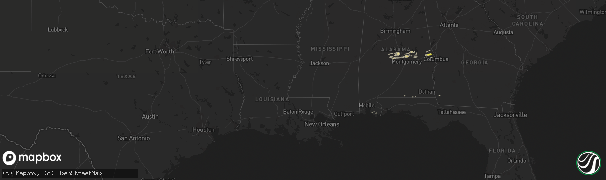
Hail Map in Alabama on February 7, 2018
The weather event in Alabama on February 7, 2018 includes Hail map. 3 states and 37 cities were impacted and suffered possible damage. The total estimated number of properties impacted is 1,005.
Want more than just the map?
Turn this storm into a full workflow.
- Owner + property data so you know who to knock
- OnDemand branded weather history reports to win the "did we even have hail?" argument
- RoofTrace estimate so reps stop guessing numbers at the door
Bought this map? Upgrade within 7 days and we'll credit the $230. (10-15 min setup call)
Hail
1,005
Estimated number of impacted properties by a 1.00" hail or larger0
Estimated number of impacted properties by a 1.75" hail or larger0
Estimated number of impacted properties by a 2.50" hail or largerStorm reports in Alabama
Alabama
| Date | Description |
|---|---|
| 02/07/201812:14 PM CST | 6 mobile homes damaged. 1 with significant damage. |
| 02/07/201812:12 PM CST | Tree down across the carport of a residence. |
| 02/07/20187:27 AM CST | Report of uprooted trees in jemison from social media. |
| 02/07/20187:16 AM CST | Nws meteorologists surveyed damage in extreme southern marengo county and determined it was the result of a tornado. The tornado touched down in the nicholsville commun |
| 02/07/20187:04 AM CST | Nws meteorologists surveyed damage in central autauga county and determined that the damage was consistent with an ef0 tornado. The tornado touched down just to the wes |
| 02/07/20186:49 AM CST | Debris in roadway near intersection of alabama highway 191 and u.s. Highway 31 in jemison. |
| 02/07/20186:40 AM CST | Corrects previous tstm wnd dmg report from jemison. Report of uprooted trees in jemison from social media. Corrected for estimated time. |
| 02/07/20186:37 AM CST | Tree fell across railroad tracks near jemison. |
| 02/07/20186:15 AM CST | Tree reported down near cuba. |
| 02/07/20186:05 AM CST | Corrects previous tstm wnd dmg report from jemison. Tree fell across railroad tracks near jemison. Corrected event time. |
| 02/07/20186:05 AM CST | Corrects previous tstm wnd dmg report from jemison. Debris in roadway near intersection of alabama highway 191 and u.s. Highway 31 in jemison. Corrected event time. |
| 02/07/20186:05 AM CST | Roof damage to at least 2 structures at the intersection of church st and 25th st... And multiple trees down in the surrounding area. Reports/photos via social media. T |
| 02/07/20186:03 AM CST | A tornado began near cr-42 and cr-25 and produced very minor damage along cr-42 until it reached the intersection of cr-42 and cr-38. Here... The tornado intensified an |
| 02/07/20184:34 AM CST | At 1034 AM CST, a severe thunderstorm was located 5 miles north of Laurel Hill, or 9 miles west of Florala, moving east at 35 mph. HAZARD...60 mph wind gusts and quarter size hail. SOURCE...Radar indicated. IMPACT...Hail damage to vehicles is expected. Expect wind damage to roofs, siding, and trees. Locations impacted include... Florala and Lockhart. |
| 02/07/20184:25 AM CST | At 1025 AM CST, a severe thunderstorm was located near Perdido Beach, or 8 miles north of Orange Beach, moving east at 45 mph. HAZARD...60 mph wind gusts and quarter size hail. SOURCE...Radar indicated. IMPACT...Hail damage to vehicles is expected. Expect wind damage to roofs, siding, and trees. Locations impacted include... Pensacola, Ferry Pass, Brent, West Pensacola, Ensley, Warrington, Gulf Breeze, Orange Beach, Goulding, Lillian, Myrtle Grove, Oriole Beach, Navarre, Perdido Beach, Elberta, Pensacola Beach and Navarre Beach. |
| 02/07/20181:02 AM CST | At 702 AM CST, severe thunderstorms were located along a line extending from Billingsley to near Burnsville, moving east at 45 mph. HAZARD...60 mph wind gusts and penny size hail. SOURCE...Radar indicated. IMPACT...Expect damage to roofs, siding, and trees. Locations impacted include... Prattville, Millbrook, Deatsville, Billingsley, Booth, Plecher, Marbury, Vida Junction, Pooles Crossroads, Dawson Mill and New Prospect. |
| 02/07/201812:23 AM CST | At 623 AM CST, a severe thunderstorm was located 7 miles southeast of Marion, moving east at 50 mph. HAZARD...60 mph wind gusts. SOURCE...Radar indicated. IMPACT...Expect damage to roofs, siding, and trees. Locations impacted include... Valley Grande, Paul M Grist State Park, Valley Creek Junction, Plantersville, Suttle, Radford, Sprott, Barrett Creek and Summerfield. |
| 02/06/201811:46 PM CST | At 546 AM CST, severe thunderstorms were located along a line extending from near Greensboro Municipal Airport to 6 miles north of Chickasaw State Park to near Jefferson, moving east at 50 mph. HAZARD...60 mph wind gusts and penny size hail. SOURCE...Radar indicated. IMPACT...Expect damage to roofs, siding, and trees. Locations impacted include... Demopolis, Marion, Greensboro, Linden, Uniontown, Jefferson, Newbern, Faunsdale, Dayton, Greensboro Municipal Airport, Vaiden, Pin Hook, Arcola, Chickasaw State Park, Perry County Correctional Center, Judson College, Old Spring Hill, Gallion, Folsom and Vaiden Field Airport. |
| 02/06/201810:13 PM CST | At 413 AM CST, a severe thunderstorm was located near Duffee, or 13 miles west of Meridian, moving east at 45 mph. HAZARD...60 mph wind gusts and quarter size hail. SOURCE...Radar indicated. IMPACT...Hail damage to vehicles is expected. Expect wind damage to roofs, siding, and trees. This severe thunderstorm will be near... Meridian, Suqualena and Nellieburg around 425 AM CST. Marion and Daleville around 435 AM CST. Meridian Station around 440 AM CST. Toomsuba around 445 AM CST. Lauderdale and Kewanee around 450 AM CST. Other locations impacted by this severe thunderstorm include Chunky. |
Cities Impacted by Hail Map on February 7, 2018
- Tallassee, AL
- Billingsley, AL
- Prattville, AL
- Jones, AL
- Plantersville, AL
- Verbena, AL
- Marbury, AL
- Selma, AL
- Florala, AL
- Iron City, GA
- Colquitt, GA
- Donalsonville, GA
- Autaugaville, AL
- Wetumpka, AL
- Booth, AL
- Elmore, AL
- Coosada, AL
- Millbrook, AL
- Deatsville, AL
- Salem, AL
- Opelika, AL
- Elberta, AL
- Foley, AL
- Auburn, AL
- Titus, AL
- Alexander City, AL
- Equality, AL
- Eclectic, AL
- Samson, AL
- Cusseta, AL
- Valley, AL
- Muldoon, TX
- Geneva, AL
- Phenix City, AL
- Smiths Station, AL
- Hamilton, GA
- Dadeville, AL


