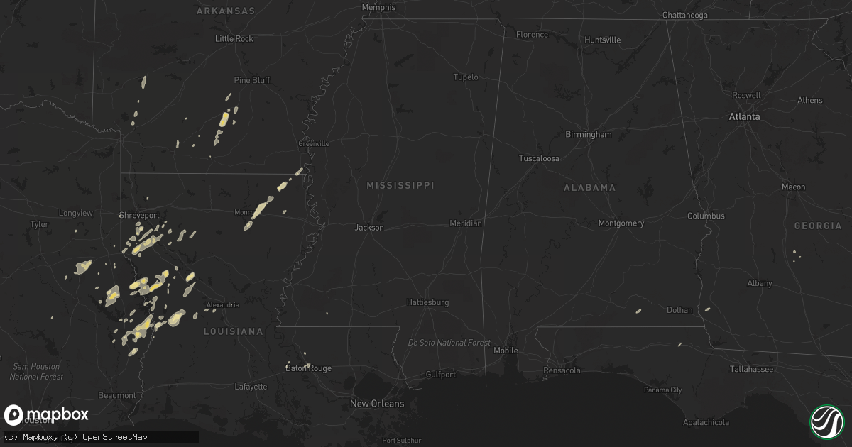
Hail Map in Texas on February 1, 2011
Get this storm
February 1 map
$229
one time, instant access
Download today. No call, no setup
Keep the $229
Bought the map and want the full workflow? Apply the entire $229 to a subscription within 7 days. None of it is wasted.
Every map, not just this one
This buys you this map. Subscription and you get every map we run, in the markets you choose from a few cities to whole states to nationwide. Plus real-time alerts the moment a storm fires.
Contact data
Name, contact info, occupancy, even credit band for addresses in the footprint. You go from where it hit to who to call.
Become the source they trust
Unlimited branding weather history reports on demand. You already have the documented answer ready for the property owner, and you are the one who showed up with it.
Property data and RoofTrace estimates
Pull up any address you have got, its value and the exact code rules for that jurisdiction, straight from One Click Code. Then RoofTrace estimates the squares, pitch, and roof value, priced the way you price.
Storm reports in Texas
Texas
| Date | Description |
|---|---|
| 02/01/20118:44 AM CST | Tree down along hwy 105 in south vidor |
| 02/01/20118:44 AM CST | Power lines down in rose city and vidor |
| 02/01/20117:00 AM CST | Numerous trees down across brazoria county. |
| 02/01/20117:00 AM CST | Sheriffs office reports numerous trees down across the county. |
| 02/01/20116:50 AM CST | Trees down in the community smithland |
| 02/01/20116:48 AM CST | Trees down across harrison county on hwy 59 |
| 02/01/20116:45 AM CST | Trees down across chimney rock...fountain view...and north post oak roads in houston. |
| 02/01/20116:30 AM CST | Trees down in onalaska and livingston. Roof blown off house in livingston. |
| 02/01/20116:10 AM CST | An ef1 tornado touched down at oak hill texas. Damage path was 1/2 mile long and 100 yards wide. Damage consisted of 2 homes damaged...with about 1/2 of the roof torn o |
| 02/01/20116:06 AM CST | 2 homes damaged in oak hill north of henderson |
| 02/01/20116:00 AM CST | Trees down across the road at the intersections of avenue a and texas...cornell and elm...and in the 800 block of north alabama in the city of wharton. |
| 02/01/20116:00 AM CST | Wind damage on hwy 64 just west of henderson texas. Winds of 80-90 mph knocked down trees and powerlines and took the roof off a mobile home. |
All States Impacted by Hail Map on February 1, 2011
Cities Impacted by Hail Map on February 1, 2011
- Nacogdoches, TX
- Garrison, TX
- Mount Enterprise, TX
- Jasper, TX
- Hineston, LA
- Leesville, LA
- Coushatta, LA
- Milam, TX
- Robeline, LA
- Chireno, TX
- Carthage, TX
- Mansfield, LA
- Cottondale, FL
- Ringgold, LA
- Shreveport, LA
- Grand Cane, LA
- Hampton, AR
- Kingsland, AR
- Montgomery, LA
- Natchez, LA
- Natchitoches, LA
- Melrose, LA
- Cloutierville, LA
- Frierson, LA
- Stonewall, LA
- Nashville, AR
- Otis, LA
- Elmer, LA
- Benton, LA
- Many, LA
- Zwolle, LA
- Noble, LA
- Florien, LA
- Groveton, TX
- Collinston, LA
- Monroe, LA
- Oak Ridge, LA
- Jones, LA
- Oak Grove, LA
- Bronson, TX
- Hemphill, TX
- Eudora, AR
- Douglass, TX
- Elm Grove, LA
- Logansport, LA
- Kirbyville, TX
- Newton, TX
- Wiergate, TX
- Burkeville, TX
- Evans, LA
- San Augustine, TX
- Broaddus, TX
- Cordele, GA
- Oscar, LA
- Brookeland, TX
- Keatchie, LA
- Gloster, LA
- Center, TX
- Call, TX
- Fort Polk, LA
- Fordyce, AR
- Thornton, AR
- Anacoco, LA
- Merryville, LA
- Belmont, LA
- El Dorado, AR
- Castor, LA
- Warren, AR
- Banks, AR
- Fulton, AR
- McNeil, AR
- Stephens, AR
- Magnolia, AR
- Waskom, TX
- Greenwood, LA
- Zachary, LA
- Liberty, MS
- Henderson, TX
- Keithville, LA
- Baton Rouge, LA
- Mer Rouge, LA
- Rayville, LA
- Heflin, LA
- West Monroe, LA
- Woodworth, LA
- Columbus, AR
- Washington, AR
- Deville, LA
- Bon Wier, TX
- Bienville, LA
- Saline, LA
- Kirby, AR
- Amity, AR
- Murfreesboro, AR
- Blakely, GA
- Port Allen, LA
- Rosedale, LA
- Louann, AR
- Rison, AR
- Etoile, TX
- Lena, LA
- Provencal, LA
- Samson, AL
- Coffee Springs, AL
- Ashland, LA
- Delhi, LA
- Pitts, GA
- Slagle, LA
- Pitkin, LA
- Deridder, LA
- Camden, AR
- New Edinburg, AR
- Chidester, AR


