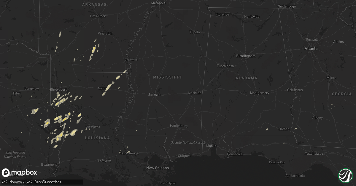
Hail Map in Mississippi on February 1, 2011
Get this storm
February 1 map
$229
one time, instant access
Download today. No call, no setup
Keep the $229
Bought the map and want the full workflow? Apply the entire $229 to a subscription within 7 days. None of it is wasted.
Every map, not just this one
This buys you this map. Subscription and you get every map we run, in the markets you choose from a few cities to whole states to nationwide. Plus real-time alerts the moment a storm fires.
Contact data
Name, contact info, occupancy, even credit band for addresses in the footprint. You go from where it hit to who to call.
Become the source they trust
Unlimited branding weather history reports on demand. You already have the documented answer ready for the property owner, and you are the one who showed up with it.
Property data and RoofTrace estimates
Pull up any address you have got, its value and the exact code rules for that jurisdiction, straight from One Click Code. Then RoofTrace estimates the squares, pitch, and roof value, priced the way you price.
Storm reports in Mississippi
Mississippi
| Date | Description |
|---|---|
| 02/01/20114:27 PM CST | A couple trees down in the hopewell community. |
| 02/01/20113:14 PM CST | A tree and a power line down in the elwood community along cr 121. |
| 02/01/20112:46 PM CST | A tree and a power line down along old hwy 11. |
| 02/01/20112:34 PM CST | A tree and power lines down at the intersection of cr 23 and 16. |
| 02/01/20112:28 PM CST | A few trees were blown down. |
| 02/01/20112:11 PM CST | A couple trees down in the hopewell community. |
| 02/01/20111:50 PM CST | A couple trees were downed across polk-oatis road. Time estimated. Delayed report. |
| 02/01/20111:33 PM CST | Trees and power lines down along highway 583 |
| 02/01/20111:07 PM CST | Tree down across highway 583 |
| 02/01/20111:02 PM CST | Tree down in norfield which is blocking highway 51 |
| 02/01/201112:55 PM CST | Tree and power lines down on erie lane. |
| 02/01/201112:40 PM CST | Tree blown down on hiway 567. Reported by sheriffs office. |
| 02/01/201111:50 AM CST | A tree and a power line down along hwy 553. |
| 02/01/201111:30 AM CST | Three trees and 2 power lines knocked down. |
| 02/01/201110:40 AM CST | Nickel to quarter sized hail reported in the town of mantachie. |
All States Impacted by Hail Map on February 1, 2011
Cities Impacted by Hail Map on February 1, 2011
- Nacogdoches, TX
- Garrison, TX
- Mount Enterprise, TX
- Jasper, TX
- Hineston, LA
- Leesville, LA
- Coushatta, LA
- Milam, TX
- Robeline, LA
- Chireno, TX
- Carthage, TX
- Mansfield, LA
- Cottondale, FL
- Ringgold, LA
- Shreveport, LA
- Grand Cane, LA
- Hampton, AR
- Kingsland, AR
- Montgomery, LA
- Natchez, LA
- Natchitoches, LA
- Melrose, LA
- Cloutierville, LA
- Frierson, LA
- Stonewall, LA
- Nashville, AR
- Otis, LA
- Elmer, LA
- Benton, LA
- Many, LA
- Zwolle, LA
- Noble, LA
- Florien, LA
- Groveton, TX
- Collinston, LA
- Monroe, LA
- Oak Ridge, LA
- Jones, LA
- Oak Grove, LA
- Bronson, TX
- Hemphill, TX
- Eudora, AR
- Douglass, TX
- Elm Grove, LA
- Logansport, LA
- Kirbyville, TX
- Newton, TX
- Wiergate, TX
- Burkeville, TX
- Evans, LA
- San Augustine, TX
- Broaddus, TX
- Cordele, GA
- Oscar, LA
- Brookeland, TX
- Keatchie, LA
- Gloster, LA
- Center, TX
- Call, TX
- Fort Polk, LA
- Fordyce, AR
- Thornton, AR
- Anacoco, LA
- Merryville, LA
- Belmont, LA
- El Dorado, AR
- Castor, LA
- Warren, AR
- Banks, AR
- Fulton, AR
- McNeil, AR
- Stephens, AR
- Magnolia, AR
- Waskom, TX
- Greenwood, LA
- Zachary, LA
- Liberty, MS
- Henderson, TX
- Keithville, LA
- Baton Rouge, LA
- Mer Rouge, LA
- Rayville, LA
- Heflin, LA
- West Monroe, LA
- Woodworth, LA
- Columbus, AR
- Washington, AR
- Deville, LA
- Bon Wier, TX
- Bienville, LA
- Saline, LA
- Kirby, AR
- Amity, AR
- Murfreesboro, AR
- Blakely, GA
- Port Allen, LA
- Rosedale, LA
- Louann, AR
- Rison, AR
- Etoile, TX
- Lena, LA
- Provencal, LA
- Samson, AL
- Coffee Springs, AL
- Ashland, LA
- Delhi, LA
- Pitts, GA
- Slagle, LA
- Pitkin, LA
- Deridder, LA
- Camden, AR
- New Edinburg, AR
- Chidester, AR


