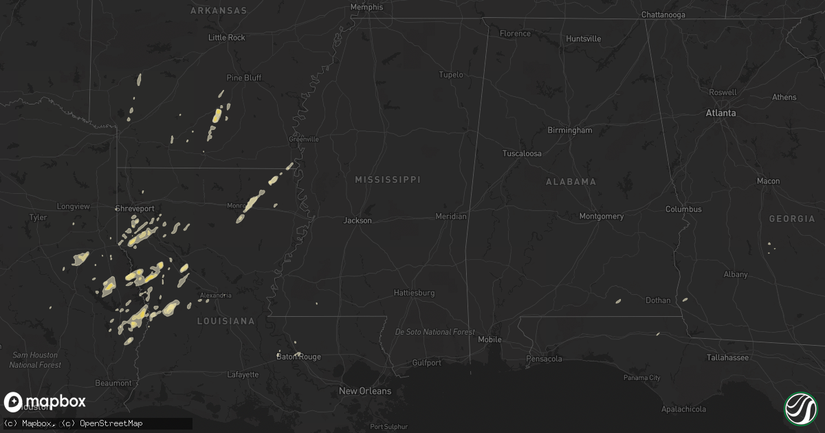
Hail Map in Louisiana on February 1, 2011
Get this storm
February 1 map
$229
one time, instant access
Download today. No call, no setup
Keep the $229
Bought the map and want the full workflow? Apply the entire $229 to a subscription within 7 days. None of it is wasted.
Every map, not just this one
This buys you this map. Subscription and you get every map we run, in the markets you choose from a few cities to whole states to nationwide. Plus real-time alerts the moment a storm fires.
Contact data
Name, contact info, occupancy, even credit band for addresses in the footprint. You go from where it hit to who to call.
Become the source they trust
Unlimited branding weather history reports on demand. You already have the documented answer ready for the property owner, and you are the one who showed up with it.
Property data and RoofTrace estimates
Pull up any address you have got, its value and the exact code rules for that jurisdiction, straight from One Click Code. Then RoofTrace estimates the squares, pitch, and roof value, priced the way you price.
Storm reports in Louisiana
Louisiana
| Date | Description |
|---|---|
| 02/01/20112:40 PM CST | Tree blown down on power line. |
| 02/01/20112:00 PM CST | Few trees blown down along with power line. |
| 02/01/20111:45 PM CST | Tree blown down on a house in the killona community. |
| 02/01/20111:20 PM CST | Tree blown down on highway 1049. Reported by kentwood pd. |
| 02/01/20111:00 PM CST | Tree blown down blocking hiway 432 in chipola area. Reported by sheriffs office. |
| 02/01/201112:35 PM CST | Tree blown down. Reported by sheriffs office |
| 02/01/201112:35 PM CST | Tree blown down. Reported by sheriffs office. |
| 02/01/201112:10 PM CST | Pointe coupee sheriffs office reported trees down along highway 411 between livonia and maringouin. |
| 02/01/201111:25 AM CST | Nws storm survey found a 5 mile long by 1/2 mile wide downburst struck from 2 miles sw to 3 miles e of leonville. Minor damage to roofs and skirting of mobile homes occ |
| 02/01/201111:10 AM CST | Few trees and power lines down |
| 02/01/201111:05 AM CST | Nws storm survey found a small microburst struck along primeaux road southeast of morse. One house suffered shingle damage and was shifted but stayed on its blocks. A g |
| 02/01/201110:55 AM CST | Power lines blown down |
| 02/01/201110:53 AM CST | Housed shifted off the foundation...other homes in the area damaged. |
| 02/01/201110:50 AM CST | Tree down across highway 3102 near larto |
| 02/01/201110:48 AM CST | Turbine ventilators blown off roofs of two homes in sweet lake with power outages. Davis wind equipment measured 59 mph wind gust. |
| 02/01/201110:42 AM CST | Trees and power lines down throughout the parish...especially in the ville platte and mamou areas. |
| 02/01/201110:40 AM CST | Trees and power lines reported down in hessmer...marksville and cottonport |
| 02/01/201110:35 AM CST | Marksville today newspaper reported trees down along a line from hessmer to moreauville |
| 02/01/201110:30 AM CST | Evangeline parish emergency manager reported considerable wind damage on the east side of mamou. Several trees and power poles were blown down with minor damage to roof |
| 02/01/201110:30 AM CST | Marksville today newspaper reported many trees down in belledeau with one tree blown down on a truck and another tree blown onto a home on german bayou road |
| 02/01/201110:10 AM CST | Turbine ventilators blown off roofs of two homes in sweet lake with power outages. Davis wind equipment measured 59 mph wind gust. |
| 02/01/201110:05 AM CST | Trees and power lines reported down in hessmer...marksville and cottonport |
| 02/01/20119:24 AM CST | Power outages reported in the longville area |
| 02/01/20119:19 AM CST | Winds estimated at 60 mph in the longville area |
| 02/01/20119:05 AM CST | Trees reported down along hwy 12 near starks and hwy 109 near starks |
| 02/01/20118:44 AM CST | Tree down across hwy 520 north of bell hill road |
| 02/01/20118:26 AM CST | Tree down on hwy 120 near marthaville |
| 02/01/20118:26 AM CST | Tree down across hwy 2 at intersection of hwy 534 |
| 02/01/20118:24 AM CST | An ef0 tornado touched down 5 miles north of many louisiana. Damage path was roughly 6 miles long and 50 yards wide and extended to the east-northeast. Damage consisted |
| 02/01/20118:20 AM CST | Trees downed. |
| 02/01/20118:15 AM CST | Trees down. Time estimated. |
| 02/01/20118:00 AM CST | Tree downed on looney street. |
All States Impacted by Hail Map on February 1, 2011
Cities Impacted by Hail Map on February 1, 2011
- Nacogdoches, TX
- Garrison, TX
- Mount Enterprise, TX
- Jasper, TX
- Hineston, LA
- Leesville, LA
- Coushatta, LA
- Milam, TX
- Robeline, LA
- Chireno, TX
- Carthage, TX
- Mansfield, LA
- Cottondale, FL
- Ringgold, LA
- Shreveport, LA
- Grand Cane, LA
- Hampton, AR
- Kingsland, AR
- Montgomery, LA
- Natchez, LA
- Natchitoches, LA
- Melrose, LA
- Cloutierville, LA
- Frierson, LA
- Stonewall, LA
- Nashville, AR
- Otis, LA
- Elmer, LA
- Benton, LA
- Many, LA
- Zwolle, LA
- Noble, LA
- Florien, LA
- Groveton, TX
- Collinston, LA
- Monroe, LA
- Oak Ridge, LA
- Jones, LA
- Oak Grove, LA
- Bronson, TX
- Hemphill, TX
- Eudora, AR
- Douglass, TX
- Elm Grove, LA
- Logansport, LA
- Kirbyville, TX
- Newton, TX
- Wiergate, TX
- Burkeville, TX
- Evans, LA
- San Augustine, TX
- Broaddus, TX
- Cordele, GA
- Oscar, LA
- Brookeland, TX
- Keatchie, LA
- Gloster, LA
- Center, TX
- Call, TX
- Fort Polk, LA
- Fordyce, AR
- Thornton, AR
- Anacoco, LA
- Merryville, LA
- Belmont, LA
- El Dorado, AR
- Castor, LA
- Warren, AR
- Banks, AR
- Fulton, AR
- McNeil, AR
- Stephens, AR
- Magnolia, AR
- Waskom, TX
- Greenwood, LA
- Zachary, LA
- Liberty, MS
- Henderson, TX
- Keithville, LA
- Baton Rouge, LA
- Mer Rouge, LA
- Rayville, LA
- Heflin, LA
- West Monroe, LA
- Woodworth, LA
- Columbus, AR
- Washington, AR
- Deville, LA
- Bon Wier, TX
- Bienville, LA
- Saline, LA
- Kirby, AR
- Amity, AR
- Murfreesboro, AR
- Blakely, GA
- Port Allen, LA
- Rosedale, LA
- Louann, AR
- Rison, AR
- Etoile, TX
- Lena, LA
- Provencal, LA
- Samson, AL
- Coffee Springs, AL
- Ashland, LA
- Delhi, LA
- Pitts, GA
- Slagle, LA
- Pitkin, LA
- Deridder, LA
- Camden, AR
- New Edinburg, AR
- Chidester, AR


