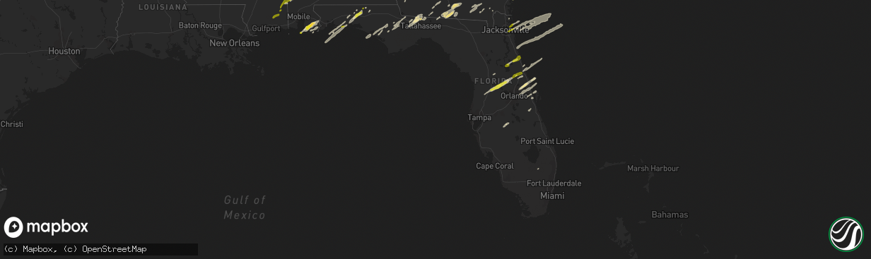
Hail Map in Florida on January 22, 2017
The weather event in Florida on January 22, 2017 includes Hail map. 4 states and 209 cities were impacted and suffered possible damage. The total estimated number of properties impacted is 80,355.
Want more than just the map?
Turn this storm into a full workflow.
- Owner + property data so you know who to knock
- OnDemand branded weather history reports to win the "did we even have hail?" argument
- RoofTrace estimate so reps stop guessing numbers at the door
Bought this map? Upgrade within 7 days and we'll credit the $230. (10-15 min setup call)
Hail
80,355
Estimated number of impacted properties by a 1.00" hail or larger0
Estimated number of impacted properties by a 1.75" hail or larger0
Estimated number of impacted properties by a 2.50" hail or largerStorm reports in Florida
Florida
| Date | Description |
|---|---|
| 01/22/20175:52 PM CST | Dime to quarter size hail reported in tavares. Retweeted post from broadcast media. Time estimated. |
| 01/22/20175:48 PM CST | Picture via twitter of estimated quarter size hail in leesburg. Time estimated. |
| 01/22/20175:30 PM CST | Large oak trees down on house on e hartshorn lane in holder. |
| 01/22/20175:10 PM CST | 50 acre brush fire caused by downed powerlines. Time estimated by radar. |
| 01/22/20175:05 PM CST | Ham radio reported a 1.5 foot diameter tree down. Time estimated by radar. |
| 01/22/20175:04 PM CST | Peak wind gust of 59 mph reported by asos at brooksville hernando county airport |
| 01/22/20174:55 PM CST | *** 1 fatal *** update...emergency manager reported a large tree split a home in half in the lake city area near interstate 10 and u.s. Highway 41. There was 1 fatality |
| 01/22/20174:55 PM CST | Large oak tree down along thompson ave in hudson. |
| 01/22/20174:40 PM CST | Emergency management reported that several downed trees and powerlines along with three structures damaged. |
| 01/22/20174:30 PM CST | Emergency manager reported trees and powerlines down county wide. |
| 01/22/20173:00 PM CST | Numerous trees down |
| 01/22/20172:59 PM CST | Left hand southbound lane of us 98 closed due to trees down |
| 01/22/20172:54 PM CST | I-10 at mile marker 238 closed due to trees down |
| 01/22/20172:54 PM CST | Trees and power lines down over us 90 |
| 01/22/20172:45 PM CST | I-10 eastbound closed at mile marker 203 due to tree in road |
| 01/22/20172:36 PM CST | Trees down at 3506 colonade |
| 01/22/20172:36 PM CST | Trees down at 2700 donovan drive |
| 01/22/20172:36 PM CST | Trees down at 2347 braeburn road |
| 01/22/20172:35 PM CST | Trees down on potts road at noble drive |
| 01/22/20172:35 PM CST | Trees down near keystone heights |
| 01/22/20172:35 PM CST | Trees down near polos on park |
| 01/22/20172:34 PM CST | Trees down at 2983 nutmeg and riverbirch |
| 01/22/20172:34 PM CST | Trees down at 2025 watson way |
| 01/22/20172:34 PM CST | Trees down near miccosukee road |
| 01/22/20172:34 PM CST | Trees down at armistead and thomasville road |
| 01/22/20172:34 PM CST | Trees down on hillgate court |
| 01/22/20172:33 PM CST | Trees down at 1525 coombs drive |
| 01/22/20172:33 PM CST | Trees down at 216 west 2nd ave |
| 01/22/20172:33 PM CST | Trees down at 750 riggins road |
| 01/22/20172:32 PM CST | Trees down on the 1500 block of belmont trace |
| 01/22/20172:32 PM CST | Trees down near devra dr and alton road |
| 01/22/20172:30 PM CST | Trees down at circle dr and magnolia dr |
| 01/22/20172:30 PM CST | Spotter network reported trees down near old jacksonville road in ocala. |
| 01/22/20172:29 PM CST | Trees down at 1749 apalachee parkway |
| 01/22/20172:28 PM CST | Trees down on capital circle ne |
| 01/22/20172:28 PM CST | Trees down at 843 campbell road |
| 01/22/20172:28 PM CST | Trees down at 1427 lynn lane |
| 01/22/20172:28 PM CST | Trees down at 1533 indianhead |
| 01/22/20172:28 PM CST | Trees down on blair stone at lafayette |
| 01/22/20172:28 PM CST | Trees down at 1955 flipper road |
| 01/22/20172:28 PM CST | Trees down at the 1800 block of old fort drive |
| 01/22/20172:28 PM CST | Trees down at 2128 seminole drive |
| 01/22/20172:28 PM CST | Trees down at 1601 golf terrace |
| 01/22/20172:27 PM CST | Trees down on tram road at south monroe street |
| 01/22/20172:27 PM CST | Trees down at 4505 spring hill road |
| 01/22/20172:20 PM CST | Time estimated from radar and report. 4 or 5 oak branches around 2 inches in diameter down on 41st st. Estimated wind speed of 50 mph. 1.50-1.75 inches of rain |
| 01/22/20172:15 PM CST | Several trees and power lines down. Spotter notes all trees fell in same direction. |
| 01/22/20172:10 PM CST | Left hand southbound lane of us 98 closed due to trees down |
| 01/22/20172:04 PM CST | Trees down in crawfordville |
| 01/22/20172:00 PM CST | On top of the world subdivision in ocala had a tree blown into a street lamp with the street lamp on top of a house. |
| 01/22/20172:00 PM CST | Reports of trees down in road |
| 01/22/20171:54 PM CST | Storm survey revealed significant tree damage in the forest. Tornado rated ef1. Lasted from 250 pm until 254 pm. |
| 01/22/20171:52 PM CST | Trees and power lines down in the area with dual-pol tds observed. Also public report of a tornado in the area |
| 01/22/20171:42 PM CST | Cr 157 and bell dr closed due to trees down |
| 01/22/20171:42 PM CST | Trees and power lines down over us 90 |
| 01/22/20171:40 PM CST | Roof damage and large tree in the road |
| 01/22/20171:39 PM CST | I-10 eastbound closed at mile marker 203 due to tree in road |
| 01/22/20171:34 PM CST | A local report indicates 58 MPH wind near MARIANNA |
| 01/22/20171:34 PM CST | Several trees down countywide. Time estimated using radar...operator logs...and kmai wind data. |
| 01/22/20171:30 PM CST | Multiple trees and power lines down countywide |
| 01/22/20171:04 PM CST | Drone runway...tdr |
| 01/22/20171:03 PM CST | 60 mph wind measured at kpam |
| 01/22/20171:00 PM CST | Multiple trees down countywide. Time estimated using radar and operator logs. |
| 01/22/20171:00 PM CST | Multiple reports of trees down countywide. Time estimated using radar and operator logs. |
| 01/22/20171:00 PM CST | Multiple trees and power lines down in greater panama city area. |
| 01/22/201712:45 PM CST | Mesonet station 1 n beverly hills /d1496/. |
| 01/22/201712:40 PM CST | Local tv station received pictures of hail estimated to be around quarter sized along atlantic kernan. The time given was based on radar. |
| 01/22/201712:00 PM CST | Multiple trees and power lines down in defuniak springs and freeport. Time based on radar and operator logs. |
| 01/22/201710:48 AM CST | Hail on hurlburt field. Pictures via social media. |
| 01/22/201710:30 AM CST | Large tree limb snapped in shalimar... Fl |
| 01/22/201710:10 AM CST | Photo received via email. |
| 01/22/20179:32 AM CST | Quarter size hail in cantonment |
| 01/22/20179:30 AM CST | Large tree limb snapped in shalimar... Fl |
| 01/22/20179:25 AM CST | Hail on hurlburt field. Pictures via social media. |
| 01/22/20179:25 AM CST | Quarter sized hail. Pictures from social media. |
| 01/22/20178:45 AM CST | Quater sized hail in navarre... Fl |
| 01/22/20178:00 AM CST | Trees down |
| 01/22/20178:00 AM CST | Several large trees down near killearn lakes and deerlake |
| 01/22/20177:40 AM CST | Public report of quarter size hail in southport |
| 01/22/20176:40 AM CST | Power lines down in northern jefferson county |
| 01/22/20176:15 AM CST | Power lines down near 2061 fairbanks ferry road |
| 01/22/20176:15 AM CST | Tree down on mcclendon lane |
| 01/22/20173:20 AM CST | Multiple trees down in bill baggs cape florida state park |
| 01/22/20172:55 AM CST | Downed power lines... Busted gates and mailboxes near nw 118th street and 5th ave in miami-dade county |
| 01/22/20172:48 AM CST | Ef-1 damage indicated by survey team. Apartment buildings with roof damage. |
| 01/22/20172:46 AM CST | Ef-1 damage indicated by survey team. Large trees toppled...roof and porch damage to single family residences. |
| 01/22/20172:46 AM CST | Tractor trailed overturned near nw 50th st and 74th ave in miami-dade reported by news media |
| 01/22/20172:45 AM CST | Ef-1 damage indicated by survey. Damage to warehouses... Trucks... And shipping containers. |
| 01/22/20172:05 AM CST | Large branch down along with debris scattered at jacaranda golf club |
| 01/22/20171:33 AM CST | Wind gust of 61 mph was measured at 233 am |
| 01/22/201712:47 AM CST | Ef-0 damage confirmed by survey crew. Tree damage. Winds estimated at 70 mph |
| 01/22/201712:45 AM CST | Ef-0 damage confirmed by survey crew. Tree damage. Winds estimated at 75-80 mph |
| 01/22/201712:45 AM CST | In juno beach... Mulitple posts on social media show down power lines... Fallen trees and street signs down. Time estimated by radar. |
| 01/22/201712:40 AM CST | A medium to large sized tree was uprooted off of donald ross road in palm beach gardens. Time estimated by radar. |
| 01/22/201712:39 AM CST | Ef-1 damage confirmed by survey crew. Trees snapped at trunks. Winds estimated at 90 mph |
| 01/21/201711:50 PM CST | Couple trees down in goodland. Time estimated by radar. |
| 01/21/20177:06 PM CST | Mesonet station 3 w macdill air force /optf1/. |
| 01/21/20176:50 PM CST | Several mobile homes with significant roof damage in heather hills estates and casa loma mobile home parks. |
| 01/21/20176:47 PM CST | Measured wind gust of 62 mph/54 kt from the ssw at kevb. |
| 01/21/20176:35 PM CST | Quarter size hail for 3 minutes reported in r section of palm coast. Time of event estimated. |
| 01/21/20176:35 PM CST | Quarter size hail reported in c section of palm coast. |
| 01/21/20176:30 PM CST | Trees in road near intersection of n hercules ave and ridgewood dr. |
| 01/21/20176:19 PM CST | Putnam county em reported a downed tree near state route 100 and sipprell road. |
| 01/21/20176:17 PM CST | Emergency management reported that 2 mobile homes sustained roof damage. Time estimated by radar. |
| 01/21/20176:16 PM CST | Amateur radio operator reported that trees were down near us 19 and flora ave. |
| 01/21/20176:15 PM CST | Twitter picture of tree down in maitland. Location approximate. |
| 01/21/20176:12 PM CST | Picture on twitter of a tree down in the magnolia park area of sanford. Time and location estimated. |
| 01/21/20176:11 PM CST | Asos measured a gust of 53 kt/61 mph from the ssw. |
All States Impacted by Hail Map on January 22, 2017
Cities Impacted by Hail Map on January 22, 2017
- McIntosh, AL
- Arlington, GA
- Damascus, GA
- Morgan, GA
- Leary, GA
- Newton, GA
- Quitman, GA
- Andersonville, GA
- Americus, GA
- Ellaville, GA
- Havana, FL
- Defuniak Springs, FL
- Summerdale, AL
- Foley, AL
- Osteen, FL
- Geneva, FL
- Ashburn, GA
- Warwick, GA
- Arabi, GA
- Rochelle, GA
- Pitts, GA
- Citronelle, AL
- Vinegar Bend, AL
- Leesburg, FL
- Selma, AL
- Leesburg, GA
- Greenville, FL
- Ray City, GA
- Lakeland, GA
- Valdosta, GA
- Moody Afb, GA
- Hahira, GA
- Naylor, GA
- Newville, AL
- Fort Gaines, GA
- Headland, AL
- Shorterville, AL
- Abbeville, AL
- Columbia, AL
- Orlando, FL
- Westville, FL
- Bonifay, FL
- Orange Beach, AL
- Belle Glade, FL
- Oakfield, GA
- Tallahassee, FL
- Atlantic Beach, FL
- Jacksonville, FL
- Deland, FL
- Magnolia Springs, AL
- Fairhope, AL
- Robertsdale, AL
- Elberta, AL
- Quincy, FL
- Midway, FL
- Gulf Shores, AL
- Seminole, AL
- Irwinton, GA
- Danville, GA
- Toomsboro, GA
- Tavares, FL
- Okahumpka, FL
- Oviedo, FL
- Paisley, FL
- Umatilla, FL
- Sumterville, FL
- Groveland, FL
- Eustis, FL
- Bushnell, FL
- Folkston, GA
- Coleman, GA
- Bluffton, GA
- Eglin Afb, FL
- Mary Esther, FL
- Navarre, FL
- Saint Cloud, FL
- Yalaha, FL
- Lynn Haven, FL
- Altha, FL
- Youngstown, FL
- Panama City, FL
- Panama City Beach, FL
- Sparks, GA
- Adel, GA
- Lake Park, GA
- Saint Augustine, FL
- Thomasville, GA
- Frisco City, AL
- Cocoa, FL
- Albany, GA
- Colquitt, GA
- Blakely, GA
- Oglethorpe, GA
- Whigham, GA
- Cairo, GA
- Lucedale, MS
- Willacoochee, GA
- Ambrose, GA
- Blountstown, FL
- Chattahoochee, FL
- Bristol, FL
- Lillian, AL
- Center Hill, FL
- Grand Island, FL
- Frostproof, FL
- New Smyrna Beach, FL
- Ormond Beach, FL
- Daytona Beach, FL
- Alapaha, GA
- Saint Simons Island, GA
- Yulee, FL
- Fernandina Beach, FL
- Dawson, GA
- Valparaiso, FL
- Niceville, FL
- Crestview, FL
- Moultrie, GA
- Pavo, GA
- Ocala, FL
- Jakin, GA
- Crescent City, FL
- Bunnell, FL
- Georgetown, FL
- Palm Coast, FL
- Minter, AL
- Edgewater, FL
- Oak Hill, FL
- Mims, FL
- Christmas, FL
- Abbeville, GA
- Fargo, GA
- The Villages, FL
- Mount Dora, FL
- Brooksville, FL
- Wildwood, FL
- Manor, GA
- Homerville, GA
- Waycross, GA
- Wewahitchka, FL
- Winter Springs, FL
- Fort Walton Beach, FL
- Shalimar, FL
- Billingsley, AL
- Titusville, FL
- Monticello, FL
- Hartford, AL
- Newton, AL
- Coolidge, GA
- Fort Meade, FL
- Babson Park, FL
- Lake Wales, FL
- Plantersville, AL
- Randolph, AL
- Jemison, AL
- Marion Junction, AL
- Calera, AL
- Lawley, AL
- Montevallo, AL
- Marion, AL
- Stanton, AL
- Maplesville, AL
- Hayneville, AL
- Letohatchee, AL
- Eutaw, AL
- Gordo, AL
- Aliceville, AL
- Ozark, AL
- Vancleave, MS
- Perkinston, MS
- Sunflower, AL
- Wagarville, AL
- Tibbie, AL
- Leakesville, MS
- Deer Park, AL
- Hurlburt Field, FL
- De Leon Springs, FL
- Vicksburg, MS
- Roxie, MS
- Hazlehurst, MS
- Fayette, MS
- Union Church, MS
- Wesson, MS
- McCall Creek, MS
- Meadville, MS
- Brookhaven, MS
- Edwards, MS
- Bolton, MS
- Raymond, MS
- Canton, MS
- Vaughan, MS
- Ridgeland, MS
- Madison, MS
- Tougaloo, MS
- Jackson, MS
- Flowood, MS
- Brandon, MS
- Pearl, MS
- Florence, MS
- Forest, MS
- Braxton, MS
- Morton, MS
- Pelahatchie, MS
- Harrisville, MS
- Mendenhall, MS
- Lake, MS
- Raleigh, MS
- Magee, MS
- Neptune Beach, FL
- Jacksonville Beach, FL


