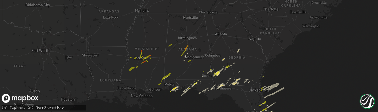
Hail Map in Alabama on January 22, 2017
The weather event in Alabama on January 22, 2017 includes Hail map. 4 states and 209 cities were impacted and suffered possible damage. The total estimated number of properties impacted is 9,818.
Want more than just the map?
Turn this storm into a full workflow.
- Owner + property data so you know who to knock
- OnDemand branded weather history reports to win the "did we even have hail?" argument
- RoofTrace estimate so reps stop guessing numbers at the door
Bought this map? Upgrade within 7 days and we'll credit the $230. (10-15 min setup call)
Hail
9,818
Estimated number of impacted properties by a 1.00" hail or larger0
Estimated number of impacted properties by a 1.75" hail or larger0
Estimated number of impacted properties by a 2.50" hail or largerStorm reports in Alabama
Alabama
| Date | Description |
|---|---|
| 01/22/20173:15 PM CST | 1 small tree and 1 large tree down near the intersection of denson avenue and beth street in the city of cullman |
| 01/22/20172:13 PM CST | Trees down on hwy 22 between wadley and roanoke blocking both lanes of road. Trees down in wadley with power out. |
| 01/22/20172:03 PM CST | Possible tornado. Trees and powerlines down along pepperell parkway. |
| 01/22/20172:00 PM CST | Ef1 with winds of 90-95mph touched down south of pepperell pkwy... Moved northeast crossing us280 and waverly pkwy. Path lengh of 3.08mi. Max width of 600yds. Tor lifte |
| 01/22/20171:55 PM CST | Columns blown out from under a porch. Minor structural damage to a home. |
| 01/22/20171:49 PM CST | Possible tornado. Half the roof blown off a mobile home. |
| 01/22/20171:46 PM CST | An ef-0 tornado formed along cr-14 south of i-85 and continued northeast to its dissipation point crossing sr-267. Along its path... A few small pine trees were uproote |
| 01/22/20171:25 PM CST | Power lines down near haleburg |
| 01/22/20171:18 PM CST | Widespread trees down and power lines down. |
| 01/22/20171:06 PM CST | A tornado touched down near shopton. Most of the damage was to trees... But at least one home suffered damage. |
| 01/22/20171:00 PM CST | Possible tornado- multiple structures damaged or destroyed including a mobile home and a barn. |
| 01/22/20171:00 PM CST | Multiple structures damaged including a mobile home and a barn. Rated as an ef1 tornado after storm survey |
| 01/22/201712:59 PM CST | Roof damage and steeple blown off of church. |
| 01/22/201712:45 PM CST | Tree uprooted in deatsville. |
| 01/22/201712:38 PM CST | Numerous trees uprooted. . |
| 01/22/201712:36 PM CST | Several trees down across state hwy 103 and county rd 49. |
| 01/22/201712:12 PM CST | Widespread reports of trees down and power lines down across dale county between 11 am ct and 1 pm ct. |
| 01/22/201712:10 PM CST | Numerous trees and power lines down. Roof damage to a home. A tree fell onto a car. |
| 01/22/201711:52 AM CST | Roof damage to a home |
| 01/22/201711:37 AM CST | Roof blown off of a trailer and a house. 2 barns and shed destroyed. Numerous trees down. |
| 01/22/201711:09 AM CST | Tree down on powerline on gainestown road near evergreen rd. |
| 01/22/20179:51 AM CST | Hail seen in foley... Al. Several reports via social media. |
| 01/22/20179:04 AM CST | Large hail in foley... Al. Picture from social media |
All States Impacted by Hail Map on January 22, 2017
Cities Impacted by Hail Map on January 22, 2017
- McIntosh, AL
- Arlington, GA
- Damascus, GA
- Morgan, GA
- Leary, GA
- Newton, GA
- Quitman, GA
- Andersonville, GA
- Americus, GA
- Ellaville, GA
- Havana, FL
- Defuniak Springs, FL
- Summerdale, AL
- Foley, AL
- Osteen, FL
- Geneva, FL
- Ashburn, GA
- Warwick, GA
- Arabi, GA
- Rochelle, GA
- Pitts, GA
- Citronelle, AL
- Vinegar Bend, AL
- Leesburg, FL
- Selma, AL
- Leesburg, GA
- Greenville, FL
- Ray City, GA
- Lakeland, GA
- Valdosta, GA
- Moody Afb, GA
- Hahira, GA
- Naylor, GA
- Newville, AL
- Fort Gaines, GA
- Headland, AL
- Shorterville, AL
- Abbeville, AL
- Columbia, AL
- Orlando, FL
- Westville, FL
- Bonifay, FL
- Orange Beach, AL
- Belle Glade, FL
- Oakfield, GA
- Tallahassee, FL
- Atlantic Beach, FL
- Jacksonville, FL
- Deland, FL
- Magnolia Springs, AL
- Fairhope, AL
- Robertsdale, AL
- Elberta, AL
- Quincy, FL
- Midway, FL
- Gulf Shores, AL
- Seminole, AL
- Irwinton, GA
- Danville, GA
- Toomsboro, GA
- Tavares, FL
- Okahumpka, FL
- Oviedo, FL
- Paisley, FL
- Umatilla, FL
- Sumterville, FL
- Groveland, FL
- Eustis, FL
- Bushnell, FL
- Folkston, GA
- Coleman, GA
- Bluffton, GA
- Eglin Afb, FL
- Mary Esther, FL
- Navarre, FL
- Saint Cloud, FL
- Yalaha, FL
- Lynn Haven, FL
- Altha, FL
- Youngstown, FL
- Panama City, FL
- Panama City Beach, FL
- Sparks, GA
- Adel, GA
- Lake Park, GA
- Saint Augustine, FL
- Thomasville, GA
- Frisco City, AL
- Cocoa, FL
- Albany, GA
- Colquitt, GA
- Blakely, GA
- Oglethorpe, GA
- Whigham, GA
- Cairo, GA
- Lucedale, MS
- Willacoochee, GA
- Ambrose, GA
- Blountstown, FL
- Chattahoochee, FL
- Bristol, FL
- Lillian, AL
- Center Hill, FL
- Grand Island, FL
- Frostproof, FL
- New Smyrna Beach, FL
- Ormond Beach, FL
- Daytona Beach, FL
- Alapaha, GA
- Saint Simons Island, GA
- Yulee, FL
- Fernandina Beach, FL
- Dawson, GA
- Valparaiso, FL
- Niceville, FL
- Crestview, FL
- Moultrie, GA
- Pavo, GA
- Ocala, FL
- Jakin, GA
- Crescent City, FL
- Bunnell, FL
- Georgetown, FL
- Palm Coast, FL
- Minter, AL
- Edgewater, FL
- Oak Hill, FL
- Mims, FL
- Christmas, FL
- Abbeville, GA
- Fargo, GA
- The Villages, FL
- Mount Dora, FL
- Brooksville, FL
- Wildwood, FL
- Manor, GA
- Homerville, GA
- Waycross, GA
- Wewahitchka, FL
- Winter Springs, FL
- Fort Walton Beach, FL
- Shalimar, FL
- Billingsley, AL
- Titusville, FL
- Monticello, FL
- Hartford, AL
- Newton, AL
- Coolidge, GA
- Fort Meade, FL
- Babson Park, FL
- Lake Wales, FL
- Plantersville, AL
- Randolph, AL
- Jemison, AL
- Marion Junction, AL
- Calera, AL
- Lawley, AL
- Montevallo, AL
- Marion, AL
- Stanton, AL
- Maplesville, AL
- Hayneville, AL
- Letohatchee, AL
- Eutaw, AL
- Gordo, AL
- Aliceville, AL
- Ozark, AL
- Vancleave, MS
- Perkinston, MS
- Sunflower, AL
- Wagarville, AL
- Tibbie, AL
- Leakesville, MS
- Deer Park, AL
- Hurlburt Field, FL
- De Leon Springs, FL
- Vicksburg, MS
- Roxie, MS
- Hazlehurst, MS
- Fayette, MS
- Union Church, MS
- Wesson, MS
- McCall Creek, MS
- Meadville, MS
- Brookhaven, MS
- Edwards, MS
- Bolton, MS
- Raymond, MS
- Canton, MS
- Vaughan, MS
- Ridgeland, MS
- Madison, MS
- Tougaloo, MS
- Jackson, MS
- Flowood, MS
- Brandon, MS
- Pearl, MS
- Florence, MS
- Forest, MS
- Braxton, MS
- Morton, MS
- Pelahatchie, MS
- Harrisville, MS
- Mendenhall, MS
- Lake, MS
- Raleigh, MS
- Magee, MS
- Neptune Beach, FL
- Jacksonville Beach, FL


