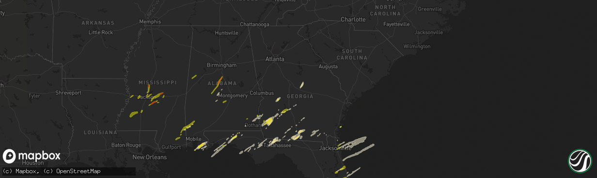
Hail Map in Georgia on January 22, 2017
The weather event in Georgia on January 22, 2017 includes Hail map. 4 states and 209 cities were impacted and suffered possible damage. The total estimated number of properties impacted is 3,095.
Want more than just the map?
Turn this storm into a full workflow.
- Owner + property data so you know who to knock
- OnDemand branded weather history reports to win the "did we even have hail?" argument
- RoofTrace estimate so reps stop guessing numbers at the door
Bought this map? Upgrade within 7 days and we'll credit the $230. (10-15 min setup call)
Hail
3,095
Estimated number of impacted properties by a 1.00" hail or larger0
Estimated number of impacted properties by a 1.75" hail or larger0
Estimated number of impacted properties by a 2.50" hail or largerStorm reports in Georgia
Georgia
| Date | Description |
|---|---|
| 01/22/20175:40 PM CST | Trees down 2 miles east of i-95 near exit 22. Possible tornado. |
| 01/22/20175:29 PM CST | Tds signature by dual pol near woodbine. |
| 01/22/20175:26 PM CST | Ef1 with winds of 100 to 110mph. Path length 16.63 mi. Max width 120 yards. |
| 01/22/20175:20 PM CST | A local report indicates 70 MPH wind near 2 E FOLKSTON |
| 01/22/20174:21 PM CST | Multiple trees down on highway 32 in coffee county. |
| 01/22/20174:00 PM CST | Single wide trailer home flipped over... 2 chicken houses destroyed... 1 chicken house damaged... Trees down... And irrigation pivot turned upside down near hebron chur |
| 01/22/20173:45 PM CST | Emergency manager reported multiple trees down southwest of douglas.the time given was based on radar. |
| 01/22/20173:45 PM CST | Multiple trees down on highway 32 in coffee county. |
| 01/22/20173:45 PM CST | Emergency manager reported single wide mobile home damaged south of douglas. |
| 01/22/20173:45 PM CST | Trees reported down in lake park |
| 01/22/20173:31 PM CST | Power lines reported down on grassy pond rd |
| 01/22/20173:30 PM CST | Tree down on house and power lines down on 5 houses in pinecliff dr area of valdosta. Trees down across valdosta and lake park area. |
| 01/22/20173:20 PM CST | The colquitt electric membership corporation reported numerous power poles and lines down through portions of berrien...brooks...colquitt...cook...and lowndes counties. |
| 01/22/20173:15 PM CST | Damaged reported along american legion rd....with houses heavily damaged....semi trucks turned over...and trees down. |
| 01/22/20173:10 PM CST | The colquitt electric membership corporation reported numerous power poles and lines down through portions of berrien...brooks...colquitt...cook...and lowndes counties. |
| 01/22/20173:09 PM CST | Preliminary report of damage to 4 homes about 4 miles north of rebecca on hwy 112. |
| 01/22/20173:00 PM CST | Ef3 tornado from dougherty and worth counties continued into turner county with ef3 damage found in turner county as well. Additional details will follow on wednesday. |
| 01/22/20173:00 PM CST | Possible tornado- widespread damage between hwy 82 and hwy 32. Trees on houses... In houses... And over roads. Power outages in sylvester. No injuries or fatalities. |
| 01/22/20172:56 PM CST | Significant damage to mobile homes along south 7th street. Additional damage extended northeast from this point on the south and east side of cordele. Tornado possible. |
| 01/22/20172:55 PM CST | Numerous trees down along with structural damage to building near ga-hwy 300 and pateville road. Possible tornado. Time estimated from radar. |
| 01/22/20172:42 PM CST | Ef3 tornado from dougherty county continued into worth county with ef3 damage found in worth county as well. Additional details will follow on wednesday. |
| 01/22/20172:27 PM CST | 74 mph gust measured at the albany airport |
| 01/22/20172:25 PM CST | *** 4 fatal *** dougherty county portion of tornado rated ef3. Additional details on damage...path width...and path length will follow on wednesday. Tornado tracked int |
| 01/22/20172:20 PM CST | *** 4 fatal *** multiple reports of tornado damage in dougherty county |
| 01/22/20171:49 PM CST | Ef2 tornado moved from clay county through far northwest calhoun county and into randolph county before lifting with damage to trees and structures |
| 01/22/20171:48 PM CST | Possible tornado damage. 14 mile path of damage from clay county to coleman to shellman. Trees fell on multiple homes and a mobile home flipped over. No injuries or fat |
| 01/22/20171:45 PM CST | Trees down throughout early county... But especially in the blakely and arlington areas. |
| 01/22/20171:44 PM CST | Ef2 tornado moved from clay county through far northwest calhoun county before moving into randoplh county. |
| 01/22/20171:39 PM CST | Tornado touched down in clay county and moved into far northwest calhoun county and then randolph county. Rated ef2 with damage to structures and trees. |
| 01/22/20171:24 PM CST | Widespread tree damage throughout county... Heaviest near ft. Gaines area. |
| 01/22/201711:00 AM CST | The colquitt electric membership corporation reported numerous power poles and lines down through portions of berrien...brooks...colquitt...cook...and lowndes counties. |
| 01/22/201710:35 AM CST | The colquitt electric membership corporation reported numerous power poles and lines down throughout portions of berrien...brooks...colquitt...cook...and lowndes counti |
| 01/22/201710:11 AM CST | Multpile trees reported down across arabi warwick road in southern crisp county. |
| 01/22/20178:00 AM CST | Tree down on pine hill road |
| 01/22/20177:40 AM CST | 3 reports of trees down in lanier county |
| 01/22/20176:55 AM CST | Multiple downed trees on shiloh highway. Time estimated by radar. |
| 01/22/20176:50 AM CST | Power lines down around boston |
| 01/22/20176:45 AM CST | Trees down near homerville georgia. |
| 01/22/20176:44 AM CST | Em reports power lines down on hwy 187. Time of event estimated with radar. |
| 01/22/20176:25 AM CST | Power lines down on fredonia road |
| 01/22/20176:25 AM CST | House damaged on swan drive. |
| 01/22/20176:20 AM CST | Report of building damaged at 3000 block of bemiss road. |
| 01/22/20176:10 AM CST | Tree down at highway 133 and studstill rd. |
| 01/22/20176:00 AM CST | Survey found an ef1 tornado track from far western lowndes county starting near 30.91...-83.42 around 7 am and ending near 30.91...-83.32 around 704 am. Tracked near st |
| 01/21/20176:05 PM CST | Emergency manager reported quarter sized hail. |
All States Impacted by Hail Map on January 22, 2017
Cities Impacted by Hail Map on January 22, 2017
- McIntosh, AL
- Arlington, GA
- Damascus, GA
- Morgan, GA
- Leary, GA
- Newton, GA
- Quitman, GA
- Andersonville, GA
- Americus, GA
- Ellaville, GA
- Havana, FL
- Defuniak Springs, FL
- Summerdale, AL
- Foley, AL
- Osteen, FL
- Geneva, FL
- Ashburn, GA
- Warwick, GA
- Arabi, GA
- Rochelle, GA
- Pitts, GA
- Citronelle, AL
- Vinegar Bend, AL
- Leesburg, FL
- Selma, AL
- Leesburg, GA
- Greenville, FL
- Ray City, GA
- Lakeland, GA
- Valdosta, GA
- Moody Afb, GA
- Hahira, GA
- Naylor, GA
- Newville, AL
- Fort Gaines, GA
- Headland, AL
- Shorterville, AL
- Abbeville, AL
- Columbia, AL
- Orlando, FL
- Westville, FL
- Bonifay, FL
- Orange Beach, AL
- Belle Glade, FL
- Oakfield, GA
- Tallahassee, FL
- Atlantic Beach, FL
- Jacksonville, FL
- Deland, FL
- Magnolia Springs, AL
- Fairhope, AL
- Robertsdale, AL
- Elberta, AL
- Quincy, FL
- Midway, FL
- Gulf Shores, AL
- Seminole, AL
- Irwinton, GA
- Danville, GA
- Toomsboro, GA
- Tavares, FL
- Okahumpka, FL
- Oviedo, FL
- Paisley, FL
- Umatilla, FL
- Sumterville, FL
- Groveland, FL
- Eustis, FL
- Bushnell, FL
- Folkston, GA
- Coleman, GA
- Bluffton, GA
- Eglin Afb, FL
- Mary Esther, FL
- Navarre, FL
- Saint Cloud, FL
- Yalaha, FL
- Lynn Haven, FL
- Altha, FL
- Youngstown, FL
- Panama City, FL
- Panama City Beach, FL
- Sparks, GA
- Adel, GA
- Lake Park, GA
- Saint Augustine, FL
- Thomasville, GA
- Frisco City, AL
- Cocoa, FL
- Albany, GA
- Colquitt, GA
- Blakely, GA
- Oglethorpe, GA
- Whigham, GA
- Cairo, GA
- Lucedale, MS
- Willacoochee, GA
- Ambrose, GA
- Blountstown, FL
- Chattahoochee, FL
- Bristol, FL
- Lillian, AL
- Center Hill, FL
- Grand Island, FL
- Frostproof, FL
- New Smyrna Beach, FL
- Ormond Beach, FL
- Daytona Beach, FL
- Alapaha, GA
- Saint Simons Island, GA
- Yulee, FL
- Fernandina Beach, FL
- Dawson, GA
- Valparaiso, FL
- Niceville, FL
- Crestview, FL
- Moultrie, GA
- Pavo, GA
- Ocala, FL
- Jakin, GA
- Crescent City, FL
- Bunnell, FL
- Georgetown, FL
- Palm Coast, FL
- Minter, AL
- Edgewater, FL
- Oak Hill, FL
- Mims, FL
- Christmas, FL
- Abbeville, GA
- Fargo, GA
- The Villages, FL
- Mount Dora, FL
- Brooksville, FL
- Wildwood, FL
- Manor, GA
- Homerville, GA
- Waycross, GA
- Wewahitchka, FL
- Winter Springs, FL
- Fort Walton Beach, FL
- Shalimar, FL
- Billingsley, AL
- Titusville, FL
- Monticello, FL
- Hartford, AL
- Newton, AL
- Coolidge, GA
- Fort Meade, FL
- Babson Park, FL
- Lake Wales, FL
- Plantersville, AL
- Randolph, AL
- Jemison, AL
- Marion Junction, AL
- Calera, AL
- Lawley, AL
- Montevallo, AL
- Marion, AL
- Stanton, AL
- Maplesville, AL
- Hayneville, AL
- Letohatchee, AL
- Eutaw, AL
- Gordo, AL
- Aliceville, AL
- Ozark, AL
- Vancleave, MS
- Perkinston, MS
- Sunflower, AL
- Wagarville, AL
- Tibbie, AL
- Leakesville, MS
- Deer Park, AL
- Hurlburt Field, FL
- De Leon Springs, FL
- Vicksburg, MS
- Roxie, MS
- Hazlehurst, MS
- Fayette, MS
- Union Church, MS
- Wesson, MS
- McCall Creek, MS
- Meadville, MS
- Brookhaven, MS
- Edwards, MS
- Bolton, MS
- Raymond, MS
- Canton, MS
- Vaughan, MS
- Ridgeland, MS
- Madison, MS
- Tougaloo, MS
- Jackson, MS
- Flowood, MS
- Brandon, MS
- Pearl, MS
- Florence, MS
- Forest, MS
- Braxton, MS
- Morton, MS
- Pelahatchie, MS
- Harrisville, MS
- Mendenhall, MS
- Lake, MS
- Raleigh, MS
- Magee, MS
- Neptune Beach, FL
- Jacksonville Beach, FL


