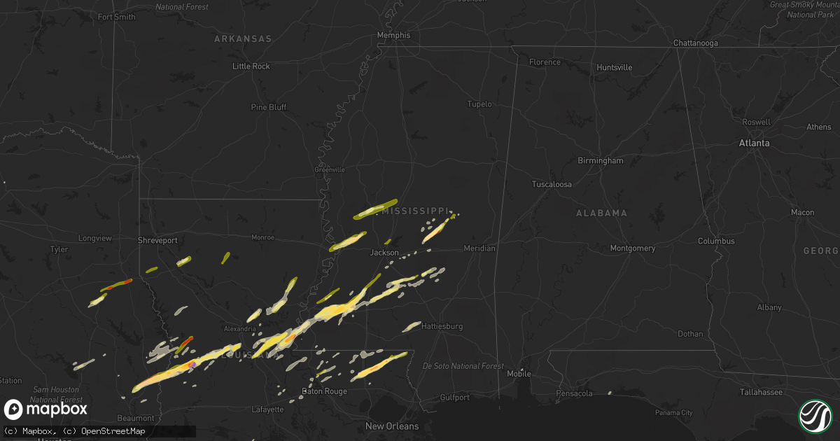
Hail Map in Mississippi on January 21, 2016
Get this storm
January 21 map
$229
one time, instant access
Download today. No call, no setup
Keep the $229
Bought the map and want the full workflow? Apply the entire $229 to a subscription within 7 days. None of it is wasted.
Every map, not just this one
This buys you this map. Subscription and you get every map we run, in the markets you choose from a few cities to whole states to nationwide. Plus real-time alerts the moment a storm fires.
Contact data
Name, contact info, occupancy, even credit band for addresses in the footprint. You go from where it hit to who to call.
Become the source they trust
Unlimited branding weather history reports on demand. You already have the documented answer ready for the property owner, and you are the one who showed up with it.
Property data and RoofTrace estimates
Pull up any address you have got, its value and the exact code rules for that jurisdiction, straight from One Click Code. Then RoofTrace estimates the squares, pitch, and roof value, priced the way you price.
Storm reports in Mississippi
Mississippi
| Date | Description |
|---|---|
| 01/21/20165:46 PM CST | This weak tornado snapped a handfull of large pine trees off cr 562 and 550. A few other large limbs were broken off as well. Path length was 2.1 miles...75 yds wide... |
| 01/21/20165:40 PM CST | Tree down in town along with small dime sized hail. |
| 01/21/20165:31 PM CST | A local report indicates 1.00 inch wind near 2 N PHILADELPHIA |
| 01/21/20165:27 PM CST | Multiple trees and power lines down in the pinola area...hwy 43 n blocked by trees with other trees down along hwy 28. Likely tornado. Other trees were down across part |
| 01/21/20165:20 PM CST | Multiple trees and power lines down in the pinola area. A mobile home had a large portion of its roof blown off. Tornado was rated ef1 with max winds of 95 mph. Path le |
| 01/21/20165:17 PM CST | Report of quarter size hail at lake lincoln in northeast lincoln county. |
| 01/21/20165:15 PM CST | Cocorahs observer reports dime to quarter size hail in rockport. |
| 01/21/20165:15 PM CST | Report of quarter size hail at lake lincoln in northeast lincoln county. |
| 01/21/20164:50 PM CST | Pinetop blown out of a tree in roadway at highway 15 south. Also report of dime size hail on highway 15 west of philadelphia. |
| 01/21/20164:35 PM CST | Report of a large tree down at the 3600 block of old red star road. |
| 01/21/20164:32 PM CST | Damage occurred on lott smith road. One house with severe damage...one structure with minor damage...one travel trailer/shed destroyed. Damage to three barns and numero |
| 01/21/20164:25 PM CST | Numerous trees uprooted/down. A couple of homes had roof damage along with damage to a couple of sheds. Tornado rated an ef1 with max winds of 100 mph. Path length 5.4 |
| 01/21/20164:14 PM CST | Some trees were snapped and shingles pealed off the roof of a home. Some tin was pealed off the roof of another home. Tornado was rated ef0 with max winds of 85 mph. Pa |
| 01/21/20164:13 PM CST | Few trees down on bunkley road. |
| 01/21/20164:10 PM CST | Reports of tree down on powerline on north azalea drive. Power is out in the area. Tree down blocking road on madison avenue near stonegate drive. Tree down blocking tr |
| 01/21/20164:10 PM CST | A local report indicates 1.50 inch wind near 3 E WALNUT GROVE |
| 01/21/20164:10 PM CST | Report of quarter size hail in caseyville covering the ground. |
| 01/21/20164:05 PM CST | Report of quarter size hail on hwy 220 and highland colony. Relayed via ham radio operator. |
| 01/21/20164:04 PM CST | Large tree down. |
| 01/21/20164:02 PM CST | Reports of quarter size hail in crystal springs...which dented some vehicles. |
| 01/21/20164:00 PM CST | A local report indicates 1.00 inch wind near HARPERVILLE |
| 01/21/20164:00 PM CST | Report of golf ball size hail on the road on union church road northeast of meadville. |
| 01/21/20163:35 PM CST | A local report indicates 1.00 inch wind near 3 W CLINTON |
| 01/21/20163:35 PM CST | Tree and powerlines downed along e wilderness rd |
| 01/21/20163:20 PM CST | Report of a few trees down in the cranfield/liberty road area s of cranfield. Also some tree limbs were downed. |
| 01/21/20163:10 PM CST | Power lines down along hwy 61 near white apple. |
| 01/21/20162:31 PM CST | A local report indicates 1.00 inch wind near YAZOO CITY |
| 01/21/20162:30 PM CST | Broad swath of sporadic tree damage extending from southwest of yazoo city northeast to near benton...a few sheds were destroyed and two windows were blown out at a sch |
| 01/21/20168:11 AM CST | Hail up to quarter size along hwy 553 covering the ground. |
| 01/21/20168:11 AM CST | Hail up to quarter size along hwy 553 covering the ground. |
| 01/20/20168:40 PM CST | Couple of trees down off of bunkley rd. |
| 01/20/20167:45 PM CST | Trees down along walker bottom rd. |
| 01/20/20167:27 PM CST | Multiple trees down around enterprise. |
| 01/20/20167:26 PM CST | Tree down across cr 320 |
| 01/20/20166:51 PM CST | 10-12 homes with significant damage...some with major damage. Mostly roof damage. Multiple trees and powerlines downed. Possible tornado. |
| 01/20/20166:49 PM CST | Homes with significant damage...some with major damage. Mostly roof damage. Multiple trees and powerlines downed. Tornado rated ef2 with maximum winds 115 mph...path le |
| 01/20/20166:45 PM CST | A local report indicates 1.25 inch wind near IMPROVE |
| 01/20/20166:38 PM CST | Tree down in bay springs |
| 01/20/20166:15 PM CST | Report of multiple trees down throughout the county. One such report on hwy 501. Report by em of estimated 40-50mph wind gusts in raleigh. |
| 01/20/20166:15 PM CST | Report of quarter size hail on hwy 540. |
All States Impacted by Hail Map on January 21, 2016
Cities Impacted by Hail Map on January 21, 2016
- Kentwood, LA
- Raleigh, MS
- Marksville, LA
- Rockwall, TX
- Glenmora, LA
- Forest Hill, LA
- Jasper, TX
- Florence, MS
- Wiergate, TX
- Many, LA
- Merryville, LA
- Deridder, LA
- Buna, TX
- Call, TX
- Kirbyville, TX
- Bon Wier, TX
- Redwood, MS
- Vicksburg, MS
- Jena, LA
- Pineville, LA
- Pollock, LA
- Deville, LA
- Amite, LA
- Franklinton, LA
- Loranger, LA
- Mount Olive, MS
- Mendenhall, MS
- Mize, MS
- Magee, MS
- Forney, TX
- Sunnyvale, TX
- Morton, MS
- Pelahatchie, MS
- Lecompte, LA
- Mary Esther, FL
- Fort Walton Beach, FL
- Livingston, TX
- Onalaska, TX
- Moreauville, LA
- Simmesport, LA
- Bentonia, MS
- Natchez, MS
- Pinola, MS
- Mount Hermon, LA
- Tylertown, MS
- Ringgold, LA
- Coushatta, LA
- Hall Summit, LA
- Hessmer, LA
- Cottonport, LA
- Bunkie, LA
- Mansura, LA
- Philadelphia, MS
- Forest, MS
- Union, MS
- Walnut Grove, MS
- Kaplan, LA
- Pearl, MS
- Royse City, TX
- Yazoo City, MS
- Roxie, MS
- Brandon, MS
- Abbeville, LA
- Wesson, MS
- McCall Creek, MS
- Meadville, MS
- Brookhaven, MS
- Hazlehurst, MS
- Union Church, MS
- Ethel, LA
- Jackson, LA
- Lettsworth, LA
- Braxton, MS
- Effie, LA
- Husser, LA
- Independence, LA
- Morgan City, LA
- Gloster, MS
- Nacogdoches, TX
- Ville Platte, LA
- Newton, TX
- Centreville, MS
- Norwood, LA
- Pride, LA
- Baker, LA
- Zachary, LA
- Pitkin, LA
- Saint Francisville, LA
- Buras, LA
- Venice, LA
- Batchelor, LA
- Monterey, LA
- Benton, MS
- Anacoco, LA
- Evans, LA
- Sugartown, LA
- Dry Creek, LA
- Clinton, LA
- Carthage, MS
- Leesville, LA
- Monticello, MS
- Newhebron, MS
- Greenville, TX
- Harrisville, MS
- Sumrall, MS
- Foxworth, MS
- Columbia, MS
- Jonesville, LA
- Oakdale, LA
- Silsbee, TX
- Burkeville, TX
- Slaughter, LA
- Taylorsville, MS
- Bay Springs, MS
- Port Allen, LA
- Woodville, MS
- Grant, LA
- Florien, LA
- Fisher, LA
- Greensburg, LA
- Chester, TX
- Rosedale, LA
- Longville, LA
- Krotz Springs, LA
- Maringouin, LA
- Grosse Tete, LA
- Kountze, TX
- Acme, LA
- Fayette, MS
- Mobile, AL
- Lena, MS
- Holden, LA
- Angie, LA
- Pattison, MS
- Arnaudville, LA
- Georgetown, MS
- Vidalia, LA
- Plaucheville, LA
- Bude, MS
- Cheneyville, LA
- Beaumont, TX
- Sicily Island, LA
- Harrisonburg, LA
- Woodworth, LA
- Port Barre, LA
- Pickens, MS
- Prentiss, MS
- Ball, LA
- Saint Martinville, LA
- Warren, TX
- Hillister, TX
- Clinton, MS
- Jonesboro, LA
- Louin, MS
- Glynn, LA
- Erwinville, LA
- Ragley, LA
- Greenwell Springs, LA
- Hammond, LA
- Lorman, MS
- Gilbert, LA
- Lexington, MS
- Vaughan, MS
- Evergreen, LA
- Ridgeland, MS
- Madison, MS
- Tallulah, LA
- Crystal Springs, MS
- New Llano, LA
- Joaquin, TX
- Garrison, TX
- Tenaha, TX
- Timpson, TX
- Logansport, LA
- Grand Cane, LA
- Douglass, TX
- Quitman, LA


