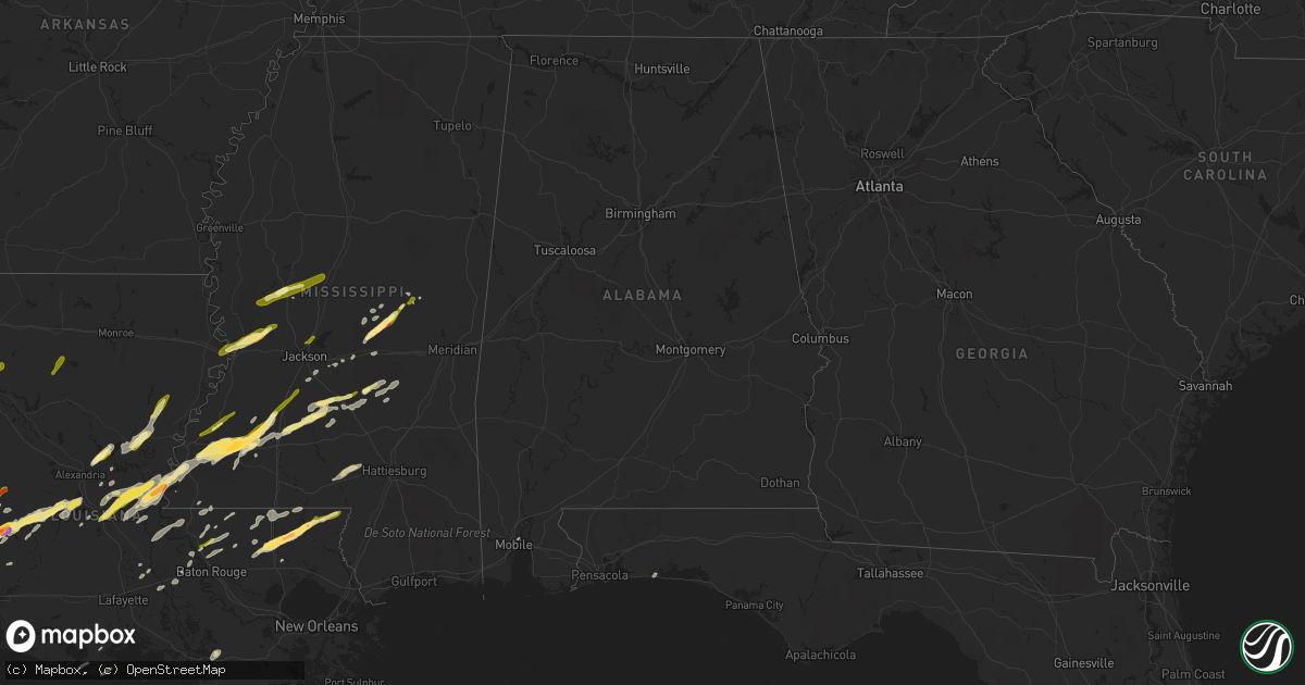
Hail Map in Alabama on January 21, 2016
Get this storm
January 21 map
$229
one time, instant access
Download today. No call, no setup
Keep the $229
Bought the map and want the full workflow? Apply the entire $229 to a subscription within 7 days. None of it is wasted.
Every map, not just this one
This buys you this map. Subscription and you get every map we run, in the markets you choose from a few cities to whole states to nationwide. Plus real-time alerts the moment a storm fires.
Contact data
Name, contact info, occupancy, even credit band for addresses in the footprint. You go from where it hit to who to call.
Become the source they trust
Unlimited branding weather history reports on demand. You already have the documented answer ready for the property owner, and you are the one who showed up with it.
Property data and RoofTrace estimates
Pull up any address you have got, its value and the exact code rules for that jurisdiction, straight from One Click Code. Then RoofTrace estimates the squares, pitch, and roof value, priced the way you price.
Storm reports in Alabama
Alabama
| Date | Description |
|---|---|
| 01/21/20161:25 AM CST | Trees blown down across county highway 228 near the intersection with county highway 230. |
| 01/21/20161:15 AM CST | Trees reported down over county highway 412 near the county line. |
| 01/20/201611:29 PM CST | Multiple trees down in the huxford community. |
| 01/20/201611:29 PM CST | Carport smashed. Barn roof lifted off structure. Trees on a house and car. Very large tree uprooted. Reports via social media. |
| 01/20/201611:29 PM CST | Barn destroyed. Tree limbs snapped off several trees. Screened porch blown in. Reports via social media. |
| 01/20/201611:24 PM CST | Highway 31 in flomaton between bondurant lumber mill and hurricane park is closed due to trees and powerlines down across the road. Time estimated from radar. |
| 01/20/201611:05 PM CST | Roof taken off the porch of a mobile home. Time estimated via radar. |
| 01/20/201611:01 PM CST | Trees down and damage to wooden fence and swingset. Time estimated via radar. |
| 01/20/201611:01 PM CST | Trees and powerlines down off montgomery street in atmore. |
| 01/20/201611:00 PM CST | Trees down. Shed/barn destroyed. |
All States Impacted by Hail Map on January 21, 2016
Cities Impacted by Hail Map on January 21, 2016
- Kentwood, LA
- Raleigh, MS
- Marksville, LA
- Rockwall, TX
- Glenmora, LA
- Forest Hill, LA
- Jasper, TX
- Florence, MS
- Wiergate, TX
- Many, LA
- Merryville, LA
- Deridder, LA
- Buna, TX
- Call, TX
- Kirbyville, TX
- Bon Wier, TX
- Redwood, MS
- Vicksburg, MS
- Jena, LA
- Pineville, LA
- Pollock, LA
- Deville, LA
- Amite, LA
- Franklinton, LA
- Loranger, LA
- Mount Olive, MS
- Mendenhall, MS
- Mize, MS
- Magee, MS
- Forney, TX
- Sunnyvale, TX
- Morton, MS
- Pelahatchie, MS
- Lecompte, LA
- Mary Esther, FL
- Fort Walton Beach, FL
- Livingston, TX
- Onalaska, TX
- Moreauville, LA
- Simmesport, LA
- Bentonia, MS
- Natchez, MS
- Pinola, MS
- Mount Hermon, LA
- Tylertown, MS
- Ringgold, LA
- Coushatta, LA
- Hall Summit, LA
- Hessmer, LA
- Cottonport, LA
- Bunkie, LA
- Mansura, LA
- Philadelphia, MS
- Forest, MS
- Union, MS
- Walnut Grove, MS
- Kaplan, LA
- Pearl, MS
- Royse City, TX
- Yazoo City, MS
- Roxie, MS
- Brandon, MS
- Abbeville, LA
- Wesson, MS
- McCall Creek, MS
- Meadville, MS
- Brookhaven, MS
- Hazlehurst, MS
- Union Church, MS
- Ethel, LA
- Jackson, LA
- Lettsworth, LA
- Braxton, MS
- Effie, LA
- Husser, LA
- Independence, LA
- Morgan City, LA
- Gloster, MS
- Nacogdoches, TX
- Ville Platte, LA
- Newton, TX
- Centreville, MS
- Norwood, LA
- Pride, LA
- Baker, LA
- Zachary, LA
- Pitkin, LA
- Saint Francisville, LA
- Buras, LA
- Venice, LA
- Batchelor, LA
- Monterey, LA
- Benton, MS
- Anacoco, LA
- Evans, LA
- Sugartown, LA
- Dry Creek, LA
- Clinton, LA
- Carthage, MS
- Leesville, LA
- Monticello, MS
- Newhebron, MS
- Greenville, TX
- Harrisville, MS
- Sumrall, MS
- Foxworth, MS
- Columbia, MS
- Jonesville, LA
- Oakdale, LA
- Silsbee, TX
- Burkeville, TX
- Slaughter, LA
- Taylorsville, MS
- Bay Springs, MS
- Port Allen, LA
- Woodville, MS
- Grant, LA
- Florien, LA
- Fisher, LA
- Greensburg, LA
- Chester, TX
- Rosedale, LA
- Longville, LA
- Krotz Springs, LA
- Maringouin, LA
- Grosse Tete, LA
- Kountze, TX
- Acme, LA
- Fayette, MS
- Mobile, AL
- Lena, MS
- Holden, LA
- Angie, LA
- Pattison, MS
- Arnaudville, LA
- Georgetown, MS
- Vidalia, LA
- Plaucheville, LA
- Bude, MS
- Cheneyville, LA
- Beaumont, TX
- Sicily Island, LA
- Harrisonburg, LA
- Woodworth, LA
- Port Barre, LA
- Pickens, MS
- Prentiss, MS
- Ball, LA
- Saint Martinville, LA
- Warren, TX
- Hillister, TX
- Clinton, MS
- Jonesboro, LA
- Louin, MS
- Glynn, LA
- Erwinville, LA
- Ragley, LA
- Greenwell Springs, LA
- Hammond, LA
- Lorman, MS
- Gilbert, LA
- Lexington, MS
- Vaughan, MS
- Evergreen, LA
- Ridgeland, MS
- Madison, MS
- Tallulah, LA
- Crystal Springs, MS
- New Llano, LA
- Joaquin, TX
- Garrison, TX
- Tenaha, TX
- Timpson, TX
- Logansport, LA
- Grand Cane, LA
- Douglass, TX
- Quitman, LA


