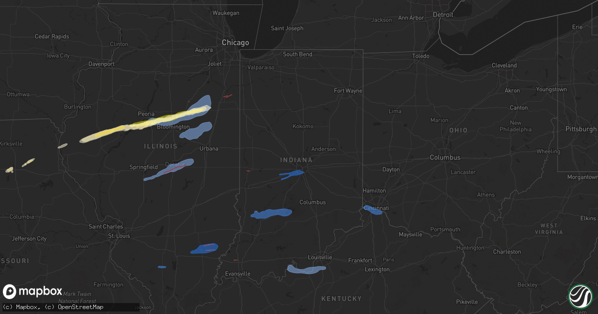
Hail Map in Indiana on December 28, 2025
Get this storm
December 28 map
$229
one time, instant access
Download today. No call, no setup
Keep the $229
Bought the map and want the full workflow? Apply the entire $229 to a subscription within 7 days. None of it is wasted.
Every map, not just this one
This buys you this map. Subscription and you get every map we run, in the markets you choose from a few cities to whole states to nationwide. Plus real-time alerts the moment a storm fires.
Contact data
Name, contact info, occupancy, even credit band for addresses in the footprint. You go from where it hit to who to call.
Become the source they trust
Unlimited branding weather history reports on demand. You already have the documented answer ready for the property owner, and you are the one who showed up with it.
Property data and RoofTrace estimates
Pull up any address you have got, its value and the exact code rules for that jurisdiction, straight from One Click Code. Then RoofTrace estimates the squares, pitch, and roof value, priced the way you price.
Storm reports in Indiana
Indiana
| Date | Description |
|---|---|
| 12/28/20255:55 PM CST | A local report indicates 64 MPH wind near 1 W Knightsville |
| 12/27/20258:33 PM CST | Tree and power lines down in the roadway on ohio avenue. Time estimated from radar. |
| 12/27/20258:25 PM CST | Large tree down blocking us-31. Time estimated from radar. |
| 12/27/20258:23 PM CST | Harrison county dispatch reported that the state highway department had to remove trees from state roadways 135 and 11 around mauckport. Time estimated from radar. |
| 12/27/20258:20 PM CST | Tree down on power lines. Time estimated from radar. |
| 12/27/20258:18 PM CST | Large tree down causing multiple utility poles to bend. Time estimated from radar. |
| 12/27/20258:12 PM CST | Orange county dispatch reported that a tree had to be removed from martinsburg road. Time estimated from radar. |
| 12/27/20257:29 PM CST | Tree down. |
| 12/27/20257:21 PM CST | Tree down on a line and blocking state road 56 e. Road was closed until tree was cut up and line restored. Motorist also hit tree. |
| 12/27/20257:20 PM CST | Trees down in area. Time estimated from radar. |
| 12/27/20257:12 PM CST | Awos station krid richmond municipal airport. |
| 12/27/20256:53 PM CST | Trained spotter estimated 50-60 mp |
| 12/27/20256:53 PM CST | Trained spotter estimated 50-60 mph winds near wesselman park. |
| 12/27/20256:52 PM CST | Large tree limb snapped and dangling over the roadway. |
| 12/27/20256:50 PM CST | Small tree uprooted. Time estimated from radar. |
| 12/27/20256:42 PM CST | Barn roof damaged with pieces of metal blown off. |
| 12/27/20256:42 PM CST | Barn damaged... Pieces of tin blown off roof. |
| 12/27/20256:42 PM CST | Corrects previous tstm wnd dmg report from 3 e cynthiana. Shingles blown off a roof of a home. |
| 12/27/20256:41 PM CST | Trees and powerlines down. Animal shelter sustained some damage to outdoor kennels. |
| 12/27/20256:40 PM CST | Mesonet station in053 i-465 kentucky ave. |
| 12/27/20256:33 PM CST | A local report indicates 61 MPH wind near 1 NE Mccormicks Creek S |
| 12/27/20256:25 PM CST | Shingles blown off a roof... Trees down... One uprooted. Pole snapped. |
| 12/27/20256:25 PM CST | Delayed report. Large tree down. Time estimated via radar. |
| 12/27/20256:18 PM CST | *** 1 inj *** an ef-1 tornado with peak winds of 100 mph and a path length of 1.12 miles began at this location. The path width maximum was 75 yards. |
| 12/27/20256:18 PM CST | Multiple tree damage reports e and ne of vincennes. Time estimated from radar. |
Cities Impacted by Hail Map on December 28, 2025
- Bosworth, MO
- Mendon, MO
- Rothville, MO
- Marceline, MO
- Callao, MO
- Salisbury, MO
- Bevier, MO
- Macon, MO
- New Cambria, MO
- Clarence, MO
- Leonard, MO
- Shelbyville, MO
- Anabel, MO
- Bethel, MO
- Canton, MO
- Warsaw, IL
- La Grange, MO
- Ursa, IL
- Mendon, IL
- Sutter, IL
- Bowen, IL
- Augusta, IL
- Plymouth, IL
- Colchester, IL
- Macomb, IL
- Adair, IL
- Industry, IL
- Table Grove, IL
- Vermont, IL
- Littleton, IL
- Ipava, IL
- Smithfield, IL
- Lewistown, IL
- Cuba, IL
- Bryant, IL
- Canton, IL
- Liverpool, IL
- Saint David, IL
- Manito, IL
- Pekin, IL
- South Pekin, IL
- Green Valley, IL
- Topeka, IL
- Tremont, IL
- Mackinaw, IL
- Groveland, IL
- Morton, IL
- Deer Creek, IL
- Danvers, IL
- Carlock, IL
- Goodfield, IL
- Congerville, IL
- Bloomington, IL
- Hudson, IL
- Normal, IL
- Towanda, IL
- Lexington, IL
- Gridley, IL
- Chenoa, IL
- El Paso, IL
- Secor, IL
- Glasford, IL
- Fairbury, IL
- Forrest, IL
- Colfax, IL
- Chatsworth, IL
- Cullom, IL
- Piper City, IL
- Decatur, IL
- Argenta, IL
- Clifton, IL
- Chebanse, IL
- Saint Anne, IL
- Martinton, IL
- Montezuma, IN
- Mecca, IN
- Rockville, IN
- Johnsonville, IL
- Golden Gate, IL
- Fairfield, IL
- Ellery, IL
- Albion, IL
- East Peoria, IL
- Linton, IN
- Carlisle, IN
- Pontiac, IL
- Cropsey, IL
- Strawn, IL
- Saunemin, IL
- Emington, IL
- Sandborn, IN
- Bloomfield, IN
- Switz City, IN
- Lyons, IN
- Cabery, IL
- Kempton, IL
- Newberry, IN
- Solsberry, IN
- Owensburg, IN
- Springville, IN
- Bloomington, IN
- Bedford, IN
- Heltonville, IN
- Norman, IN
- Coatesville, IN
- Stilesville, IN
- Clayton, IN
- Plainfield, IN
- Indianapolis, IN
- Monrovia, IN
- Mooresville, IN
- Le Roy, IL
- Ellsworth, IL
- Farmer City, IL
- Arrowsmith, IL
- Saybrook, IL
- Bellflower, IL
- Mansfield, IL
- Fisher, IL
- Foosland, IL
- Gibson City, IL
- Sibley, IL
- Camby, IN
- West Newton, IN
- Paxton, IL
- Elliott, IL
- Melvin, IL
- Loda, IL
- Blue Mound, IL
- Macon, IL
- Stonington, IL
- Divernon, IL
- Pawnee, IL
- Edinburg, IL
- Tovey, IL
- Taylorville, IL
- Boody, IL
- Mount Auburn, IL
- Dalton City, IL
- Mt Zion, IL
- Lovington, IL
- Cerro Gordo, IL
- La Place, IL
- Hammond, IL
- Milmine, IL
- Bement, IL
- Cairo, IL
- Barlow, KY
- Wickliffe, KY
- La Center, KY
- Kevil, KY
- Paducah, KY
- West Paducah, KY
- Boaz, KY
- Symsonia, KY
- Hickory, KY
- Benton, KY
- Calvert City, KY
- Gilbertsville, KY
- Hardin, KY
- Murray, KY
- Almo, KY
- Kirksey, KY
- Dexter, KY
- Grand Rivers, KY
- Kuttawa, KY
- Cadiz, KY
- Eddyville, KY
- New Concord, KY
- Princeton, KY
- Dover, TN
- Cerulean, KY
- Hopkinsville, KY
- Bumpus Mills, TN
- Crofton, KY
- Gracey, KY
- Herndon, KY
- Big Rock, TN
- Fort Campbell, KY
- La Fayette, KY
- Oak Grove, KY
- Pembroke, KY
- Clarksville, TN
- Trenton, KY
- Adams, TN
- Guthrie, KY
- Cedar Hill, TN
- Allensville, KY
- Elkton, KY
- Springfield, TN
- Sharon Grove, KY
- Olmstead, KY
- Adairville, KY
- Lewisburg, KY
- Russellville, KY
- Pleasant View, TN
- Chapmansboro, TN
- Joelton, TN
- Goodlettsville, TN
- Greenbrier, TN
- Whites Creek, TN
- Orlinda, TN
- Cottontown, TN
- White House, TN
- Cross Plains, TN
- Franklin, KY
- Hendersonville, TN
- Nashville, TN
- Madison, TN
- Old Hickory, TN
- Hermitage, TN
- Mount Juliet, TN
- Gallatin, TN
- Lebanon, TN
- Castalian Springs, TN
- Watertown, TN
- Milton, TN
- Auburntown, TN
- Liberty, TN
- Alexandria, TN
- Brush Creek, TN
- Dowelltown, TN
- Tamaroa, IL
- Pinckneyville, IL
- Du Quoin, IL
- Miller City, IL
- Fort Branch, IN
- Haubstadt, IN
- Payneville, KY
- Battletown, KY
- Rhodelia, KY
- Cannelton, IN
- Derby, IN
- Alexandria, KY
- Burlington, KY
- Silver Grove, KY
- Florence, KY
- Addyston, OH
- Hebron, KY
- Cincinnati, OH
- Latonia, KY
- Covington, KY
- Erlanger, KY
- Newport, KY
- Fort Thomas, KY
- Melbourne, KY
- Ft Mitchell, KY
- Petersburg, KY
- Webster, KY
- Brandenburg, KY
- Mauckport, IN
- Laconia, IN
- Elizabeth, IN
- Muldraugh, KY
- West Point, KY
- Louisville, KY
- Shepherdsville, KY
- Brooks, KY
- Fairdale, KY
- Wayne City, IL
- Sims, IL
- West Salem, IL
- Geff, IL
- Mount Erie, IL
- Bone Gap, IL
- Cisne, IL
- Browns, IL
- Poplar Bluff, MO
- Broseley, MO
- Fisk, MO
- Bernie, MO
- Dexter, MO
- Dudley, MO
- Bloomfield, MO
- Sikeston, MO
- Essex, MO
- Parma, MO


