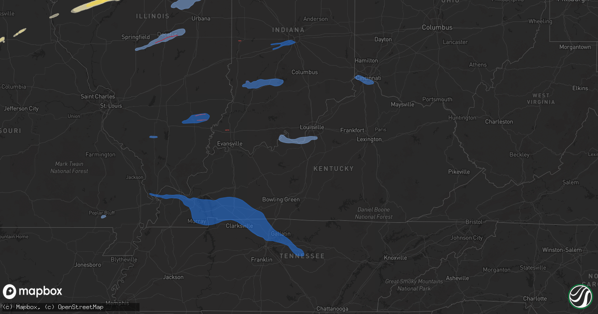
Hail Map in Kentucky on December 28, 2025
Get this storm
December 28 map
$229
one time, instant access
Download today. No call, no setup
Keep the $229
Bought the map and want the full workflow? Apply the entire $229 to a subscription within 7 days. None of it is wasted.
Every map, not just this one
This buys you this map. Subscription and you get every map we run, in the markets you choose from a few cities to whole states to nationwide. Plus real-time alerts the moment a storm fires.
Contact data
Name, contact info, occupancy, even credit band for addresses in the footprint. You go from where it hit to who to call.
Become the source they trust
Unlimited branding weather history reports on demand. You already have the documented answer ready for the property owner, and you are the one who showed up with it.
Property data and RoofTrace estimates
Pull up any address you have got, its value and the exact code rules for that jurisdiction, straight from One Click Code. Then RoofTrace estimates the squares, pitch, and roof value, priced the way you price.
Storm reports in Kentucky
Kentucky
| Date | Description |
|---|---|
| 12/27/202510:20 PM CST | Metcalfe county dispatch reported a tree had to be removed from us 68. A tree was also down at 402 muncie ct. In edmonton. |
| 12/27/202510:20 PM CST | Metcalfe county dispatch reported a tree had to be removed from us 68. A tree was also down at |
| 12/27/202510:20 PM CST | Metcalfe county dispatch reported a tree had to be removed from us 68. A tree was also down at 402 muncie |
| 12/27/202510:20 PM CST | Metcalfe county dispatch reported a tree had to be removed from us 68. A tree was also down at 402 munc |
| 12/27/202510:20 PM CST | Metcalfe county dispatch reported a tree had to be removed from us 68. A tree was also down at 402 muncie c |
| 12/27/202510:20 PM CST | Metcalfe county dispatch reported a tree had to be removed from |
| 12/27/202510:20 PM CST | Metcalfe county dispatch reported a tree had to be removed from us 68. A tree was also down at 402 muncie ct |
| 12/27/202510:20 PM CST | Metcalfe county dispatch reported a tree had to be removed from us 68. A tree was also down at 402 muncie ct. In edmonton. |
| 12/27/202510:02 PM CST | Transformer blown near weaver |
| 12/27/202510:02 PM CST | Transformer blown near weaver dr. Time est by radar. |
| 12/27/20259:50 PM CST | Hart county dispatch reported a tree was completely blocking round bottom road and had to be removed. A tree was also downed on roy cann road. |
| 12/27/20259:49 PM CST | Multiple trees down on vater rd. Time est by radar. |
| 12/27/20259:36 PM CST | Tree down near grants lick elementary t |
| 12/27/20259:36 PM CST | Tree down near grants lick elementary time estimated by radar. |
| 12/27/20259:35 PM CST | Utility line down near sherman mount zion rd. Time est by radar. |
| 12/27/20259:22 PM CST | Tree down time estimated by radar. |
| 12/27/20259:20 PM CST | Tree down on car on garrard st time estimated by radar. |
| 12/27/20259:03 PM CST | Large tree branch snapped. Time estimated from radar. |
| 12/27/20258:46 PM CST | Delayed report of multiple trees down. |
| 12/27/20257:55 PM CST | Windows blown out of businesses and homes on main street. Tree blown into home. Most of flat roof blown off a building further down the street. Mostly diverging damage |
| 12/27/20257:34 PM CST | Trees down... Pole barn damaged. |
| 12/27/20257:19 PM CST | 2 homes lost shingles... A playhouse was rolled. Other minor tree and tree limb damage. Damage was divergent and spread over about a half mile area. Consistent with loc |
| 12/27/20257:15 PM CST | A house had a portion of its roof removed. |
| 12/27/20257:10 PM CST | Sporadic tree limb damage... Powerlines down. |
| 12/27/20257:09 PM CST | A tree was blown down across the road near chester hack drive and bloom avenue. Time estimated from radar. |
| 12/27/20256:41 PM CST | Trees down. |
Cities Impacted by Hail Map on December 28, 2025
- Bosworth, MO
- Mendon, MO
- Rothville, MO
- Marceline, MO
- Callao, MO
- Salisbury, MO
- Bevier, MO
- Macon, MO
- New Cambria, MO
- Clarence, MO
- Leonard, MO
- Shelbyville, MO
- Anabel, MO
- Bethel, MO
- Canton, MO
- Warsaw, IL
- La Grange, MO
- Ursa, IL
- Mendon, IL
- Sutter, IL
- Bowen, IL
- Augusta, IL
- Plymouth, IL
- Colchester, IL
- Macomb, IL
- Adair, IL
- Industry, IL
- Table Grove, IL
- Vermont, IL
- Littleton, IL
- Ipava, IL
- Smithfield, IL
- Lewistown, IL
- Cuba, IL
- Bryant, IL
- Canton, IL
- Liverpool, IL
- Saint David, IL
- Manito, IL
- Pekin, IL
- South Pekin, IL
- Green Valley, IL
- Topeka, IL
- Tremont, IL
- Mackinaw, IL
- Groveland, IL
- Morton, IL
- Deer Creek, IL
- Danvers, IL
- Carlock, IL
- Goodfield, IL
- Congerville, IL
- Bloomington, IL
- Hudson, IL
- Normal, IL
- Towanda, IL
- Lexington, IL
- Gridley, IL
- Chenoa, IL
- El Paso, IL
- Secor, IL
- Glasford, IL
- Fairbury, IL
- Forrest, IL
- Colfax, IL
- Chatsworth, IL
- Cullom, IL
- Piper City, IL
- Decatur, IL
- Argenta, IL
- Clifton, IL
- Chebanse, IL
- Saint Anne, IL
- Martinton, IL
- Montezuma, IN
- Mecca, IN
- Rockville, IN
- Johnsonville, IL
- Golden Gate, IL
- Fairfield, IL
- Ellery, IL
- Albion, IL
- East Peoria, IL
- Linton, IN
- Carlisle, IN
- Pontiac, IL
- Cropsey, IL
- Strawn, IL
- Saunemin, IL
- Emington, IL
- Sandborn, IN
- Bloomfield, IN
- Switz City, IN
- Lyons, IN
- Cabery, IL
- Kempton, IL
- Newberry, IN
- Solsberry, IN
- Owensburg, IN
- Springville, IN
- Bloomington, IN
- Bedford, IN
- Heltonville, IN
- Norman, IN
- Coatesville, IN
- Stilesville, IN
- Clayton, IN
- Plainfield, IN
- Indianapolis, IN
- Monrovia, IN
- Mooresville, IN
- Le Roy, IL
- Ellsworth, IL
- Farmer City, IL
- Arrowsmith, IL
- Saybrook, IL
- Bellflower, IL
- Mansfield, IL
- Fisher, IL
- Foosland, IL
- Gibson City, IL
- Sibley, IL
- Camby, IN
- West Newton, IN
- Paxton, IL
- Elliott, IL
- Melvin, IL
- Loda, IL
- Blue Mound, IL
- Macon, IL
- Stonington, IL
- Divernon, IL
- Pawnee, IL
- Edinburg, IL
- Tovey, IL
- Taylorville, IL
- Boody, IL
- Mount Auburn, IL
- Dalton City, IL
- Mt Zion, IL
- Lovington, IL
- Cerro Gordo, IL
- La Place, IL
- Hammond, IL
- Milmine, IL
- Bement, IL
- Cairo, IL
- Barlow, KY
- Wickliffe, KY
- La Center, KY
- Kevil, KY
- Paducah, KY
- West Paducah, KY
- Boaz, KY
- Symsonia, KY
- Hickory, KY
- Benton, KY
- Calvert City, KY
- Gilbertsville, KY
- Hardin, KY
- Murray, KY
- Almo, KY
- Kirksey, KY
- Dexter, KY
- Grand Rivers, KY
- Kuttawa, KY
- Cadiz, KY
- Eddyville, KY
- New Concord, KY
- Princeton, KY
- Dover, TN
- Cerulean, KY
- Hopkinsville, KY
- Bumpus Mills, TN
- Crofton, KY
- Gracey, KY
- Herndon, KY
- Big Rock, TN
- Fort Campbell, KY
- La Fayette, KY
- Oak Grove, KY
- Pembroke, KY
- Clarksville, TN
- Trenton, KY
- Adams, TN
- Guthrie, KY
- Cedar Hill, TN
- Allensville, KY
- Elkton, KY
- Springfield, TN
- Sharon Grove, KY
- Olmstead, KY
- Adairville, KY
- Lewisburg, KY
- Russellville, KY
- Pleasant View, TN
- Chapmansboro, TN
- Joelton, TN
- Goodlettsville, TN
- Greenbrier, TN
- Whites Creek, TN
- Orlinda, TN
- Cottontown, TN
- White House, TN
- Cross Plains, TN
- Franklin, KY
- Hendersonville, TN
- Nashville, TN
- Madison, TN
- Old Hickory, TN
- Hermitage, TN
- Mount Juliet, TN
- Gallatin, TN
- Lebanon, TN
- Castalian Springs, TN
- Watertown, TN
- Milton, TN
- Auburntown, TN
- Liberty, TN
- Alexandria, TN
- Brush Creek, TN
- Dowelltown, TN
- Tamaroa, IL
- Pinckneyville, IL
- Du Quoin, IL
- Miller City, IL
- Fort Branch, IN
- Haubstadt, IN
- Payneville, KY
- Battletown, KY
- Rhodelia, KY
- Cannelton, IN
- Derby, IN
- Alexandria, KY
- Burlington, KY
- Silver Grove, KY
- Florence, KY
- Addyston, OH
- Hebron, KY
- Cincinnati, OH
- Latonia, KY
- Covington, KY
- Erlanger, KY
- Newport, KY
- Fort Thomas, KY
- Melbourne, KY
- Ft Mitchell, KY
- Petersburg, KY
- Webster, KY
- Brandenburg, KY
- Mauckport, IN
- Laconia, IN
- Elizabeth, IN
- Muldraugh, KY
- West Point, KY
- Louisville, KY
- Shepherdsville, KY
- Brooks, KY
- Fairdale, KY
- Wayne City, IL
- Sims, IL
- West Salem, IL
- Geff, IL
- Mount Erie, IL
- Bone Gap, IL
- Cisne, IL
- Browns, IL
- Poplar Bluff, MO
- Broseley, MO
- Fisk, MO
- Bernie, MO
- Dexter, MO
- Dudley, MO
- Bloomfield, MO
- Sikeston, MO
- Essex, MO
- Parma, MO


