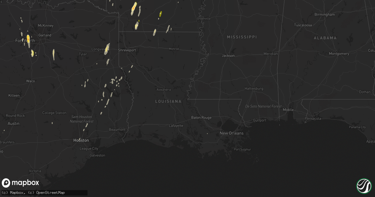
Hail Map in Louisiana on December 27, 2015
Get this storm
December 27 map
$229
one time, instant access
Download today. No call, no setup
Keep the $229
Bought the map and want the full workflow? Apply the entire $229 to a subscription within 7 days. None of it is wasted.
Every map, not just this one
This buys you this map. Subscription and you get every map we run, in the markets you choose from a few cities to whole states to nationwide. Plus real-time alerts the moment a storm fires.
Contact data
Name, contact info, occupancy, even credit band for addresses in the footprint. You go from where it hit to who to call.
Become the source they trust
Unlimited branding weather history reports on demand. You already have the documented answer ready for the property owner, and you are the one who showed up with it.
Property data and RoofTrace estimates
Pull up any address you have got, its value and the exact code rules for that jurisdiction, straight from One Click Code. Then RoofTrace estimates the squares, pitch, and roof value, priced the way you price.
Storm reports in Louisiana
Louisiana
| Date | Description |
|---|---|
| 12/27/20154:42 AM CST | A local report indicates 59 MPH wind near BELLE CHASSE |
| 12/27/20154:39 AM CST | Two power poles blown down by thunderstorm winds near louisiana highway 23 and adam drive in the jesuit bend area. |
| 12/27/20154:30 AM CST | Siding and roof damage to elevated home... Time estimated on radar |
| 12/27/20154:30 AM CST | Nws storm survey found straight line wind damage with powerlines down at fish hatchery rd and sandy rd. |
| 12/27/20153:45 AM CST | Part of a roof blown off a trailer |
| 12/27/20153:30 AM CST | A couple power poles snapped and power lines down at shadowbrook lane |
| 12/27/20153:29 AM CST | Moderate roof damage to shingles on homes at lee drive and jefferson street... Fences down |
| 12/27/20153:20 AM CST | Nws storm survey confirms an ef-1 tornado with winds estimated at 100 mph. Tornado began at around 320am near dupont construction road and continued northeast across hw |
| 12/27/20152:53 AM CST | Nws storm survey confirms an ef-1 tornado with winds estimated at 100mph. The tornado began near highway 190 and woodside drive around 253am and travelled northeast. An |
| 12/27/20152:50 AM CST | Multiple trees and powerlines down along cane market road near varnado road |
| 12/27/20152:45 AM CST | Tree down across levee st...equipment on scene to remove the tree. |
| 12/27/20152:45 AM CST | A parked 18 wheeler truck was blown over into the side of a commercial building along hwy 190...garage doors also blown out... Downed powerlines |
| 12/27/20152:30 AM CST | Downed tree in magnolia oaks subdivision. |
| 12/27/20152:23 AM CST | Tree down at the intersection of mcreight and cherry ridge rd. |
| 12/27/20151:40 AM CST | Tree down across rex poole rd. |
| 12/27/20151:35 AM CST | Trees down on highway 551 |
| 12/27/20151:15 AM CST | Tree down on hattaway rd in calhoun |
| 12/27/201512:55 AM CST | Iberia parish emergency manager reported approximately 20k -30k in damage along mullins road and ben hogan dr. A 50x20 foot piece of sheet metal on a wood frame was tor |
| 12/27/201512:33 AM CST | Trees down at hwy 9 and summerfield. |
| 12/27/201512:15 AM CST | Trees down on hwy 147 |
| 12/27/201512:10 AM CST | Trees down on flowers road and white rd |
| 12/26/201511:45 PM CST | Trees down on hwy 495 and 156 within minutes of each time approx |
| 12/26/201511:40 PM CST | Trees down on spigener rd and hwy 540 in homer vicinity |
| 12/26/201511:10 PM CST | Tornado uprooted and snapped several trees along and north of dutchtown road. |
| 12/26/201511:07 PM CST | Trees down in dykesville. |
| 12/26/201510:45 PM CST | Trees down in heflin... Duberly... Cotton valley... Shongaloo est...1030 - 1115pm across parish |
| 12/26/201510:30 PM CST | Tree down |
| 12/26/201510:20 PM CST | 2 tops out of trees on hwy 784 and one tree down on hand cemetary road |
| 12/26/201510:10 PM CST | Trees down on n hwy 169 |
| 12/26/201510:00 PM CST | Trees down on hwy 80... Lake rd... Chandler and dutch john rd |
| 12/26/20159:01 PM CST | Dixie blanchard rd at sue nation rd |
| 12/26/20158:45 PM CST | 5 mobile homes destroyed. Trees snapped and twisted. |
| 12/26/20158:25 PM CST | Trees snapped and uprooted on blanchard latex rd |
| 12/26/20158:19 PM CST | House damaged intersection of highway one and dixie blanchard road |
| 12/26/20158:16 PM CST | An ef1 tornado moved through two mobile home communities. The tornado lifted one of the mobile homes off of its foundation and caused a tree to fall through another. Se |
| 12/26/20158:10 PM CST | An ef1 tornado snapped and uprooted trees and caused minor damage to a mobile home. The path length was just under one tenth of a mile...the path width was 41 yards...a |
Cities Impacted by Hail Map on December 27, 2015
- Grandview, TX
- Midlothian, TX
- Venus, TX
- Maypearl, TX
- Chatfield, TX
- Scurry, TX
- Kemp, TX
- Kaufman, TX
- Fort Worth, TX
- Arlington, TX
- Haltom City, TX
- North Richland Hills, TX
- Hurst, TX
- Keller, TX
- Wortham, TX
- Richland, TX
- Hope, AR
- Prescott, AR
- Emmet, AR
- Gustine, TX
- Hamilton, TX
- Pottsville, TX
- Goldthwaite, TX
- Star City, AR
- Napoleonville, LA
- Bernice, LA
- Junction City, AR
- Lillie, LA
- Summerfield, LA
- Mansfield, LA
- Roanoke, TX
- Hallsville, TX
- Marshall, TX
- Tatum, TX
- Rhome, TX
- San Saba, TX
- Murfreesboro, AR
- Coupland, TX
- Logansport, LA
- Crowley, TX
- Stamps, AR
- Taylor, AR
- Bronson, TX
- San Augustine, TX
- Magnolia, AR
- Colmesneil, TX
- Woodville, TX
- Cove, AR
- Wickes, AR
- Lampasas, TX
- Lometa, TX
- Hampton, AR
- Chireno, TX
- Nashville, AR
- Center, TX
- Decatur, TX
- Wells, TX
- Alto, TX
- Thrall, TX
- Taylor, TX
- Huntington, TX
- Kennedale, TX
- Colleyville, TX
- Mansfield, TX
- Bedford, TX
- Alvarado, TX
- Waxahachie, TX
- Naval Air Station Jrb, TX
- Houston, TX
- Broaddus, TX
- Laneville, TX
- Euless, TX
- Kerens, TX
- Rice, TX
- Powell, TX
- Waldo, AR
- Paris, TX
- Grapeland, TX
- Kennard, TX
- Moscow, TX
- Corrigan, TX
- Gillham, AR
- Grannis, AR
- Newark, TX
- Splendora, TX
- Cleveland, TX
- New Caney, TX
- Zavalla, TX
- Chester, TX
- Gary, TX
- Converse, LA
- Wimberley, TX
- Driftwood, TX
- Corsicana, TX
- Mexia, TX
- Marion, LA
- Shelbyville, TX
- Alleene, AR
- Ashdown, AR
- Carthage, TX
- Amity, AR
- Horatio, AR
- Huttig, AR
- Eagletown, OK
- De Queen, AR
- Saltillo, TX
- Livingston, TX
- Watson, OK
- Dike, TX
- Kingwood, TX
- Porter, TX
- Strong, AR
- Nacogdoches, TX
- Louann, AR
- Brenham, TX
- Austin, TX
- Buda, TX
- Rosston, AR
- Willisville, AR
- Crockett, TX


